This is a great short walk from Dunkeld Caravan Park. It follows the tree-lined creek from the caravan park into the Arboretum at the weir. From the Arboretum there are good views of Mount Sturgeon and Mount Abrupt.
Participants: Stephen Davies (Photos, Report), Sue Davies
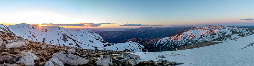
This is a very short tourist walk. Just off the carpark at Reed Lookout, there are excellent views of much of the Grampians Ranges. Moving further along the track there is one nice pedestal-style rock formation and nearby a notable section of mossy ground interspersed with some small flowering shrubs, which looks a little Arctic in nature.
Monday 30/10/2023 Mackenzie Falls Carpark – Mackenzie Falls Lookout – Broken Falls Lookout – Cranages Lookout – Mackenzie Falls – Mackenzie River – Mackenzie River – Fish Falls
Grampians National Park, VICTORIA
Gariwerd Country
Participants: Stephen Davies (Photos, Report), Sue Davies
We had left camp before 7:30am in an attempt to check out this area and The Balconies before meeting friends in Dunkeld at 1:00pm. Having such an early start to the drive ensured we saw lots of wallabies near the road and luckily for several of them we were driving very slowly. After some overnight rain, it was still heavily overcast when we arrived at the carpark and also quite cool.
Saturday 28/10/2023 Mount Zero Picnic Area – Mt Zero Walk – Mount Zero
Grampians National Park, VICTORIA
Gariwerd Country
Participants: Stephen Davies (Photos, Report), Sue Davies
This was our second attempt at this walk, on the 20th we had driven to the start after lunch but decided against it as it was already 32C, calm and cloudless, a little too hot for our liking. At least for this 3:00pm departure, it was only 25C and breezy.
Sunday 29/10/2023 Stapylton Campground – Mount Stapylton Loop Walk (Upper) – Grampians Peak Trail – Mount Stapylton(Gunigalg)(518m) – Taipan Wall – Mount Zero Picnic Area – Mount Stapylton Loop Walk (Lower)
Grampians National Park, VICTORIA
Gariwerd Country
Participants: Stephen Davies (Photos, Report), Sue Davies
After being disappointed last week on the Hollow Mountain walk when we couldn’t find the cave, as per the photograph captioned “Hollow Mountain” in the Parks Victoria Grampians brochure, we thought we might further explore the area in a determined attempt to find it. Inquiries at a National Parks office during the week didn’t throw any further light on where to look. However, having been atop Hollow Mountain last Friday and observing the cliff of Taipan Wall from above I speculated that the cave in the photo may be somewhere along that wall. So off we went on our quest, departing from Stapylton Campground in the cool morning air at 8:40am.
Thursday 19/10/2023 Troopers Creek Campground – Dead Bullock Creek – Gar Waterfalls Walk –Grampians Peaks Trail – Briggs Bluff Track – Gar Campsite – Mount Gar (Mount Difficult)
Grampians National Park, VICTORIA
Gariwerd Country
Participants: Stephen Davies (Photos, Report), Sue Davies
We made our start today by 8:30am, as we had a long walk ahead of us. As this started with an ascent, we thought it would be expedient to get at least some of the climbing behind us before it got too hot. The first couple of kilometres is a gradual ascent through forest along a sandy track, following Dead Bullock Creek upstream. Four waterfalls are encountered along the way, progressively increasing in the height of their drops as you progress. The first barely counts but the last two especially have very decent drops. Today there was just a trickle falling over each, making each more like a weeping wall than a waterfall. Much more interesting today was the colouration of the cliff walls behind these waterfalls, with vertical bands of black, various reddish tones, through to light tans and greys, some broad and others narrow, reflecting the long-term water flow from above.
Participants: Stephen Davies (Photos, Report), Sue Davies
The fine sunny, calm day was beginning to heat up as we got underway at 10:20am. Initially, the track is along a broad, sandy, yellow path, with wooden-faced steps appearing as a gentle ascent begins. This passes through flowering heathland where we noticed a considerable variety of species including Banksia Serrata (Old Man Banksia), Eucalyptus, Melaleuca, Grevillea and Xanthorrhoea. The track then transitions into an increasingly uneven and steepening tree-lined route as it approaches the cliff line. Behind us, as we climbed, we noted more eroded sandstone cliff faces topped with a very jagged skyline.
Monday 16/10/2023 Halls Gap Holiday Park – Grampians Road – Wonderland Loop Walk – Stony Creek – Venus Baths – Splitters Falls – Wonderland Carpark – Turret Falls – Grand Canyon – Cool Chamber – Silent Creek – The Pinnacle – Gate of the West Wind – Relf Peak – Halls Gap to Pinnacle Track – Mackays Peak
Grampians National Park, VICTORIA
Gariwerd Country
Participants: Stephen Davies (Photos, Report), Sue Davies
With a longer walk planned for the day, we walked out of Halls Gap Holiday Park at 9:40am following the Grampians Road to the Botanic Gardens. Walking quickly through the gardens we followed the well-formed yellow, crushed stone Wonderland Loop Walk along Stony Creek. This passed through a low forest with heath in flower and other wildflowers. There were also views of the colourful walls and slopes of surrounding sandstone hillsides.
Participants: Stephen Davies (Photos, Report), Sue Davies
On our way back from our morning walk to Mount Rosea we pulled into Sundial Lookout Carpark, set to complete our day with the 2km walk out to Sundial Lookout (also known as Lakeview Lookout). A glorious blue sky day with an occasional very light breeze saw us leave the carpark around 2:00pm. A hundred metres in, Sue sighted a very dark Singleback lizard basking in the sun trackside. After briefly observing it we moved on. Continue reading →
Tuesday 17/10/2023 Rosea Carpark – Mt Rosea Track – Gate of the East Wind – Mount Rosea (1009m)
Grampians National Park, VICTORIA
Gariwerd Country
Participants: Stephen Davies (Photos, Report), Sue Davies
We were very pleased this very chilly morning to see nothing but blue sky, after five days of cold, heavily overcast and windy weather this was a pleasant change. Our first target today was Mount Rosea, starting with a twenty-minute drive from Halls Gap. We were at the Roses Carpark and walking by 9:30am with no one else or any other vehicles in sight. The first couple of kilometres of this gravel track is relatively level, wide and easy walking through a forest with a heath understory. It then gradually changes into a rougher track with plenty of rocks and slabs as it begins its climb to the ridge above. It was along this section I spied three small yellow canary worms on the track.
Participants: Stephen Davies (Photos, Report), Sue Davies
Starting from Golton Gorge Carpark at 9:10am, it was a short walk along Colton Creek with a gentle climb to the gorge. First through trees before becoming rockier underfoot. As the track reached the creek-side just below Golton Gorge the walk was completely on the bedrock of the creek. Today with very low water flow it was an easy and sure-footed climb up into the gorge. We proceeded as far as the first large waterhole.
Wednesday 11/10/2023 Mount Abrupt Carpark – Mount Abrupt Walking Track – Signal Peak Walking Track – Signal Peak – Mount Abrupt (825m) – Mud-Dadjug Hike-in Campground – C216
Grampians National Park, VICTORIA
Gariwerd Country
Participants: Stephen Davies (Photos, Report), Sue Davies
We departed the carpark at 9:00am, keen for the earlier start as a day reaching the high twenties was forecast. This walk commences climbing immediately from the trailhead and as we found yesterday, passes through a lot of different ecosystems in one day. These often came and went over short distances but the changes were much more noticeable than in many other places we have hiked. The tracks today were not new as they were for The Piccaninny and Mount Sturgeon sections yesterday but these are still high-quality tracks with many sections of steps formed from large flat boulders which have been positioned to make staircases on steeper sections.