Participants: Stephen Davies (Photos), Sue Davies (Report)
After completing the 7:00am parkrun there was still plenty of time to hit the trails. There are 20km of trails on the island and it’s our aim to complete all of these during our stay.
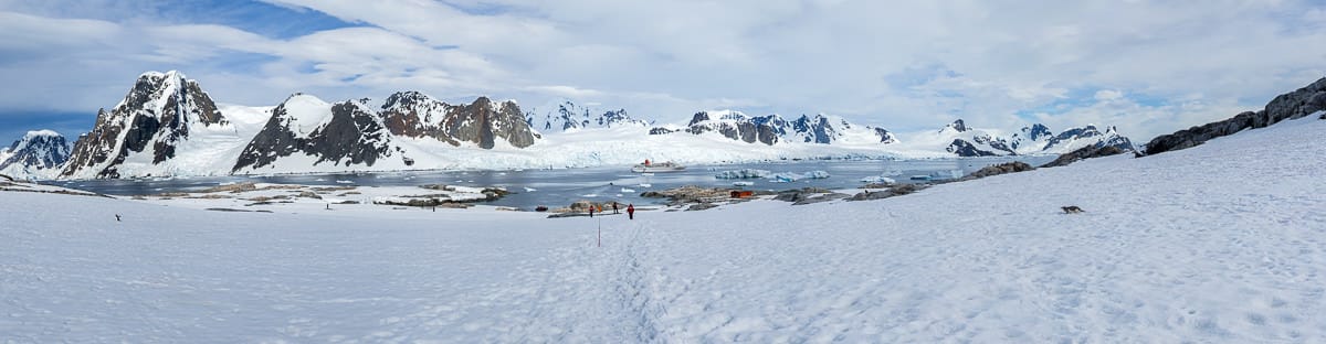
18/03/2026 – 20/03/2026 Lee Bay Road – Lee Bay – Mãori Beach – Wooding Bay – Magnetic Beach – Port William – Port William Hut – North Arm Hut – North Arm – Sawdust Bay Campsite – Kaipipi Road – Ryans Creek Track – Main Road – Kairakau / Halfmoon Bay – Oban
Rakiura Track
Stewart Island / Rakiura
Southland Region, NEW ZEALAND (Aotearoa)
Rakiura Country (Ngãi Tahu people)
Distance: 38.6km Total Ascent: 1275m Total Descent: 1296m
Time: 15 hours
Participants: Stephen Davies (Photos), Sue Davies (Report)
Stepping through the great iron chain at Lee Bay felt like walking across the anchor of an ancient story, the bush and sea already sharing their secrets on the wind. The Rakiura Track here is a gentle, well‑benched path, undulating above the rocky shoreline before slipping into deep, damp forest where rimu and southern rātā lean over the track and the air smells of salt and leaf mould. Underfoot it was mostly firm gravel with the odd muddy patch in hollows, never technical but always asking you to watch your step.
Participants: Beth Davies, Lauren Davies, Stephen Davies (Photos), Sue Davies (Report), Pablo Ureña Vega
We drove the length of Harrington Point Road to its end at Taiaroa Head, where the bitumen runs out at the Royal Albatross Centre car park and the open Pacific announces itself with a steady southerly push. A mild, partly cloudy late-summer day — around 17 degrees — made for comfortable walking.
Tuesday 17/03/2026Golden Bay (Water Taxi) – Paterson Inlet/ Whaka a Te Wera – Post Office Bay – Flagstaff Point – Conservation Walk – Boulder Beach – West End Beach – Post Office Bat Track –
Ulva Island / Te Wharawhara Walking Tracks (including Flagstaff Point Lookout, Boulder Beach Track and West End Beach Track)
Rakiura National Park
Stewart Island / Rakiura
Southland Region, NEW ZEALAND (Aotearoa)
Rakiura Country (Ngãi Tahu people)
Participants: Stephen Davies (Photos), Sue Davies (Report)
We took the water taxi from Golden Bay across Paterson Inlet to Post Office Bay on Ulva Island on a mild March afternoon. The forest rose like a dark green wall ahead — stepping ashore, the stillness was broken only by birdsong. The island is a predator-free sanctuary and it shows.
Monday 16/03/2026 Stewart Island Backpackers – Elgin Terrace – Mill Creek – Horseshoe Bay Road – Butterfield Beach – Horseshoe Point Road – Horseshoe Bay Beach – Horseshoe Point – Simons Beach – Sarah Cove – Braggs Bay Road – Braggs Bay – Moturau Moana Native Gardens
Oban – Half Moon Bay – Horseshoe Point
Stewart Island / Rakiura
Southland Region, NEW ZEALAND (Aotearoa)
Rakiura Country (Ngãi Tahu people)
Participants: Stephen Davies (Photos), Sue Davies (Report)
We set off from the Stewart Island Backpackers in Oban on a cool March morning with scattered showers and a brisk south-westerly — typical Stewart Island weather. The route climbs out past Mill Creek and along Horseshoe Bay Road, the houses thinning as the road rises. It’s straightforward roadside walking with a steady gradient — this island is anything but flat. The views of the coast opened up nicely, with Butterfield Beach curling around below and Horseshoe Point in the distance.
Sunday 15/03/2026 Stewart Island Backpackers – Dundee Street – Fuchsia Walk – Roroa Walk Watercress Beach – Thule Road – Golden Bay Wharf – Golden Bay – Deep Bay Road – Reinga Beach – Petersons Hill Road– Elgin Terrace – Oban
Stewart Island / Rakiura
Southland Region, NEW ZEALAND (Aotearoa)
Rakiura Country (Ngãi Tahu people)
Participants: Stephen Davies (Photos), Sue Davies (Report)
We spent a day wandering the bays and tracks around Oban on Stewart Island on a cool, partly cloudy March afternoon. From the Stewart Island Backpackers we headed along Dundee Street into the Fuchsia Walk — a short climb through native forest to Traill Park, then onto the Raroa Track down to quiet Watercress Bay. The forest track is well-formed with a straightforward descent.
Friday 13/03/2026 Waikawa-Curio Bay Rd – Curio Bay – The Headland
Tumu Toka Curio Bay/Porpoise Bay area
Southland Region, NEW ZEALAND (Aotearoa)
Kāi Tahu Country (Ngāi Tahu people)
Participants: Beth Davies, Stephen Davies (Photos), Sue Davies (Report), Pablo Ureña Vega
We drove along the Waikawa-Curio Bay Road on a cool, breezy March morning with a south-westerly pushing in — clouds stacked over the Catlins coast and the air in the low teens. From the roadside, a short, easy path rolls gently down towards the sea. It’s a wide, well-formed track of gravel, compacted earth and boardwalk with just a few steps and short slopes. Very easy going.
Participants: Stephen Davies (Photos), Sue Davies (Report), Jeremy Harrison, Jamie Murray, Sally Murray, David Rayment, Amy Simone, Julie Wells, Brett Wright (Leader), Lee Wright, Toni
After years of trading stories about our various bushwalking adventures, we finally got out for a walk with Brett and Lee. This Sunday morning hike had us meet at Gambells Rest Campground at 8:25am where our party of eleven completed some introductions before heading off.
Parque Nacional Los Glaciares (Los Glaciares National Park)
Area Lago Viedma
Santa Cruz Province, ARGENTINA
Distance: 75.8km Time: 34 hours
Total Ascent: 2695m Total Descent: 2803m
Participants: Stephen Davies (Photos), Sue Davies (Report), Pedro Navarro (Guide), Patrizia Schäffnerl, Valentina Sobol (Porter)
The Huemul Circuit is not a casual stroll but a full immersion into the raw weather, vast ice and big skies of southern Patagonia.From the moment our small team left El Chaltén and Monte Fitz Roy faded behind us, daily life was replaced by a rhythm of boggy lenga forest, wind‑buffeted passes, creek crossings and evenings spent drying gear beside lakes.
Guided by Pedro, with our porter, Valentina, carrying a very heavy pack and an endless supply of good humour, we circled Cerro Huemul above Lago Viedma, twice crossed the Río Túnel by Tyrolean traverses, and crunched over glacial ice while storms and sun took turns sweeping the Southern Patagonian Ice Field.This report aims to capture an experience that tested creaky knees and comfort zones, but rewarded us with a guanaco on a perfect backdrop, rare orchids, and the quiet satisfaction of finishing one of South America’s toughest and most beautiful treks.
27/11/2025 – 29/11/2025Bariloche – Refugio Emilio Frey – Laguna Toncek – Laguna Jakob Rucaco – Refugio San Martin – Tambo Báez
Parque Nacional Nahuel Huapi
(Nahuel Huapi National Park)
Rio Negro Province
Patagonia Lakes District
ARGENTINA
Distance: 46.6km Time: 21.5hours
Total Ascent: 1692m Total Descent: 1848m
Participants: Stephen Davies (Photos), Sue Davies (Report)
A much-anticipated start after multiple delays.
Getting to the start of the walk was an adventure in itself. We were lined up to board our international flight from Sydney to Buenos Aires when the line came to a standstill. The staff were looking stony-faced as they were given the news. There was no announcement, but they came over to the line and started speaking to individuals. We soon learned that our plane had been “struck by lightning” and the flight was cancelled. Great start to our trip! We were offered overnight accommodation if we didn’t live in Sydney and a meal voucher. A few hours later, I received an email saying our flight had been rescheduled for the following day, 27 hours late. We were transferred by bus to the Holiday Inn Sydney Airport, where they were keen to give us free food. Dinner and breakfast were included as well as the shuttle back to the airport. We settled in for the afternoon.
We did take off at the new time the following day, but I had to adjust our travel plans, accommodations and our flight into Bariloche for the following day. The new flight time, unfortunately, had us waiting for seven hours in Santiago for the connection. We arrived in Buenos Aires close to 10:00pm, and I had organised accommodation close to the airport. Our flight the following day was at 3:15pm, but we had to check out of our accommodation at 10:00am, so we just headed for the airport. We checked our bags in, and soon after, I received an email saying the flight was delayed another six hours! So we had an 11-hour wait at the airport!
We eventually arrived in Bariloche close to midnight and fell asleep as soon as we hit the pillow.
Tuesday 28/10/2025 Kidman’s Camp – PV Jandra – Darling River – North Bourke Bridge – The Big Billabong
Darling River Cruise
North Bourke, NSW
Ngemba Country (Ngemba people)
Participants: Stephen Davies (Photos, Report), Sue Davies
The PV Jandra—a replica of a classic paddle steamer—evoked the era when riverboats shaped regional life and trade. As we glided out from the wharf, our guide shared stories about early river explorers and the crucial relationship of the Darling River to Aboriginal Ngemba people. The backdrop of centuries-old red gums and gnarled coolibahs reflected the enduring life of these waters.