
Wednesday 4/03/2026 Wanaka Mount Aspiring Road – Matukituki River West Branch – Raspberry Creek Carpark – Rob Roy Stream – Rob Roy Glacier Track – Bridal Veil Falls – Rob Roy Glacier
Fiordland National Park / Te Wāhipounamu
South West New Zealand World Heritage Area, Southland, NEW ZEALAND (Aotearoa)
Tahu Country (Ngāi Tahu / Kāi Tahu people)
Participants: Beth Davies, Stephen Davies (Photos), Sue Davies (Report), Pablo Ureña Vega
It is about a one-hour drive from Wanaka to the Raspberry car park. There is about 30km of gravel, as well as a few shallow (at this time of year) fords. We arrived at about 10:00am at the already busy car park.
Max elevation: 765 m
Total climbing: 560 m
Total descent: -540 m
Average speed: 3.31 km/h
Total time: 04:58:42
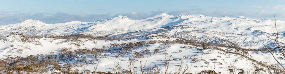
Steve and I had done this walk at least 10 years ago, but it was a new one for Beth and Pablo. We ambled down to the swing bridge, and the steep-sided glacial valley already made for dramatic scenery. The trail climbs gradually through beech forest, following the West Matukituki River with its cascading aquamarine waters.

Pablo, Beth and Sue near Bridal Veil Falls
We continued climbing until we reached the lower lookout for views of the hanging glacier through the trees. The trail from this point is rockier, but it’s definitely worth continuing to the upper lookout for the panoramic views of the glacier, waterfalls and surrounding peaks. We continued down to the river on a minor trail for a different perspective.
After lunch, we returned along the same trail. We were surprised by the number of people heading up. It was quite warm in the afternoon by the time we returned to the car.
The Rob Roy glacier is a must-do half-day walk if you are near Mount Aspiring National Park.
Amongst other photographically recorded observations during this walk, we were able to confirm sightings of each of the following species: Buff-tailed Bumble Bee (Bombus terrestris), Honey Mushroom (Armillaria novae-zelandiae)
Wild Adventures Facebook Group
Trip Post
Clickable icons on this world map will open the related trip report
A detailed, searchable trip list with links to reports, photo galleries
Information on Parks signage along the way
Mt Aspiring Station
Welcome to Our Farm
The farm is 2,300 hectares.
We farm 5,000 sheep and 800 cattle. Many of our livestock roam large paddocks and the sheep, especially, graze halfway up the hillsides.
Welcome to Rob Roy Valley
From here the track crosses the Matukituki River then climbs steadily through the forested gorge of Rob Roy Stream to reach a sub-alpine basin above the tree line – a walk of 3 to 4 hours return.
Rob Roy Valley is in Mount Aspiring National Park and provides tantalising glimpses of the pat ine character; lofty peaks, shimmering Stewfields, and the impressive Rob Roy Glacier perched precariously above towering rock walls.
The original swing bridge was built here in 1987 as a National Parks Centennial Project to give access to this spectacular corner of the park. The bridge was replaced in 2013.
The track ends a short distance above the tree line – 730 metres above sea level – a steady climb of 330 metres above this point. Up there you’ll find more information panels, giving you chance to relax, take in the view, and learn more about this upland valley before retracing your steps.
AVALANCHE
The Rob Roy Valley has avalanche paths that can reach the valley floor beyond the Lower Lookout point on this track. Large avalanches are most likely to happen during and after heavy rain or snowfalls, when there is a lot of snow in the high mountains. These conditions are most likely to occur between May and November but may be present at other times of the year. Track users should be aware that this track is not actively managed for its avalanche risk and that the avalanche paths are not marked.
Rivers of Ice
The Rob Roy Glacier once filled this valley. At the peak of glaciation about 20,000 years ago, it flowed into the great Matukituki Glacier, which combined with the Wanaka Glacier to extend a river of ice down the Clutha Valley close to Cromwell.
Rob Roy Glacier is now an ice age remnant, having retreated to a bench above the sheer valley sides. It flows off the south east slopes of Rob Roy Peak and follows the curve of the valley headwalls for about 5 kilometres. At 2,644 metres Rob Roy Peak is the fifth highest in Mount Aspiring National Park. The park still has about 100 glaciers, the largest of them flank Mount Aspiring/Tititea, 10 kilometres due north of here.
New Zealand glaciers are retreating, responding to a warmer climate. However, some glaciers periodically advance after extreme winters, due to being fed by extra snow in the surrounding mountains.
Glacial Features
Glaciers draw off snow that accumulates in the basins above them. It takes about a year for compaction to convert loose, powdery snow into hard, glacial ice. And as a lake feeds a river a nevé or ice lake, is the reservoir that supplies a glacier.
Glaciation has sculpted much of the shape and lie of the land in this region. Glaciers produce features such as cirques – scooped-out basins at the head of valleys – hanging valleys, stepped lakes, moraine deposits and rounded, glacier worn hills called roches moutonnées.
Blocks of ice may regularly fall from a glacier’s terminal face. The effect is spectacular on a hanging glacier like Rob Roy when blocks crack off from the ice cliffs and crash to the valley floor. Melting ice also contributes to the waterfalls that spill over the valley walls.
Schist Happens
The uplift continues and parts of the Southern Alps/ Ka Tiritiri o te Moana are rising at a rate of 10 to 20 millimetres a year, which is meteoric in geological terms. Erosion, however, is keeping the height of the mountains more or less constant. Peaks not topped by glacial ice are sharp-edged and jagged. In contrast, landform that have been submerged under the grinding, scraping impact of a glacier tend to be smooth.
This is Haast Schist, metamorphosed Torlesse greywacke, now exposed to weathering: rain, wind, snow and ice, and freeze-thaw cycles. It is prone to splitting and crumbling, hence the scree slopes, piles of rubble and teetering towers that you see around you now.
YES SCHIST DOES HAPPEN, but slowly. Schist is the predominant rock in the Mount Aspiring region and mainly formed from layers of sand and mud that were deposited on the floor of an ancient sea some 200 million years ago. It was then transformed by intense heat and pressure.
The sediment that made these mountains probably came from parts of Antarctica that were nearby at the time, before being lifted up during the subsequent mountain-building phase.
The uplift of the present Southern Alps/Ka Tiritiri o te Moana began about 5 million years ago, thrusting rock upwards along fractures in the earth’s crust. The most significant of these fractures is the Alpine Fault on the park’s western edge; the smaller Moonlight Fault is thought to be responsible for much of the uplift of the Aspiring massif that stretches 20 kilometres from Rob Roy west to Picklehaube. This is what towers above you now.
The local landscape features, geology, scenic highlights, flora, fauna, Indigenous history, white history and other nearby walks in the area (Perplexity AI Model)
Landscape Features
The hike traverses two physiographically distinct zones within the southern Kepler Mountains sector of Fiordland National Park. The lower section (approximately 200–400 m elevation) follows the western shoreline of Lake Te Anau along a series of low-energy depositional beaches and forested lake terraces. Lake Te Anau, known in Māori as Te Ana-au (‘the cave of swirling water’), covers 344 km² and is the largest lake in the South Island of New Zealand. Its western shoreline — along which the lakeshore section of the Kepler Track traverses — is characterised by narrow sandy beaches interspersed with rocky headlands and forested bluffs. Dock Bay and Brod Bay are two small sand and gravel beaches set within this otherwise predominantly forested shoreline; Brod Bay was named after Thomas Brodrick, skipper of Te Uira, an early passenger vessel on the lake who resided at the bay.
From Brod Bay, the track ascends steeply through mountain and silver beech (Nothofagus spp.) forest for approximately 800 m of vertical gain. The ascent exposes a sequence of glacially modified terrain: lower slope glacial till deposits and lake terraces give way to increasingly steep valley walls as the track climbs the flanks of Mount Luxmore. The prominent Luxmore Bluffs, encountered at approximately 747 m, represent striking near-vertical limestone escarpments that interrupt the otherwise continuous forest cover and provide panoramic vistas of the Te Anau Basin. Above the bluffs, the character of the slope gradually transitions from closed-canopy beech forest to subalpine scrub and the lower margins of the open tussock grassland zone near the bushline.
Geology
The geological foundations of the Kepler Mountains are among the oldest and most complex in New Zealand. The basement comprises metamorphic and plutonic rocks — principally schists, gneisses, and granites — formed at considerable depth in the earth’s crust during the Palaeozoic and early Mesozoic eras, and subsequently exhumed through tectonic uplift and erosion. Resting unconformably upon this crystalline basement are younger sedimentary units, most significantly the Oligocene–Miocene limestones exposed dramatically at the Luxmore Bluffs. These carbonates formed when the region subsided below sea level during a period of marine transgression in the Cenozoic era, accumulating as shallow-marine carbonate sediments rich in coral, shell, and foraminifera fragments; the area was subsequently uplifted and the softer sediments partially eroded, leaving the resistant limestone as a prominent topographic feature. The Luxmore Caves — a system of approximately 30 known karst cavities near Luxmore Hut — formed by dissolution of the limestone by weakly acidic groundwater, and are ornamented with stalactites and stalagmites. The lowlands surrounding Lake Te Anau are blanketed with glacial deposits — moraine, glaciofluvial outwash, and lacustrine sediments — reflecting the powerful glacier systems that repeatedly scoured the Fiordland landscape throughout the Pleistocene, carving the deep fiords, U-shaped valleys, and basins now occupied by the major lakes.
Scenic Highlights
The track offers scenic highlights of exceptional quality across its two landscape zones. At lake level, the translucent turquoise waters of Lake Te Anau, framed by the densely forested slopes of the Murchison Mountains to the north and the Kepler Mountains to the west, present a classic glacially formed freshwater landscape of world heritage significance. The sandy beaches of Dock Bay and Brod Bay, rare on the otherwise rocky lakeshore, afford swimming and rest in a pristine natural setting. As the ascent progresses, the grandeur of the Luxmore Bluffs — towering pale-grey limestone escarpments set against the dark beech forest — provides a dramatic textural contrast and signals the geological complexity of the range. At the upper elevation limits of this particular walk, near the bushline, panoramic views open across the Te Anau Basin, the Takitimu Mountains, and the Snowdon and Earl Mountains, revealing the vast, largely unmodified wilderness expanse of Fiordland National Park.
Local Flora
The vegetation is strongly zonated with elevation. The lakeshore and lower forest section is dominated by mountain beech (Nothofagus solandri var. cliffortioides) and red beech (Nothofagus fusca), with kāmahi (Weinmannia racemosa) prominent in the understorey and on steeper, moister aspects. Rimu (Dacrydium cupressinum) and miro (Prumnopitys ferruginea) occur as scattered emergents. The forest floor is characterised by extensive growths of crown fern (Blechnum discolor) and hard tree fern (Cyathea smithii), along with mosses and liverworts forming a dense, spongy ground layer that is characteristic of the exceptionally high rainfall environment. Higher on the ascent, mountain beech gives way to silver beech (Nothofagus menziesii), which forms the predominant forest type near the bushline. Approaching and at the upper limits of the walk, subalpine species emerge, including Dracophyllum spp., Hebe spp., and the beginnings of snow tussock grassland dominated by Chionochloa spp. — principally Chionochloa flavescens and C. rigida subsp. amara — which become dominant above the bushline. Alpine herb field species including various Celmisia (mountain daisy) species are also encountered.
Local Fauna
The Kepler Track is celebrated for the diversity and abundance of its native birdlife. The beech forests support populations of South Island robin (Petroica australis), South Island tomtit (Petroica macrocephala), grey warbler / riroriro (Gerygone igata), rifleman / tītipounamu (Acanthisitta chloris), bellbird / korimako (Anthornis melanura), and New Zealand fantail / pīwakawaka (Rhipidura fuliginosa). The iconic New Zealand falcon / kārearea (Falco novaeseelandiae) may be encountered at higher elevations. Of particular conservation significance is the Fiordland tokoeka (Apteryx australis australis), a subspecies of the southern brown kiwi endemic to Fiordland, with an estimated population of approximately 12,500–15,000 individuals; while predominantly nocturnal and thus rarely observed during the day, its distinctive calls — a high-pitched screech from the male and a lower hiss from the female — may be heard, particularly near Brod Bay and in the denser forest zones. The kea (Nestor notabilis), New Zealand’s large and highly intelligent alpine parrot, is frequently encountered from the limestone bluff zone upwards. Morepork / ruru (Ninox novaeseelandiae) are active at dusk and through the night. The beech forest habitat also supports populations of long-tailed bat / pekapeka (Chalinolobus tuberculatus). The introduced stoat (Mustela erminea) represents the principal mammalian pest affecting native bird populations, and DOC maintains an active predator control programme along the track corridor.
Indigenous History
The Fiordland region is of profound and enduring significance to Ngāi Tahu (also rendered Kāi Tahu), the principal Māori iwi of the South Island of New Zealand, whose takiwā (tribal territory) encompasses virtually the entire South Island. In the traditions of Ngāi Tahu, the region is known as Te Rua-o-Te-Moko, and its formation is attributed to the demi-god Tūterakiwhanoa, who is said to have carved the fiords and lakes from formless rock. The legendary leader Rākaihautū, who arrived in Aotearoa aboard the waka (canoe) Uruao, is credited in Māori oral tradition with the naming of the great southern lakes: Lake Te Anau was named Te Ana-au (‘the cave of swirling water’) and Lake Manapouri, originally Roto Ua (‘the lake where rain is constant’). In pre-European times, Ngāi Tahu utilised the Fiordland region on a seasonal basis, traversing mountain passes between the east and west coasts of the South Island in search of pounamu (greenstone / nephrite jade), kererū (New Zealand pigeon), fish, and other food resources. Lake Te Anau and its surrounding bays were recognised stopping points on these trails, as evidenced by archaeological material recovered from sites around the lake shore. The Ngāi Tahu land claim in respect of this and much of the South Island was subject to prolonged litigation and was ultimately settled through the Ngāi Tahu Claims Settlement Act 1998, which among other provisions acknowledged Ngāi Tahu rights to pounamu resources throughout the South Island.
Post-Contact and European History
European exploration of the Lake Te Anau area began with the expedition of Charles Nairn and William Stephen on 26 January 1852, who — guided by Māori knowledge of the interior — became the first Europeans to record the lake. Surveyor James McKerrow subsequently mapped the region and named the Kepler Mountains after the 17th-century German astronomer Johannes Kepler. Richard Henry, appointed as Fiordland’s first government ranger, resided at the southern end of Lake Te Anau from the 1890s and undertook extensive exploration of the Kepler Mountains, pioneering conservation work including the translocation of flightless birds to offshore islands. In the late 19th and early 20th centuries, runholder Jack Beer cut early tracks onto the flanks of Mount Luxmore to facilitate summer sheep grazing, establishing a pastoral land use that was later subsumed by the national park designation. The Lake Te Anau Control Structure — the infrastructure at the carpark trailhead — was constructed as part of the Manapōuri Power Scheme (construction 1963–1972, commissioned 1972), regulating the outflow of Lake Te Anau into the Waiau River and thence to Lake Manapouri for hydroelectric generation. The scheme was the subject of the landmark Save Manapouri Campaign of 1969–1972, widely regarded as the catalyst for the modern environmental movement in New Zealand. The Kepler Track itself was designed and constructed in the mid-1980s — with significant physical construction undertaken by Operation Raleigh international expeditions in 1986–87 — and was officially opened in February 1988 as part of the centennial celebrations of the New Zealand national parks system. The track was purpose-built as a recreational amenity, and was not derived from pre-existing Māori or pioneer routes. Luxmore Hut, constructed in 1988, accommodates 54 trampers and is the primary overnight facility on this section of the track.
Clickable icons on this world map will open the related trip report
A detailed, searchable trip list with links to reports, photo galleries
![]()