
Tuesday 17/03/2026 Golden Bay (Water Taxi) – Paterson Inlet/ Whaka a Te Wera – Post Office Bay – Flagstaff Point – Conservation Walk – Boulder Beach – West End Beach – Post Office Bat Track –
Ulva Island / Te Wharawhara Walking Tracks (including Flagstaff Point Lookout, Boulder Beach Track and West End Beach Track)
Rakiura National Park
Stewart Island / Rakiura
Southland Region, NEW ZEALAND (Aotearoa)
Rakiura Country (Ngãi Tahu people)
Participants: Stephen Davies (Photos), Sue Davies (Report)
We took the water taxi from Golden Bay across Paterson Inlet to Post Office Bay on Ulva Island on a mild March afternoon. The forest rose like a dark green wall ahead — stepping ashore, the stillness was broken only by birdsong. The island is a predator-free sanctuary and it shows.
Max elevation: 42 m
Total climbing: 177 m
Total descent: -165 m
Average speed: 2.69 km/h
Total time: 03:58:35
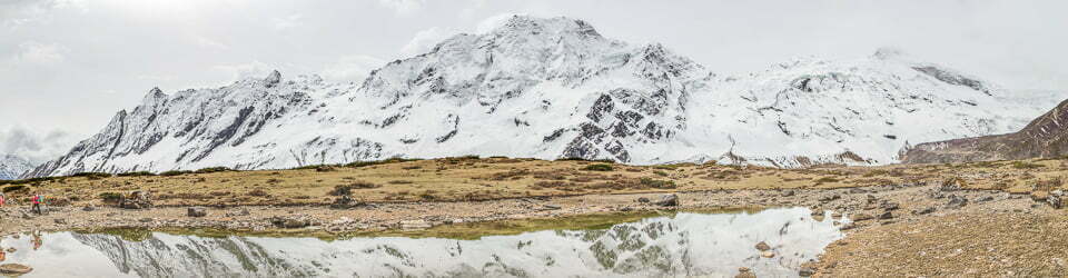
From the jetty, the Flagstaff Point Track climbs gently — a well-formed path with steps and benched sections, straightforward underfoot for anyone with moderate fitness. At the lookout, the canopy fell away to a sweeping view across Paterson Inlet, beaches and distant hills softened by high cloud and hazy sun.

Red-crowned Parakeet (Cyanoramphus novaezelandiae) near Flagstaff Point
Dropping down, we walked the Conservation Walk inland through dense podocarp–broadleaf forest. The air was cool and damp, the track well-formed but littered with roots and fallen leaves. Weka (Gallirallus australis) darted across the path, Tūī (Prosthemadera novaeseelandiae) called from the canopy, and Red-crowned Parakeets (Cyanoramphus novaezelandiae) flashed through the trees. Yellowheads (Mohoua ochrocephala) moved through the understorey — a bird rarely seen on the mainland. The forest floor was rich with ferns — Crown Fern (Lomaria discolor), Kiokio (Blechnum novaezelandiae) and Easter Orchid (Earina autumnalis) were everywhere.

New Zealand Sea Lion (Phocarctos hookeri) on Boulder Beach
The track looped out to Boulder Beach and West End Beach, where the forest peeled back to sheltered coves. A New Zealand Sea Lion (Phocarctos hookeri) hauled out on the sand. An unforgettable walk through pristine native forest. Ulva Island is a must-do on any visit to Stewart Island.
Amongst other photographically recorded observations during this walk, we were able to confirm sightings of each of the following species: Weka (Gallirallus australis), New Zealand Sea Lion (Phocarctos hookeri), Lancewood (Pseudopanax crassifolius), Mniodendron comatum, Kiokio (Blechnum novaezelandiae), Tūī (Prosthemadera novaeseelandiae), Red-crowned Parakeet (Cyanoramphus novaezelandiae), Crown Fern (Lomaria discolor), Kiokio (Blechnum novaezelandiae), Variable Oystercatcher (Haematopus unicolor), Fly Agaric (Amanita muscaria), Easter Orchid (Earina autumnalis), Yellowhead (Mohoua ochrocephala), Lancewood (Pseudopanax crassifolius) Mniodendron colensoi
Wild Adventures Facebook Group
Clickable icons on this world map will open the related trip report
A detailed, searchable trip list with links to reports, photo galleries
From Ulva Island Booklet Guide
Welcome to Ulva Island, one of New Zealand’s few open island sanctuaries.
Ulva Island is the largest of several small islands situated in Paterson Inlet/Whaka a Te Wera, Stewart Island/Rakiura.
The majority of Ulva island (around 260 ha) is part of Rakiura National Park and is managed by the Department of Conservation as an open sanctuary – a place where native plants and birds can live in a safe environment and the public can enjoy them.
The remainder of the island at Post Office Bay is privately owned.
Information on Parks signage along the way
Ulva Island a story worth telling
Mãori traditions
Te Wharawhara is the Mãori name for Sydney Cove and nearby Native Island; an old word that may have indicated a burial cave. Paterson Inlet/Te Whaka a Te Wera teemed with life and provided a food basket for Mãori in pre-European and early contact days. As the largest island in the inlet, Ulva was a popular landing place.
Shaping our identity
Look across to The Neck/Te Wehi a Te Wera from nearby Flagstaff Point and imagine one of New Zealand’s earliest communities of retired sealers/whalers with their Mãori wives. This merging of culture and personal histories has created a strong identity for their descendants.
Charles Traill
Ulva’s first resident Around 1870 Charles Traill opened a small store and in 1872 a post office. The building with the sloping roof (nearest the beach) is the last of the buildings constructed for Charles Traill during his time on the island. He was recognised by eminent scientists as a gifted naturalist and collector of plant and shell specimens.
Nature tourism pioneer
From the first organised excursions in the mid- 1870s, Stewart Island/Rakiura attracted visitors, especially naturalists and artists. A visit to Ulva Island’s ‘most southerly post office in the world’ and exotic plantings by Charles Traill and his brother Walter ranked high on the ‘must-see’ list.
Among New Zealand’s earliest reserves
Ulva Island was at the forefront of New Zealand government policy to foster tourism through an extensive development of parks and reserves. In 1899 it was one of the first places to be protected as a scenic reserve, recognising the national significance of its scenery, flora and fauna.
To a gentleman with an eye for the beautiful in nature… the island ought to be a very paradise. Charles Trail, storekesper, unpaid postmaster and naturalist,
Conservation efforts begun by Charles and Walter Traill have continued to the present day through the work of many passionate people.
Removing rats
Fortunately, possums, stoats and ferrets were never introduced to Ulva Island. But the island was plagued by rats which eat almost anything, including eggs and chicks. Between 1993 and 1997 all rats on the island were eradicated in a major breakthrough for conservation.
Restoring forest life
A rat-free forest has made it safe to reintroduce some of New Zealand’s iconic birds. In 2000 the release of South Island saddleback/tieke celebrated the start of a new century, followed a year later by Stewart Island robin /toutouwai. Free from seed-eating rats, the forest is also restoring itself – tracks are lined with sprouting seedlings!
In 2002 Rakiura National Park became New Zealand’s 14th national park, covering most of Stewart Island. And Ulva Island is the “jewel in its crown”.
The Ulva Island Trust supports the Department of Conservation in its work on the island. Its first project was to replace muddy, slippery tracks with today’s high quality gravel surfaces.
Ulva Island is one of only a handful of open bird sanctuaries in New Zealand, providing a unique experience for all to enjoy.
The local landscape features, geology, scenic highlights, flora, fauna, Indigenous history, white history and other nearby walks in the area (Perplexity AI Model)
Landscape features
The immediate landscape around this walk is a low-relief, drowned valley system where steep, forested shores descend to a broad, sheltered inlet, with Ulva Island forming one of several small islands scattered within Paterson Inlet / Te Whaka a Te Wera. The coastline alternates between rocky headlands, small cliffs and gently shelving, sandy coves such as Post Office Bay, Sydney Cove, Boulder Beach and West End Beach. Inland, the terrain consists of rolling ridges and shallow gullies, with tracks generally following spurs and saddles to maintain moderate gradients and avoid wet hollows. The overall impression is of an intimate, enclosed seascape, where short transitions carry visitors from dense forest to open shoreline and wide views across the inlet.
Geology
Paterson Inlet is a classic example of a ria, an ancient river valley inundated by rising sea levels, producing a complex, indented coastline punctuated by islands such as Ulva Island. The underlying bedrock in this part of Rakiura comprises old, hard rocks associated with the Median Batholith and related intrusive complexes, which weather to form resistant headlands and thin, acidic soils that support dense, evergreen forest. Over time, wave action and slow shoreline processes have reworked sediments into the sandy beaches at Post Office Bay, Sydney Cove, Boulder Beach and West End Beach, where fine to medium sand grades into coarser material towards the back of the shore. The ria setting, combined with limited catchment development, means that sediment input is relatively low, preserving clear coastal waters in the adjacent marine reserve.
Scenic highlights
Key scenic highlights along this route include the elevated vantage at Flagstaff Point Lookout, which provides expansive views across Paterson Inlet to the main mass of Stewart Island / Rakiura and the smaller islands scattered through the inlet. Sydney Cove offers a striking contrast, with a wide, gently curving strip of pale sand, calm water and often visiting sea lions, creating a sheltered, intimate scene framed by forest down to the high-tide line. Boulder Beach and West End Beach provide more open aspects westwards over the Ulva Island / Te Wharawhara Marine Reserve, where offshore islets, reef structures and subtle shifts in water colour hint at rich subtidal communities. Within the forest, the track itself becomes a scenic experience, with tall trees, layered understorey and frequent bird encounters shaping a continuous sense of immersion.
Local flora
Ulva Island supports a highly intact podocarp–broadleaf rainforest typical of the cool, wet maritime climate of Rakiura, with large rimu, miro and totara emerging above a dense canopy of southern rātā and other broadleaf species. The understorey is rich in tree ferns, shrubs, vines and ground ferns, creating a multi-layered structure that produces deep shade and a damp, sheltered microclimate along much of the track. Because the island functions as an open sanctuary that is free of many introduced browsing mammals, regeneration of seedlings and saplings is vigorous, with dense cohorts of young trees visible beside the formed paths. Interpretation panels along the Conservation Walk highlight characteristic plant groups and explain their ecological roles, making the flora a central part of the visitor experience.
Local fauna
Ulva Island is renowned for its abundant and often confiding birdlife, a direct result of pest control and its status as a sanctuary. Visitors walking this route commonly encounter species such as inquisitive weka on the tracks, kākā moving above the canopy, and a range of smaller forest birds feeding and calling within close proximity. Along the beaches, particularly Sydney Cove and sometimes West End Beach, New Zealand sea lions are regularly observed resting on the sand or moving between shore and water. Offshore, the clear, relatively unpolluted waters protected by the Ulva Island / Te Wharawhara Marine Reserve support diverse marine invertebrates and fish, though these communities are mostly experienced indirectly through surface conditions and interpretation rather than direct observation from the walking tracks.
Indigenous history
The wider Paterson Inlet / Te Whaka a Te Wera area has a long and continuous history of Māori presence, particularly associated with Ngāi Tahu and closely related groups such as Kāti Māmoe and Waitaha. Traditional use focused on rich marine and coastal resources, including fisheries, shellfish beds and, more widely in the region, seasonal harvest of tītī (muttonbirds), with customary knowledge informing the later designation of the Te Whaka a Te Wera mātaitai and the Ulva Island / Te Wharawhara Marine Reserve. Archaeological sites, named features and urupā in the inlet underline the depth of this association, and places such as The Neck / Te Wehe a Te Wera served as important settlement and gathering points that supported both pre-contact Māori communities and later mixed Māori–European populations. The contemporary management framework for Ulva Island and the marine reserve acknowledges these relationships and incorporates iwi perspectives into conservation and access arrangements.
White history
European engagement with Ulva Island intensified in the nineteenth century, when land was purchased and a small settlement developed around Post Office Bay. Charles Traill, an Orkney Islander, bought land on the island in the 1860s, established a store and later opened a post office in 1872, giving the bay its enduring name and function as a focal point for communication in the area. A flagstaff was erected on the nearby height now known as Flagstaff Point so that mail arrivals from Bluff could be signalled to residents around Paterson Inlet, linking local communities to broader colonial networks. In 1899 the island was declared a reserve, and over the twentieth century management progressively shifted from resource use towards conservation, culminating in its present role as part of Rakiura National Park and as a flagship open sanctuary and marine reserve destination accessed by water taxi from Golden Bay.
Clickable icons on this world map will open the related trip report
A detailed, searchable trip list with links to reports, photo galleries
![]()