
Monday 8/06/2026 Eastern Tracks
Hamilton Island, QUEENSLAND
Ngaro Country (Nargo people)
Participants: Stephen Davies (Photos), Sue Davies (Report)
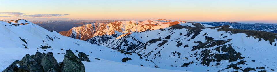
We started the day with a civilised cuppa at the Sails Cafe before walking along Catseye Beach with views of our destination at Passage Peak. We took the Scenic Trail to Saddle Junction with the aim of walking to Middle Head first. There was some confusion with the trail signage, with some backtracking before we reached the pleasant views from Middle Head. There were very few people on these wide pleasant trails.
Max elevation: 228 m
Total climbing: 520 m
Total descent: -498 m
Average speed: 3.52 km/h
Total time: 06:09:19
We then descended and climbed the multiple stairs up to Passage Peak. This was the most popular section of today’s walk, for good reason, with stunning views across to the Whitsundays Islands and down towards the resorts and Catseye Beach. We needed to wait about 20 minutes for a group of Gen Z to finish their endless group photos for us to finalise our one shot!
From here, we commenced the loop walk around the southern peninsula. This was pleasant with views of aquamarine water, craggy headlands viewed through a plethora of Xanthorrhoea and Hoop Pines (similar to Norfolk Island Pines).

We stopped at the giant chair at Southeast Head before continuing down to the shallow waters of Escape Bay. The scenic views continued as we headed north back to Saddle Junction and back along the Scenic Trail to complete the circuit. This was a pleasant and rewarding day walk, and for us, completed with our previous walk, all the trails on this beautiful island.
Amongst other photographically recorded observations during this walk, we were able to confirm sightings of each of the following species: Maybe Hoop Pine (Araucaria cunninghamii), Coastal Grasstree (Xanthorrhoea latifolia), Clearwing Swallowtail (Cressida cressida), Chequered Swallowtail (Papilio demoleus), Blue Tiger (Tirumala hamata), Blue-banded Eggfly (Hypolimnas alimena), Yellow Albatross (Appias paulina), Maybe Green Skimmer (Orthetrum serapia), Varied Eggfly (Hypolimnas bolina), Maybe Cinnabar Bracket (Trametes sanguinea)
Wild Adventures Facebook Group
Clickable icons on this world map will open the related trip report
A detailed, searchable trip list with links to reports, photo galleries
From Hamilton Island Visitor Guide
Hideaway Bay 1.6km 30min
Discover this secluded bay where you can enjoy the tranquil waters and views towards Whitsunday Island.
Flat Top Hill Lookout 1km | 20min
Take in the magical views to the north and south of Hamilton Island. Please note, ATV tours visit this location.
Passage Peak 900m 30min
Breathtaking views of the Whitsundays from the highest point on Hamilton Island, Passage Peak.
Middle Head 1.4km | 30min
Middle Head trail ends at the top of a hill with glimpses of the Whitsunday islands and waters to the south.
Coral Cove 1.3km |30min
Coral Cove is a secluded, peaceful and relaxing beach where you can enjoy views south to Lindeman Island.
Escape Beach 1.6km 40min
A secluded and charming retreat. For the adventurous, include South East Head and Passage Peak before returning back to Saddle Junction.
Escape Beach via South East Head 3.8km | 1hr 30min Resort Lookout 1.7km 45min
The second highest point on Hamilton Island. Panoramic views of the resort, marina village, airport and surrounding islands.
South East Head 2.6km 1hour
Abundant native grasstrees and stunning views of Lindeman Island awaits you at the end of this walk.
South East Head via Escape Beach 2.8km| 1hr
South East Head via Passage Peak 3.1km | 1hr 15min
The local landscape features, geology, scenic highlights, flora, fauna, Indigenous history, white history and other nearby walks in the area (Perplexity AI Model)
Landscape features
The western trails of Hamilton Island traverse a compact but varied landscape of steep hills, narrow saddles and deeply indented coastline. The Resort Lookout and adjacent ridgelines form a high spine running roughly north–south, with slopes falling away to sheltered coves such as Coral Cove and Hideaway Bay, where low, forested hills meet narrow arcs of sand and clear, shallow water. From elevated points, walkers observe a classic drowned-river landscape, with the irregular shoreline of Hamilton Island mirrored by the silhouettes of neighbouring islands rising from the Coral Sea.
Geology
Hamilton Island is part of the Whitsunday Group, which represents the eroded remnants of ancient volcanic and intrusive rocks uplifted and dissected over millions of years. The island’s steep gradients and rugged headlands testify to this resistant bedrock, with thin, skeletal soils on upper slopes giving way to slightly deeper colluvial deposits in gullies and lower hillsides. The present coastline reflects prolonged marine inundation associated with post-glacial sea-level rise, which transformed former hilltops into islands and submerged valley floors, creating the complex pattern of bays, headlands and channels that characterises the modern seascape.
Scenic highlights
The Resort Lookout provides one of the most striking vantage points on the island, combining expansive views over the resort precinct, marina and airstrip with a sweeping panorama of the surrounding Whitsunday Islands. From here, the contrast between built infrastructure and densely vegetated hills is particularly evident, underscoring the narrowness of the developed coastal strip. At Coral Cove and Hideaway Bay, scenic interest shifts to an intimate scale: visitors encounter sheltered, tree-lined beaches, gently shelving sand and clear, often turquoise water, framed by rocky points that interrupt longshore views and create a sense of enclosure and seclusion.
Local flora
Vegetation along the western trails reflects a mosaic of dry coastal and hill communities typical of the central Queensland tropics. Lower slopes and gullies carry relatively dense woodland and forest dominated by eucalypts and other hardy trees, with a well-developed understorey of shrubs and grasses that stabilise soils and provide habitat complexity. As the track climbs towards the Resort Lookout and Saddle Junction, canopy cover thins and plants adopt more drought-tolerant forms, with scattered trees, sparser shrub layers and ground cover adapted to high exposure, shallow soils and periodic water stress. In the immediate hinterland of Coral Cove and Hideaway Bay, the vegetation grades into coastal communities capable of withstanding salt-laden winds and sandy substrates.
Local fauna
The near vicinity of the western trails supports a diverse assemblage of birds, reptiles and mammals associated with coastal forest and woodland environments. Birds are particularly conspicuous, with large, vocal species such as kookaburras and cockatoos sharing the canopy with smaller insect- and nectar-feeding species that move rapidly through flowering shrubs and upper foliage. Macropods, including wallabies, utilise the ecotone between forest and more open areas, often emerging near track margins in the early morning and late afternoon. The structural complexity of leaf litter, fallen timber and rocky outcrops provides shelter for reptiles and invertebrates, which in turn form part of the prey base for higher-order predators using elevated perches and thermal currents along ridgelines.
Indigenous history
Hamilton Island lies within Ngaro Country, and the Ngaro people maintain deep cultural connections to this island and the broader Whitsunday seascape. Their maritime culture reflects long-standing expertise in navigating complex networks of islands, reefs and channels, and in managing the seasonal availability of marine and terrestrial resources. Archaeological and oral-historical evidence across the Whitsundays attests to a rich tradition of story, ceremony and practical knowledge embedded in prominent landforms, sheltered bays and travel routes, and contemporary recognition of Ngaro custodianship continues to shape interpretive material and management approaches in the region.
White history
Non-Indigenous engagement with the Whitsunday Islands intensified in the nineteenth century through exploration, pastoral activity and maritime industries, followed by progressive development of tourism infrastructure in the twentieth century. Hamilton Island, in particular, underwent substantial transformation from a relatively undeveloped island to a major resort destination, with construction of accommodation, marina facilities and an airport reshaping the coastal fringe while leaving much of the steeper interior in a more natural state. The establishment and promotion of walking trails such as the Resort Lookout, Coral Cove and Hideaway Bay routes reflect a contemporary emphasis on nature-based tourism, in which scenic and recreational values are foregrounded, often with limited but growing incorporation of Ngaro perspectives and histories into visitor information.
Clickable icons on this world map will open the related trip report
A detailed, searchable trip list with links to reports, photo galleries
![]()