
Tuesday 3/03/2026 Isthmus Peak Track Carpark – Stewart Creek – Glen Dene Station – Dinner Creek – Dinner Flat – Ridge Junction – Glen Dene Ridge Track junction – Isthmus Peak (1,385 m)
Isthmus Peak Track
Matatiaho Conservation Area, Glen Dene Station (private land)
Queenstown Lakes District, Otago, NEW ZEALAND (Aotearoa)
Kāi Tahu (Kāi Tahu, Kāti Māmoe, Waitaha) Country (Kāi Tahu people / Te Rūnanga o Ngāi Tahu)
Participants: Beth Davies, Stephen Davies (Photos), Sue Davies (Report), Pablo Ureña Vega
It was a 30-minute drive from Wanaka to the trailhead of Isthmus Peak. The recommendation was to arrive early as the carpark is not large. That was an understatement, but if people had parked appropriately, many more cars would fit there. We were lucky to get the last spot.
It was almost 9:30am by the time we set off in the cool, clear morning, which promised to turn into a stunning day. It certainly didn’t disappoint us!
Max elevation: 1391 m
Total climbing: 1214 m
Total descent: -1192 m
Average speed: 3.20 km/h
Total time: 06:12:53
The uphill started pretty much straight away as we made our way up through the trees. The trail then traversed the lower section of the mountain with wonderful views of Lake Hawea and Lake Wanaka.
The uphill was quite unrelenting. Occasionally, there was a small flat section and even some downhill, which felt so easy to walk! The main part of the trail was a wide, at times grassy, old 4WD track, which made for relatively easy walking. Beth and Pablo headed off as they planned to run most of the trail.

Lake Hāwea
Steve and I plodded on, climbing ever higher with incredible views in all directions. Finally, the peak was in sight, and it was a bit disappointing to see a jeep at the summit! We later learned that they were deer hunters who were checking out the prey!
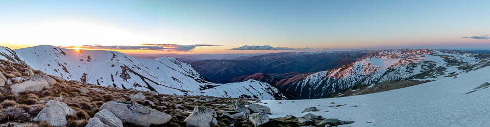
The views from the top were truly stunning looking towards the snow-capped Southern Alps and Mount Aspiring, and we were so lucky to have such a perfect day.
After lunch, it was time for the long descent. We were thankful for the panoramic views that kept us going.
Isthmus Peak is an outstanding day walk, and a must-do hike if you are near Wanaka, New Zealand. I prefer this walk to the more popular Roy’s Peak.
Wild Adventures Facebook Group
Trip Post
Clickable icons on this world map will open the related trip report
A detailed, searchable trip list with links to reports, photo galleries
The local landscape features, geology, scenic highlights, flora, fauna, Indigenous history, white history and other nearby walks in the area (Perplexity AI Model)
The Isthmus Peak Track traverses one of the most geomorphologically and culturally significant landforms in the South Island of New Zealand: The Neck (Te Kei), a narrow north–south isthmus separating Lake Hāwea to the east from Lake Wānaka to the west within the Upper Clutha basin, Otago. The track commences at the Isthmus Peak Track Carpark on State Highway 6 (the Makarora–Lake Hāwea Road), crosses Stewart Creek near the base of the route, and ascends through private pastoral farmland on Glen Dene Station before entering the Matatiaho Conservation Area at the upper ridge. The summit of Isthmus Peak stands at 1,385 metres above sea level, with approximately 1,000 metres of elevation gain over 8 kilometres from the trailhead.
Lake Hāwea lies at approximately 348 metres above sea level and Lake Wānaka at approximately 278 metres above sea level, separated by the narrow ridge through which this track passes. Both lakes rank among New Zealand’s largest: Lake Wānaka is the country’s fourth-largest lake and Lake Hāwea its ninth-largest. Their depths approach or exceed 380 metres, meaning the valley floors were scoured to below sea level by glacial action. The simultaneous panoramic view of both lakes from the summit of Isthmus Peak is among the most celebrated vistas in the Queenstown Lakes District.
Geomorphology and Glacial History
The landscape of The Neck and the surrounding Upper Clutha basin is the product of repeated Pleistocene glaciation. During the Last Glacial Maximum, two major valley glaciers — the Hāwea glacier and the Wānaka glacier — coalesced at the isthmus, their combined ice mass occupying the valley floors and extending south towards the Clutha River catchment. The U-shaped cross-sectional profiles of both lake valleys are clearly visible from the summit of Isthmus Peak and constitute classic examples of glacially over-deepened troughs. The valley floors were scoured to well below sea level, with Lakes Hāwea and Wānaka reaching depths of nearly 400 metres. Terminal moraines, deposited during successive glacial retreats, now dam the southern ends of both lakes, providing the natural impoundment that maintains their present water levels.
The track traverses steep, open pastoral and tussock terrain. In the lower section, the route follows the true right of Stewart Creek before joining a 4WD track and ascending the ridge via Dinner Creek and Dinner Flat. On reaching the ridge junction — a signposted T-intersection — walkers are directed right toward Isthmus Peak and left toward the Glen Dene Ridge Track and the Matatiaho Conservation Area.
Geology
The dominant bedrock across the region is Otago schist, a component of the broader metamorphic Haast Schist belt that forms the geological spine of the South Island. Sedimentation of the precursor sediments on the eastern margin of Gondwanaland commenced approximately 500 million years ago during the Cambrian to Permian periods. Subsequent subduction and crustal thickening drove progressive burial and metamorphism at temperatures exceeding 300 °C and depths greater than 10 kilometres, occurring between approximately 160 and 200 million years ago during the Triassic and Jurassic periods.
Post-metamorphic hydrothermal activity introduced wedges of silica-saturated superheated water along foliation planes, producing the characteristic inter-bedded quartz-schist layers visible in the ridgeline outcrops. These banded formations resemble a mille-feuille pattern and are a hallmark of Otago schist geology. Schist pinnacles — some resembling bishop’s mitres in profile — rise above the tussock grassland on the approach ridgeline. Gold mineralisation from hydrothermal solutions over the last 140 million years contributed to the broader Upper Clutha gold rush commencing in the 1860s.
Scenic Highlights
The summit of Isthmus Peak provides one of the few locations in New Zealand from which two large glacial lakes — Lakes Hāwea and Wānaka — can be viewed simultaneously from a single vantage point. The panorama extends westward across Lake Wānaka to the peaks of Tititea/Mount Aspiring National Park. To the north-east, the Hunter Valley and the ranges above Dingleburn Station are visible. On clear days, Mou Waho Island can be discerned within Lake Wānaka. The U-shaped glaciated valley profiles of both lakes are plainly evident from the summit, offering an outstanding field illustration of glacial geomorphology.
Local Flora
Vegetation on the Isthmus Peak Track reflects the altitudinal and edaphic gradients characteristic of the Otago inland ranges. The lower slopes support native forest and a transitional shrubland zone dominated by kānuka and mānuka (Kunzea ericoides and Leptospermum scoparium), with pittosporum (kōhūhū) shrubland present in the lower approach sections. Cordyline australis (tī kōuka) is present in lower valley areas. Higher elevations are dominated by tussock grassland communities, principally snow tussock (Chionochloa spp.) and hard tussock (Festuca spp.). Exposed schist rock faces support lithophytic communities typical of Otago rocky habitats, including native herbs and cushion plants. Speargrass (taramea, Aciphylla spp.) grows in exposed rocky areas on the upper ridges.
Local Fauna
Glen Dene Station operates as a working high-country farm and safari hunting station. Merino sheep (Ovis aries) graze throughout the lower farmland sections, well-adapted to the semi-arid climate and sparse tussock pasture. Red deer (Cervus elaphus), an introduced species, are farmed on the station, with trophy stag hunting occurring from March to May each year. The tussock and scrubland zones support abundant insect communities, including crickets and cicadas; the Matatiaho Conservation Area is noted for potentially unique entomological biodiversity. Native birds including kākā (Nestor meridionalis), kererū (Hemiphaga novaeseelandiae), and tūī (Prosthemadera novaeseelandiae) occur in forested areas, while the upper slopes and ridgeline support kea (Nestor notabilis).
Indigenous History
The isthmus of Te Kei (The Neck), together with the immediately adjacent lake shores and surrounding ranges, lies within the takiwā (tribal territory) of Kāi Tahu (also rendered Ngāi Tahu), the principal Māori iwi of Te Waipounamu (the South Island). Kāi Tahu whānui encompasses the ancestral peoples of Waitaha, Kāti Māmoe, and Kāi Tahu, whose whakapapa (genealogies) are intertwined through successive waves of settlement and intermarriage.
According to Waitaha oral tradition, the great lakes of Te Wai Pounamu — including Hāwea — were formed by the tūpuna (ancestor) Rākaihautū, captain of the waka (canoe) Uruao, who used his famous kō (digging tool) to excavate the principal lakes during his inland journey southward. The name ‘Hāwea’ derives from a tūpuna of the Waitaha hapū Ngāti Hāwea; the Waitaha descendant Rokotewhatu is said to have conferred the name, meaning ‘doubt’ — referring to his forebear’s indecision about which direction to travel when visiting the area.
Manuhaea, situated on the eastern side of The Neck immediately below the Isthmus Peak Track corridor, was a tribally renowned kāinga nohoanga (settlement) and kāinga mahinga kai (food-gathering place). It functioned as a central node in an extensive network of ara tawhito (traditional trails) connecting the West Coast via the Haast Pass (Tiori Patea), the Upper Clutha basin, the Waitaki catchment via Ōmakō (the Lindis Pass), and the coastal kāinga of Otago and Southland. Manuhaea was particularly noted as a rich tuna (eel) fishery; additional kai gathered there included weka, kākāpō, kiwi, kea, kākā, kererū and tūī, and gardens of potato, turnip, and kāuru (Cordyline root) were maintained.
In 1836, Te Pūoho led a Ngāti Tama war party from the West Coast via the Haast Pass through the area; Manuhaea was attacked and its inhabitants fled over Ōmakō to the Waitaki River, marking the final disruption of permanent Kāi Tahu occupation in the Upper Clutha interior. Seven papatipu rūnaka hold mana whenua over the region: Te Rūnanga o Moeraki, Kāti Huirapa Rūnaka ki Puketeraki, Te Rūnanga o Ōtākou, Hokonui Rūnanga, Te Rūnanga o Awarua, Waihōpai Rūnaka, and Te Rūnanga o Ōraka-Aparima. Statutory acknowledgement of these associations is enshrined in the Ngāi Tahu Claims Settlement Act 1998. In 1958, the damming of the Lake Hāwea outlet permanently submerged the Manuhaea lagoon and a portion of the 100-hectare fishery easement allocated by the Native Land Court in 1868.
European History
The first documented European to enter the Upper Clutha District was Nathaniel Chalmers in 1853, guided by Kāi Tahu chiefs Reko and Kaikoura. J. T. Thomson surveyed the region in 1857; James McKerrow produced the first accurate map in 1862; and John Connell surveyed and named the settlement of Lake Hāwea in 1863. European pastoral settlement commenced from the 1850s with large high-country run leases — the present-day Glen Dene Station occupies much of the western slopes of The Neck. The gold rush began in 1862 with discoveries in the Cardrona Valley and at Bendigo. Henry Hill established the first sawmill on Lake Hāwea’s shores in 1867; the Urquhart family settled near Dingle Creek in 1874; Richard Cayford opened the Panama Hotel at the Lake Hāwea outlet in 1881. The 1958 impoundment of Lake Hāwea raised the lake level by approximately 20 metres for the Roxburgh hydroelectric power station, permanently altering the shoreline ecology. The access easement across Glen Dene Station permitting public access to the Matatiaho Conservation Area was negotiated in 2008.
Clickable icons on this world map will open the related trip report
A detailed, searchable trip list with links to reports, photo galleries
![]()