
10/06/2026 – 12/06/2026 Whitehaven Beach South – Solway Circuit – South Whitehaven Beach Lookout – Solway Passage – Chance Bay Walk – Chance Bay – Nargo Track – Chance Bay Campsite – Theos Point Lookout – Bari Dhil Lookout – Camp 1: Bowarri yamba (Moon Camp) – Craig Point Lookout – Whitsunday Craig Lookout – Whitsunday Craig – Bilbili dhilli Lookout – Crayfish Bay Lookout – Camp 2: Dhula yamba (Tree Camp) – Torres Herald Bay – Gumi – Murmuru bari Lookout – Hill Inlet Lookout Platform – Bettys Beach – Tongue Point
Ngaro Track
Whitsunday Islands National Park, QUEENSLAND
Ngaro Country (Ngaro people)
Distance: 35.7km Total Ascent: 1495m Total Descent: 1463m
Time: 18 hours
Participants: Matt Aistro, James Anthony, Stephen Davies (Photos), Sue Davies (Report), Katie, Cecelia McLoughlin, Matt Madin, Rachel, Kylie Shirvington, Philip Whitmore, Summer and River [15 altogether]
Three unforgettable days on the Ngaro Track delivered everything you could want from a Whitsunday Islands adventure—wild weather, sweeping island vistas, rich cultural landscapes, and a constantly changing mix of coastal and forest environments. Starting with a rough, rain-soaked boat ride to the dazzling white sands of Whitehaven Beach, this journey quickly set the tone for a challenging and rewarding trek across Ngaro Country.
Covering 35.7 km with significant elevation gain, the track links secluded bays, panoramic lookouts, ancient hoop pine forests, mangrove wetlands, and pristine beaches. Each day revealed something new—from ridge-top camps overlooking turquoise waters to close encounters with remarkable wildlife. Shared with a great group of walkers, this hike was as much about camaraderie as it was about the landscape, with every step offering another reason to pause, photograph, and take it all in.
Day 1: Wednesday 10/06/2026 Whitehaven Beach South – Solway Circuit – South Whitehaven Beach Lookout – Solway Passage – Chance Bay Walk – Chance Bay – Nargo Track – Chance Bay Campsite – Theos Point Lookout – Bari Dhil Lookout – Camp 1: Bowarri yamba (Moon Camp)
Ngaro Track
Whitsunday Islands National Park, QUEENSLAND
Ngaro Country (Ngaro people)
Max elevation: 129 m
Total climbing: 363 m
Total descent: -271 m
Average speed: 3.15 km/h
Total time: 04:34:30
It was an early start as we needed to be at Shute Harbour by 6:30am. We had worked out the bus system the previous day, and we could arrive on the first bus of the day at 6:27am. It was a bargain at 50 cents per person compared to $54 for a taxi.
We arrived on time, and the Scamper crew (our “water taxi”) was keen to get going asap to beat the tide. We were quickly checked in and were motoring by 6:40am!
The rain had started earlier, and it was quite heavy as well as windy, so we were in for a wild ride. I didn’t realise how spine-crushing it would be.
There were 21 passengers on the flat-bottomed boat, along with all our backpacks, the eskies, and supplies for the Argentinian campers who missed out on leaving the day before.
It was very rough at times, and it also rained heavily at times. The boat would suddenly drop and slam back onto the water, and you could feel the force go through your body. We were hanging on for dear life! The multiple boxes of camping supplies stacked on the floor of the boat were unsecured and dangerous in these conditions.
After about 80 minutes of this torture, we arrived at Whitehaven Beach. As we disembarked, we were given instructions on how to brace ourselves in the conditions. It would have been helpful to know this when we started!

Whitehaven Beach
The white sands and azure water were stunning and backed by ominous clouds, it was quite a sight. We climbed up to the lookout for some lovely views over the beach and surrounding bays.
We walked back to our packs to start the walk proper. After about 2km of walking through the bush, we arrived at the clear waters of Chance Bay. After a short beach walk, we headed back into the bush, stopping at several viewpoints along the way, Theo’s Point and Bari dhili (rock eye). It was just a short stroll to our camp for the night at Bowarri yamba.
The campsites have great facilities, including toilets with a fantastic view. This site is situated on a ridge overlooking the stunning waters of Silica Bay.

View across Crano Cove from Bowarri yamba (Moon Camp)
We relaxed and chatted getting to know our fellow walkers. After an early start, we managed to stay awake until 8:00pm!

Day 2: Thursday 11/06/2026 Camp 1: Bowarri yamba (Moon Camp) – Craig Point Lookout – Whitsunday Craig Lookout – Whitsunday Craig – Bilbili dhilli Lookout – Crayfish Bay Lookout – Camp 2: Dhula yamba (Tree Camp) – Torres Herald Bay
Ngaro Track
Whitsunday Islands National Park, QUEENSLAND
Ngaro Country (Ngaro people)
We enjoyed watching the sunrise as we had breakfast and morning coffee. We headed off around 8:30am, one of the last to leave camp.
Initially, we descended through a pine forest, mainly ancient hoop pine. It was quite steamy, and it started raining, and we were thankful for the relief!

Sue on Ngaro Track before Whitsunday Craig Lookout
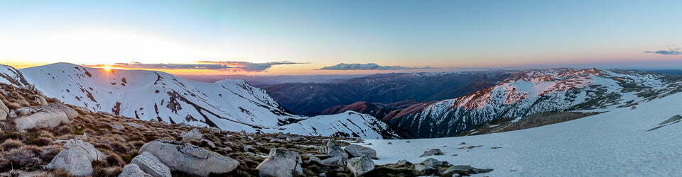
There would be numerous lookouts today with panoramic views over the Whitsunday Islands. The first was Crag Point Lookout, followed by a climb up to Whitsunday Craig Lookout. There were steep steps to climb, which were clearly designed by a tall person. A chain was available to hold across a rocky section. Care was needed as some of the rocks were slippery after the rain.

View from Whitsunday Craig Lookout
At Crayfish Bay, we had a direct view across to Hamilton Island with the high-rise apartments which really looked out of place in this stunning natural environment!

Coastal Carpet Python (Morelia spilota ssp. mcdowelli) before Crayfish Bay Lookout
We were told that we had missed a large python that was resting on the side of the path. We retraced our steps and saw this stunning creature. Its skin is really an artwork.
After lunch, we continued on a further 2.8km before reaching our campsite for the night on the beach at Torres Herald Bay.
Day 3: Friday 12/06/2026 Torres Herald Bay – Camp 2: Dhula yamba (Tree Camp) – Gumi – Murmuru bari Lookout – Hill Inlet Lookout Platform – Bettys Beach – Tongue Point
Ngaro Track
Whitsunday Islands National Park, QUEENSLAND
Ngaro Country (Ngaro people)
Max elevation: 112 m
Total climbing: 472 m
Total descent: -456 m
Average speed: 3.24 km/h
Total time: 06:45:53
We awoke early, as had been the pattern on this trip. The shelter lights up at 5:00am, so breakfast was soon after. Today was our longest day, and we needed to be at the end to meet the boat at 4:00pm so we hit the track at around 7:30am.
Again, it was steamy after overnight rain, but thankfully, most of the trail offers decent shade.
The trail crossed a beautiful mangrove area, and we were thankful that a boardwalk was provided. Then we walked through the Gumi pond’s wetlands and some very dense vegetation, which blocked out most of the light.

Forest past Gumi
About halfway along today’s route, we reached the only side strip of the day to Mumuri bari (Round Rock). This was only a 1.2km diversion, but the views of the upper inlet were sensational.
Returning to the trail, we continued in search of a lunch stop. We eventually found a spot in the shade, but there were some mozzies around, so we didn’t linger.
It was a real treat reaching the Hill Inlet lookouts for the stunning views of the swirling, brilliant sands of Whitehaven Beach and the expansive inlet. We ventured down the Bay side but then returned to the beach for our boat pick up.

Hill Inlet and Whitehaven Beach from Hill Inlet Lookout
We all made it; for some, it was easier than for others, and everyone had a story to tell. We had a great group of people to enjoy this adventure with. Special mention goes to young 4-year-old River, who walked the track with his parents, and we didn’t hear a word of complaint from him over the 3 days. What a champion!
Amongst other photographically recorded observations during this walk, we were able to confirm sightings of each of the following species: Cinnabar Bracket (Trametes sanguinea), Purple Crow (Euploea tulliolus), Maybe Funnel Woodcap (Lentinus sajor-caju), Green Tree Ant (Oecophylla smaragdina), Beach Myrtella (Lithomyrtus obtusa), Maybe Oakleaf Fern (Drynaria quercifolia), Blue Umbrella (Mackinlaya macrosciadea), Green Jumping Spider (Mopsus mormon), Orangepetal Passionflower (Passiflora aurantia), Maybe Forest Grasstree (Xanthorrhoea johnsonii), Maybe Sabdariffa divaricata, Maybe Drynaria sparsisora, Coastal Carpet Python (Morelia spilota ssp. mcdowelli), Maybe Yellow Stemmed Micropore (Microporus xanthopus), Maybe Phellinus everhartii, Maybe Coastal Grasstree (Xanthorrhoea latifolia), Maybe Tree Heliotrope (Heliotropium arboreum), Coral Rock Oyster (Saccostrea scyphophilla), Maybe Funnel Woodcap (Lentinus sajor-caju), Maybe Solitaire Palm (Ptychosperma elegans), Forest Grasstree (Xanthorrhoea johnsonii), Maybe Basket Fern (Drynaria rigidula), Maybe Sabdariffa divaricata, Orangepetal Passionflower (Passiflora aurantia), Lace Monitor (Varanus varius), Maybe Eight-armed Luidia (Luidia maculata), Light-blue Soldier Crab (Mictyris longicarpus)
Wild Adventures Facebook Group
Clickable icons on this world map will open the related trip report
A detailed, searchable trip list with links to reports, photo galleries and other content
From Whitsunday Island National Park “Pathfinder” App
Nargo track
Day 1: Whitehaven Beach South – Camp 1: Bowarri yamba (Moon Camp)
Arrive by boat at the southern end of Whitehaven Beach, with an option to visit the Whitehaven Beach lookout. Continue along the shared track to Chance Bay to the begin the Ngaro track. The trailhead is located 100m beyond the Chance Bay camping area and offers informative signs, seating and photo opportunities. Along the way you will pass Theos point and Bari dhili (Rock eye) viewpoints offering photo opportunities and Ngaro family art installation posts.
Finish at Camp site 1 – Bowarri yamba (Moon camp), perched atop an imposing ridgeline overlooking picturesque Silica Bay
Day 2: Camp 1: Bowarri yamba (Moon Camp) – Camp 2: Dhula yamba (Tree Camp)
Day 2 begins from Bowarri yamba (Moon Camp), with the trail climbing steadily toward Whitsunday Craig, reaching 353 metres above sea level. Ladders and stairs guide you to the summit, where sweeping views over isolated island bluffs and headlands make the effort worthwhile. Pause at Lower Craig and Crayfish Bay for photo-worthy lookouts and to reflect on Ngaro family art installations that share cultural storylines.
The day ends at Dhula yamba (Tree Camp), nestled in the peaceful beach surrounds of Torres Herald Bay
Day 3: Camp 2: Dhula yamba (Tree Camp) – Tongue Point
Day 3 sets off from Dhula yamba (Tree Camp), beginning with a walk through the Whitsundays’ only mangrove boardwalk and past the tranquil Gumi (Ponds) wetland. Along the way, enjoy views from Murmuri bari (Round Rock) and Upper Inlet, both home to cultural art installations and scenic photo stops.
Mark your achievement at the Ngaro track photo post, before reaching the spectacular Hill Inlet lookouts, where the swirling sands of Whitehaven Beach unfold below. The journey ends with a boat departure from Tongue Bay, completing your walk through Ngaro Country.
Information on Parks signage along the way
A walk through World Heritage
The Ngaro track is a 32km one-way, hiking adventure from Whitehaven Beach to Tongue Point. Walk through sun-dappled eucalypt woodlands, sections of shady rainforest and mangroves. Climb up Whitsundays Craig with spectacular views along the way.
Welcome to Ngaro Country the islands, sea and sky of this place
We are proud sea people, and our Country is part of the Birri Gubba Nation of Aboriginal Australia.
Today we continue to share in the language and traditions of our close Biri neighbours and extend our greeting to you, Wadda Mooli.
WHITSUNDAY – NGARO SEA TRAIL
Follow in the footsteps of the Ngaro people while exploring Whitsunday Island’s forests, rocky outlooks, bays and beaches.
Chance Bay – Whitehaven Beach track
4.6km return. Allow 2-2.5hr.
A wonderful stroll through towering Mackay cedars and, if you’re quiet, a chance to hear and see some of the elusive wildlife.
Chance Bay – Headland – Whitehaven Beach track
6.4km return. Allow 3.5-4.5hr.
Take a detour to Whitehaven’s superb viewpoints.
Get a closer look at Solway Passage and further out to • the many other islands that make up ‘The Whitsundays’ as well as a stunning view of Whitehaven Beach.
Welcome to Camp site 1: Bowarri yamba (Moon camp)
The Ngaro People have been connected to this landscape for thousands of years. They ask that you treat the area with care and respect.
Protect culturally and ecologically sensitive sites along the Ngaro track by staying on the track.
Walking from here (Day 2) to Camp site 2: Dhula yamba (Tree camp)
10.5km one way, allow 6hr
Moderate to hard hiking
Welcome to Camp site 2: Dhula yamba (Tree camp)
The Ngaro People have been connected to this landscape for thousa of years. They ask that you treat the area with care and respect.
Protect culturally and ecologically sensitive sites along the Ngaro track by staying on the track.
Walking from here (Day 3)
To Hill Inlet lookouts, Tongue Point 12.7km, allow 7hr
Moderate to hard hiking
How mangroves manage
This 170m inlet and mangrove crossing is near the island’s South Coast. Here dense mangroves and fragile samphire dominate a remote and harsh environment. Stay on the boardwalk to enter a remarkable world where animals and plants have adapted to survive.
Remember to be Shark Smart and Crocwise in the Whitsundays!
Propping up the ecosystem
Prop roots and pneumatophores-snorkel-like, breathing roots-not only give the mangroves support and oxygen, but also trap mud and silt. This is a vital lifelayer of a mangrove ecosystem. Many mud dwellers live out their lives here adding to the nutrients which cycle back into the plants.
Mangroves love living here!
Their special roots draw food from sea water and the salt-soaked mud.
Their seeds are shaped to fall and float to new grounds.
Their leaves produce food for the plant, get rid of excess salt and eventually die, fall and rot back into the mud.
Not too much salt please
Some mangroves, like the grey mangroves Avicennia marina seen around here, and the river mangroves Aegiceras corniculatum, are salt excreters. They get rid of excess salt through leaf glands. Turn over a leaf of a grey mangrove and see for yourself.
The smaller yellow mangroves Ceriops tagal are salt excluders. Roots filter out salt as they take in sea water.
The local landscape features, geology, scenic highlights, flora, fauna, Indigenous history, white history and other nearby walks in the area (Perplexity AI Model)
Landscape features
The Ngaro Track traverses the eastern spine of Whitsunday Island, linking high ridges, deep saddles and a series of indented bays and inlets that typify this drowned‑river archipelago. The route progresses from the broad, gently curving arc of Whitehaven Beach South, with its fine white sand and low foredunes, into increasingly rugged terrain where steep slopes rise to narrow crests such as Whitsunday Craig. Along its length, the track alternately hugs sheltered bays—Chance Bay, Silica Bay, Torres Herald Bay—and climbs to lookouts that command extensive views over the surrounding islands, headlands and channels, including Solway Passage and Hill Inlet.
Geology
Whitsunday Island forms part of the Whitsunday Group, a cluster of islands derived from ancient volcanic and intrusive rocks that have been uplifted and dissected over geological time. Resistant bedrock underlies the steep, forested ridges and cliffs that frame the Ngaro Track, while weathering and erosion have produced thin, stony soils on exposed slopes and slightly deeper, more developed profiles in gullies and lower benches. Post‑glacial sea‑level rise flooded former valleys, creating the present pattern of bays and passages; Whitehaven’s famously bright sand reflects a high proportion of silica, reworked by waves and currents into an even, fine‑grained surface that contrasts strongly with darker, more mixed sediments elsewhere.
Scenic highlights
Scenic interest is both continuous and episodic along the Ngaro Track, with major viewpoints punctuating enclosed forest sections. Early in the walk, the Solway Circuit and South Whitehaven Beach Lookout provide commanding views over Solway Passage and the southern Whitsundays, illustrating the relationship between coastal landforms and offshore reefs. Further north, Craig Point, Whitsunday Craig, Crayfish Bay and Murmuru bari lookouts offer panoramas of island-studded seas, abrupt headlands and distant horizons, while the final approach to Hill Inlet Lookout platforms culminates in an iconic vista of swirling white sand and turquoise water that has come to symbolise the region internationally.
Local flora
Vegetation along the Ngaro Track reflects strong gradients in exposure, soil depth and moisture. Lower slopes and sheltered gullies support relatively tall eucalypt and hoop pine forest with a multi‑layered understorey of shrubs, ferns and ground covers, creating shaded, humid microclimates that can feel markedly cooler than adjacent ridges. As the track gains height, canopy cover becomes more open and species assemblages shift towards dry, wind‑pruned woodland and heath, with plants displaying sclerophyllous leaves, low growth forms and other adaptations to high light, salt‑laden winds and periodic water stress. In coastal fringes and around bays, forest grades into communities tolerant of saline influence, while mangrove and samphire vegetation occupies intertidal flats at Gumi and other wetland sites.
Local fauna
The near vicinity of the track provides habitat for a diverse fauna typical of tropical coastal islands. Forested sections support a rich bird assemblage, from large, conspicuous species such as kookaburras and cockatoos to smaller, more cryptic birds that move rapidly through the shrub layer and canopy. Reptiles, including large snakes and monitors, utilise the structural complexity of rocky slopes, fallen timber and leaf litter, while small mammals and invertebrates occupy a range of niches extending from dry ridge crests to moist gullies. Intertidal zones near Chance Bay, Silica Bay, Torres Herald Bay and Hill Inlet add further diversity, with crabs, molluscs and other shore organisms exploiting the interface between land and sea.
Indigenous history
The Ngaro Track is explicitly situated within Ngaro Country, and its route, interpretive material and naming conventions foreground the long‑standing cultural relationship between the Ngaro people and this seascape. As maritime people within the broader Birri Gubba Nation, the Ngaro developed sophisticated knowledge systems for navigating, fishing and seasonal resource use across the islands and adjoining sea country. Contemporary installations and place names along the track—such as Bowarri yamba, Dhula yamba, Bari dhili, Murmuru bari and the Ngaro track photo posts—are designed to acknowledge that the ridges, bays and lookouts now visited for recreation are also story places, travel routes and living cultural sites whose significance extends far beyond their scenic appeal.
White history
Non‑Indigenous engagement with the Whitsunday islands intensified during the nineteenth century through exploration, maritime industries and pastoral ventures, followed in the twentieth century by rapid growth in tourism centred on nearby mainland ports and resort developments. Management of the islands as protected areas under the Whitsunday Islands National Park has increasingly emphasised conservation and nature‑based tourism, framing experiences such as the Ngaro Track as opportunities to encounter World Heritage‑listed natural values. The recent development of this multi‑day walk, associated campsite infrastructure and interpretive program reflects an evolving model in which recreational access, environmental protection and recognition of Ngaro cultural authority are negotiated within a single, high‑profile walking product that attracts domestic and international visitors.
Clickable icons on this world map will open the related trip report
A detailed, searchable trip list with links to reports, photo galleries and other content
![]()
Great work. A very impressive post. Lovely photos. it was a very nice group of people. Well done, Steve.