
Monday 16/03/2026 Stewart Island Backpackers – Elgin Terrace – Mill Creek – Horseshoe Bay Road – Butterfield Beach – Horseshoe Point Road – Horseshoe Bay Beach – Horseshoe Point – Simons Beach – Sarah Cove – Braggs Bay Road – Braggs Bay – Moturau Moana Native Gardens
Oban – Half Moon Bay – Horseshoe Point
Stewart Island / Rakiura
Southland Region, NEW ZEALAND (Aotearoa)
Rakiura Country (Ngãi Tahu people)
Participants: Stephen Davies (Photos), Sue Davies (Report)
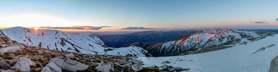
We set off from the Stewart Island Backpackers in Oban on a cool March morning with scattered showers and a brisk south-westerly — typical Stewart Island weather. The route climbs out past Mill Creek and along Horseshoe Bay Road, the houses thinning as the road rises. It’s straightforward roadside walking with a steady gradient — this island is anything but flat. The views of the coast opened up nicely, with Butterfield Beach curling around below and Horseshoe Point in the distance.
Max elevation: 49 m
Total climbing: 340 m
Total descent: -352 m
Average speed: 3.41 km/h
Total time: 04:13:21
From Bragg Bay, the Horseshoe Point Track takes over — a well-formed but muddy undulating path threading along the clifftop above Frenchman’s Beach, Simons Bay and Sarah Cove. Short, steeper pinches add a touch of exertion, but it never feels exposed or technical. The bush along the route is rich and lush, dripping with ferns and native growth after the passing showers. We saw Sacred Kingfishers (Todiramphus sanctus) and New Zealand Fantails (Rhipidura fuliginosa) along the track, and a Variable Oystercatcher (Haematopus unicolor) on the beach below.

Sacred Kingfisher (Todiramphus sanctus) at Mill Creek
At Horseshoe Point the world opens out to the restless sweep of Foveaux Strait. A detour via Moturau Moana Native Gardens on the return — terraces above Halfmoon Bay with native plantings and a lookout deck — was a highlight. A rewarding day walk around the southern edge of Halfmoon Bay. Rakiura is a special place.
Amongst other photographically recorded observations during this walk, we were able to confirm sightings of each of the following species: Variable Oystercatcher (Haematopus unicolor), New Zealand Fantail (Rhipidura fuliginosa), Sacred Kingfisher (Todiramphus sanctus), Ray Water-Fern (Cranfillia fluviatilis), Sacred Kingfisher (Todiramphus sanctus)
Wild Adventures Facebook Group
Trip Post
Clickable icons on this world map will open the related trip report
A detailed, searchable trip list with links to reports, photo galleries
The local landscape features, geology, scenic highlights, flora, fauna, Indigenous history, white history and other nearby walks in the area (Perplexity AI Model)
Landscape features
The immediate landscape around this route is a compact expression of Stewart Island’s deeply indented northern coastline, with a chain of small bays, low headlands and short, steep catchments running down from the settled ridge above Oban to the sea. Halfmoon Bay and Horseshoe Bay form broad, sheltered curves, while Butterfield Beach, Bragg Bay, Frenchman’s Beach, Deadmans Beach in Simons Bay and Sarah Cove are smaller pockets of sand and rock tucked beneath forested slopes. The Horseshoe Point Track occupies the transition zone between coastal terrace and sea cliffs, with repeated descents to beaches and rises to low viewpoints over Foveaux Strait. Moturau Moana Native Gardens sit on a gently sloping spur above Bragg Bay Road, providing a deliberate vantage over Halfmoon Bay and the scatter of offshore rocks such as Bragg Nugget. Overall, the setting is intimate rather than grand, but the constant interplay of forest, shore and open water creates a highly varied micro‑landscape along a relatively short distance.
Geology
Stewart Island is part of the broader Southland geological province, dominated by ancient metamorphic and igneous rocks that continue the structure of the South Island’s basement beneath Foveaux Strait. Around Halfmoon Bay and Horseshoe Bay, this hard basement forms low headlands and resistant points, controlling the shape of the bays and providing firm foundations for the coastal terraces followed by the track. Weathering and marine erosion have created short, steep gullies that drain to the sea and confine the beaches in narrow pockets between rocky spurs. At Bragg Bay, Frenchman’s Beach and Deadmans Beach, coarse sand and rounded gravels accumulate where wave energy is moderated by the enclosing headlands and the offshore islets of Halfmoon Bay, including Bragg Nugget. The result is a shoreline where relatively modest relief is amplified by sharp contrasts in slope and substrate over very small distances, a key factor in the dense pattern of small bays encountered along the walk.
Scenic highlights
Several points along this route offer particularly striking views that anchor the visual experience of the walk. From Moturau Moana, a wooden viewing deck looks out across Halfmoon Bay to the surrounding hills and offshore rocks, framing Oban within an almost amphitheatre‑like setting of forest and sea. The Horseshoe Point Track itself repeatedly reveals sudden glimpses of crystal‑clear water and pale sand at Bragg Bay, Frenchman’s Beach and Deadmans Beach, where the contrast between dark forest, white shore and turquoise shallows is especially pronounced in clear weather. Horseshoe Point provides the broadest outlook, opening north and east across Horseshoe Bay and out to Foveaux Strait, with the curvature of the bay emphasising the sense of standing on a true point at the edge of the island. Even the road sections along Horseshoe Bay Road contribute to the scenic experience, offering long, unfolding views of the bay as the route climbs away from Oban and then descends again toward the beaches.
Local flora
Moturau Moana Native Gardens were established in the 1930s as a showcase of New Zealand native plants and today represent a curated but mature expression of the island’s coastal flora. Within and around the gardens, visitors encounter a dense canopy of southern coastal forest, including tree ferns, broadleaf species and conifers characteristic of the cool, wet Southland climate. Along the Horseshoe Point Track, this forest becomes less formal and more representative of natural coastal bush, with a layered structure of tall trees, understorey shrubs and a thick ground cover that spills down the slopes almost to the high‑tide line. The track’s frequent transitions between open bays and enclosed forest emphasise how quickly coastal vegetation responds to changes in exposure and drainage, with more stunted growth on the points and lusher, taller forest in sheltered gullies. Moturau Moana, as the southernmost public garden in New Zealand, also has historical significance as an early attempt to conserve and interpret native flora for visitors in a remote setting.
Local fauna
Stewart Island is renowned for its birdlife, and even a relatively short walk around Oban offers exposure to this richness. The coastal forest and gardens support a range of forest birds, while the adjacent shoreline and bays host sea birds that patrol the edge of Foveaux Strait. The broader island holds New Zealand’s largest concentration of brown kiwi, and while dedicated night excursions usually target more remote coves, the general area around Halfmoon Bay forms part of this wider habitat mosaic. Marine mammals, including seals and sea lions, are regularly recorded around Stewart Island’s coasts, and the exposed outer points such as Horseshoe Point provide vantage sites from which these animals and passing seabirds can be observed. Collectively, the route sits within an island‑scale conservation landscape where native fauna are a central focus of both management and visitor experience.
Indigenous history
Rakiura lies within the takiwā (tribal area) of Ngāi Tahu, whose history on the island stretches back many generations and is entwined with wider traditions connecting the South Island and its outlying islands. Oral traditions describe Rakiura as Te Punga o Te Waka o Māui, the anchor stone of the demigod Māui’s canoe, situating the island within a mythological seascape that extends across the entire country. Place‑names such as Rakiura, meaning “glowing skies”, speak to long familiarity with the southern lights and the distinctive qualities of the local environment. In the nineteenth century, the Rakiura Deed of 1864 formalised Crown acquisition of the island from Ngāi Tahu signatories, reshaping land tenure while leaving enduring cultural associations with bays, headlands and resources around Halfmoon Bay and Horseshoe Bay. Contemporary recognition of this history appears in dual naming (Stewart Island / Rakiura) and in the ongoing role of Ngāi Tahu as treaty partners in the governance of conservation areas such as Rakiura National Park.
White history
European involvement with Stewart Island intensified from around 1800 with sealing and whaling, followed by more permanent settlements around sheltered harbours such as Halfmoon Bay. The town of Oban developed as the principal service centre, its streets, wharf and accommodation—today including Stewart Island Backpackers—clustered close to the shoreline. The creation of Moturau Moana in the 1930s by Noeline Baker, and its gifting to the Crown in 1940 as a botanical research station, illustrate early twentieth‑century conservation and scientific interests on the island’s accessible northern fringe. Over time, extensive tracts of the island were incorporated into Rakiura National Park and related reserves, with management focusing on biodiversity protection, pest control and the development of a modest but significant walking network, including the Horseshoe Point Track and associated short walks around Oban. Today, tourism centred on nature, walking and wildlife viewing has become a major component of the local economy, with short coastal walks such as this one providing a readily accessible introduction to the island’s environmental and historical context.
Clickable icons on this world map will open the related trip report
A detailed, searchable trip list with links to reports, photo galleries
![]()