
Monday 16/10/2023 Halls Gap Holiday Park – Grampians Road – Wonderland Loop Walk – Stony Creek – Venus Baths – Splitters Falls – Wonderland Carpark – Turret Falls – Grand Canyon – Cool Chamber – Silent Creek – The Pinnacle – Gate of the West Wind – Relf Peak – Halls Gap to Pinnacle Track – Mackays Peak
Grampians National Park, VICTORIA
Gariwerd Country
Participants: Stephen Davies (Photos, Report), Sue Davies
With a longer walk planned for the day, we walked out of Halls Gap Holiday Park at 9:40am following the Grampians Road to the Botanic Gardens. Walking quickly through the gardens we followed the well-formed yellow, crushed stone Wonderland Loop Walk along Stony Creek. This passed through a low forest with heath in flower and other wildflowers. There were also views of the colourful walls and slopes of surrounding sandstone hillsides.
Max elevation: 697 m
Total climbing: 1097 m
Total descent: -1098 m
Average speed: 3.40 km/h
Total time: 06:50:48
Just after a footbridge, we reached an open section of Stony Creek flowing across bedrock. This forms a nice pool called Venus Baths.
From Venus Baths the track continues for another 2.7km up to Turret Falls, all the while providing changing views of the high neighbouring sandstone slopes and adjacent forest. There are also many spots with close creek views and an endless array of wildflowers alongside the track. The final climb to the falls involves rock steps, some rock hopping and several water crossings. Turret Falls itself is a multi-braided multi-level drop and today had enough water flowing over it to make it look interesting. After heavy rain, it would be really spectacular. The damper area surrounding its plunge pool supports a lot of ferns.
Now backtracking from the falls to Wonderland Carpark we drop back down and across Stony Creek over a footbridge. Now two hours into our walk we were at the start of the Grand Canyon Loop.
Today the Grand Canyon Loop was closed, as it appeared a large slab had collapsed and fallen onto the track just before the stairs at the far end. This section was fenced off. We ventured as far in as we could, taking in the beauty of the small, deep, rugged sandstone walls now surrounding us. The walk-in included some massive stepping stones across the creek and a section along a bedrock ledge between stony tracks, lots of this would get very slippery when wet. It is surprising that it is named “The Grand Canyon”, having visited its famous namesake this is a very minor canyon but with its own beauty all the same. Perhaps an indigenous name would be more appropriate.
Continuing to climb through rocky woodland past the Grand Canyon we reached a cave entrance called Cool Chamber. Following this is Bridal Veil Falls, a small waterfall that you can walk behind since it drops from an overhang. Not much further up the hill, we walked through Silent Street, a long, narrow, very straight gully between two vertical walls of highly eroded sandstone. At one point this is only shoulder width and for most of its length, a stony path has been made. It should be noted that a little further afield there was a never-ending display of intriguing, highly textured shapes of weathered sandstone cliffs and pedestal-style formations.

Silent Street
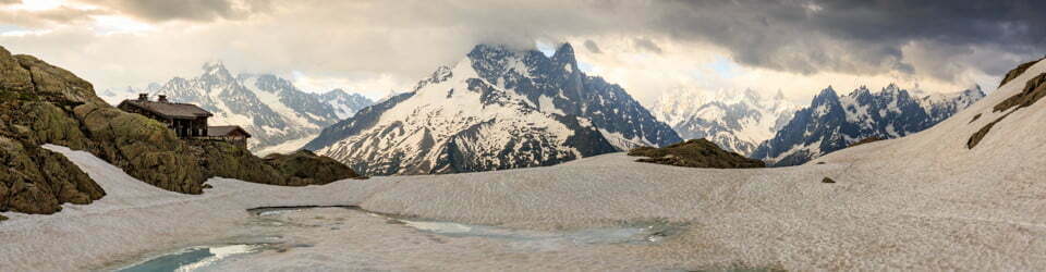
Now for the last 50m vertical to climb to reach The Pinnacle and Pinnacle Lookout at 715m. From here there are magnificent views to the north of Point Sunshine and Halls Gap below. Just to the south Bellfield Peak makes a big impression with its jagged edge dominating the view.
After backtracking about 50m from the lookout a track junction to the right leads back to Halls Gap along The Pinnacles Track. This follows the ridge to the north, passing to the immediate west of the Gate of the Wind and Relph Peak about 300m from the last junction. From there the long descent begins, at first gently before veering off to the east and descending as it crosses the slope beneath Point Sunshine, which forms a foreboding wall above. There are some great views across to the east during the descent. At one point you pass down a rocky gully through a stringy bark forest with grass-trees and Pine Heath. Soon after passing Mackays Peak the track descends much more steeply and a lot of steel mesh steps are in place to ease the effort, without the aid of hiking poles as the tips tend to get caught in the mesh repeatedly. Although there is a short sidetrack to Mackays Peak, we skipped it today.
The track finally rejoins the Wonderland Loop Walk near the bottom before emerging at the Grampians Flora Botanic Gardens. From here, we still needed to walk back along Grampians Road to get back to our campsite.
This is a sensational day walk. There seems to be an almost never-ending variety in the scenery, with the varied geological features being a stand out. The wildflowers are also fabulous. After good rainfalls Stony Creek would also be flowing strongly and the waterfalls would be at their best.
Parks Victoria signage along the way
During the last 170 years since Charles Hall explored this gully, more people have passed through this area than any other place in the Grampians.
Just beyond here is *Venus Baths, a place to cool your feet on a hot day, to relax with the sound of a gentle breeze or to contemplate the marvels of an ancient land. It is a place which clearly shows evidence of Nature at work.
Wind and rain over millions of years have carved the sandstone rock into weird and wonderful shapes. Early settlers in the Fyans Valley were so fascinated with the rock sculptures that they named the area between Stony and Dairy Creeks, Wonderland Range. The rock slab above you was called Elephant’s Hide, a name that is most realistic when it is wet and seen under leaden skies. At the southern end of Wonderland, another one of many names given to rock features is Sundial Peak, where the rising sun first strikes the range.
In a landscape of change, wind, fire and flood have shaped and altered the Grampians for millions of years. One thing is certain Nature will continue to alter Hall’s “wild romantic glen” for many, many more years to come.
*Venus Baths is the name for this site, adapted from the early 20th century name for the largest pool, Venus’ Bath.
From Grampians National Park Visitor Guide
From Grampians National Park Signs
Halls Gap – A central stepping stone
Welcome to Grampians National Park (Gariwerd), famous for its rugged mountain peaks, spectacular scenery, seasonal waterfalls and ancient Aboriginal Rock Art.
This ancient rugged landscape of Gariwerd, holds a diversity of experiences and mystery within its magnificent sandstone ranges.
The choice is yours. Whatever your interest or capability, the park abounds with opportunities for seeing spectacular scenery, wildflowers, and native animals. Kangaroos, emus, gliders and echidnas are common in the park, although some may be difficult to locate. The park is also home to over 200 species of birds. Gariwerd has a diverse and rich human history and is renowned for its very important indigenous sites and places.
Here is a small range of walks, and all start from Halls Gap. For further walking, road and park information on the Grampians National Park visit Brambuk – The National Park & Cultural Centre in Halls Gap.
Venus Baths Loop
A shady stroll to rockpools
Distance: 2.3km circuit Time: 30 minutes – 1.0 hour
Grade: Easy Elevation Change: 50 metres
Start: Carpark opposite shops in Halls Gap.
Walk through the carpark, past the swimming pool and cross the sealed road.
Follow the track and cross the pedestrian bridge to the right, over Stony Creek to the Botanic Gardens. The track winds along the creek and past some towering sandstone cliffs. The delightful Venus Baths rockpools are just beyond a foot-bridge. Return to Halls Gap by the same route or cross the foot-bridge and follow the track on the opposite side of the creek.
The Pinnacle via Mackey’s Peak
This strenuous walk involves many steep staircases, rock steps and slippery track surfaces
Time: 4.0 hours Distance: 6.2km
Grade: Hard Elevation change: 470m
Start: Halls Gap Caravan Park
From the rear of Halls Gap Caravan Park (Agnes’ Grave) follow the walking track to the base of a large staircase. A steep climb through heathy forest takes you up the front of Mackey’s Peak via many staircases. The track then winds its way up through rocky outcrops before arriving at the Pinnacle Lookout. Enjoy views over Fyans Valley. Return via the same route.
Boronia Peak
A rocky peak and breathtaking views
Time: 2-3 hours Distance: 6.6km return
Grade: hard Elevation Change: 300m
Start: Tandara Road, off Grampians Road
Cross Fyans Creek Footbridge and begin a steady climb through tall messmate forest and native pines, along the western slope of Mt William Range. A scramble up the rocky summit rewards you with superb views towards Lake Fyans and over the Fyans Valley. Return via the same route.
Wonderland Loop
Suitable for fit and energetic walkers
Elevation Change: 400m Grade: medium to hard
Start: Carpark opposite shops in Halls Gap.
Walk through the carpark, past the swimming pool and cross the sealed road.
Follow the well formed track to Venus Baths. The rocky track continues to Splitters Falls then to the Wonderland Carpark Cross the footbridge into the spectacular Grand Canyon. A the top of the steps, turn left and follow the signs up the rock platforms. The steady ascent winds through rocky woodland, past Bridal Veil Falls (best after rain), through Silent Street and on to the awe inspiring Pinnacle Lookout. Return 50 metres to the track intersection, follow the signs by veering right over the rock slabs. The track decends along the ridgeline, down a rocky gully through a stringybark forest with grass-trees and Pine Heath. The track steepens and winds along the Wonderland Range to the Halls Gap Caravan Park.
Chatauqua Peak Loop
Peaks and wet weather waterfalls
Time: 2.0 to 3.0 hour circuit Distance: 5.6 km
Grade: Medium Elevation Change: 200km
Start: Recreation Oval Carpark, behind the Police station on the Mt Victory Road
From the recreation oval, follow the signposted track through open forest to the foot of Clematis Falls (best after rain). Return 100 metres to an intersection and follow signposts and track markers along rocky areas, climbing steeply up to the summit of Chatauqua Peak.
Return to the main track and follow signs to Halls Gap via Bullaces Glen. Continue down through a fern grove to Mt Victory Road. Carefully cross Mt Victory Road and continue along the track to the Botanic gardens and then Halls Gap.
Fyans Creek (Barri yalug) Loop
A chance to view wildlife
Time: 30-50 minutes Distance: 2.5 km return
Grade: Easy Elevation Change: 10m
Start: At the front building of Brambuk
A gentle track leads through Fyans Valley to Tandara Road. The track then crosses Fyans Creek and continues back along the forested foothills of Mt William Range to Brambuk.
Clematis Falls
Best in winter and spring
Time: 40 minutes – 1 hour Distance: 2.4 km return
Grade: Easy Elevation Change: 100m
Start: From the Recreation Oval Carpark
Follow the track through open forest to Clematis Falls. The falls are at their best in Winter and Spring or after rain in Summer. Return via the same route.
——
Discover the Wonderland Range
The majestic sandstone ridges of the Wonderland Range are over 430 million years old. Their leaning character and hard sandstone nature were formed after thick layers of sediments were intensely heated and folded and eventually thrust up from under the earth.
After years of weathering the Wonderland Range stands unique and inviting; it is a fantastic area to explore by foot. The diversity of spring wildflowers, wet weather waterfalls and rocky mountain peaks can be accessed from numerous walking tracks.
Here is a small range of walks, and all start from this car park. For further walking, road and park information visit Brambuk – The National Park & Cultural Centre in Halls Gap.
Grand Canyon Loop
Towering rock walls
Time: 20 – 40 mins Distance: 900 m circuit
Grade: Medium Elevation Change: 60 metres
Start: Wonderland Carpark
The track involves rock steps, slippery track surfaces, several water crossings and some rock hopping. Remember to wear sturdy shoes with a good tread and carry drinking water. Cross the footbridge and over the rock area into the spectacular Grand Canyon. The walk through this remarkable gorge involves rock-hopping and uneven surfaces. Watch out for rock climbers scaling the cliffs on ,,the right hand side of the gorge. At the top of the steps, an intersection is reached. Veer right and follow arrows down rocky terraces, leading you back to the carpark.
Splitters Falls
A ferny oasis
Time: 30 minutes – 1 hour Distance: 1,6 km return
Grade: Medium Elevation Change: 40 metres
Start: Wonderland Carpark
The track involves rock steps, slippery track surfaces, several water crossings and some rock hopping. Remember to wear sturdy shoes with a good tread and carry at least two litres of drinking water.
Follow the walking track and directional signs leading towards Halls Gap, cross the bridge over Stony Creek and follow the creek to another small foot bridge. Turn left at the intersection along a ferny gully, to the enchanting Splitters Falls. This waterfall is best in Winter and Spring or after rain. Return by the same route.
Wonderland Carpark to the Pinnacle
Impressive Grand Canyon and Silent Street
Time: 2 1/2 – 3 hours Distance: 5.5 km return
Grade: Medium to Hard Elevation Change: 280 metres
Start: Wonderland Carpark
The track to this famous peak involves rock steps, slippery track surfaces, several water crossings and some rock hopping. Remember to wear sturdy shoes with a good tread and carry at least two litres of water per person.
Cross the footbridge into the spectacular Grand Canyon. At the top of the steps, turn left and follow the signs up the rock platforms. The steady ascent winds through rocky woodland, past Bridal Veil Falls (best after rain), through Silent Street and on to the awe inspiring Pinnacle Lookout. Return by same route or take the Wonderland Forest loop track. The track passes over rocky outcrops and low forest before it connects back to the original track. Before descending to the Grand Canyon take the track marked to your left. This will lead on the opposite side of the Grand Canyon back to the Wonderland Carpark.
Turret Falls – A winter waterfall
Time: 40 mins – 1 hour Distance: 2.2 km return
Grade: Medium Elevation Change: 110 metres
Start: Picnic Area
This short, challenging walk, suitable for fit and energetic walkers, takes you past numerous steep banks. Mind your footing and supervise children at all times. This walk climbs through stringybark forest to the rocky terraces above Turret Falls (best after rain). Take care of the steep drop as you view the falls.
Return via the same route.
Environment, culture and heritage
Aboriginal cultural heritage
The park, traditionally known as Gariwerd, has an Aboriginal cultural history dating back at least 22,000 years. The landscape holds this heritage and protects many important cultural sites, including the largest collection of rock art in south-eastern Australia.
Begin your cultural journey at Brambuk, or visit one of five easy to access rock art shelters open to the public; Ngamadjidj, Gulgurn Manja, Billimina, Manja and Bunjils (Black Range Scenic Reserve near Stawell).
Post settlement history
The Grampians was named after the Grampian Mountains in Scotland by Major Thomas Mitchell on his 1836 expedition. Since this time the area has seen much change through resource industries such as forestry, stone quarrying, gold mining and water harvesting. People have been drawn here for thousands of years and tourism established its roots in the early 1900s. More than 1.3 million people from all over the world visit the park annually.
Geology
The four distinct sandstone ranges of the Grampians began forming approximately 430 million years ago. Over time, geological processes such as pressure, heat, folding, faulting and erosion have slowly shaped the mountains we see today. Geology is fundamental to soil composition and influences where flora found here.
Plants
The park protects one third of Victoria’s flora species and is the most important botanical reserve in the state. Close to 970 native species occur and over 40 are found nowhere else in the world. The area is known for its colourful spring wildflower displays and popular walks include Heatherlie area, Sundial Peak, The Piccaninny and Mt Zero.
Wildlife
The park provides habitat for at least 230 bird, 40 mammal, 30 reptile, 11 amphibian and 6 native fish species. There are 50 known species in the park classified as threatened, including Brush-tailed Rock Wallabies, Smokey Mice and Powerful Owls. Halls Gap and Fyans Valley are one area to see Eastern-grey Kangaroos, Emus and to hear kookaburras. Usually at dawn and dusk.
The local flora, fauna, geology and history (Bard)
Flora
Grampians National Park, also known by its Aboriginal name Gariwerd, is a national park located in the Grampians mountain range in western Victoria, Australia. The park is home to a diverse range of flora, including over 900 species of vascular plants.
The park’s forests are dominated by eucalypts, such as the river red gum (Eucalyptus camaldulensis), swamp gum (Eucalyptus ovata), and manna gum (Eucalyptus viminalis). Other common trees include the black wattle (Acacia mearnsii), silver banksia (Banksia marginata), and mountain ash (Eucalyptus regnans).
The park’s understorey is home to a variety of shrubs, herbs, and grasses. Some of the most common shrubs include the wattleseed (Acacia acuminata), hop bush (Dodonaea viscosa), and prickly bush-pea (Pultenaea scabra). Common herbs include the kangaroo apple (Solanum aviculare), billy buttons (Craspedia chrysantha), and blue leschenaultia (Leschenaultia biloba).
The park’s flora is adapted to the region’s Mediterranean climate, with hot, dry summers and mild, wet winters. Many of the plants are drought-tolerant and have deep roots to reach water stored in the soil. Others are fire-tolerant and have mechanisms to regenerate quickly after fires.
Fauna
Grampians National Park is home to a variety of fauna, including over 200 species of birds, 60 species of mammals, and 40 species of reptiles.
Some of the most common birds in the park include the laughing kookaburra (Dacelo novaeguineae), kookaburra, eastern grey kangaroo (Macropus giganteus), and common wombat (Vombatus ursinus). Other notable species include the emu (Dromaius novaehollandiae), wedge-tailed eagle (Aquila audax), and peregrine falcon (Falco peregrinus).
Some of the most common mammals in the park include the echidna (Tachyglossus aculeatus), platypus (Ornithorhynchus anatinus), common brushtail possum (Trichosurus vulpecula), and sugar glider (Petaurus breviceps). Other notable species include the koala (Phascolarctos cinereus), rock-wallaby (Petrogale assimilis), and dingo (Canis dingo).
Some of the most common reptiles in the park include the eastern brown snake (Pseudonaja textilis), tiger snake (Notechis scutatus), and red-bellied black snake (Pseudechis porphyriacus). Other notable species include the bearded dragon (Pogona barbata), goanna (Varanus giganteus), and tortoise (Chelodina longicollis).
Geology
Grampians National Park is located in the Grampians mountain range, which is made up of sandstone and quartzite rock. The rock was formed over 400 million years ago, when the region was part of a vast ocean. Over time, the ocean receded and the land was uplifted, forming the mountains.
The sandstone and quartzite rocks of the Grampians are resistant to erosion, which is why the mountains have remained relatively unchanged for millions of years. However, the rocks have been weathered and eroded over time, forming the park’s distinctive rock formations, such as The Pinnacle and The Balconies.
Indigenous History
The Grampians National Park is the traditional home of the Djab Wurrung and Jardwadjali people. These Aboriginal groups have lived in the region for over 22,000 years.
The Djab Wurrung and Jardwadjali people have a deep spiritual connection to the land of Gariwerd. The park’s many rock art sites are testament to the long and rich history of Aboriginal culture in the region.
The Djab Wurrung and Jardwadjali people were forcibly removed from Gariwerd in the 19th century. However, they have maintained their connection to the land and continue to fight for its protection.
White History
The first Europeans to visit the Grampians were explorers Hamilton Hume and William Hovell in 1824. The first settlement in the region was established in 1836.
In the early years of European settlement, the Grampians were used for grazing sheep and cattle. However, the region’s sandstone and quartzite soils are not well-suited for agriculture. As a result, the Grampians became a popular destination for recreation and tourism.
In 1984, the Grampians National Park was established to protect the region’s natural environment.
Clickable icons on this world map will open the related trip report
A detailed, searchable trip list with links to reports, photo galleries and other content
![]()