
2/04/2016 – 6/04/2016 Long Gully – The Castle – Mount Cole circuit
Morton National Park, NSW
Yuin country
Distance: 44km Total Ascent: 1955 Total Descent: 1955m Time: 23 hours
Participants: Mandy Creighton (Saturday & Sunday), Stephen Davies (Photos), Sue Davies (Report), Dave Whitelaw (Saturday & Sunday)
Steve and I started at Long Gully campground on Friday afternoon, enjoying the warm afternoon sun with a goanna for company.
Mandy and Dave joined us a bit later, sharing in the ritual of burning Sue’s expired business papers throughout the evening and sampling delicious bakery treats from the Heritage Bakery in Milton.
Day 1: Saturday 2/04/2016 Long Gully – Cooyoyo campsite
Max elevation: 691 m
Total climbing: 733 m
Total descent: -245 m
Average speed: 2.80 km/h
Total time: 04:16:35
We headed out under overcast skies which we were thankful for during the climb as there was a lot of warmth behind the clouds. Having reached Cooyoyo campground by lunchtime we relaxed and enjoyed a very pleasant afternoon. The campground was very busy that night.

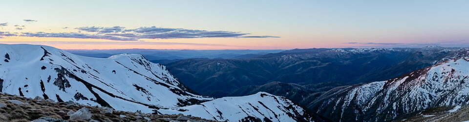
Sunrise from Cooyoyo lookout
Day 2: Sunday 3/04/2016 Cooyoyo campsite – The Castle return
Max elevation: 854 m
Total climbing: 455 m
Total descent: -454 m
Average speed: 2.33 km/h
Total time: 05:40:00
Today was the Castle summit day which would be a first for Mandy.
It was cool and overcast but spectacular as always.

Dave climbing the Castle

Sue climbing The Castle with Mandy waiting her turn

Mandy & Sue admiring the view over Byangee Mountain

Looking NW from the Castle
Steve and Sue decided to descend via the tunnel as we hadn’t done it for about thirty years. We said our goodbyes to Dave and Mandy who had been excellent company.
That night at camp we shared campfire stories with a group of two mothers with their daughters. They were having a lovely time except that one of the Mums took a 10 metre tumble while climbing Mt Owen. Luckily she was hardly injured.
Day 3: Monday 4/04/2016 Cooyoyo overhang

Cavewomen at Cooyoyo
Rain started overnight and increased in intensity during the morning. The fog was also rising and the bush was soaked. Our planned trip to Monolith valley was delayed and we spent the day in a camping cave. Luckily I had brought a good book. By early evening were were surprised to see stars, the sky had completely cleared.

Clear night at Cooyoyo after a cloudy day
Day 4: Tuesday 5/04/2016 Cooyoyo campsite – circumnavigation of Mount Cole
Max elevation: 894 m
Total climbing: 930 m
Total descent: -913 m
Average speed: 2.53 km/h
Total time: 10:05:41
The weather had cleared so we decided to head to Monolith Valley and beyond. We enjoyed taking lots of photos in the Green Room and around Seven Gods Pinnacles. From there we walked around the northern base of Mt Cole to Sunset Cave where we had lunch. Examining the map we began tossing up whether to try the negotiable route around to Trawalla Falls or walk back the way we came. Our adventurous spirit won this time but it was a decision we would regret later.

The Green Room in Monolith Valley

Tree roots in the Green Room

Sunset Cave under Mt Cole
The route to the falls was relatively easy walking but Trawalla Falls themselves were a mere trickle. We then decided we would head further around Mt Cole and go back over Mt Owen and cover some territory we hadn’t walked before.
We arrived at the base of Mt Owen quite quickly via the gully between Mt Cole and Mt Owen. We looked up at the steep scramble marked only by a rock cairn at its take-off point thinking it didn’t look that bad.
About half way up we started to regret our decision. As there were very few good handgrips and we felt we were balanced very precariously on the side of the mountain. However, by that stage it was safer to continue on rather than turn back. We had to block from our minds the thought that falling meant serious injury or death! We high fived at the top, our pulse rates were very high.

A steep hazardous climb up Mt Owen
However, our adventure was certainly not over for the day. We had to bush bash through and try to find the cairned negotiable route across the top of Mt Owen to lead us back to Monolith Valley. This was tricky in several places where the intermittent rock cairns were not quite close enough together, leading us temporarily along a couple of false leads.
Safely back into Monolith Valley the fun really began. We reached the small bridge across the creek with its adjacent sign to Mt Owen. Phew! Back on track. After about an hour of walking we found ourselves back at the same bridge. Intently looking for evidence of the track and rock cairns, together with the now overcast skies, we had lost situational awareness and had turned right around without realising it.
We then tried following the track, via GPS, only to find that impossible as the track marked on the NSW 1:25000 map (digital version) was just not there – we were now well and truely off track and “down” the creek. So we were off back to the bridge again! It was incredibly frustrating trying to work out what had occurred.
By this time it was 4:30pm and we had limited daylight left. We were considering whether we should camp out as we were both getting rather fatigued. One more try to get it right with regular checking of our GPS position on the map. Our problem point came about where the old track met the new track. From the creek end there is a “Revegetation Area” sign telling you to stay off that path, unfortunately the other end where we made our mistake did not have any such sign. At this point there is also a sharp steep rock ledge, with no visible indication it was part of the track. By this stage we were both too tied and cranky to place a new, clearly visible cairn in sight from the bottom, so hope not to many other people do as we did!
We were so happy to see the chains at Nibelung Pass on our descent and then to reach the saddle above Cooyoyo, bliss!!

NSW Topographic map with track marked in incorrect position
We arrived at camp just before dark after ten hours of walking. We were stuffed but so glad we didn’t have to camp out. What a day!
Day 5: Wednesday 6/04/2016 Cooyoyo campsite – Long Gully
Max elevation: 679 m
Total climbing: 155 m
Total descent: -179 m
Average speed: 2.28 km/h
Total time: 00:32:49
N.B. This track is incomplete owing to recording problems.

Sunrise from Cooyoyo lookout
We were a bit surprised we didn’t sleep in as we had been so tired. We watched a beautiful sunrise from the lookout, packed up and were walking before 9:00am. It was an uneventful walk out – a nice change from yesterday!
We enjoyed a refreshing swim at Long Gully campground and had a long anticipated visit back to the Heritage Bakery before driving home.
It was good to finish the walk intact. We decided that future walks should be a little less exciting. Overall it was an enjoyable trip.
Clickable icons on a world map which open the related trip report
A detailed, searchable trip list with links to reports, photo galleries and other content
![]()
Great notes and maps – thanks for this info – I have been to Monolith Valley twice – first time – 25 years ago – all route finding was easy and the climb up Mt Owen a doddle; second time – 15 years ago – everything was much harder and we lost our way in the swamp in after Nibbelung Pass; next time I will use your notes! Just did a walk down Brumby Ridge to the Kowmung – after a couple of moments of locational uncertainty I have decided to join the 21st century, ditch the map and compass, and buy a GPS!
Thanks Francesca, I appreciate your comments. I bought a Garmin etrex30 several years ago but then after purchasing a iPhone 6Plus I have been using it instead. I use the MemoryMap Topo app, which uses digital versions of the standard NSW topo maps. I have found using the phone to be vastly easier than using the etrex which I now leave at home. I also carry a USB device charging battery and solar panels on longer trips.
Hi , I am planning to walk from green gully camp site and stay overnight over there and next day with day pack like to go around “Cooyoyo campsite – circumnavigation of Mount Cole” , would like to know when you walk it was easy to walk of trace to track or not pls