
Friday 13/03/2026 Waikawa-Curio Bay Rd – Curio Bay – The Headland
Tumu Toka Curio Bay/Porpoise Bay area
Southland Region, NEW ZEALAND (Aotearoa)
Kāi Tahu Country (Ngāi Tahu people)
Participants: Beth Davies, Stephen Davies (Photos), Sue Davies (Report), Pablo Ureña Vega
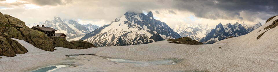
We drove along the Waikawa-Curio Bay Road on a cool, breezy March morning with a south-westerly pushing in — clouds stacked over the Catlins coast and the air in the low teens. From the roadside, a short, easy path rolls gently down towards the sea. It’s a wide, well-formed track of gravel, compacted earth and boardwalk with just a few steps and short slopes. Very easy going.
Max elevation: 30 m
Total climbing: 33 m
Total descent: -39 m
Average speed: 6.21 km/h
Total time: 01:10:01
As the tide eased back, the viewing platform revealed the famous fossil forest — a stone mosaic of ancient logs and stumps, petrified where they fell some 180 million years ago when this coast was part of Gondwana. The rock shelves gleamed dark and slick between the waves, which folded into the bay in long, slow sets with white spray blowing sideways in the wind. Fur seals dozed on the outer ledges, and seabirds wheeled overhead — Kelp Gulls (Larus dominicanus) patrolling the shoreline and New Zealand Fantails (Rhipidura fuliginosa) flitting along the headland.

New Zealand Fantail (Rhipidura fuliginosa) at Curio Bay
Looping along the clifftop, the route gives shifting views back over Porpoise Bay, out to the Southern Ocean, and down onto the fossil platforms below. A short, easy walk to one of the Catlins’ most remarkable sites. The fossil forest is truly extraordinary and well worth the visit.
Amongst other photographically recorded observations during this walk, we were able to confirm sightings of each of the following species: New Zealand Fantail (Rhipidura fuliginosa), Kelp Gull (Larus dominicanus)
Wild Adventures Facebook Group
Clickable icons on this world map will open the related trip report
A detailed, searchable trip list with links to reports, photo galleries
Information on Parks signage along the way
LIVING FOREST and WALKWAY
Are you ready to step back in time? his remnant forest stand is believed to be the only site in the world where a lush, green living forest lies so close to an exposed petrified forest.
This site’s importance meant that in 2009, the South Catlins Charitable Trust took on the task of securing the land, protecting it from predators and stock, rejuvenating the native bush and developing a walkway.
With the opening of the Curio Bay Living Forest and Walkway Project, everybody can enjoy a special slice of history.
You will hear the birdsong and see the young rimu stands just starting to grow, as well as the imposing and well-established kamahi-rata forest and a manuka wetland.
Enjoy the living representation of the forest that once stood here before making your way to its predecessor, the 170 million-year-old petrified forest.
Locals, visitors, businesses and community groups all had a hand in contributing to the protection of this area, making this a truly community-owned project. Their support has made the development of this walkway possible. The Trust is grateful for their assistance.
Visit us again – as the forest slowly rejuvenates, it will give its guests a unique and different experience each time. Donations are gratefully accepted.
The local landscape features, geology, scenic highlights, flora, fauna, Indigenous history, white history and other nearby walks in the area (Perplexity AI Model)
Landscape features
Curio Bay sits on a low, rugged coastline where gently sloping headlands meet narrow rock platforms and a broad, crescent-shaped bay. Low cliffs and terraces step down towards the sea, creating a sequence of ledges that are alternately exposed and washed by the tide. At low tide the shore opens to reveal a striking stone pavement of fossilised tree trunks and stumps, arranged across the intertidal zone like a submerged forest. Inland from the brink, the ground rises only modestly, forming a shallow, wind-swept rise carrying grass, shrubs and patches of coastal scrub. The overall impression is of an open, elemental landscape where sea, wind and rock dominate, and the scale feels intimate rather than mountainous.
Geology
The geology of Curio Bay is internationally significant because it preserves an extensive Jurassic fossil forest within coastal sedimentary rocks. Around 180 million years ago this area formed part of a forested coastal floodplain on the eastern margin of the supercontinent Gondwana, with successive forests growing on low-lying ground prone to flooding. Repeated sheet floods of volcanic debris overwhelmed the living forest several times over roughly 20,000 years, burying trunks and stumps in fine sediments that later hardened into sandstone and mudstone. Over millions of years silica-rich fluids permeated the buried wood, gradually replacing organic material and turning it to stone while preserving growth rings, bark textures and branching forms. More recently, coastal erosion has cut back the cliffs and stripped away overlying layers, exposing bands of petrified logs on both the intertidal rock platform and the adjacent cliff faces.
Scenic highlights
Key scenic highlights include the sweeping view over Curio Bay and Porpoise Bay, framed by low headlands and backed by rolling farmland and coastal scrub. The petrified forest itself is a focal point, best appreciated from the viewing platform where the pattern of stumps and logs becomes clear against the wet rock. At different stages of the tide, waves surge over the fossil pavement, alternately concealing and revealing the stone tree trunks in a rhythm that emphasises the meeting of geological time and present-day weather. The coastline also offers dramatic seascapes, with long lines of swell, occasional plumes of spray against the rock ledges and shifting bands of light across the water. In calm conditions, the sandy curve of Porpoise Bay contrasts with the darker, rougher rock shelves of Curio Bay, creating a varied and visually rich coastal scene within a compact area.
Local flora
Vegetation near the track and headland consists mainly of coastal grassland, low shrubs and patches of regenerating forest typical of the Catlins. Inland and along more sheltered sections, forest remnants include a mix of broadleaf species and tree ferns, forming a layered canopy that differs markedly from the open, wind-scoured edges. The Living Forest walkway at Curio Bay is designed to suggest how the Jurassic forest might have appeared, using present-day plant communities to evoke dense, moist woodland with ferns and conifers. Salt spray and persistent wind shape the outer margin of vegetation, keeping plants low and sculpted, with grasses and hardy shrubs dominating near the cliffs and along exposed ridges. Seasonal changes bring subtle variations in colour and texture, from the fresh greens of new growth to the weathered tones of tussocks and coastal scrub under winter skies.
Local fauna
Curio Bay is renowned for coastal wildlife that frequents the shores and nearshore waters around the headland. Hector’s dolphins, one of the smallest marine dolphins, often appear in the surf of nearby Porpoise Bay, especially in warmer months when the sea is calmer. Yellow-eyed penguins come ashore to nest in the area, moving between sea and land in the evenings and making use of coastal vegetation for cover. New Zealand fur seals and sea lions regularly haul out on rock platforms, using the flat ledges to rest between foraging trips. Overhead, a range of seabirds including shags, shearwaters and other coastal species patrol the coastline, taking advantage of updrafts along the cliffs and the rich feeding grounds of the Southern Ocean.
Indigenous history
The wider Catlins coast, including Curio Bay, lies within the ancestral lands of Kāi Tahu (Ngāi Tahu), whose traditions and whakapapa connect deeply with this shoreline and its resources. For Māori, the coast provided an abundance of food, including fish, shellfish, seabirds and forest products, supporting a pattern of seasonal movement that linked sheltered harbours with forested interior valleys. Waikawa Harbour, north of Curio Bay, was an important seasonal campsite, and midden sites along the coast record repeated visits over generations. Place names across the Catlins encode histories, events and relationships, serving as mnemonic anchors for stories that tie people to specific headlands, bays and rivers. The contemporary name Tumu Toka, used for the Curio Bay experience centre, acknowledges mana whenua and evokes the significance of the petrified forest as both taonga and teacher.
White history
European exploration and settlement in the Catlins intensified in the nineteenth century, driven by interests in timber, farming and coastal trade. As pastoral farming expanded, much of the coastal forest was cleared, leaving fragments that hint at former continuous cover along headlands and valleys. Curio Bay’s fossil forest attracted scientific attention early; concerns about fossil collecting led to legal protection in 1928 and, later, designation as a scientific reserve in the early 1980s. The broader region has since been promoted through initiatives such as the Southern Scenic Route and the Catlins Coastal Heritage Trail, encouraging visitors to experience both natural and cultural heritage. More recently, the establishment of the Tumu Toka Curioscape visitor centre has created a focal point for interpretation, balancing tourism with conservation and formalising infrastructure such as viewing platforms, tracks and facilities around the bay.
Clickable icons on this world map will open the related trip report
A detailed, searchable trip list with links to reports, photo galleries
![]()