
Saturday 28/10/2023 Mount Zero Picnic Area – Mt Zero Walk – Mount Zero
Grampians National Park, VICTORIA
Gariwerd Country
Participants: Stephen Davies (Photos, Report), Sue Davies
This was our second attempt at this walk, on the 20th we had driven to the start after lunch but decided against it as it was already 32C, calm and cloudless, a little too hot for our liking. At least for this 3:00pm departure, it was only 25C and breezy.
Max elevation: 365 m
Total climbing: 301 m
Total descent: -297 m
Average speed: 3.69 km/h
Total time: 02:23:05
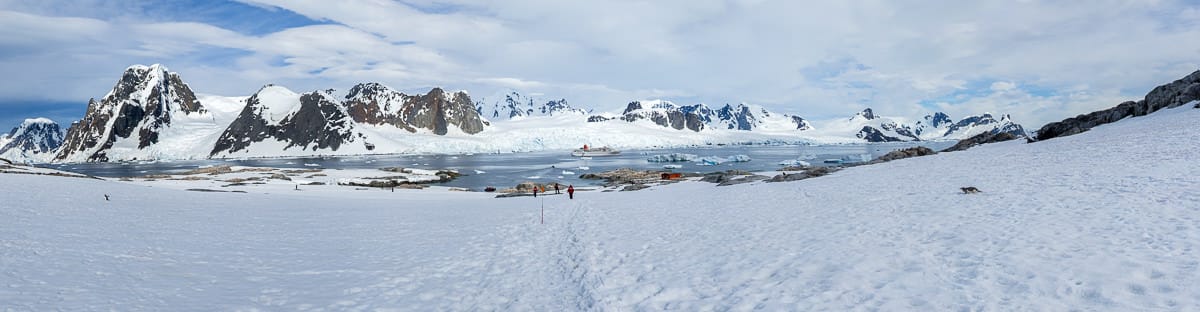
Starting from the Mount Zero Picnic Area we headed off across the road to get onto the track which is initially about two metres wide with a consolidated earth base and a light sand covering. As the track starts to climb, there are a series of wooden risers forming steps. However, before too long the track narrows and there are an increasing number of rocks and boulders, eventually replacing any semblance of a path. As you get into the climbing some boulders have been placed as steps and there is a worn surface along bedrock to follow between mostly painted on yellow triangular track markers.
There were plenty of melaleucas still in full bloom, each welcoming a large number of busy insects, predominantly bees. The views kept broadening as we got higher, with more and more of the Grampians to the south coming into view. Once on the summit, expansive views over the surrounding plains were in clear sight with The Arapiles standing out to the west.
On the return leg, Sue decided to continue at her own pace to allow me to amuse myself with my camera. The first challenge I set was to get one of the black and white butterflies that were flittering around the trees at the summit in flight and in focus, after a lot of effort I eventually got one shot. Further down at a spectacularly flowering melaleuca, I aimed to get some skittish insects feeding on the nectar, again with some success.
A little further on I noted an odd three-way track marker, so decided to try the way we didn’t follow on the climb up. I was very glad that I did, as it leads to and goes through a very impressive “slot canyon”. This is a little narrower than shoulder width at one point and provides another photographic challenge with an extreme difference light light levels within the canyon and outside. Accepting the challenge I was able to get some decent photos here as well.

Mount Zero slot canyon
Once catching up with Sue at the Mount Zero Picnic Area, she pointed out a couple of nesting birds feeding their young. The last challenge of the afternoon was now to try to catch them in the act of feeding. Catching the magpies proved elusive as the handover was extremely fast and the only position I could stand in was almost directly into the sun, making it extraordinarily difficult to see the adult return. Two trees over we watched a Kookaburra make a couple of deliveries to its young who were hidden away in a tree hollow. (The next day I returned, only to discover that the Kooabuura was actually chasing insects, bees I think, that had a nest in the tree hollow)
Information on Parks Victoria signage along the way
The Northern Grampians area offers breathtaking natural beauty on a grand scale. Massive sandstone outcrops and eucalypt covered slopes tower above the surrounding Wimmera plains. This remarkable landscape is rich in Aboriginal culture and European Heritage and provides a number of bushwalking opportunities to explore rugged and remote peaks.
Walks from Hollow Mountain Car Park
HOLLOW MOUNTAIN (MOUNT WUDJUB-GUYAN)
Distance: 2,2 km return Time: 1 – 11 hours 1.
Grade: 4. Short steep hills, formed track some obstacles, many steps
Start: Hollow Mountain car park trailhead
This walk suitable for fit and energetic walkers, can involve water crossings, slippery rock hopping and rock scrambling. Supervise children closely.
From the carpark, follow the defined track as it climbs to the base of an iron stained cliff. A short rock scramble then leads you up and over rocky boulders and rock ledges to a sparsely vegetated outcrop. A short scramble then leads to the summit and amazing views. Return via the same route.
GULGURN MANJA (ABORIGINAL ART SITE)
Distance: 1km return Time: 20-40minutes.
An Grade: 2 Gentle hills, formed track, occasional steps
Start: Hollow Mountain car park trailhead
The Jardwadjali Aboriginal people welcome you to this area and ask that you take a minute to reflect on the culture and heritage of this site and the mountain range traditionally known as Gariwerd.
From the carpark, a short stroll through banksia forest gently winds its way to the shelter where art depicts “the hands of you people. Return via the same route.
A RECOVERING LANDSCAPE
In January 2014 a large bushfire swept through the Northern Grampians, This area is now a fragile recovering landscape, Please stay on designated tracks and be mindful of revegetation. Some temporary closures may be in place.
Camping: Camping is available at Plantation Campground, located on Mt Zero Road, approximately 10km north of Halls Gap. The site has pit toilets, some picnic tables and fireplaces. Dispersed bush camping is not permitted within the fire affected area.
Check latest Park updates at www.parks.vic.gov.au
ROCK CLIMBING
The Northern Grampians rocky sandstone peaks offers some of Australia’s finest rock climbing experiences. From the Hollow Mountain car park, enjoy easy access into popular crags such as Summerday Valley, Hollow Mountain and Mt Stapylton Amphitheatre.
When climbing, please remember that the Northern Grampians is a fire affected area. Any impacts on fragile soils, vegetation and cultural heritage will stay in the landscape for the long term
. • Climb Sustainably – visit open crags only and avoid any off track walking
• Follow climbers safety codes and etiquette
• Avoid large groups at small crags
• Try out some of the Grampians other popular climbing areas
• Guide books may not have the latest information
• Check for rock climbing updates by visiting the Parks Victoria webpage www.parks.vic.gov.au or by phoning 13,1963.
You can also obtain information by visiting Brambuk the National Park and Cultural Centre in Halls Gap, open 9am – 5pm daily. Phone 5361 4000.
Walks from Mt Zero Car Park
Relax in the beauty of the Grampians by visiting this beautiful picnic ground. There are toilets, fireplaces and picnic tables. The walks to Flat Rock,-Mt Stapylton and Mt Zero start here.
MT STAPYLTON Return only)
Distance: 4.6 km return (to Mt Zero Pichic Area) Time: 2 – 2½ hours f.
Grade: 4 Short steep hills, formed track some obstacles, many steps.
Start: Mt Zero picnic area trail head
This walk is suitable for fit and energetic walkers and can involve slippery track surfaces, rock hopping and rock scrambling. Signs and track markers guide the way up the steep rock slope of Flat Rock to a splendid vantage point overlooking a natural amphitheatre. The track descends to the base of Taipan Wall before continuing along rock terraces to an intersection, Follow signs and track markers to the final steep ascent. The view from the summit is spectacular, taking in much of the park and surrounding plains. Return by the same route.
FLAT ROCK
Distance: 1.0km return Time: 45mins -1 hour
Grade: 3 Short steep hills, formed track some obstacles, many steps,
Start: Mt Zero picnic area trail head
This short walk is the first section of the Mt Stapylton walking track and involves some strenuous uphill walking. From the Mt Zero Car park trailhead, follow track markers as they wind their way up a large slab of rock. At the top, enjoy views over the Stapylton Amphitheatre and the impressive orange cliff known as Taipan Wall. After rain, enjoy exploring numerous rock pools and green moss beds.
MT ZERO
Distance: 2.8 km return Time: 1 – 1½ hours
Grade: 4 Short steep hills, formed track some obstacles, many steps
Start: Mt Zero picnic area trail head
From the picnic area, carefully cross the Halls Gap-Mt Zero Road and track markers will guide you up the rocky hillside. Near the top of the ridge the track becomes steeper with rock steps that lead up to the summit. Enjoy views of Mt. Stapylton and the surrounding Wimmera plains. Return by the same route.
AUSTRALIAN WALKING TRAIL GRADING SYSTEM
The Australian Walking track grading system assists you to understand the features and difficulty rating of a walking track. Choose a walk that suits your timeframe, bushwalking experience and fitness ability.
Grade 1: No bushwalking experience required. Flat even surface with no steps or steep sections. Suitable for wheelchair users who have someone to assist them.
Grade 2: No bushwalking experience required. The track is a hardened or compacted surface and may have a gentle hill section or sections with occasional steps.
Grade 3: Suitable for most ages and fitness levels. Some bushwalking experience is recommended. Tracks may have short steep sections, a rough surface and many steps.
Grade 4: Bushwalking experience recommended. Tracks may be long, rough and very steep. Directional signage may be limited Grade 5: Very experienced bushwalkers with specialised skills, including navigation and emergency first aid Tracks are likely to be very rough, very steep and unmarked.
From Grampians National Park Visitor Guide
Environment, culture and heritage
Aboriginal cultural heritage
The park, traditionally known as Gariwerd, has an Aboriginal cultural history dating back at least 22,000 years. The landscape holds this heritage and protects many important cultural sites, including the largest collection of rock art in south-eastern Australia.
Begin your cultural journey at Brambuk, or visit one of five easy to access rock art shelters open to the public; Ngamadjidj, Gulgurn Manja, Billimina, Manja and Bunjils (Black Range Scenic Reserve near Stawell).
Post settlement history
The Grampians was named after the Grampian Mountains in Scotland by Major Thomas Mitchell on his 1836 expedition. Since this time the area has seen much change through resource industries such as forestry, stone quarrying, gold mining and water harvesting. People have been drawn here for thousands of years and tourism established its roots in the early 1900s. More than 1.3 million people from all over the world visit the park annually.
Geology
The four distinct sandstone ranges of the Grampians began forming approximately 430 million years ago. Over time, geological processes such as pressure, heat, folding, faulting and erosion have slowly shaped the mountains we see today. Geology is fundamental to soil composition and influences where flora found here.
Plants
The park protects one third of Victoria’s flora species and is the most important botanical reserve in the state. Close to 970 native species occur and over 40 are found nowhere else in the world. The area is known for its colourful spring wildflower displays and popular walks include Heatherlie area, Sundial Peak, The Piccaninny and Mt Zero.
Wildlife
The park provides habitat for at least 230 bird, 40 mammal, 30 reptile, 11 amphibian and 6 native fish species. There are 50 known species in the park classified as threatened, including Brush-tailed Rock Wallabies, Smokey Mice and Powerful Owls. Halls Gap and Fyans Valley are one area to see Eastern-grey Kangaroos, Emus and to hear kookaburras. Usually at dawn and dusk.
Clickable icons on this world map will open the related trip report
A detailed, searchable trip list with links to reports, photo galleries and other content
![]()