
Friday 20/10/2023 Hollow Mountain Carpark – Hollow Mountain Walking Track – “Hollow Mountain Cave” – Wudjub-Guyan (Hollow Mountain) (409m) – Wall of Fools
Grampians National Park, VICTORIA
Gariwerd Country
Participants: Stephen Davies (Photos, Report), Sue Davies
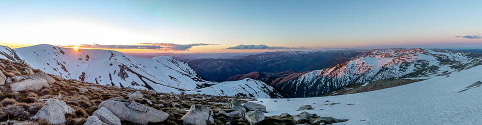
The fine sunny, calm day was beginning to heat up as we got underway at 10:20am. Initially, the track is along a broad, sandy, yellow path, with wooden-faced steps appearing as a gentle ascent begins. This passes through flowering heathland where we noticed a considerable variety of species including Banksia Serrata (Old Man Banksia), Eucalyptus, Melaleuca, Grevillea and Xanthorrhoea. The track then transitions into an increasingly uneven and steepening tree-lined route as it approaches the cliff line. Behind us, as we climbed, we noted more eroded sandstone cliff faces topped with a very jagged skyline.
Max elevation: 382 m
Total climbing: 313 m
Total descent: -299 m
Average speed: 3.89 km/h
Total time: 02:16:04
The sandstone cliffs in this area are very colourful, ranging from bright reddish tones through to yellows, greys and white often appearing as stripes. Once to the cliff line, we turned left, hopping over a series of very large boulders before deciding we were off-track and retracing our steps back to where we had turned. Here on the steep rock face that was a sharp right-hand turn we had missed when approaching along the track, we could make out a very faded, yellow track marking triangle halfway up. This is positioned almost behind your back as you approach the turn, so I expect a lot of people would turn left as we did.

Views on route to Hollow Mountain
From here there is a lot of scrambling required and in a couple of places might prove challenging to people who are not confident in their climbing skills, or get anxious with heights. After a couple of hundred metres, it opens up and returns to walking, this time across the sandstone bedrock of the mountain. Here the footing is uneven but it is way easier than the scrambling below.
Approaching Hollow Mountain summit we were quite dismayed we had not yet passed the cave featured in the Parks Victoria, Northern Day Walks, Grampians National Park brochure. That photo shows four people near the cave entrance which appears at least twice their height, with views of open plains below. Here instead we could only find a young couple sitting in the shade of a tiny overhang just below the summit. They had spent some time scouting around trying to find that same mystical brochure cave.
The views from the summit are fantastic, with colourful sandstone cliffs having been weathered into a myriad of interesting forms. On the way down from the summit we kept our eyes out to see if we had missed the expected big cave, without success. What we did find was a cave formed under a large collapsed slab that was large enough to sit in. This provides a great window to the outside world photo opportunity, although a little less grand than advertised.
Continuing our return down the slab, I hugged the base of the cliff line instead of following the route, as I had noted a gap that appeared worth checking out. Reaching the narrow point you can step over to a wide ledge, if you don’t mind a bit of a drop as you do. The views from along the ledge are very dramatic as you are surrounded by colourful sandstone cliffs with lots of green forest below.
Returning to the track down the scree slope had us on all fours several times, always better than a slip on two feet. By now it had become very hot and we were keen to find some more shade, however, a side track to the right on the way back caught my attention and I couldn’t resist. This minor track leads off to the “Wall of Fools”, a rock-climbing area. Along the wall, there have been seat-height stone walls and a walking path established, making it a great spot to hang out for a while.
Back at the car park, we found a shady spot on a park bench for lunch, before later visiting the Gulgurn Manja Shelter Walk which starts from the same carpark.
From Grampians National Park Signs
Hollow Mountain (Wudjub-Guyan)
Not for the faint hearted
Grade 4: (Hard) Challenging steep sections, exposed rocky outcrops and cliffs.
Return: 2.2km, 1-1.5 hours Start from Hollow Mountain Carpark:
Harder walks like this are best done with a quality walking map of the area. Follow the signs and yellow arrows that eventually climb up rocky steps, passing over rocky slabs to finally reach a wind-scoured cavern and on up to the summit (elevation 388m).
Welcome to the Grampians Peaks Trail
The Grampians National Park is part of the Greater Gariwerd cultural landscape, in the traditional Country of the Jadawadjali and Djab Wurrung People. Represented by Barengi Gadjin Land Council, Eastern Maar Aboriginal Corporation and Gunditj Mirring Traditional Owners Aboriginal Corporation, Traditional Owners have a deep and continuing connection to the lands and waters of this landscape, and Parks Victoria recognises their ongoing role in caring for Country.
Step onto a new adventure
The spectacular 160km Grampians Peaks Trail is a once-in-a-lifetime hiking experience that can be done as the full 13 day/12 night hike, traversing north to south, or in shorter sections with many different trail options for hikers to enjoy.
Mt Zero Trailhead
Mt Zero (Mura Mura)
The most northern mountain
Grade 3: (Medium) Return walk: 2.2km, 1 – 1.5 hours
Start from the picnic area carpark
Walk north across the road passing through low heathland before ascending into rocky terrain. A steep final climb brings you to the summit’s stone cairn (elevation 390m).
Flat Rock viewpoint Nature’s sculptured garden
Grade 3: (Medium)
Return: 1km, 15 – 30 minutes
Start from behind Mt Zero Picnic Area:
Follow yellow markers up the slanting rock slope known as Flat Rock – with its bonsai moss gardens, rivulets and rockpools.
Gulgurn Manja Shelter ‘Hands of the young people’
Grade 2: (Easy) Return: 1.5km, 30 minutes
Start from Hollow Mountain Carpark:
This short, easy walk leads to an Aboriginal rock shelter art site with on-site information reminding us that Gariwerd is alive with the spirit of its ancestors.
Hollow Mountain (Wudjub-Guyan)
Not for the faint hearted
Grade 4: (Hard) Challenging steep sections, exposed rocky outcrops and cliffs.
Return: 2.2km, 1-1.5 hours Start from Hollow Mountain Carpark:
Harder walks like this are best done with a quality walking map of the area. Follow the signs and yellow arrows that eventually climb up rocky steps, passing over rocky slabs to finally reach a wind-scoured cavern and on up to the summit (elevation 388m).
Mt Stapylton (Gunigalg) Loop Also links to Stapylton Campground
Grade 4: (Hard) Loop: 10.2km, 5 – 5.5 hours
Start from behind Mt Zero Picnic Area:
Follow trail markers up Flat Rock. Keep an eye out for ‘bird rock’ as you pass through the Stapylton Amphitheatre before reaching the Mt Stapylton summit intersection (600m return walk from this junction). Signposts guide you back towards Stapylton Campground and the Stapylton Amphitheatre/Flat Rock and on down to Mt Zero Picnic Area.
Ngamadjidj Shelter Near Stapylton Campground
Grade 2: (Easy) Loop: 900m, 20 minutes
Start from Ngamadjidj Shelter Carpark:
This short, easy walk leads to an Aboriginal rock shelter art site with on-site information reminding us that Gariwerd is alive with the spirit of its ancestors.
——
Explore ways of seeing Gariwerd on the Grampians Peaks Trail
A sculpted land
In the Dreaming, the Great Ancestor Spirit, Bunjil, began to create this place – Gariwerd. ‘He often took the form of Werpil the Eagle to view his work’. *GW.
Mountains made of the Gods ‘The geological record and Aboriginal Dreaming share one thing in common – transformation and rebirth. The creation story involves… superhuman sacrifice, while the geological story involves the engine of tectonic plate movement.”-*GW
‘Gariwerd is far more than a mere descriptor, it means literally, mountain range made of our gods’. *GW Bunjil needed help to finish creating the world. He asked the two Bram-bram-bult brothers, sons of Druk the Frog, to bring order. The brothers named all the creatures, made the languages and gave the laws to the new world. g’Antink
Place names Place names reflect stories from the Jadawadjali and Djab Wurrung Dreaming. The mountains of Gariwerd were central to the dreaming of the two Bram-bram-bult brothers whose legendary exploits are credited with creating many of its features.
As they created the world, the ancestors left signs of their passing across the land. Some of Gariwerd’s names relate to their actions and interactions.
The name Gariwerd is formed from two Jadawadjali and Djab Wurrung words for body parts: Gar, meaning nose, and werd, meaning shoulder.
Together, they signify how the mountain range is made up of the body parts of the ancestors.
Gar (Mt Difficult) not only looks like a nose; it was once some ancestral being’s nose.
Mud-Dadjug (Mt Abrupt) does not simply resemble a blunt arm; it was, in fact, a creator’s cast-aside arm.*GW.
A spirit of connection
In the Dreaming, at the beginning of creation, a group of Ancestor heroes, some superhuman, some with animal characteristics, emerged and embarked on epic journeys across the then featureless and barren countryside of the Australian continent and created the world as it is.
As part of the telling, the ancestral track was told in stories, painted, sung and danced.
The Traditional Owners name for Hollow Mountain is Wudjub guyn (pronounced Wutjup guyun), which means ‘spear in the middle.’ The ancestors transformed at the end of their journeys to become features of the landscape.
Their dreaming tracks sculpted the mountains and rivers. They made the plants and animals. And as they journeyed, each ancestor being brought forth the different Aboriginal peoples, fixing the rules ” and rituals of their culture and life.
Knowing the story behind a waterhole’s formation or when emus lay their eggs gave the Jadawadjali and Djab Wurrung people not only a spiritual connection to their land, but also a map of survival.
Gariwerd rises clear of the sea
“Nature is ever at work building and pulling down, creating and destroying, keeping everything whirling and flowing, allowing no rest but in rhythmical motion, chasing everything in endless song out of one beautiful form into another.” – John Muir
Dreaming story of Tchingal
Gariwerd’s rocky outcrops, gullies, and streams are more than features of the land – they are links to the Dreaming and the ancestors, to be respected and treated with love.
In the beginning, the ancestor beings journeyed here, shaping the landscape.
Tchingal was a gigantic and ferocious emu. He was the protector of one precious egg
One day, while Tchingal was away from the nest, Waa the crow flew by. The crow was hungry, so he picked at the egg. When Tchingal saw this, he was furious. He chased Waa the crow all the way to Gariwerd.
Waa flew into a crack in the mountains, but Tchingal ran and struck it with his foot. The rock split in two, creating Barigar (Roses Gap), meaning ‘mountain stream’. The crow flew on, but the emu was close behind. Again, Waa hid in the mountains, but Tchingal kicked them right open. This created Jananginj Njaui (Victoria Gap), allowing Bugara (Glenelg River) to flow out on to the western plains.
A blank sheet of sea and sky
In simplified terms, an ancient mountain range towered above a deep surrounding sea.
Over a vast sweep of time, the ancient highland peaks were worn down by eons of erosion. They were stripped down, disappearing to become the floor of a shallow ocean.
The sediments cemented together and after hundreds of millions of more years were thrust skyward to create a new place – Gariwerd.
It took a violent tectonic event to wake Gariwerd from its slumber. Western science suggests that 500 million years ago, the landscape you see here was covered by a deep ocean.
So, the mountain range you hike today, began in a basin at the bottom of a shallow sea (verified by fossil records), filled with mud, minerals and rock forms eroded from the older exposed highlands.
Saved by a hard cap
In geological terms the distinctive topography of this region is a result of folding and faulting, and subsequent erosion of quartz capped, sandstone ranges.
If it were not for that cap of resilient quartz, these mountains may also have become rubble eons ago. As it is, the softer red siltstones and sandstones have eroded to form the valleys between the ranges.
The garden of Victoria
When botanist Ferdinand von Mueller set out to explore the western and northern regions of Victoria in late 1854, he was so impressed by the Grampians variety and diversity of flora that he referred to the ranges as “the garden of Victoria.”
Carpets of colour
Gariwerd is home to one-third of all Victorian plant species. Mountains, wooded slopes, heathy valleys and sandy swamp floors providing myriad niches for a wide variety of plants to thrive.
Colour your world
In any month of the year there is a plant waiting for you to discover its silent beauty through petal, leaf or bark. Look to nature’s colour palette for the: reds of flame grevillea, running postman; golds of guinea flower and wattle; blues of tinsel lily, daisies and love creeper; mauves, pinks, purples of orchids heath and pink bells; delicate pinks and whites of snow myrtles and the snow whites of the unique Grampians Thryptomene.
Wonders of nature From as early as the 1860s the scenic beauty of the area, particular around Halls Gap, was a great attraction for artists, naturalists and newspaper correspondents.
The Grampians also became a magnet to other adventurers wanting to experience the wonders of nature’.
‘In the early 1890s, the Chautauquan Movement was formed in the USA in 1874. The movement’s teaching was a mixture of intellectual and spiritual studies along with the promotion of a healthy living and appreciation of the natural world. Several large gatherings occurred in Halls Gap around 1893-4 and local residents of Halls Gap were inspired to name the rocky outcrop overlooking the picnic site as Chautauqua Peak.’
Extract from Victoria’s Wonderland, A Grampians history: Halls Gap & Grampians Historical Society Inc.
Alive with variety
Close to 1,000 different flowering plants occur in the Grampians National Park, almost one-third of Victoria’s entire indigenous flora.
The tricky little sundew, with its sticky little hairs, catching unsuspecting insects with its tiny, sticky snares!
During winter, spring and early summer look for sundews low on the ground. About as wide as a 50 cent coin, the tiny, scented sundew packs a bite in order to gain extra food not found in the soil! Don’t be fooled by its beauty – this hungry plant lures insects onto its sticky red or green leaves, trapping them for dinner.
The world’s first bread was baked here, using flour ground from murnong (yam daisy). The plant’s edible tubers grow underground, like potatoes. Gariwerd was once rich in murnong, grown and harvested by Traditional Owners, who used its starch rich tuber as an important food source.
Fire triggers new life
You might recognise the bristly, flowering cones17. of the rock banksia. While in bloom, birds such as honeyeaters will sip nectar from the flowers. Fire kills the adult banksia plants, although the hard woody cone has adapted to live with fire. It protects the seed, opening after fire, allowing the seedlings to rise from the ashes.
Ancient and unique to Australia, Grass-trees have adapted to flourish following wildfire when they send tall flower-spikes skyward; attracting eager flower pollinators and providing vital food for recovering wildlife.
A mountain wildlife refuge
Many special animals call central Gariwerd home; birds, mammals, insects and crustaceans – some so rare this is their last foothold on earth, their final refuge for survival in a rapidly changing world
Peregrine Falcon
What did I see that morning?
That crossbow silhouette, that sabring fall from the sky… quick striking curve… unmistakably a peregrine.
Hot winter sun on the face’s brink, felt as red but seen as gold.
Air, still, blue.
Tremors at the edge of vision: 19. quick dark curve and slow straight line over green, gold in the eye.
Intersection, shrapnel of down, grey drop to crop, flail and clatter, four chops and the black star away with quick wing flicks.
– JA Baker (The Peregrine)
Mountain Galaxia
As you pass flowing streams and sandy pools, watch for a glimmer of the tiny native Mountain Galaxia fish. Smaller than your palm, they are often seen feeding on insects amongst rocks or waterside plants.
Other fantastic beasts found include glowing scorpions, land snails hungry for flesh, and pinching swamp crayfish.
Rocky daredevils bounce back
Among the wild jumble of rocky knolls and cliffs springs a shy, marsupial acrobat.
Their padded, flexible feet and brushy tipped tail help them bounce and balance as they ricochet across rocky ledges and uneven ground.
Once hunted for their meat and fur, Brushtailed Rock-wallabies are now critically endangered in Victoria due to overhunting and predation from foxes.
A successful breeding 20 relocation program has returned these rocky daredevils back among the lofty crags and crevices of Gariwerd.
Singing from the same page
“This continent’s original inhabitants cast themselves as part of the seamless web of all things that make up the greater song.
“To them their country was an unfolding narrative. As they moved along their ancestral Dreamtime tracks, retelling their creation stories, they brought their country alive through recitation of song cycles, dancing and corroborees, leaving their marks on rocks and sand; their voices echoing across Gariwerd – alive with the spirit of its ancestors.
Life was good
“On the plains large numbers of lakes and swamps offered a wide range of reliable food resources, both plant and animal.
“Gariwerd’s ranges held rock shelters close to streams, stone quarries for tool-making, ample timber for cooking and warmth, and extensive forests harbouring valuable food and material sources such as possums.
“The newcomers believed that they had struck prime real estate. Early settlers described the plains of western Victoria as looking ” just like a gentleman’s park.” Explorer Major Mitchell gave it the Latin appellation of Australia Felix – Australia the Blessed.” *GW
With the coming of Europeans, Gariwerd’s bountiful landscape was under siege from a wave of newcomers to the land, on a scale not previously known, triggering the devastation of eons of cultural and ecological diversity.
The future
The challenge ahead is to learn from the past and work together toward a future that acknowledges the contemporary relationship between culture, landscape and management.
“It might be time to redirect our dreams… we are here and not somewhere else.”, eminent scientist George Seddon. *GW
*GW: The People of Gariwerd, THE GRAMPIANS’ ABORIGINAL HERITAGE, Gib Wettenhall.
The Northern Grampians area offers breathtaking natural beauty on a grand scale. Massive sandstone outcrops and eucalypt covered slopes tower above the surrounding Wimmera plains. This remarkable landscape is rich in Aboriginal culture and European Heritage and provides a number of bushwalking opportunities to explore rugged and remote peaks.
Walks from Hollow Mountain Car Park
HOLLOW MOUNTAIN (MOUNT WUDJUB-GUYAN)
Distance: 2,2 km return Time: 1 – 11 hours 1.
Grade: 4. Short steep hills, formed track some obstacles, many steps
Start: Hollow Mountain car park trailhead
This walk suitable for fit and energetic walkers, can involve water crossings, slippery rock hopping and rock scrambling. Supervise children closely.
From the carpark, follow the cary defined track as it climbs to the base of an iron stained cliff. A short rock scramble then leads you up and over rocky boulders and rock ledges to a sparsely vegetated outcrop. A short scramble then leads to the summit and amazing views. Return via the same route.
GULGURN MANJA (ABORIGINAL ART SITE)
Distance: 1km return Time: 20-40minutes.
An Grade: 2 Gentle hills, formed track, occasional steps
Start: Hollow Mountain car park trailhead
The Jardwadjali Aboriginal people welcome you to this area and ask that you take a minute to reflect on the culture and heritage of this site and the mountain range traditionally known as Gariwerd.
From the carpark, a short stroil through banksia forest gently winds its way to the shelter where art depicts “the hands of you people. Return via the same route.
A RECOVERING LANDSCAPE
In January 2014 a large bushfire swept through the Northern Grampians, This area is now a fragile recovering landscape, Please stay on designated tracks and be mindful of revegetation. Some temporary closures may be in place.
Camping: Camping is available at Plantation Campground, located on Mt Zero Road, approximately 10km north of Halls Gap. The site has pit toilets, some picnic tables and fireplaces. Dispersed bush camping is not permitted within the fire affected area.
Check latest Park updates at www.parks.vic.gov.au
ROCK CLIMBING
The Northern Grampians rocky sandstone peaks offers some of Australia’s finest rock climbing experiences. From the Hollow Mountain car park, enjoy easy access into popular crags such as Summerday Valley, Hollow Mountain and Mt Stapylton Amphitheatre.
When climbing, please remember that the Northern Grampians is a fire affected area. Any impacts on fragile soils, vegetation and cultural heritage will stay in the landscape for the long term
. • Climb Sustainably – visit open crags only and avoid any off track walking
• Follow climbers safety codes and etiquette
• Avoid large groups at small crags
• Try out some of the Grampians other popular climbing areas
• Guide books may not have the latest information
• Check for rock climbing updates by visiting the Parks Victoria webpage www.parks.vic.gov.au or by phoning 13,1963.
You can also obtain information by visiting Brambuk the National Park and Cultural Centre in Halls Gap, open 9am – 5pm daily. Phone 5361 4000.
Walks from Mt Zero Car Park
Relax in the beauty of the Grampians by visiting this beautiful picnic ground. There are toilets, fireplaces and picnic tables. The walks to Flat Rock,-Mt Stapylton and Mt Zero start here.
MT STAPYLTON Return only)
Distance: 4.6 km return (to Mt Zero Pichic Area) Time: 2 – 2½ hours f.
Grade: 4 Short steep hills, formed track some obstacles, many steps.
Start: Mt Zero picnic area trail head
This walk is suitable for fit and energetic walkers and can involve slippery track surfaces, rock hopping and rock scrambling. Signs and track markers guide the way up the steep rock slope of Flat Rock to a splendid vantage point overlooking a natural amphitheatre. The track descends to the base of Taipan Wall before continuing along rock terraces to an intersection, Follow signs and track markers to the final steep ascent. The view from the summit is spectacular, taking in much of the park and surrounding plains. Return by the same route.
FLAT ROCK
Distance: 1.0km return Time: 45mins -1 hour
Grade: 3 Short steep hills, formed track some obstacles, many steps,
Start: Mt Zero picnic area trail head
This short walk is the first section of the Mt Stapylton walking track and involves some strenuous uphill walking. From the Mt Zero Car park trailhead, follow track markers as they wind their way up a large slab of rock. At the top, enjoy views over the Stapylton Amphitheatre and the impressive orange cliff known as Taipan wall. After rain, enjoy exploring numerous rock pools and green moss beds.
MT ZERO
Distance: 2.8 km return Time: 1 – 1½ hours
Grade: 4 Short steep hills, formed track some obstacles, many steps
Start: Mt Zero picnic area trail head
From the picnic area, carefully cross the Halls Gap-Mt Zero Road and track markers will guide you up the rocky hillside. Near the top of the ridge the track becomes steeper with rock steps that lead up to the summit. Enjoy views of Mt. Stapylton and the surrounding Wimmera plains. Return by the same route.
AUSTRALIAN WALKING TRAIL GRADING SYSTEM
Thế Australian Walking track grading system assists you to understand the features and difficulty rating of a walking track. Choose a walk that suits your timeframe, bushwalking experience and fitness ability.
Grade 1: No bushwalking experience required. Flat even surface with no steps or steep sections. Suitable for wheelchair users who have someone to assist them.
Grade 2: No bushwalking experience required. The track is a hardened or compacted surface and may have a gentie hill section or sections with occasional steps.
Grade 3: Suitable for most ages and fitness levels. Some bushwalking experience recommended. Tracks may have short steep sections, a rough surface and many steps.
Grade 4: Bushwalking experience recommended. Tracks may be long, rough and very steep. Directional signage may be limited Grade 5: Very experienced bushwalkers with specialised skills, including navigation and emergency first aid Tracks are likely to be very rough, very steep and unmarked.
From Grampians National Park Visitor Guide
Environment, culture and heritage
Aboriginal cultural heritage
The park, traditionally known as Gariwerd, has an Aboriginal cultural history dating back at least 22,000 years. The landscape holds this heritage and protects many important cultural sites, including the largest collection of rock art in south-eastern Australia.
Begin your cultural journey at Brambuk, or visit one of five easy to access rock art shelters open to the public; Ngamadjidj, Gulgurn Manja, Billimina, Manja and Bunjils (Black Range Scenic Reserve near Stawell).
Post settlement history
The Grampians was named after the Grampian Mountains in Scotland by Major Thomas Mitchell on his 1836 expedition. Since this time the area has seen much change through resource industries such as forestry, stone quarrying, gold mining and water harvesting. People have been drawn here for thousands of years and tourism established its roots in the early 1900s. More than 1.3 million people from all over the world visit the park annually.
Geology
The four distinct sandstone ranges of the Grampians began forming approximately 430 million years ago. Over time, geological processes such as pressure, heat, folding, faulting and erosion have slowly shaped the mountains we see today. Geology is fundamental to soil composition and influences where flora found here.
Plants
The park protects one third of Victoria’s flora species and is the most important botanical reserve in the state. Close to 970 native species occur and over 40 are found nowhere else in the world. The area is known for its colourful spring wildflower displays and popular walks include Heatherlie area, Sundial Peak, The Piccaninny and Mt Zero.
Wildlife
The park provides habitat for at least 230 bird, 40 mammal, 30 reptile, 11 amphibian and 6 native fish species. There are 50 known species in the park classified as threatened, including Brush-tailed Rock Wallabies, Smokey Mice and Powerful Owls. Halls Gap and Fyans Valley are one area to see Eastern-grey Kangaroos, Emus and to hear kookaburras. Usually at dawn and dusk.
The local flora, fauna, geology and history (Bard)
Flora
Grampians National Park, also known by its Aboriginal name Gariwerd, is a national park located in the Grampians mountain range in western Victoria, Australia. The park is home to a diverse range of flora, including over 900 species of vascular plants.
The park’s forests are dominated by eucalypts, such as the river red gum (Eucalyptus camaldulensis), swamp gum (Eucalyptus ovata), and manna gum (Eucalyptus viminalis). Other common trees include the black wattle (Acacia mearnsii), silver banksia (Banksia marginata), and mountain ash (Eucalyptus regnans).
The park’s understorey is home to a variety of shrubs, herbs, and grasses. Some of the most common shrubs include the wattleseed (Acacia acuminata), hop bush (Dodonaea viscosa), and prickly bush-pea (Pultenaea scabra). Common herbs include the kangaroo apple (Solanum aviculare), billy buttons (Craspedia chrysantha), and blue leschenaultia (Leschenaultia biloba).
The park’s flora is adapted to the region’s Mediterranean climate, with hot, dry summers and mild, wet winters. Many of the plants are drought-tolerant and have deep roots to reach water stored in the soil. Others are fire-tolerant and have mechanisms to regenerate quickly after fires.
Fauna
Grampians National Park is home to a variety of fauna, including over 200 species of birds, 60 species of mammals, and 40 species of reptiles.
Some of the most common birds in the park include the laughing kookaburra (Dacelo novaeguineae), kookaburra, eastern grey kangaroo (Macropus giganteus), and common wombat (Vombatus ursinus). Other notable species include the emu (Dromaius novaehollandiae), wedge-tailed eagle (Aquila audax), and peregrine falcon (Falco peregrinus).
Some of the most common mammals in the park include the echidna (Tachyglossus aculeatus), platypus (Ornithorhynchus anatinus), common brushtail possum (Trichosurus vulpecula), and sugar glider (Petaurus breviceps). Other notable species include the koala (Phascolarctos cinereus), rock-wallaby (Petrogale assimilis), and dingo (Canis dingo).
Some of the most common reptiles in the park include the eastern brown snake (Pseudonaja textilis), tiger snake (Notechis scutatus), and red-bellied black snake (Pseudechis porphyriacus). Other notable species include the bearded dragon (Pogona barbata), goanna (Varanus giganteus), and tortoise (Chelodina longicollis).
Geology
Grampians National Park is located in the Grampians mountain range, which is made up of sandstone and quartzite rock. The rock was formed over 400 million years ago, when the region was part of a vast ocean. Over time, the ocean receded and the land was uplifted, forming the mountains.
The sandstone and quartzite rocks of the Grampians are resistant to erosion, which is why the mountains have remained relatively unchanged for millions of years. However, the rocks have been weathered and eroded over time, forming the park’s distinctive rock formations, such as The Pinnacle and The Balconies.
Indigenous History
The Grampians National Park is the traditional home of the Djab Wurrung and Jardwadjali people. These Aboriginal groups have lived in the region for over 22,000 years.
The Djab Wurrung and Jardwadjali people have a deep spiritual connection to the land of Gariwerd. The park’s many rock art sites are testament to the long and rich history of Aboriginal culture in the region.
The Djab Wurrung and Jardwadjali people were forcibly removed from Gariwerd in the 19th century. However, they have maintained their connection to the land and continue to fight for its protection.
White History
The first Europeans to visit the Grampians were explorers Hamilton Hume and William Hovell in 1824. The first settlement in the region was established in 1836.
In the early years of European settlement, the Grampians were used for grazing sheep and cattle. However, the region’s sandstone and quartzite soils are not well-suited for agriculture. As a result, the Grampians became a popular destination for recreation and tourism.
In 1984, the Grampians National Park was established to protect the region’s natural environment.
Clickable icons on this world map will open the related trip report
A detailed, searchable trip list with links to reports, photo galleries and other content
![]()