
Monday 9/03/2026 Eden Wilderness Cruises Office Harbour – Te Rauone Beach – The Spit – Otekiho Beach – Pilots Beach – Taiaroa Head – South Pacific Ocean
Taiaroa Head Nature Reserve, Harington Point
Otago Region, NEW ZEALAND (Aotearoa)
Otago Harbour – South Pacific Ocean
Otago Region, NEW ZEALAND (Aotearoa)
Kāi Tahu, Kāti Māmoe, Waitaha country (Kāi Tahu, Kāti Māmoe, Waitaha people)
Participants: Beth Davies, Lauren Davies, Stephen Davies (Photos), Sue Davies (Report), Pablo Ureña Vega
We departed from the Eden Wildlife Cruises wharf on a calm, clear morning with a small swell and light winds — the harbour was smooth with just gentle ripples as we headed out past Te Rauone Beach. The sky was clearing from high cloud, and the light was already brightening nicely.
Max elevation: 1 m
Total climbing: 0 m
Total descent: -1 m
Average speed: 12.59 km/h
Total time: 00:54:07
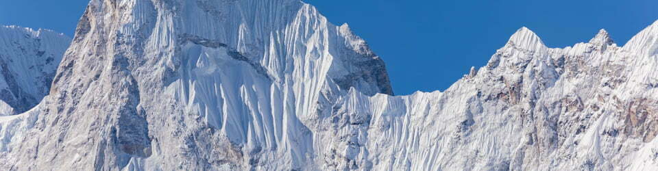
We passed The Spit where the harbour mouth narrows and the water colour deepens, then traced the coastline along Otekiho Beach and Pilots Beach. The volcanic cliffs rise steeply from the water here, with caves and rock ledges lining the shore. Bull kelp (Durvillaea antarctica) clung thickly to the rocks at the waterline, swaying with the gentle swell. Kelp Gulls (Larus dominicanus) patrolled the shoreline, and shags were everywhere — Stewart Island Shags (Leucocarbo chalconotus) diving and preening on ledges along the cliffs.

Amongst other photographically recorded observations during this walk, we were able to confirm sightings of each of the following species: Long-nosed Fur Seal (Arctocephalus forsteri) New Zealand Bull Kelp (Durvillaea antarctica), Kelp Gull (Larus dominicanus), Northern Royal Albatross (Diomedea sanfordi)
Stewart Island Shag, (Leucocarbo chalconotus), Northern Royal Albatross (Diomedea sanfordi)
Wild Adventures Facebook Group
Clickable icons on this world map will open the related trip report
A detailed, searchable trip list with links to reports, photo galleries
From Monarch’s Tour Guide
MONARCH – WILDLIFE CRUISES & TOURS
MV Monarch
Launched in Picton 1952, she originally served as a fishing vessel the South Island. and as a general cargo vessel, working in several locations around
The MV Monarch arrived in Dunedin in 1985, and now takes lucky passengers down the harbour to see wildlife and scenery.
Otago Harbour
Dunedin’s hills are part of an extinct shield volcano. The harbour lies on a faultline which formed a long valley that filled with water as sea levels rose.
It is roughly twenty-two kilometres long and is quite shallow with a tidal range of around two metres. At low tide, around thirty percent of the harbour dries out, revealing large tidal flats which provide food for a large variety of invertebrates, birds and local people.
Northern Royal Albatross (toroa)
These amazing gliders are one of the world’s largest flying birds, with wingspans of around three metres. Recorded flying at speeds over one hundred kilometres per hour, they can travel upwards of four million kilometres in their lifetime.
Adult birds only breed every second year. Eggs are laid in November and hatch in late-January. Chicks will take their first flight in September and spend the next four to six years at sea before returning to Taiaroa Head, the world’s only mainland nesting colony of royal albatross.
Taiaroa Head / Pukekura
Once the site of a significan Mãori på, it is now home to the Northern Royal Albatross breeding colony and a historic lighthouse, built in 1871.
New Zealand Fur Seal (kekeno) Fur seals were almost wiped out by sealers in the early 1800’s, but populations are now steadily increasing. Breeding rookeries are found on rocky outcrops along the coast.
Large males can weigh up to one hundred and eighty kilograms. Their diet consists thirty kilometres per hour. Females can dive deeper than any other seal species, down mostly of squid and octopus. NZ fur seals are fantastic swimmers, reaching speeds of to around two hundred metres, staying underwater for up to fifteen minutes.
The local landscape features, geology, scenic highlights, flora, fauna, Indigenous history, white history and other nearby walks in the area (Perplexity AI Model)
Landscape features
The Eden Wildlife Cruises route follows the main channel of Otago Harbour from the inner peninsula out to the exposed headland of Pukekura / Taiaroa Head and into adjacent coastal waters. The harbour itself occupies a long, narrow drowned valley aligned roughly north‑east to south‑west, contained by the high volcanic ridge of the Otago Peninsula to the south and lower hills to the north. Te Rauone Beach and The Spit represent low, sandy margins on the harbour’s southern shore, where tidal processes and sediment supply have built beaches and sandflats that contrast with the cliffs and rocky points nearer the entrance. Towards Otekiho Beach, Pilots Beach and Taiaroa Head, the land steepens into high, rugged slopes and near‑vertical cliffs that fall directly to the sea, providing ledges, caves and rock platforms used by seabirds and marine mammals. Beyond the harbour mouth, the South Pacific Ocean presents a more open seascape of rolling swell, offshore reefs and contrasting water masses where currents and tidal flows converge.
Geology
Otago Harbour and the Otago Peninsula, including Pukekura / Taiaroa Head, form part of the Dunedin volcanic complex, a Miocene shield volcano whose erosion has left a distinctive combination of ridges, embayments and headlands. The peninsula ridge represents remnants of lava flows and intrusive bodies, while the harbour marks a subsided and subsequently drowned valley aligned along structural weaknesses within the volcanic edifice. At Taiaroa Head, steep cliffs expose basalt and associated volcaniclastic rocks that have been shaped by marine erosion into caves, arches and stepped ledges. Wave action, weathering and mass movement continue to modify these faces, supplying boulders and coarse debris to nearshore platforms and creating a range of microhabitats along the shore. Sandy environments such as Te Rauone Beach and The Spit represent more recent depositional landforms, built from sediment redistributed by tides and waves within the sheltered harbour system.
Scenic highlights
The scenic qualities of this cruise derive from the interplay of harbour, headland and open ocean. Initial sections offer long perspectives along the sheltered waters of Otago Harbour, with the high spine of the Otago Peninsula on one side and lower rural landscapes on the other. Te Rauone Beach and The Spit introduce a quieter, more horizontal aesthetic of sandflats, shallow channels and reflected light, contrasting with the increasingly vertical forms of cliffs and bluffs closer to the harbour mouth. Pilots Beach provides intimate views of rocky shore, small beach and adjacent slopes, often animated by penguins, shags and seals. Around Taiaroa Head, the lighthouse, defence structures and visitor facilities sit atop dramatic cliffs, while offshore waters host sweeping flights of northern royal albatross and other seabirds that accentuate the headland’s exposure. Beyond the entrance, views widen to encompass the open South Pacific, distant coastline and, in good visibility, the broader curve of the east coast of Te Waipounamu.
Local flora
Terrestrial vegetation visible from the cruise reflects both natural patterns and historic land use on the Otago Peninsula. Steeper slopes near Taiaroa Head retain patches of coastal shrubland and small remnant forest, interspersed with pasture and introduced plantings around settlements and the lighthouse precinct. These communities include hardy coastal shrubs and grasses adapted to salt spray, wind exposure and thin soils over volcanic rock. On lower, more sheltered shores around Te Rauone Beach and similar locations, dune and back‑beach vegetation has been modified by development, but restoration efforts are underway in places to stabilise sands and re‑establish native plants. In the marine environment, kelp and other seaweeds form dense bands on rocky substrates, particularly near the harbour mouth and headland, where clear, well‑flushed water and strong currents support extensive algal growth that underpins local food webs.
Local fauna
Pukekura / Taiaroa Head and adjacent harbour waters support an unusually rich assemblage of seabirds and marine mammals. The headland is renowned as the only mainland breeding site of the northern royal albatross in the Southern Hemisphere, with nesting birds and soaring adults visible seasonally above the cliffs. Pilots Beach hosts the largest colony of little or blue penguins on the Otago Peninsula, and nearby habitats are important for the threatened yellow‑eyed penguin. New Zealand fur seals and New Zealand sea lions haul out on rocky ledges and boulder shores around the headland and outer harbour, often in numbers easily observed from passing vessels. Additional seabirds include shags, gulls, terns, petrels and shearwaters, many of which nest on the cliffs or feed in tidal convergence zones at the harbour entrance. The broader harbour also supports wading birds and occasional visits by dolphins and large whales, whose sightings have increased in recent decades, underscoring the ecological importance of this coastal system.
Indigenous history
Taiaroa Head, Pukekura and Otago Harbour lie within Ōtākou, part of the rohe of Kāi Tahu, with Kāi Tahu ki Ōtākou holding mana whenua over the area. For Māori, the harbour, headland and surrounding seas are embedded in whakapapa, voyaging narratives and resource use traditions that connect people, ancestors and place. Pukekura was the site of an important pā, strategically located to control access to the harbour and to oversee fishing grounds, travel routes and interactions with visiting groups. Place names, customary practices and contemporary treaty‑based arrangements continue to recognise these values, with Kāi Tahu perspectives reflected in management of wildlife, heritage and tourism at Taiaroa Head and across the Otago Peninsula.
White history
Following sustained Māori occupation, Taiaroa Head became a focal point of colonial interest as a navigational landmark, military site and symbol of emerging settlement at Dunedin. A lighthouse, completed in the mid‑nineteenth century, marked the harbour entrance for shipping, while later coastal defence works reflected anxieties about international conflict and the need to protect port facilities. Over time, military and navigational roles diminished and conservation and tourism values came to the fore, particularly with recognition of the significance of the northern royal albatross colony. The establishment of the Pukekura / Taiaroa Head Nature Reserve, guided tours, wildlife cruises and interpretive centres has transformed the headland into a premier wildlife and heritage destination, even as remnants of fortifications and historic infrastructure remain visible on the landscape.
Clickable icons on this world map will open the related trip report
A detailed, searchable trip list with links to reports, photo galleries
![]()