
Friday 6/03/2026 Tunnel Beach Car Park, Green Island Bush Road – Tunnel Beach Walk – Tunnel Beach – Tunnel (hand-carved, 1870s) – Natural Rock Arch – Clifftop Track – Forbury Head – Blowhole – Second Beach – Second Beach Track – St Clair Esplanade / St Clair Beach (Whakahekerau
Tunnel Beach Recreation Reserve (Doc) / South Dunedin Coastal Cliffs
Otago Region, NEW ZEALAND (Aotearoa)
Ngãi Tahu / Kãi Tahu Country (Ngãi Tahu / Kãi Tahu people)
Participants: Beth Davies, Stephen Davies (Photos), Sue Davies (Report), Pablo Ureña Vega
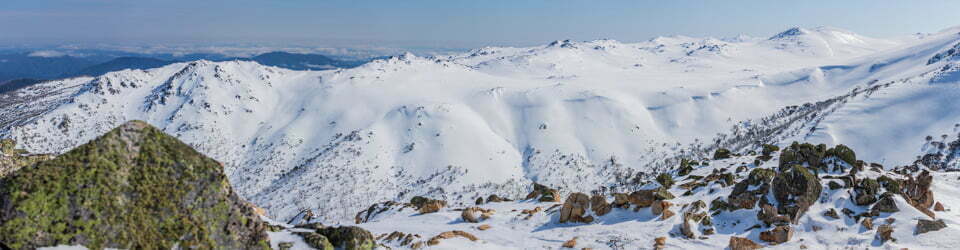
From the gravel car park at the end of Green Island Bush Road — a clifftop paddock perched some 139 metres above the Southern Ocean — the Tunnel Beach Walk plunges immediately downhill on a well-formed, steep gravel single track. Five successive viewpoints, each a fenced clifftop “nest”, serve up progressively wider panoramas of sculpted sandstone headlands.
Max elevation: 159 m
Total climbing: 194 m
Total descent: -314 m
Average speed: 20.84 km/h
Total time: 01:13:32
Behind a low barrier near the third nest, a carpet of critically endangered native coastal turf — selliera, shore cotula, sea primrose and slender clubrush — covers the headland in a deceptively lawn-like mosaic, with a total extent of a mere 40 hectares. Variable oystercatchers worked the rocks below while spotted shags lined the cliff ledges in rows.

Coastline next to Tunnel Beach
At the track’s end, 72 steps descend through the hand-carved 1870s Cargill tunnel into a secluded cove hemmed by 60-metre cliffs. The return climb is honest — 194 metres total — before the clifftop traverse east rewards with open coastal views. At Second Beach, dramatic hexagonal basalt columns frame a sheltered cove. The well-benched Second Beach Track leads the final 800 metres to Barnes Lookout and out onto St Clair Esplanade.
Wild Adventures Facebook Group
Clickable icons on this world map will open the related trip report
A detailed, searchable trip list with links to reports, photo galleries
The local landscape features, geology, scenic highlights, flora, fauna, Indigenous history, white history and other nearby walks in the area (Perplexity AI Model)
Landscape and Physical Geography
The south Dunedin coastal cliffs form a dramatically sculpted littoral zone extending approximately 7 kilometres along the Pacific Ocean shoreline, from the locality of Tunnel Beach in the west to Lawyers Head in the east. The cliffs range in height from approximately 30 to 60 metres above sea level, with the inland promontory of Forbury Hill rising to 159 metres immediately above the suburb of St Clair (Whakahekerau). The coast is characterised by a succession of rocky headlands, small coves, sea caves, and natural arches, all carved from the alternating layers of Miocene sandstone, limestone, and volcanic basalt by the unceasing action of the Southern Ocean. Tunnel Beach itself lies at the base of approximately 60-metre sandstone cliffs, accessible only through a tunnel hand-carved in the 1870s. Second Beach, immediately west of St Clair, is a partially enclosed rocky cove sheltered by its headland from the prevailing southwesterly swells. St Clair Beach (Whakahekerau) is the principal surf beach of Dunedin, oriented broadly east–west along the southern urban coast, and backed by the low coastal plain of South Dunedin, an area of formerly marshy reclaimed land susceptible to periodic inundation.
Geology
The south Dunedin coast provides one of the finest accessible cross-sections through the Dunedin Volcanic Complex, an extensively eroded multi-vent shield volcano active between approximately 16 and 10 million years ago during the Miocene epoch. The basement rock of the wider Otago region is Otago Schist, a metamorphic rock formed approximately 150 million years ago during the Rangitata orogeny. Overlying the schist are a series of Cretaceous and Tertiary marine sedimentary rocks, including the Abbotsford Formation (a friable sandstone and mudstone sequence), and Miocene-age limestones which contain well-preserved marine fossils including brachiopod shells, echinoderm fragments, and whale bones — all readily observable at Tunnel Beach. These sedimentary sequences were intruded and overlain by volcanic rocks of the Dunedin Volcanic Complex, including basalt flows, phonolite, and trachyte. The spectacular hexagonal basalt columns at Second Beach and Blackhead headland — comparable in form to the Giant’s Causeway in Northern Ireland and Fingal’s Cave in Scotland — were formed as basaltic lava flows cooled and contracted, generating a regular pattern of columnar jointing. The Blackhead headland, approximately 3 kilometres west of Tunnel Beach, was described by early European observers as deserving equal fame to those celebrated Scottish and Irish formations. The coast also features a natural blowhole at Forbury Head, where wave action forces air and water through a fissure in the volcanic rock. Post-glacial sea-level rise of approximately 120 metres since the last glacial maximum (approximately 20,000 years before present) flooded former river valleys and created the current coastal configuration.
Scenic Highlights
The south Dunedin coastal cliffs offer some of the most dramatic coastal scenery in Otago. From the five “nest” viewpoints along the Tunnel Beach Walk, walkers are presented with panoramic views of the Southern Ocean, the sculpted sandstone headlands and sea arches, and the distant silhouette of the Otago Peninsula to the northeast. From the clifftop track above Second Beach, the panoramic view extends eastward along the coast as far as Lion’s Head Rock and Tow Rock at the entrance to Sandfly Bay, approximately 18 kilometres distant. On exceptionally clear days such as 6 March 2026 — when AccuWeather records indicate a maximum temperature of 30°C, far above the March average — the full sweep of Dunedin’s southern coastline and the Otago Peninsula is visible. Cargill’s Castle ruins, perched on their windswept clifftop promontory, form a striking architectural landmark against the Pacific Ocean horizon, and constitute New Zealand’s only ruined castle.
Flora
The south Dunedin coastal clifftops support a critically endangered plant community known as native coastal turf, which occurs only in New Zealand and is classified as Threatened – Nationally Critical, with a total surface area in Aotearoa New Zealand of approximately 40 hectares. This community grows on thin soils derived from volcanic and sedimentary parent material, exposed to salt-laden coastal winds. Its principal component species include remuremu (a creeping coastal plant), shore cotula, sea primrose, slender clubrush, glasswort, and native celery, with rarer species including Buchanan’s orache and the white-flowered coastal gentian. The area is also characterised by introduced grasses, gorse, broom, and marram grass on the dunes and open clifftop land. Native shrub species including kānuka and flax (harakeke) occur in sheltered gullies and along roadsides. Tī kōuka (cabbage tree) is a prominent landscape feature along the coastal margins. The wider south Dunedin lowland was, prior to European settlement, covered by dense flax, fern, and formerly forested in parts — evidenced by wood remains uncovered during 19th-century land reclamation works.
Fauna
The south Dunedin coastal zone supports a diverse assemblage of seabirds and marine mammals. Spotted shags nest on the sandstone and basalt cliffs, while variable oystercatchers forage along the rocky shoreline. Southern black-backed gulls are ubiquitous, and red-billed gulls and white-fronted terns are commonly observed offshore. New Zealand fur seals and New Zealand sea lions are documented visitors to Tunnel Beach, where they rest on the boulders above the tide line. The wider Dunedin coast is within the foraging range of the endangered yellow-eyed penguin, and little blue penguins nest at several locations along the Otago Peninsula. Moa hunter archaeological sites at St Clair and St Kilda provide evidence of the former presence of multiple moa species in the Dunedin coastal lowlands; these were hunted to extinction within approximately a century of Polynesian arrival. Hector’s dolphins, New Zealand’s endemic and critically endangered small dolphin, are occasionally observed in the inshore waters off the south Dunedin coast.
Indigenous History
The south Dunedin coastal zone lies within the takiwā (tribal territory) of Ngāi Tahu (Kāi Tahu), the principal iwi of Te Waipounamu (the South Island). Archaeological evidence indicates that the first Māori occupation of the wider Dunedin area occurred within decades of Polynesian arrival in New Zealand, estimated at approximately 1280–1320 CE. The earliest inhabitants are identified archaeologically as moa hunters, and their settlements were concentrated along the southern coast of the Dunedin area, where they relied principally on moa, seals, and coastal marine resources. Moa hunter sites have been identified at St Clair (Whakahekerau) and St Kilda (Rakiātea), and a traditional Māori pathway (ara) ran along the sandhill ridges and clifftops of the south coast, linking the Otago Peninsula to the Taieri coast to the south — following the same route that the modern Tunnel Beach to St Clair clifftop walk traverses. The land at what is now Cargill’s Castle was known to Māori as Whakaherekau. The Ōtākou Rūnaka records that moa hunter sites existed at Andersons Bay, St Kilda, and St Clair, and that Māori tracks around Lawyers Head gave access to the coastline and the Taiari River plains. Following the successive migrations of Waitaha, Kāti Māmoe (Ngāti Māmoe), and Kāi Tahu peoples into the south (the latter becoming dominant from the mid-17th century), the area formed part of the mahinga kai (food-gathering) network of the Ōtākou people. The Otago Block was purchased from Kāi Tahu by the New Zealand Company in 1844 for £2,400, and European settlement of the Dunedin area proceeded rapidly from 1848.
European History
The south Dunedin coastal cliffs entered the European record in 1770 when Captain James Cook sighted the Otago coast during his first Pacific voyage, though he did not land. European sealers were operating along the Dunedin coast by approximately 1809, and the Sealers’ War — a protracted series of violent confrontations between Māori and European sealers — unfolded partly in these waters between approximately 1810 and 1823. The first permanent European settlement at Dunedin was established in 1848 by Free Church of Scotland migrants, and the city rapidly expanded across the southern coastal plain during the Otago gold rush of the 1860s. The Tunnel Beach locality takes its name from the tunnel commissioned in the 1870s by John Cargill, son of city founder Captain William Cargill, to give his family private access to the secluded beach below the cliffs. John Cargill’s brother, Edward Bowes Cargill, a prominent businessman and politician, built the grand Italianate mansion known as The Cliffs (later Cargill’s Castle) on the clifftop above St Clair in 1877 at a cost of £14,000. Designed by architect Francis Petre, the 21-room mansion was gutted by fire in 1892 and never fully restored; subsequent owners operated it as a restaurant, cabaret, and venue for religious worship before its acquisition by the Cargill’s Castle Trust in 2001. It is listed as a Heritage New Zealand Category I historic place. The cliffs above Second Beach were fortified with a coastal gun battery from the 1880s until the end of World War I, as part of a New Zealand-wide system of coastal defences prompted by concerns over Russian naval threat; no physical trace of the battery remains. The Second Beach Track traverses land that was the site of Shiel’s Brickmaking quarry operations from approximately 1901 until the 1930s. The St Clair hot saltwater pool, a Dunedin institution, has operated at the St Clair beachfront since 1884.
Clickable icons on this world map will open the related trip report
A detailed, searchable trip list with links to reports, photo galleries
![]()