
Friday 13/03/2026 Slope Point Road – Slope Point – Slope Point Light Beacon Station – The Southern Most Point of New Zealand
Slope Point walking track (informal farm access route across private farmland)
Private farmland at Slope Point
The Catlins
Southland Region, NEW ZEALAND (Aotearoa)
Murihiku Country (Ngāi Tahu people)
Participants: Beth Davies, Stephen Davies (Photos), Sue Davies (Report), Pablo Ureña Vega
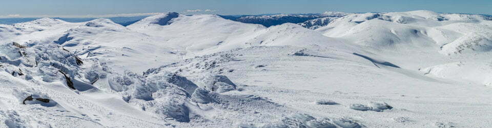
We drove to the end of Slope Point Road on a cool, breezy March morning. A small car park marks the start of an informal farm track across private grazing land — you need to check the gate is closed behind you. The route is a faint track threading between fence lines with sheep grazing either side. It’s flat, easy going on firm but slightly damp ground from recent showers. A steady amble rather than a hike, though the sense of exposure grows as you approach the cliff edge.
Max elevation: 49 m
Total climbing: 29 m
Total descent: -32 m
Average speed: 3.91 km/h
Total time: 00:40:23
By mid-morning the forecast showers were brushing through in short bursts on a brisk southerly, with bands of sunlight chasing the clouds across the sky. Ahead, twisted, wind-sculpted trees and the low profile of the solar-powered light beacon mark the approach to the cliff.

Slope Point
At the edge, the famous AA signpost stands above the surge — its arrows pointing to the Equator and the South Pole. There is nothing between you and Antarctica but open ocean and a scattering of distant islets. The wind roars in your ears and the salt spray hangs in the air. It is a raw, windswept place — the southernmost point of mainland New Zealand. An easy, short walk to a genuinely dramatic destination. Well worth the detour if you’re in the Catlins.
Wild Adventures Facebook Group
Clickable icons on this world map will open the related trip report
A detailed, searchable trip list with links to reports, photo galleries
Information on Parks signage along the way
NAU MAI HAERE MAI KI WAIPÖHATU
WELCOME TO SLOPE POINT
THE SOUTHERNMOST POINT OF THE SOUTH IŞLAND, AOTEAROA NEW ZEALAND.
The aurora australis (southern lights) can sometimes be seen in the night sky here.
Titiro whakamua kiTe Ara a Kiwa, Motupöhue, Hananui, Rakiura, Ruapuke me ngā motu titi. Ko te maunga me te whenua kei muri e möhiotia ana ko Te Kahui Tipua me Waipöhatu. Kia aio tõ noho mai i a koe e torotoro ana i ngã tini taonga o Waipöhatu.
Look infront of you to see Te Ara a Kiwa, Motupöhue, Hananui, Rakiura, Ruapuke, and the Titi Islands. The mountain and land behind you is known as Te Kahui Tipua and Waipöhatu. Enjoy your stay while you explore the many treasures of Waipóhatu.
New Zealand’s southernmost shipping lane lies in the seas before you. With around 300 commercial vessels travelling to Bluff each year, most will travel past Slope Point. Local fishing operators ply their trade here too.
Ururangi
Ururangi (Merope) is a male star Mãori associate with wind and is connected to the nature of winds and atmospheric conditions for the year.
Expert Mãori astronomers will observe its appearance during the rising of Matariki in the Mãori New Year to predict how the winds and weather might affect the land and sea, and the productivity of water and land resources.
Matariki (Pleiades), is a star cluster called Te Kahui o Matariki. Its appearance with Puaka (Rigel) before the sunrise in the north-east during mid-winter signifies the Mãori new year (Matahi o te Tau). Its arrival is a sign for people to gather, honour the dead, celebrate the present and make plans for the future. It is an indicator for the wellbeing of people, and the environment. Matariki is also the name of the brightest star in the centre of the cluster. She was taken by Rehua (Antares) as a wife and gave birth to eight children (five daughters and three sons): Pöhutukawa (Sterope), Tupuänuku (Pleione), Tupuärangi (Atlas), Waiti (Maia), Waita (Taygeta), Waipunarangi (Electra), Ururangi (Merope), and Hiwa-i-te-rangi (Calaeno).
Matariki Wayfinding Journey
Southland District Council, in partnership with Te Ao Marama, invite you to explore the treasures of Murihiku by following the stars in Te Kähui o Matariki and Puaka via our Matariki Wayfinding Journey. This wayfinding experience will guide you through parts of our region, visiting locations and stops on the way to learn more about Mãori astronomy, cultural narratives and history, places of significance, local stories, flora, and fauna. Scan the QR code above to get more information about the Matariki Wayfinding Journey.
This wayfinding journey was co-funded by the Ministry of Business, Innovation and Employment’s Tourism Infrastructure Fund (TIF) and the Southland District Council.
Artist – Steve Solomon
Ngãi Tahu, Ngäti Mâmoe, Waitaha, Te Arawa, Te Whänau-ā-Apanui
Ururangi, the wind star, is connected to Waipunarangi, the rain star, and has a relationship with Tawhirimatea, the weather god.
This pou at Slope Point is in a place of conflict between the sea and the land. The design depicts Ururangi racing in over the sea, stirring up white water and creating spray from the waves, before hitting the land with force, pushing trees and grasses aside and permanently casting them in place.
The colours are naturalistic, as the wind cannot be seen. On the wide maihi (barge boards) tree-like fingers can be seen. The amo (side posts) are in the form of maeroero, ghostly figures from the bush who warn people to stay away. In the brow of the koruru (mask), toroa (albatross) can be seen soaring in the wind. The circles in Ururangi’s fingers represent the bright stars of Tautoru and Te Kakau (Orion’s Belt), with the fingers pointing upwards towards Puaka.
The local landscape features, geology, scenic highlights, flora, fauna, Indigenous history, white history and other nearby walks in the area (Perplexity AI Model)
Landscape and geology
The landscape around Slope Point is a low, gently sloping table of farmland ending abruptly in steep cliffs that fall to the Southern Ocean. These cliffs are carved into sedimentary rocks that form part of the coastal band fringing the southern edge of Te Waipounamu, shaped over time by marine erosion, salt‑laden winds and persistent wave energy. The broad surface inland has been levelled and drained for agriculture, but the cliff tops retain an open, windswept character with minimal shelter, emphasising the transition from cultivated land to wild coast within only a few hundred metres. The wider South Island topography places this coastal platform at modest elevation above sea level, framed to the distant north by higher ranges that testify to the region’s ongoing tectonic uplift.
Scenic highlights
The primary scenic highlight is the viewpoint at the southernmost point of the South Island, where the AA signpost marks distances to the Equator and the South Pole against a backdrop of open sea. The small solar‑powered light beacon and the geodetic marker add human scale to an otherwise expansive maritime horizon. Visitors observe dramatic seas breaking against the rock platforms at the foot of the cliffs, with the sense of remoteness heightened by the absence of nearby settlements and by the exposure to strong prevailing winds. The approach across open paddocks, punctuated by the famous line of wind‑sculpted trees often photographed in the area, creates a gradual reveal of the coast that is visually and atmospherically distinctive.
Local flora
The immediate environs of the track traverse improved pasture dominated by grazed grasslands maintained for sheep farming, reflecting extensive modification of the original vegetation. Along fence lines and around the car park, low, hardy shrubs and shelter trees show clear wind pruning, with branches streaming inland under the influence of persistent southerlies, a common visual motif in this part of Southland. Remnant coastal vegetation persists in more sheltered niches along the cliff edge and gullies, though it is fragmented by agricultural use and exposure, illustrating the tension between farming and the conservation of native coastal plant communities. The broader Catlins region, of which Slope Point forms a southern extremity, is known for richer coastal forest and wetland systems, but these more diverse assemblages lie beyond the immediate farmland crossed on this short walk.
Local fauna
The coastal waters off Slope Point form part of a rich marine environment that supports seabirds, marine mammals and commercially important fish stocks, with the wider management area recognised in regional fisheries and marine planning documents. From the cliff tops, observers may see seabirds using the updrafts along the coast and, in suitable conditions, marine life such as dolphins or seals moving through the near‑shore zone, though such sightings are variable and not guaranteed on any particular visit. Agricultural use of the land introduces domesticated animals, especially sheep and sometimes cattle, which are integral to the visual and acoustic character of the approach to the headland. Seasonal access restrictions during lambing reflect a management approach that seeks to balance visitor demand with animal welfare and farm operations.
Indigenous history
Slope Point sits within Murihiku, the wider southern region associated with Ngāi Tahu and its papatipu rūnanga, who maintain enduring relationships with the coasts, fisheries and landscapes of Southland. Māori history along this coast includes long‑distance travel by waka and on foot, extensive use of marine resources and complex patterns of settlement and seasonal occupation linked to fishing grounds and access routes to prized stone such as pounamu. Regional planning documents emphasise concepts such as kaitiakitanga and the recognition of cultural narratives, which are increasingly expressed through interpretive projects and wayfinding initiatives that incorporate Māori perspectives into contemporary infrastructure. Recent collaborative projects, such as the Matariki wayfinding pou network that includes Slope Point, further embed local stories and indigenous knowledge into visitor experiences along the southern coast.
White history
European engagement with the Slope Point area is closely tied to pastoral farming, coastal navigation and later tourism along the Southern Scenic Route. The establishment of sheep farming transformed much of the original vegetation into pasture, with farm tracks and fence lines structuring access to the headland that visitors now follow on foot. The construction of the small light beacon and the installation of the AA signpost reflect efforts to support maritime safety and to formalise the site’s status as an extreme point of the country, drawing increasing numbers of travellers. Recent council projects to improve Slope Point Road and develop modest visitor infrastructure, undertaken in partnership with mana whenua, illustrate an evolving approach that seeks to accommodate tourism while acknowledging both environmental constraints and cultural histories.
Clickable icons on this world map will open the related trip report
A detailed, searchable trip list with links to reports, photo galleries
![]()