Category Archives: Panorama

Ngaro Track – Whitsunday Islands National Park

10/06/2026 – 12/06/2026    Whitehaven Beach South – Solway Circuit – South Whitehaven Beach Lookout – Solway Passage – Chance Bay Walk – Chance Bay – Nargo Track – Chance Bay Campsite – Theos Point Lookout – Bari Dhil Lookout – Camp 1: Bowarri yamba (Moon Camp) – Craig Point Lookout – Whitsunday Craig Lookout – Whitsunday Craig – Bilbili dhilli Lookout – Crayfish Bay Lookout – Camp 2: Dhula yamba (Tree Camp) – Torres Herald Bay – Gumi – Murmuru bari Lookout – Hill Inlet Lookout Platform – Bettys Beach – Tongue Point

                                                  Ngaro Track

                                                  Whitsunday Islands National Park, QUEENSLAND

                                                  Ngaro Country (Ngaro people)                     

Distance: 35.7km   Total Ascent: 1495m   Total Descent: 1463m

Time: 18 hours 

Participants:  Matt Aistro, James Anthony, Stephen Davies (Photos), Sue Davies (Report), Katie, Cecelia McLoughlin, Matt Madin, Rachel, Kylie Shirvington, Philip Whitmore, Summer and River [15 altogether]

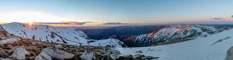
Three unforgettable days on the Ngaro Track delivered everything you could want from a Whitsunday Islands adventure—wild weather, sweeping island vistas, rich cultural landscapes, and a constantly changing mix of coastal and forest environments. Starting with a rough, rain-soaked boat ride to the dazzling white sands of Whitehaven Beach, this journey quickly set the tone for a challenging and rewarding trek across Ngaro Country.

Covering 35.7 km with significant elevation gain, the track links secluded bays, panoramic lookouts, ancient hoop pine forests, mangrove wetlands, and pristine beaches. Each day revealed something new—from ridge-top camps overlooking turquoise waters to close encounters with remarkable wildlife. Shared with a great group of walkers, this hike was as much about camaraderie as it was about the landscape, with every step offering another reason to pause, photograph, and take it all in.

Continue reading

Loading

Eastern Tracks – Hamilton Island

Monday 8/06/2026   Eastern Tracks

                                      Hamilton Island, QUEENSLAND

                                      Ngaro Country (Nargo people)                        

Participants: Stephen Davies (Photos), Sue Davies (Report)

We started the day with a civilised cuppa at the Sails Cafe before walking along Catseye Beach with views of our destination at Passage Peak. We took the Scenic Trail to Saddle Junction with the aim of walking to Middle Head first. There was some confusion with the trail signage, with some backtracking before we reached the pleasant views from Middle Head. There were very few people on these wide pleasant trails.

Continue reading

Loading

Western Tracks – Hamilton Island

Saturday 6/06/2026   Western Tracks

                                        Hamilton Island, QUEENSLAND

                                        Ngaro Country (Nargo people)                         

Participants: Stephen Davies (Photos), Sue Davies (Report)

After completing the 7:00am parkrun there was still plenty of time to hit the trails. There are 20km of trails on the island and it’s our aim to complete all of these during our stay.

Continue reading

Loading

Lee Bay – North Arm – Port William – Oban – Rakiura Track – Stewart Island

18/03/2026 – 20/03/2026   Lee Bay Road – Lee Bay – Mãori Beach – Wooding Bay – Magnetic Beach – Port William – Port William Hut – North Arm Hut – North Arm – Sawdust Bay Campsite – Kaipipi Road – Ryans Creek Track – Main Road – Kairakau / Halfmoon Bay – Oban

                                                 Rakiura Track

                                                 Stewart Island / Rakiura

                                                 Southland Region, NEW ZEALAND (Aotearoa)

                                                 Rakiura Country (Ngãi Tahu people)        

Distance: 38.6km   Total Ascent: 1275m   Total Descent: 1296m

Time: 15 hours 

Participants:  Stephen Davies (Photos), Sue Davies (Report)

Stepping through the great iron chain at Lee Bay felt like walking across the anchor of an ancient story, the bush and sea already sharing their secrets on the wind. The Rakiura Track here is a gentle, well‑benched path, undulating above the rocky shoreline before slipping into deep, damp forest where rimu and southern rātā lean over the track and the air smells of salt and leaf mould. Underfoot it was mostly firm gravel with the odd muddy patch in hollows, never technical but always asking you to watch your step.

Continue reading

Loading

Diamond Lake – Rocky Mountain – Queenstown Lakes District

Monday 2/03/2026   Diamond Lake Car Park – Wānaka–Mt Aspiring Road – Diamond Lake Loop Track – Lower Circuit Track – Lake Wānaka Lookout Track – Rocky Mountain Track – Diamond Lake Bird View – Lake Wānaka Lookout – Diamond Lake – Schist bluffs – Rocky Mountain (775 m) – Kā Tiritiri o te Moana / Southern Alps – Mount Aspiring / Tititea (3,033 m) – Lake Wānaka – Mou Waho – Mou Tapu – Te Peka Karara – Ruby Island – Glendhu Bay – The Peninsula – Diamond Lake Car Park

                                        Diamond Lake and Rocky Mountain Track

                                        Diamond Lake Conservation Area, Queenstown Lakes District, Otago, NEW ZEALAND (Aotearoa)

                                        Kāi Tahu ki Otago Country (Ngāi Tahu / Kāi Tahu)

Participants: Beth Davies, Stephen Davies (Photos), Sue Davies (Report),  Pablo Ureña Vega

We decided to do a slightly easier walk today after a big climb on the previous days. It was a 20-minute drive from Wanaka to the trailhead, and there was plenty of parking.

The trail climbed up from the carpark, and we were soon passing Diamond Lake, of which we had excellent views a little further along the trail. Looking from above, the dark waters of the lake were very picturesque.

Continue reading

Loading

Rob Roy Glacier Track – Mount Aspiring

Wednesday 4/03/2026   Wanaka Mount Aspiring Road – Matukituki River West Branch – Raspberry Creek Carpark – Rob Roy Stream – Rob Roy Glacier Track – Bridal Veil Falls – Rob Roy Glacier 

                                            Fiordland National Park / Te Wāhipounamu

                                            South West New Zealand World Heritage Area, Southland, NEW ZEALAND (Aotearoa)

                                            Tahu Country (Ngāi Tahu / Kāi Tahu people)

Participants: Beth Davies, Stephen Davies (Photos), Sue Davies (Report),  Pablo Ureña Vega

It is about a one-hour drive from Wanaka to the Raspberry car park. There is about 30km of gravel, as well as a few shallow (at this time of year) fords. We arrived at about 10:00am at the already busy car park.

Continue reading

Loading

Isthmus Peak – Queenstown Lakes District

Tuesday 3/03/2026   Isthmus Peak Track Carpark – Stewart Creek – Glen Dene Station – Dinner Creek – Dinner Flat – Ridge Junction – Glen Dene Ridge Track junction – Isthmus Peak (1,385 m)

                                       Isthmus Peak Track

                                       Matatiaho Conservation Area, Glen Dene Station (private land)

                                       Queenstown Lakes District, Otago, NEW ZEALAND (Aotearoa)

                                       Kāi Tahu (Kāi Tahu, Kāti Māmoe, Waitaha) Country (Kāi Tahu people / Te Rūnanga o Ngāi Tahu)


Participants: Beth Davies, Stephen Davies (Photos), Sue Davies (Report),  Pablo Ureña Vega

It was a 30-minute drive from Wanaka to the trailhead of Isthmus Peak. The recommendation was to arrive early as the carpark is not large. That was an understatement, but if people had parked appropriately, many more cars would fit there. We were lucky to get the last spot.

It was almost 9:30am by the time we set off in the cool, clear morning, which promised to turn into a stunning day. It certainly didn’t disappoint us!

Continue reading

Loading

Ben Lomond Track – Queenstown

Friday 27/02/2026   Bob’s Peak / Skyline Gondola Top Complex (787m) – Skyline Access Road – Luge Track crossing – Ben Lomond Track – Douglas fir forest zone – Alpine tussock zone (treeline ~800m) – Ben Lomond Saddle (1,326m) – Moonlight Track junction – Ben Lomond Station (private land) – Ben Lomond / Te Taumata-o-Hākitekura Summit (1,748m) with rock cairn (built 1960s by Henry Barker) – Ben Lomond Saddle (1,326m) – Ben Lomond Track – Bob’s Peak / Skyline Gondola Top Complex (787m)

                                     Ben Lomond Track

                                     Ben Lomond Scenic Reserve

                                     Queenstown-Lakes District, Otago, South Island, NEW ZEALAND (Aotearoa)

                                     Te Waipounamu – Ngāi Tahu (Kāi Tahu) rohe (Ngāi Tahu / Kāi Tahu people, incorporating Kāti Māmoe and Waitaha)

Participants: Beth Davies, Stephen Davies (Photos), Sue Davies (Report),  Pablo Ureña Vega

We arrived in Queentown late the previous night. With a two-hour time difference and the associated tiredness, we were off to a slow start.

We headed off to find some breakfast and then drove to buy some food for lunch. By the time we walked to the gondola station and reached the top, it was after midday.

Continue reading

Loading

Bullocks Flat – Thredbo River – Perisher Valley

Monday 29/12/2025   Bullocks Flat – Thredbo River – Perisher Valley

                                         Kosciuszko National Park, NSW

                                         Ngarigo Country                         

Participants: Stephen Davies (Photos), Sue Davies (Report), Beth Davies, Pablo Ureña Vega

Beth had suggested we try this newly opened walk. She and Pablo would run in one direction, and we would start at the other and swap keys along the way.

We started under clear skies, and although it was around 8:30am, it was already getting warm, and we were walking uphill!

Continue reading

Loading

Antarctic Peninsula Expedition

9/12/2025 – 19/12/2025    Antarctic Peninsula Expedition

“It is in our nature to explore, to reach out into the unknown. The only true failure would be not to explore at all.” Ernest Shackelton

Participants:  Stephen Davies (Photos), Sue Davies (Report), Cal Stewart, Kerrie Stewart, with 93 staff, and 134 other passengers

Route of MS Seaventure

Antarctic Peninsula Voyage  (Garmin Messenger)

Total distance: 3292.32 km
Max elevation: 487 m
Total climbing: 11633 m
Total descent: -11773 m
Average speed: 16.89 km/h
Total time: 12:41:30
Download file: 20251209Seaventure.gpx                         Track Info

Continue reading

Loading

Huemel Circuit – Santa Cruz Province – ARGENTINA

  2/12/2025 – 5/12/2025  Huemel Circuit

                                             Parque Nacional Los Glaciares (Los Glaciares National Park)

                                             Area Lago Viedma

                                             Santa Cruz Province, ARGENTINA

Distance: 75.8km                                                Time: 34 hours 

Total Ascent: 2695m                                          Total Descent: 2803m

Participants:  Stephen Davies (Photos), Sue Davies (Report), Pedro Navarro (Guide), Patrizia Schäffnerl, Valentina Sobol (Porter)

The Huemul Circuit is not a casual stroll but a full immersion into the raw weather, vast ice and big skies of southern Patagonia.  From the moment our small team left El Chaltén and Monte Fitz Roy faded behind us, daily life was replaced by a rhythm of boggy lenga forest, wind‑buffeted passes, creek crossings and evenings spent drying gear beside lakes. 

Guided by Pedro, with our porter, Valentina, carrying a very heavy pack and an endless supply of good humour, we circled Cerro Huemul above Lago Viedma, twice crossed the Río Túnel by Tyrolean traverses, and crunched over glacial ice while storms and sun took turns sweeping the Southern Patagonian Ice Field.  This report aims to capture an experience that tested creaky knees and comfort zones, but rewarded us with a guanaco on a perfect backdrop, rare orchids, and the quiet satisfaction of finishing one of South America’s toughest and most beautiful treks.

Continue reading

Loading

Bariloche – Refugio Emilio Frey – Laguna Toncek – Laguna Jakob Rucaco – Refugio San Martin – Tambo Báez

27/11/2025 – 29/11/2025  Bariloche – Refugio Emilio Frey – Laguna Toncek – Laguna Jakob Rucaco – Refugio San Martin – Tambo Báez

                                               Parque Nacional Nahuel Huapi 

                                               (Nahuel Huapi National Park)

                                               Rio Negro Province

                                               Patagonia Lakes District

                                               ARGENTINA

Distance: 46.6km            Time:  21.5hours 

Total Ascent: 1692m       Total Descent: 1848m

Participants:  Stephen Davies (Photos), Sue Davies (Report)

A much-anticipated start after multiple delays.

Getting to the start of the walk was an adventure in itself. We were lined up to board our international flight from Sydney to Buenos Aires when the line came to a standstill. The staff were looking stony-faced as they were given the news. There was no announcement, but they came over to the line and started speaking to individuals. We soon learned that our plane had been “struck by lightning” and the flight was cancelled. Great start to our trip! We were offered overnight accommodation if we didn’t live in Sydney and a meal voucher. A few hours later, I received an email saying our flight had been rescheduled for the following day, 27 hours late. We were transferred by bus to the Holiday Inn Sydney Airport, where they were keen to give us free food. Dinner and breakfast were included as well as the shuttle back to the airport. We settled in for the afternoon. 

We did take off at the new time the following day, but I had to adjust our travel plans, accommodations and our flight into Bariloche for the following day. The new flight time, unfortunately, had us waiting for seven hours in Santiago for the connection. We arrived in Buenos Aires close to 10:00pm, and I had organised accommodation close to the airport. Our flight the following day was at 3:15pm, but we had to check out of our accommodation at 10:00am, so we just headed for the airport. We checked our bags in, and soon after, I received an email saying the flight was delayed another six hours! So we had an 11-hour wait at the airport!

We eventually arrived in Bariloche close to midnight and fell asleep as soon as we hit the pillow. 

Continue reading

Loading