
Sunday 15/03/2026 Stewart Island Backpackers – Dundee Street – Fuchsia Walk – Roroa Walk Watercress Beach – Thule Road – Golden Bay Wharf – Golden Bay – Deep Bay Road – Reinga Beach – Petersons Hill Road – Elgin Terrace – Oban
Stewart Island / Rakiura
Southland Region, NEW ZEALAND (Aotearoa)
Rakiura Country (Ngãi Tahu people)
Participants: Stephen Davies (Photos), Sue Davies (Report)
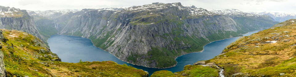
We spent a day wandering the bays and tracks around Oban on Stewart Island on a cool, partly cloudy March afternoon. From the Stewart Island Backpackers we headed along Dundee Street into the Fuchsia Walk — a short climb through native forest to Traill Park, then onto the Raroa Track down to quiet Watercress Bay. The forest track is well-formed with a straightforward descent.
Max elevation: 68 m
Total climbing: 251 m
Total descent: -251 m
Average speed: 2.97 km/h
Total time: 02:36:30
Muttonbird Scrub (Brachyglottis rotundifolia) lined the coastal sections — its silvery leaves a familiar sight on Stewart Island, where it can sometimes be seen along exposed headlands and coastal roads.

Forest near Deep Bay
From Watercress Bay, the route follows quiet roads out Thule Road towards Golden Bay, across to Deep Bay and on to Reinga Beach. Paterson Inlet is never far from sight, the water calm and the far shore a dark green wall of forest. The roads are quiet, and the walking is easy.
The final pull over Peterson’s Hill back into Oban brought a satisfying sense of having stitched together our own little route of Rakiura’s only town. A lovely day — bays, bush and harbour views. A Tūī (Prosthemadera novaeseelandiae) happily sitting in a tree just outside of town provided a perfect end to our “rest” day on Stewart Island.
Amongst other photographically recorded observations during this walk, we were able to confirm sightings of each of the following species: Muttonbird Scrub (Brachyglottis rotundifolia), Tūī (Prosthemadera novaeseelandiae)
Wild Adventures Facebook Group
Trip Post
Clickable icons on this world map will open the related trip report
A detailed, searchable trip list with links to reports, photo galleries
The local landscape features, geology, scenic highlights, flora, fauna, Indigenous history, white history and other nearby walks in the area (Perplexity AI Model)
Landscape features
The immediate landscape around Waipapa Point is a low, windswept coastal terrace ending in a rocky headland and broad sandy beaches. Rolling dunes back the shoreline, with patches of tussock and salt‑tolerant grasses framing views along the Catlins coast. The shoreline is deeply indented, with reefs and rock platforms creating irregular lines of surf and sheltered pockets of calmer water.
Geology
Waipapa Point sits on the southern margin of the South Island, where resistant sedimentary rocks and coastal deposits have been re‑worked by waves, wind and sea‑level changes. The headland and reef represent more durable layers that project into the sea, while surrounding softer materials have been eroded into beaches and low cliffs. Over time, marine processes have carved rock platforms and offshore reefs such as Waipapa Reef, creating the hazards that contributed to historic shipwrecks.
Scenic highlights
Key scenic elements include the white timber lighthouse poised above the reef, the sweeping arc of beach on either side, and the constant motion of heavy Southern Ocean swells. On clear days, long views extend along the Catlins coastline, with layered headlands receding into distance and the sky dominating the horizon. Wildlife adds to the spectacle, with frequent sightings of sea lions on the sand and rock platforms, and seabirds travelling along the coast.
Local flora
The near‑track vegetation is a mosaic of coastal grassland and low shrubs adapted to salt spray and strong winds. Grasses and tussocks stabilise the dunes, while hardy coastal plants occupy hollows and more sheltered pockets behind the foredunes. Close to the car park and lighthouse, mown grass and introduced species reflect long agricultural and navigational use of the site.
Local fauna
New Zealand sea lions are a signature species at Waipapa Point, often visible resting or moving between the beach and inland tussock. Fur seals can also be encountered around the reefs and rock platforms. The coastal environment supports a variety of seabirds and shorebirds that use the area for feeding, roosting and seasonal movements along the Southland coast.
Indigenous history
Waipapa, shortened from the earlier form Waipapapa meaning shallow waters, reflects long Māori engagement with this coast and its marine resources. The wider Catlins and Murihiku region lies within Murihiku, associated with Ngāi Tahu, whose ancestors travelled extensively along Te Wai Pounamu for food, trade and cultural purposes. Coastal camps, journeys and place names attest to a deep connection with fisheries, shellfish beds and sea mammals in this part of the southern ocean margin.
White history
European maritime and pastoral use reshaped Waipapa Point from the nineteenth century onwards. The wreck of the passenger steamer Tararua on Waipapa Reef in April 1881, in which 131 of 151 people aboard died, marked one of New Zealand’s worst civilian maritime disasters and prompted stronger navigational measures. In response, Waipapa Point Lighthouse was built and first lit on 1 January 1884, later automated in 1974, and it continues to operate as a coastal aid to navigation while the surrounding farmland and access roads reflect subsequent European settlement and land use across the Catlins and Southland.
Clickable icons on this world map will open the related trip report
A detailed, searchable trip list with links to reports, photo galleries
![]()