
Sunday 22/03/2026 Queenstown
Queenstown-Lakes District, Otago
South Island, NEW ZEALAND (Aotearoa)
Te Waipounamu – Ngāi Tahu (Kāi Tahu) rohe (Ngāi Tahu / Kāi Tahu people, incorporating Kāti Māmoe and Waitaha)
Participants: Stephen Davies (Photos), Sue Davies (Report)
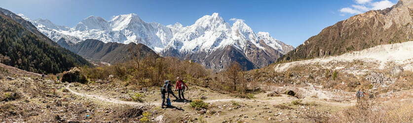
We spent a late-March Sunday wandering around Queenstown — a rest day after the big hikes of the previous week. The air was cool, around the mid-teens, with a mix of sunshine and passing cloud over the Wakatipu Basin. Typical autumn weather.
Max elevation: 330 m
Total climbing: 38 m
Total descent: -39 m
Average speed: 3.85 km/h
Total time: 02:38:20
The walk started from the town centre down to Queenstown Bay, where Lake Wakatipu lay like glass. The paved lakeside path is flat and effortless — perfect for a relaxed stroll. Families were on the grass, cyclists cruised past, and people sat on the stone wall watching the light play on the Remarkables across the lake.

Pond in Queenstown Gardens
Through Queenstown Gardens, the traffic noise dropped away, and tall trees filtered the light. The track curves around the peninsula with glimpses of the lake between the trunks. We paused at small beaches and lookout points where the water deepens to a rich blue and the jagged peaks frame the town beautifully.
Returning via St Omer Park and Marine Parade, the waterfront came alive — buskers playing, the smell of food from the bars and restaurants, the steady hum of visitors. An easy, flat day in every sense, but the combination of lake, mountains and the setting of Ngāi Tahu whenua makes even a simple town circuit worthwhile. A lovely way to spend a rest day.
Wild Adventures Facebook Group
Clickable icons on this world map will open the related trip report
A detailed, searchable trip list with links to reports, photo galleries
The local landscape features, geology, scenic highlights, flora, fauna, Indigenous history, white history and other nearby walks in the area (Perplexity AI Model)
Landscape features
Queenstown occupies a compact terrace and fan system on the north‑western shore of Lake Whakatipu, framed by steep mountain slopes rising directly from the water’s edge. The town walking circuit described here traces gently undulating ground around Queenstown Bay and the Queenstown Gardens peninsula, remaining close to lake level while offering frequent views to surrounding peaks. The shoreline alternates between small sandy or shingle beaches, grassed parks and short sections of artificially stabilised edge, with the lake’s distinctive S‑shaped form and deeply incised basin visible in long views along Whakatipu. This juxtaposition of urban form, open water and abrupt mountain relief is a defining characteristic of the Queenstown landscape.
Geology
The Queenstown urban area and adjacent hills are founded on Mesozoic schist of the Otago Schist Belt, metamorphosed from earlier sedimentary rocks during compressional tectonics associated with the development of the Zealandia continent. Subsequent glacial activity during the Quaternary carved the Wakatipu Basin, with major valley glaciers excavating a deep over‑deepened trough now occupied by Lake Whakatipu and leaving lateral and terminal moraines, outwash terraces and till deposits on which parts of Queenstown are built. Fluvioglacial processes redistributed these materials into fans, benches and alluvial surfaces, producing the relatively gentle ground along the lakefront that makes town‑based walking so accessible. The surrounding peaks, including ranges such as the Remarkables, are steep, glacially sculpted schist massifs whose sharp ridges and cirques dominate views from the lakeside.
Scenic highlights
Even modest walks around central Queenstown are scenically rich because of the continuous interplay between lake, town and mountains. Key vantage points include the Queenstown Bay foreshore, where long views follow the main axis of Lake Whakatipu, emphasising its length and the enclosing mountain walls. The Queenstown Gardens peninsula offers multiple outlooks back to the town skyline, across to Kelvin Heights and along the lake towards the Kingston arm, with mature trees providing a strong vertical counterpoint to the water surface. St Omer Park and Marine Parade frame shorter, more intimate scenes of boats, jetties and people at the water’s edge, backed by the jagged silhouettes of nearby ranges. Changes in light and weather—cloud banks, showers, clear spells—constantly reconfigure these views, giving even familiar routes a sense of variation.
Local flora
Vegetation along the central Queenstown lakefront and gardens is a complex blend of introduced amenity plantings and remnant or regenerating indigenous species. Queenstown Gardens contains a significant collection of exotic trees, including conifers and deciduous species, planted to provide shelter, shade and aesthetic interest, while also hosting areas of lawn, ornamental beds and smaller shrubs. Historically, original vegetation in the wider district comprised beech and broadleaf–podocarp forests on lower slopes, grading into shrubland and tussock‑grassland on drier or higher sites, with these communities now much reduced by clearing and land development. Recent planning documents emphasise the importance of protecting remaining native vegetation and incorporating indigenous species into urban landscaping, so that lakeside and park plantings can better reflect local ecological character.
Local fauna
Urban Queenstown supports a mix of native and introduced fauna typical of lake‑edge and park environments in Aotearoa. Common observations along the waterfront include waterfowl such as ducks and geese, gulls following boating activity and a range of small birds utilising trees and shrubs in Queenstown Gardens and adjacent parks. The lake itself provides habitat for fish and invertebrates, while larger aquatic and semi‑aquatic birds use quieter reaches of the shoreline and nearby wetlands outside the immediate town centre. As with many urban areas in New Zealand, introduced species are prominent, but continuing efforts to enhance native plantings and manage pest populations have the potential to improve conditions for indigenous fauna over time.
Indigenous history
Queenstown and the Whakatipu Basin lie within Te Waipounamu and the rohe of Ngāi Tahu (Kāi Tahu), incorporating Kāti Māmoe and Waitaha. Māori traditions describe the creation of Lake Whakatipu through ancestral figures whose actions formed the major southern lakes, embedding the landscape in whakapapa and story. The shores and head of the lake were important for seasonal occupation, hunting and the procurement of pounamu, with routes leading to the Dart and Routeburn valleys and beyond. Historical accounts record a settlement, Te Kirikiri Pā, in the vicinity of present‑day Queenstown Gardens, indicating sustained use of the area prior to large‑scale European arrival. Contemporary treaty settlements and iwi involvement in planning processes seek to ensure that Ngāi Tahu values, narratives and naming practices inform the ongoing development and management of Queenstown and its environs.
White history
European presence in Queenstown intensified during the Otago gold rush of the 1860s, when rich alluvial deposits in the Shotover and Arrow Rivers drew prospectors into the Wakatipu Basin. A small settlement grew on the lakeshore to service mining activity and transport, its location chosen for sheltered anchorage and proximity to key routes. Over subsequent decades, gold production waned and tourism, pastoralism and later snow sports played increasing roles in the local economy, with Queenstown gradually transforming into a year‑round resort town. Urban expansion, infrastructure development and the branding of Queenstown as an “adventure capital” have reshaped the built environment, but traces of earlier phases remain in historic buildings, street patterns and place names. Today, the town functions as the administrative and commercial heart of the Queenstown‑Lakes District, balancing rapid growth, visitor numbers and landscape protection under regional planning frameworks that recognise both its scenic prominence and its layered human histories.
Clickable icons on this world map will open the related trip report
A detailed, searchable trip list with links to reports, photo galleries
![]()