
Monday 2/03/2026 Diamond Lake Car Park – Wānaka–Mt Aspiring Road – Diamond Lake Loop Track – Lower Circuit Track – Lake Wānaka Lookout Track – Rocky Mountain Track – Diamond Lake Bird View – Lake Wānaka Lookout – Diamond Lake – Schist bluffs – Rocky Mountain (775 m) – Kā Tiritiri o te Moana / Southern Alps – Mount Aspiring / Tititea (3,033 m) – Lake Wānaka – Mou Waho – Mou Tapu – Te Peka Karara – Ruby Island – Glendhu Bay – The Peninsula – Diamond Lake Car Park
Diamond Lake and Rocky Mountain Track
Diamond Lake Conservation Area, Queenstown Lakes District, Otago, NEW ZEALAND (Aotearoa)
Kāi Tahu ki Otago Country (Ngāi Tahu / Kāi Tahu)
Participants: Beth Davies, Stephen Davies (Photos), Sue Davies (Report), Pablo Ureña Vega
We decided to do a slightly easier walk today after a big climb on the previous days. It was a 20-minute drive from Wanaka to the trailhead, and there was plenty of parking.
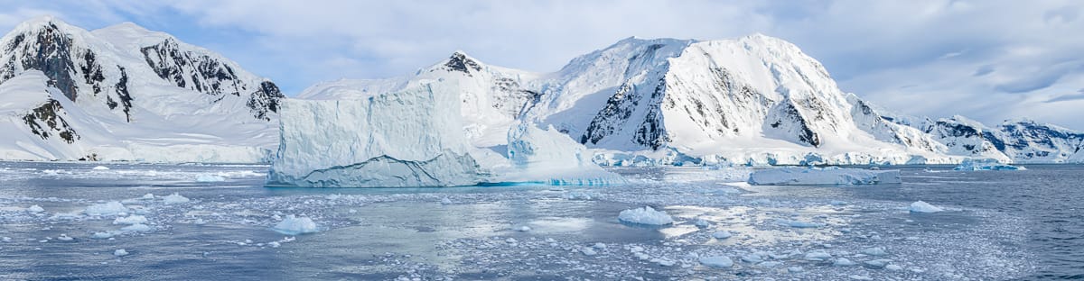
The trail climbed up from the carpark, and we were soon passing Diamond Lake, of which we had excellent views a little further along the trail. Looking from above, the dark waters of the lake were very picturesque.
Max elevation: 776 m
Total climbing: 511 m
Total descent: -508 m
Average speed: 4.23 km/h
Total time: 03:15:15
All Trails had indicated that it was best to take the Eastern trail to Rocky Mountain, so we followed these directions. As the trail climbed, there were several outcrops for better views of Lake Wanaka, the Southern Alps and Mount Aspiring. It was truly panoramic.

Sue and Beth at Rocky Peak Summit
We eventually reached the summit, and after enjoying the views, we descended along the Western trail. This seemed more rocky with some scrambling required. The forest was beautiful, and before we knew it, we had reached Diamond Lake again. We took the nature trail around the edge of the lake and back to the carpark.
This was an excellent half-day walk with stunning views.
Amongst other photographically recorded observations during this walk, we were able to confirm sightings of each of the following species: Sweet-Brier (Rosa rubiginosa), Austral Bracken (Pteridium esculentum), Purple Foxglove (Digitalis purpurea)
Wild Adventures Facebook Group
Trip Post
Clickable icons on this world map will open the related trip report
A detailed, searchable trip list with links to reports, photo galleries
Information on Parks signage along the way
Welcome to Diamond Lake Conservation Area
Nau mai, haere mai, tauti mai
A Jewel in the Crown
Diamond Lake Conservation Area is part of a spectacular mass of rock shaped by glacial action. Native forest and shrubland nestled into bluff systems add an attractive component to the landscape. The lake itself is an impressive feature with its dramatic backdrop of high schist cliffs. The summit of Rocky Mountain (775m) provides excellent views over Lake Wanaka and its two largest islands, Mou Waho and Mou Tapu. From this vantage point to the west rise the peaks of Mount Aspiring National Park with the distinct shape of Mt Aspiring/Tititea dominating the sky line.
Diamond Lake Conservation Area (106ha) is administrated by the Department of Conservation for the public to enjoy.
Track Times from Carpark:
Diamond Lake Circuit Track return 45min – 2.5km
Diamond Lake Lookout return 1hr – 2km
Lake Wanaka Lookout return 2hr – 5km
Rocky Mountain Summit Track return 3hrs – 7km
Follow the 4WD track from the carpark, climbing to the lake where the circuit track is marked. Another track winds up to a lookout above Diamond Lake. Beyond here, there’s a choice of the Lake Wanaka Lookout, off to the right or to Rocky Mountain’s summit via a loop track.
A Gem in the Making
From early times the Waitaha people occupied land near this site and at other localities in the Wanaka district. Some time after the consolidation of Kai Tahu settlement in the Canterbury area there were incursions into Waitaha and Kati Mamoe strongholds further South. Kai Tahu attacked the local settlement of Parakarehu near Glendhu Bay with a consequence that the Waitaha community suffered a defeat and a number of deaths. The prospect of further attacks cast a serious doubt over their future security. Subsequently, the survivors moved away to safer locations elsewhere with other kin groups. These events here and elsewhere saw the mana ki te whenua (authority over the land) gradually passing to Kai Tahu by the early 1800’s who then assumed a political ascendancy. However, many Southern communities continued to reflect a strong Waitaha and Kati Mamoe influence. This area was a gateway to the West Coast via both Tiori Patea (Haast Pass)and the Matakitaki Valley. Nehenehe, which was the pa site was occupied for the purposes of food gathering and gardening.
When the first Europeans arrived in the region in 1853 there were no Maori occupying the area. In 1859, a large Wanaka farming station was established by John Roy. This was subdivided into smaller runs in the 1880s and in 1897 Glendhu Station was formed. The Diamond Lake Conservation Area was formally created from this property in 2005.
Native Treasures
Native birds including fantail/piwakawaka, grey warbler/rioriro and bellbird/korimako dart amongst the bluff forest. The wide open skies host pipit/phoihoi and New Zealand falcon/kăreărea, which are known to nest nearby. The native bush, predominantly confined to the gullies and under higher bluffs, is broadleaf/käpuka, kohuhu, wineberry/makomako and the occasional black pine/matai. Marble leaf, tree fuchsia/kotukutuku and the occasional köwhai are other species that flourish within these forest remnants. Raupó, a wetland reed, forms a continuous band at the edge of Diamond Lake.
The local landscape features, geology, scenic highlights, flora, fauna, Indigenous history, white history and other nearby walks in the area (Perplexity AI Model)
The Diamond Lake and Rocky Mountain Track is situated within the Diamond Lake Conservation Area on the western shore of Lake Wānaka, in the Queenstown Lakes District of Otago, South Island, New Zealand. The loop traverses approximately 7.77 kilometres and ascends from the Diamond Lake Car Park at roughly 324 metres elevation on the Wānaka–Mt Aspiring Road to the summit of Rocky Mountain at 775 metres, before descending to the same trailhead. The track incorporates four designated sub-routes: the Diamond Lake Loop Track, the Lower Circuit Track, the Lake Wānaka Lookout Track, and the Rocky Mountain Track.
Landscape and Geomorphology
The broader landscape of the upper Lake Wānaka basin reflects the profound geomorphic legacy of Pleistocene glaciation. During the Last Glacial Maximum, large valley glaciers occupied the Clutha River system and its tributaries, excavating deep U-shaped troughs and overdeepened basins. The retreat of these ice masses — largely complete by approximately 14,000 years ago — left Lake Wānaka occupying a glacially carved depression approximately 300 metres above sea level. The lake covers roughly 198 square kilometres, reaches depths exceeding 300 metres, and is flanked by steep, glacially trimmed hillslopes. Diamond Lake itself occupies a smaller elevated basin at approximately 391 metres, likely a cirque remnant or ice-scoured hollow. Rocky Mountain rises to 775 metres and affords commanding views over Lake Wānaka, its islands, Glendhu Bay, and The Peninsula, as well as the distant ranges of the Southern Alps / Kā Tiritiri o te Moana to the west, including Mount Aspiring / Tititea at 3,033 metres — the southernmost of New Zealand’s mountains exceeding 3,000 metres.
Geology
The dominant bedrock throughout the conservation area is Haast Schist, a metamorphic rock belonging to the Otago Schist group. This schist formed from the metamorphism of greywacke and argillite protoliths under elevated pressures and temperatures during the Mesozoic era, producing the characteristic foliation, cleaved layering, and fractured bluffs that are conspicuous along much of the track. The schist outcrops, particularly the prominent bluff faces that also serve as a sport climbing area, display the well-developed schistosity typical of the Otago metamorphic belt. Of additional geological note, research in the Lake Wānaka region has identified an exceptionally ancient peridotite sample dated at approximately 2.7 billion years, representing some of the oldest mantle material recovered in New Zealand and attesting to the complex crustal history of the region.
Scenic Highlights
The track offers a graduated sequence of scenic experiences. The lower loop passes directly beside Diamond Lake, a small tarn fringed by raupo (Typha orientalis) and willows, whose still surface reflects the surrounding beech forest. The Lake Wānaka Lookout, equipped with a viewing deck and benches, provides a mid-elevation panorama across the expanse of Lake Wānaka, with the islands of Mou Waho, Mou Tapu, Te Peka Karara, and Ruby Island clearly visible. The Diamond Lake Bird View, a secondary vantage point above Diamond Lake, offers a contrasting aerial perspective of the tarn below. The summit of Rocky Mountain delivers unrestricted 360-degree views encompassing Lake Wānaka, the Glendhu Bay embayment, The Peninsula, and, to the west, the Southern Alps including the pyramidal profile of Mount Aspiring / Tititea.
Flora
Vegetation along the track reflects a transition from lower montane forest through subalpine shrubland to open tussock grassland on the upper slopes. The lower and middle sections of the track pass through mixed beech forest dominated by silver beech (Nothofagus menziesii) and mountain beech (Nothofagus solandri), with an understory of mosses, filmy ferns, and lichens characteristic of high-humidity beech forest microhabitats. Kōtukutuku (Fuchsia excorticata), with its distinctive papery copper bark, is present within the forested zone. As the track gains elevation, forest gives way to subalpine shrubland comprising mountain flax (Phormium cookianum), snow tōtara (Podocarpus nivalis), dracophyllum, coprosma, and mountain daisy (Celmisia spp.). The upper slopes support open tussock grassland communities, characteristic of subalpine environments across central Otago.
Fauna
The conservation area supports a diverse native fauna, although introduced predators — including stoats and rats — continue to exert pressure on bird populations despite ongoing predator control efforts. Native birds regularly observed along the track include kererū (Hemiphaga novaeseelandiae), tūī (Prosthemadera novaeseelandiae), bellbird / korimako (Anthornis melanura), fantail / pīwakawaka (Rhipidura fuliginosa), and tomtit / miromiro (Petroica macrocephala). Kea (Nestor notabilis), the endemic alpine parrot, may be encountered at higher elevations. Rocky and talus habitats are suitable for mountain stone wētā (Hemideina maori), and Southern Alps geckos have been recorded in the region. Lake Wānaka itself supports native freshwater species including kōaro (Galaxias brevipinnis) and kākahi (freshwater mussels), which have cultural significance to Ngāi Tahu as mahinga kai species. Introduced mammals, including rabbit, hare, and red deer, are present in surrounding areas.
Indigenous History
The Diamond Lake Conservation Area lies within the takiwā (tribal territory) of Ngāi Tahu (South Island dialectal form: Kāi Tahu), the principal Māori iwi of the South Island of New Zealand, and more specifically within the Kāi Tahu ki Otago country. The ancestral peoples Waitaha and Kāti Māmoe preceded and were absorbed into the Kāi Tahu confederation over successive generations. In Māori oral tradition, the interior lakes of the South Island — including Lake Wānaka — were formed by the ancestor Rākaihautū of the Waitaha people, who is said to have excavated them using his kō (digging stick), Tu Whakaroria, also known as Tuhiraki. The name Wānaka (also recorded as Oanaka) is attributed variously to the concept of wānanga (sacred knowledge or a place of learning) or to the chief Anaka/Anake. The lake shores were the sites of named Māori settlements, including Nehenehe at the Matukituki River mouth and the pā known as Take Kārara at what is now Roys Bay. The area was central to seasonal mahinga kai activities — including the harvesting of kōaro and tuna (eels), the hunting of kererū, kākāpō, and tūī, and the gathering of plant resources. The island Mou Tapu (meaning “sacred or forbidden island”) in Lake Wānaka was used for burial purposes, reflecting the profound cultural and spiritual associations embedded in the landscape. The region also served as a route for pounamu (greenstone) expeditions across Haast Pass to the West Coast.
European History
European engagement with the Lake Wānaka district commenced in 1853 when Nathaniel Chalmers became the first European to reach the lake, guided by the Māori chief Reko. Julius von Haast conducted explorations of the Southern Alps in the early 1860s, naming Haast Pass in recognition of the Māori-guided route across the Main Divide. Permanent European settlement of the upper Clutha Valley began in the late 1850s, driven primarily by the establishment of large merino sheep stations. Henry Norman is regarded as the first permanent European settler in the district, arriving in 1859–60. The town of Wānaka was originally surveyed in 1863 under the name “Pembroke”, honouring a British Colonial Secretary of the period; it was formally renamed Wānaka in 1940. Pastoral farming, gold prospecting (which began in 1861), and timber milling were the principal economic activities of early European settlement. The world’s first recorded sheepdog trials were held at Wānaka in 1867, a distinction that reflects the centrality of pastoralism to colonial settlement of the district. Diamond Lake itself features in local oral history as a venue for ice skating during severe winters of the 1950s, illustrating the informal recreational use of the conservation area by European settlers and their descendants prior to formal conservation designation.
Clickable icons on this world map will open the related trip report
A detailed, searchable trip list with links to reports, photo galleries
![]()