
Wednesday 11/10/2023 Mount Abrupt Carpark – Mount Abrupt Walking Track – Signal Peak Walking Track – Signal Peak – Mount Abrupt (825m) – Mud-Dadjug Hike-in Campground – C216
Grampians National Park, VICTORIA
Gariwerd Country
Participants: Stephen Davies (Photos, Report), Sue Davies
We departed the carpark at 9:00am, keen for the earlier start as a day reaching the high twenties was forecast. This walk commences climbing immediately from the trailhead and as we found yesterday, passes through a lot of different ecosystems in one day. These often came and went over short distances but the changes were much more noticeable than in many other places we have hiked. The tracks today were not new as they were for The Piccaninny and Mount Sturgeon sections yesterday but these are still high-quality tracks with many sections of steps formed from large flat boulders which have been positioned to make staircases on steeper sections.
Max elevation: 812 m
Total climbing: 1368 m
Total descent: -1372 m
Average speed: 3.15 km/h
Total time: 05:58:15
We were barely beginning before I noticed what I first thought to be a 20cm length of bright yellow cord sidetrack, however, on closer inspection, it turned out to be a remarkable little Canary Worm (Fletchamia sugdeni). Again there were copious numbers of plants in full bloom, mostly whitish flowers on larger bushes but with a sprinkling of much smaller plants sporting blues, reds and orange flowers. The track itself was far less formed than the new tracks around Mount Sturgeon we had walked yesterday.
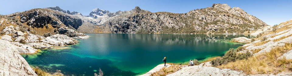
After climbing for a while we reached a small cliff line, which the track follows towards the north before heading across a wide saddle towards the base of Signal Peak. The first of many stone staircases now led us up onto Signal Peak’s slopes which are then followed around and upwards towards the summit. Here we met a solo walker who had started 10 days ago at the northern end of the park. He was now looking very fatigued but determined to finish today, just to be done with the walking. Along the way, there are some fantastic views back towards Mount Abrupt to the south and out over the open plains to the west. After about 30 minutes of walking, views of the rest of the Grampians to the north came into view.

Signal Peak from near Mount Abrupt
With the temperature rising to 28C during the day, we were pleased that there was some breeze around. More stairs led to the summit of Signal Peak and there the wind was getting quite strong. The views are fantastic in all directions.
Returning along the track we caught all the views from the opposite direction and on reaching the track junction near a small cliff we continued south along the Mount Abrupt Walking Track. As we climbed we got plenty of great views back to Signal Peak and glimpses of the summit of Mount Abrupt. Further along the Signal Peak views were enhanced by the backdrop of the northern Grampians, all whilst continuing to be spoilt with the showcase of wildflowers. The cliff edge just to the east of the track provides some beautifully sculptured, lichen-covered rock formations, most notably a trackside, tongue-like projection well suited for an Instagram selfie.
The wind again was strongest at the summit. It is capped with a steel trigonometric (trig) station, and after taking in the fantastic views we dropped off the top just a little, finding shelter amongst the trees and rocks for a lunch break. The panoramic views from the summit are brilliant, taking in Signal Peak and the rest of the northern Grampians. To the south, we could see yesterday’s destinations of The Piccaninny and Mount Sturgeon. To the east, a patchwork of green fields and roads dotted with many isolated trees and in the distance several wind farms. To the west green farmland with several lakes with more “mountains” (the western section of The Grampians) not far beyond.
Our descent from the summit took us down and around to the eastern side of Mount Abrupt. Along the way seeing more and more of the cliffs of this side. We “side-tracked” around to Mud-Dadjug Hike-in Campground, which has fantastic facilities including many elevated tent platforms with easily adjustable chain-link tent anchor points. The cooking shelter is large and fully enclosed, to our surprise including USB recharging facilities. Sitting on the deck in the shade, out of the sun was a solo female multi-day walker who was chilling reading a book before her planned finish tomorrow.
As we had been informed by staff at the Dunkeld Visitor Information Centre, there is a rough track down along the gully past the campsite which leads to the road. The track commences just past the water tank from where it descends steeply down the gully, which quickly dominates your presence. This unformed track is easily followed but nothing like what we had walking the rest of the day. Again during our descent, we were impressed with the scenery. As we exited the gully there were a couple of very colourful “caves” above and on the slopes below there were plenty of changes in the dominant species. Grass Trees (Xanthorrhoea australis) in one spot, reeds nearby and a variety of tree species and grasses as it opened up a little on the lower slopes.
Now back onto C216, we headed along the bitumen for the last couple of kilometres to our vehicle. We had met a dozen or more fellow hikers along the way, one couple in four different locations, so we were never truly alone. The temperature got into the high twenties during the afternoon but we never felt hot as there always seemed to be enough breeze or wind to keep it comfortable. With rain forecast for tomorrow, we were very pleased to have now got in two-day walks from our base in Dunkeld.
Information on Victorian National Parks signage along the way
Moving Mountains – Mt Abrupt Landslip
A wet summer
Significant rain during the months of September and December 2010 caused widespread flood damage throughout the Grampians National Park. In January 2011, 297mm of additional rain fell on the Grampians in just two days.
This resulted in major flooding and caused hundreds of landslips throughout the National Park. Bridges were washed away, visitor sites were significantly damaged and fallen trees and enormous boulders blocked roads and walking tracks to many areas of the park; the landscape and some sites have been changed forever.
Nature’s handiwork
When park rangers arrived at Mount Abrupt to assess the damage from these storms, they found numerous debris flows (landslips) originating from the mountain’s peak. Heavy rainfall onto the steep slopes of Mt Abrupt had caused saturated soils to suddenly move down slope.
Following the path of least resistance, tonnes of water, rocks, soil and trees crashed rapidly down steep gullies, obliterating everything in their path. Many sections of the popular Mt Abrupt walking track were completely washed away.
A sustainability challenge
Restoring access to Mt Abrupt has been an enormous task for Parks Victoria. Many sections of the walking track have been repaired or realigned. In this time of climate change, where events like these are likely to occur more regularly, creating sustainable park facilities is a priority for park managers.
It is hoped the re-built Mt Abrupt walking track will provide safe and sustainable access for park visitors well into the future.
At Mud-Dadjug Hike-in Campground
The Grampians National Park is part of the Greater Gariwerd cultural landscape, in the traditional Country of the Jadawadjali and Djab Wurrung People. Represented by Barengi Gadjin Land Council, Eastern Maar Aboriginal Corporation and Gunditj Mirring Traditional Owners Aboriginal Corporation, Traditional Owners have a deep and continuing connection to the lands and waters of this landscape, and Parks Victoria recognises their ongoing role in caring for Country.
Grampians Peaks Trail Sections
Mud-Dadjug to Dunkeld Grade 4 Distance: 14.7km, 5 to 5.5 hours
A grassy, rocky hill-like summit (422m) with views to the east.
Names/meanings: Mud-Dadjug = Murd-dajook: blunt, useless arm.
Highlights: Bainggug (The Piccaninny) and Mt Sturgeon (Wurgarri) (582m). Bainggug is renowned for its winter and spring native wildflowers including spider, tiger, waxlip and greenhood orchids.
Descend steeply passing a reservoir and then climbing over Bainggug (the Piccaninny). Cross Victoria Valley Road and undertake the final climb over Mt Sturgeon (Wurgarri). Take in stunning views out over volcanic plains and the impressive peaks of the southern Grampians. To the north are the sedimentary sandstones of Gariwerd; to the south, basalt lava flows.
Complete your journey by steeply descending into farmland below and wandering through open old-growth Red Gum woodland to arrive at Dunkeld for a hot shower, great meal and comfortable bed. Congratulations!From Grampians National Park Visitor Guide
Mud-Dadjug to Djardji-djawara Grade 4 Distance: 7.9km, 3.5 to 4 hours
Section hazards: The high summits of Signal Peak and Mt Abrupt are exposed. They can be very cold, wet and windy in any season. Hikers should be well prepared for these conditions.
Names/meanings: Djardji-djawara = ‘Djatji-djawara’: Djadki = sister. Mud-Dadjug = ‘Murd-dajook”: blunt, useless arm.
Highlights: New sections of trail passing through stunted eucalypt forest, the rocky mountain summits of Signal Peak and Mt Abrupt (Mud-Dadjug).
Leave Mud-Dadjug Hike-in Campground climbing steep rock steps to Mt Abrupt (Mud-Dadjug), an exposed rocky summit marked by a steel trigonometric (trig) station.
Descend from Mt Abrupt down rock steps and slabs into forest and the track junction to Mt Abrupt Carpark.
Continue north climbing to Signal Peak and then descend rock steps and jumbles of boulders passing small cliffs and ledges that provide excellent vantage points. Cross Cassidy Gap Road, hike uphill and shortly reach Djardji-djawara.
Information on a Parks Victoria Information Booklet
Environment, culture and heritage
Aboriginal cultural heritage
The park, traditionally known as Gariwerd, has an Aboriginal cultural history dating back at least 22,000 years. The landscape holds this heritage and protects many important cultural sites, including the largest collection of rock art in south-eastern Australia.
Begin your cultural journey at Brambuk, or visit one of five easy to access rock art shelters open to the public; Ngamadjidj, Gulgurn Manja, Billimina, Manja and Bunjils (Black Range Scenic Reserve near Stawell).
Post settlement history
The Grampians was named after the Grampian Mountains in Scotland by Major Thomas Mitchell on his 1836 expedition. Since this time the area has seen much change through resource industries such as forestry, stone quarrying, gold mining and water harvesting. People have been drawn here for thousands of years and tourism established its roots in the early 1900s. More than 1.3 million people from all over the world visit the park annually.
Geology
The four distinct sandstone ranges of the Grampians began forming approximately 430 million years ago. Over time, geological processes such as pressure, heat, folding, faulting and erosion have slowly shaped the mountains we see today. Geology is fundamental to soil composition and influences where flora found here.
Plants
The park protects one third of Victoria’s flora species and is the most important botanical reserve in the state. Close to 970 native species occur and over 40 are found nowhere else in the world. The area is known for its colourful spring wildflower displays and popular walks include Heatherlie area, Sundial Peak, The Piccaninny and Mt Zero.
Wildlife
The park provides habitat for at least 230 bird, 40 mammal, 30 reptile, 11 amphibian and 6 native fish species. There are 50 known species in the park classified as threatened, including Brush-tailed Rock Wallabies, Smokey Mice and Powerful Owls. Halls Gap and Fyans Valley are one area to see Eastern-grey Kangaroos, Emus and to hear kookaburras. Usually at dawn and dusk.
The local flora, fauna, geology and history (Bard)
Flora
Grampians National Park, also known by its Aboriginal name Gariwerd, is a national park located in the Grampians mountain range in western Victoria, Australia. The park is home to a diverse range of flora, including over 900 species of vascular plants.
The park’s forests are dominated by eucalypts, such as the river red gum (Eucalyptus camaldulensis), swamp gum (Eucalyptus ovata), and manna gum (Eucalyptus viminalis). Other common trees include the black wattle (Acacia mearnsii), silver banksia (Banksia marginata), and mountain ash (Eucalyptus regnans).
The park’s understorey is home to a variety of shrubs, herbs, and grasses. Some of the most common shrubs include the wattleseed (Acacia acuminata), hop bush (Dodonaea viscosa), and prickly bush-pea (Pultenaea scabra). Common herbs include the kangaroo apple (Solanum aviculare), billy buttons (Craspedia chrysantha), and blue leschenaultia (Leschenaultia biloba).
The park’s flora is adapted to the region’s Mediterranean climate, with hot, dry summers and mild, wet winters. Many of the plants are drought-tolerant and have deep roots to reach water stored in the soil. Others are fire-tolerant and have mechanisms to regenerate quickly after fires.
Fauna
Grampians National Park is home to a variety of fauna, including over 200 species of birds, 60 species of mammals, and 40 species of reptiles.
Some of the most common birds in the park include the laughing kookaburra (Dacelo novaeguineae), kookaburra, eastern grey kangaroo (Macropus giganteus), and common wombat (Vombatus ursinus). Other notable species include the emu (Dromaius novaehollandiae), wedge-tailed eagle (Aquila audax), and peregrine falcon (Falco peregrinus).
Some of the most common mammals in the park include the echidna (Tachyglossus aculeatus), platypus (Ornithorhynchus anatinus), common brushtail possum (Trichosurus vulpecula), and sugar glider (Petaurus breviceps). Other notable species include the koala (Phascolarctos cinereus), rock-wallaby (Petrogale assimilis), and dingo (Canis dingo).
Some of the most common reptiles in the park include the eastern brown snake (Pseudonaja textilis), tiger snake (Notechis scutatus), and red-bellied black snake (Pseudechis porphyriacus). Other notable species include the bearded dragon (Pogona barbata), goanna (Varanus giganteus), and tortoise (Chelodina longicollis).
Geology
Grampians National Park is located in the Grampians mountain range, which is made up of sandstone and quartzite rock. The rock was formed over 400 million years ago, when the region was part of a vast ocean. Over time, the ocean receded and the land was uplifted, forming the mountains.
The sandstone and quartzite rocks of the Grampians are resistant to erosion, which is why the mountains have remained relatively unchanged for millions of years. However, the rocks have been weathered and eroded over time, forming the park’s distinctive rock formations, such as The Pinnacle and The Balconies.
Indigenous History
The Grampians National Park is the traditional home of the Djab Wurrung and Jardwadjali people. These Aboriginal groups have lived in the region for over 22,000 years.
The Djab Wurrung and Jardwadjali people have a deep spiritual connection to the land of Gariwerd. The park’s many rock art sites are testament to the long and rich history of Aboriginal culture in the region.
The Djab Wurrung and Jardwadjali people were forcibly removed from Gariwerd in the 19th century. However, they have maintained their connection to the land and continue to fight for its protection.
White History
The first Europeans to visit the Grampians were explorers Hamilton Hume and William Hovell in 1824. The first settlement in the region was established in 1836.
In the early years of European settlement, the Grampians were used for grazing sheep and cattle. However, the region’s sandstone and quartzite soils are not well-suited for agriculture. As a result, the Grampians became a popular destination for recreation and tourism.
In 1984, the Grampians National Park was established to protect the region’s natural environment.
Clickable icons on this world map will open the related trip report
A detailed, searchable trip list with links to reports, photo galleries and other content
![]()