
10/8/2016 – 16/8/2016 Dead Horse Gap to Mount Kosciuszko return, Rams Heads and Horse Flat area
Kosciuszko National Park
Ngarigo country
Distance: 75km Total Ascent: 4770m Total Descent: 4770m
Time: 42 hours Track Info
Participants: Damien Aggio (Leader), George Copeland (3 days), Stephen Davies (Report, Photos), Michael Mieczkowski (4 days)
Day 1: Wednesday 10/8/2016 Dead Horse Gap – Camp
Max elevation: 1849 m
Total climbing: 227 m
Total descent: -35 m
Average speed: 2.35 km/h
Total time: 00:40:22
Damien had arrived around 9:30am to commence our trip south. With a newly purchased National Parks pass, we took his car.
After lunch by Lake George, a stop in Jindabyne to pick up my repaired and waxed ski and lots of catching up along the way we were parking at Dead Horse Gap with just enough time to climb up to camp before sunset.
The very firm but full snow cover had us climbing well with lighter than normal packs, as we planned to return to the carpark next morning to meet up with Michael. We arrived at camp to join George who had come up earlier in the day. Our tents went up just as it was getting dark. As there was a cold gusty breeze we each quickly retired to our tents to prepare dinner. This proved a much longer chore than usual as the gas stove could only produce a small, weak flame due to the low temperature of the gas. It took about 15 minutes to boil the billy.
A lot of flapping tent fabric, the sound of snow hitting the tent and wind noise “outside” made it a little hard to settle for the night.
Day 2: Thursday 11/8/2016 Local runs around camp
Max elevation: 1883 m
Total climbing: 811 m
Total descent: -829 m
Average speed: 5.23 km/h
Total time: 06:02:57
We awoke to blue sky and a cool breeze and were delighted to find a centimetre or two of fresh snow on top of the existing hard base. The three of us headed back down to the cars and our meeting with Michael a little after 8:30am. It proved to be one of the best ever runs back down with the thin layer of fresh snow atop a firm base giving great glide and slide. We had lots of great turns through the trees, one just needed to take care to avoid the frozen remains of the old tracks often hidden just below the snow surface.
Michael was waiting for us as planned, so after Damien and I packed our second load we were off up the hill again.
After a morning tea break Michael remained in camp setting up whilst the rest of us headed up towards the tree-line for some fun. Here the wind had done it’s work, exposing some of the hard icy layer beneath so we all tried to pick our spots to turn on the run back down. Looking for more consistent cover our next run was down the creek from our previous take off point. I got lucky in staying out of and above the creek as staying close proved a little more awkward than anticipated.
My fourth use of my new kicker skins resulted in their failure, as in my first attempt to take them off by pulling on the locking strap whilst leaving my skis on, I managed to pull the skin off at the connecting rivet.
The other three now did a run right down along the creek until they reached the road whilst I made another trip to the car to drop off my damaged skins and collected my old ones. Definitely a much easier return climb without the weight of a loaded backpack.
The afternoon proved very frustrating as a medical condition dictates that I restrict my heart rate and my monitoring watch was producing wildly inaccurate readings (verified by manually measurements). So with a cold gusty wind blowing, my companions completed a few runs down the creek and with some failed high tech, I opted for the warmth of the tent.
Day 3: Friday 12/8/2016 Local runs around camp
Max elevation: 1912 m
Total climbing: 489 m
Total descent: -492 m
Average speed: 3.49 km/h
Total time: 06:53:06
The weather looked a lot more promising this morning so we thought we might try for a Mount Kosciuszko tour. However, the continued erratic heart rate values being displayed by my heart rate monitoring gear had me back in my tent replacing the chest strap battery.

Camped below South Rams Head
The “solution” didn’t last long and neither did I. Medical advice limits my physical exertions to 150bpm and after a couple of years monitoring my physical activity with my Garmin watch was now displaying values way out of proportion to my early exertions. Feeling OK but none-the-less checking my pulse manually revealed an unusually high pulse. At this stage, I pulled out my ECG device only to find a nonsense result. Cross checking by using it on Damien produced the same anomalous result. So as the other three headed off to ski, I returned to my tent to try my old ECG (brought as a backup). To my dismay it didn’t even register.
After warming myself and my devices up for a hour normal results were finally being displayed.
So after a quick lunch I was back on the snow to do a bit more testing. A couple of hours on a nearby very gentle slope, one of the few nearby where the fresh cover hadn’t yet been blown off, revealed my technology was performing badly when cold, but I wasn’t doing any better with continued higher than normal heart rate.
The other three hadn’t gone very far anyway, as the clouds had returned and visibility had become very limited, and there was way too much exposed ice around. Damien and George had headed off for a creek run whilst Michael returned to camp.
The afternoon saw Michael join me for a while whilst Damien and George followed the creek down to the road again. George then packed up his gear and headed back to his car with Damien accompanying him for a few extra turns. This was proving an exceptionally good run as more snow remained amongst the shelter of the trees.
Again the evening was too cold and windy to linger outside so we all retired to our own tents for dinner and some reading.
Day 4: Saturday 13/8/2016 Local runs around camp
Max elevation: 1808 m
Total climbing: 764 m
Total descent: -776 m
Average speed: 5.03 km/h
Total time: 06:29:26
It was still cold and windy with lots of low cloud about. After a few more runs on the baby slope above our campsite I still wasn’t too happy with my physical condition.
So after an early lunch I was back to the same spot again but with a distinct improvement in my bodies response to exertion. A much better afternoon ensued with more runs heading further down the creek. So after a day and a half of self imposed restrictions to limit activities to hills not requiring skins out, they came again.
Around 4:00pm Damien and I headed part the way down towards the carpark until the trees became a little too numerous and close together before returning to camp. Damien couldn’t resist and headed off for a repeat run, not returning to camp until just before dark.

Camp below South Rams Head
We ran into a lot of other parties today and gained some new neighbours, a group of six who had a large stand up tent and dedicated toilet shelter camped on the creek about 50m away.
Day 5: Sunday 14/8/2016 Thredbo ridge return
Max elevation: 1886 m
Total climbing: 541 m
Total descent: -524 m
Average speed: 3.80 km/h
Total time: 07:01:16
Awoke to a fantastic day – perfectly still with blue sky as far as the eyes could see. However, as there had not been any fresh snow falls for some time, the snow itself was very firm with only a few remnants of wind blown deposits.
Looking at something a little different we sidled our way around towards Thredbo, carefully negotiating our way through the snowgums, rocks and small creeks. Here, Michael struggled at times as his previous experiences had been on flatter terrain. A previous broken ankle from skiing helped explain his caution.

Looking across upper Bogong Creek
After having lunch on high rocks on Thredbo Ridge we made our way down along the ridge. We encountered connected twin igloos and a couple of other groups who were chasing an Off Piste experience away from their resort.
After crossing the footbridge near the road we put our skins onto our skis and climbed straight back up to our campsite.
A glorious clear dry night followed under a waxing moon, which I recorded in a time-lapse from camp.
Day 6: Monday 15/8/2016 Camp – Mount Kosciuszko return
Max elevation: 2245 m
Total climbing: 900 m
Total descent: -886 m
Average speed: 6.06 km/h
Total time: 06:16:54
A repeat of yesterdays weather – endless crystal clear blue sky.
Michael was out of time so was packing up to leave. Damien and I decided a tour to Mount Kosciuszko was in order.
A late 10:00am start saw us climbing towards the Rams Heads across hard, old, very solid ice and snow. We were surprised to find a noticeable improvement in snow conditions the further we progressed not withstanding the harder surfaces across the windblown passes.
A quick, rattling sidle on our edges saw us into the Cootapatamba Valley along which there was good firm packed snow. After a pleasant climb up the valley, along with outstanding views in perfect seeing conditions we had some lunch before our final ascent.

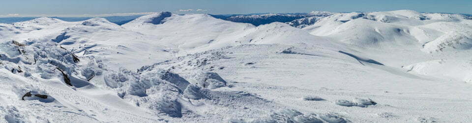
Swampy Plain River to Bogong High Plains
Two snowboarders, and a guide with his MS suffering client were already there. The perfectly clear seeing conditions saw lots of photos taken (duplicates of duplicates of previous trips)!
An excellent downhill run saw us deep back down into the Cootapatamba Valley in short time before an uphill sidle to get us back on top of the Rams Head range. From here we skirted a bit wider than usual to take in some new scenery before returning to our standard route. From our final high point we knew our last run would consist of lots of ice, breakable crust, pockets of firm old snow, rocks and the occasional grassy patch – not the setting for an enjoyable telemark run. So as a alternative I decided to explore the return descent with great caution and look out carefully for new photo opportunities. Damien in the meantime headed off to summit South Rams Head.
I arrived back in camp at 4:30pm with Damien getting in not long after. Easily our best day of this trip.
Day 7: Tuesday 16/8/2016 Camp – South Rams Head – Horse Flat return to Dead Horse Gap
Max elevation: 2062 m
Total climbing: 1052 m
Total descent: -1208 m
Average speed: 5.61 km/h
Total time: 05:12:08
A bit of cloud had returned by morning as we headed up onto the top of the range to look for some good runs. It turned out to be pretty unpleasant considering the cold wind and majority very solid cover, so after quickly admiring the views to the south and west we sidled across snowdrifts to the trees beneath South Rams Head. From here we headed back to camp along the ridge beside the creek and through the trees. We had a much better run here than the much icier direct path we had taken up.
A quick lunch and packing up of camp had us heading back to the car through the trees on a softening surface.
After stowing our gear in the car we followed Damien’s suggestion for an afternoon exploration on the ridge heading east of Dead Horse Gap which includes Horse Flat.

Views from around Horse Flat
Viewed from our campsite there was no snow through valley but higher up in the trees around Horse Flat it looked more promising. After walking a couple of hundred metres we had our skis on, not to be taken off for the next couple of hours. Our afternoon sojourn had us catch good views back to the Rams Heads and south into Victoria and the Pilot. A number of potential campsites were observed for future trips. The afternoon snow was much softer and easier going than that of the slightly higher altitudes, amazing what a difference a couple of hundred metres in elevation makes. A surprisingly interesting area with lots of potential for future trips a little removed from the cold, windy treeless ranges just above.
Clickable icons on a world map which open the related trip report
A detailed, searchable trip list with links to reports, photo galleries and other content
![]()