
23/05/2026 – 25/05/2026 Cascade Trailhead – Cascade Trail – Thredbo River – Bobs Ridge – Cascade Creek – Cascade Hut – Cascade Creek – Bobs Ridge – Thredbo River – Teddys Hut – Thredbo River – Cascade Trailhead
Kosciuszko National Park, NSW
Ngarigo Country (Ngarigo people)
Distance: 35.1km Total Ascent: 1765m Total Descent: 1765m
Time: 15 hours
Participant: Stephen Davies (Report, Photos)
With winter and my 70th birthday fast approaching, I wanted to get out for an overnight walk. This would also give me the chance to field test some new gear.
My wife Sue and I drove down to base ourselves at our daughter’s place in Jindabyne. Christianing our brand new Kia EV3 Air Long Range to do so. It is awesome to drive. Despite having the range to do Wollongong to Jindabyne, we stopped in Cooma to try out the fast charging. After failing to get the NRMA system to work on our vehicle, we moved on and had success at the 10 bay Tesla charging station.
Day 1: Saturday 23/05/2026 Cascade Trailhead – Thredbo River – Bobs Ridge – Cascade Creek – Cascade Hut (built 1935)
Kosciuszko National Park, NSW
Ngarigo Country (Ngarigo people)
After spending Friday night at Jindabyne, this morning I found myself heading off alone. Sue had planned on joining me on the hike, however, she got cold feet when she saw the forecast overnight low temperatures.
After parking at Cascade Trailhead, I headed off, laden with a bit too much gear. Part of my aim was to test where my fitness and knee rehab were up to and try a few things out. A tripod and an extra lens were also on board.
Max elevation: 1790 m
Total climbing: 555 m
Total descent: -617 m
Average speed: 3.56 km/h
Total time: 04:14:20
I was so grateful to be out on track and really enjoyed just being present in the moment. The weather was slightly overcast but calm and mild.
Not too far in, I began to despair. The hike over Bobs Ridge had become very painful, as the arthritic knees were having a moment. My lunch stop at Cascade Creek brought temporary relief, the knees being good if I didn’t walk on them.

View south from Cascade Trail on Bobs Ridge
Being the weekend, there were plenty of people about, mostly day trippers on mountain bikes and a few walkers also out for the day, but no one else was overnighting.
I arrived at Cascade Hut around 4:00pm, putting up my tent right next to the hut. As the shadows lengthened, I set up the tripod and camera for a time-lapse, hoping the clouds might thin enough to get a star trail or two. I was disappointed when I retrieved the gear around 9:00pm, as the lens was covered in a layer of dew. This sequence will definitely come with a soft focus look.
The night was magic, as it remained perfectly calm, and the incredible silence of the night was amazing.
Cascade Hut Logbook 4/5/2024 – 24/5/2026
Day 2: Sunday 24/05/2026 Cascade Hut – Cascade Creek – Bobs Ridge – Thredbo River – Teddys Hut (built 1948) – Teddys Creek
Kosciuszko National Park, NSW
Ngarigo Country (Ngarigo people)
Max elevation: 1791 m
Total climbing: 871 m
Total descent: -624 m
Average speed: 3.32 km/h
Total time: 06:20:57
This morning, I wasn’t in any hurry, so I was able to enjoy being in this beautiful spot by myself, along with a few birds who sang with joy as day broke.

Sunset over Cascade Creek below Cascade Hut
After breakfast, I watched a small mob of brumbies running along Cascade Creek. A couple of minutes later, a group of five mountain bikers briefly stopped by for a chat before heading off further afield. It seemed the Brumbies had been spooked by their intrusion.

Cascade Hut
I had found yesterday to be hard, so I was hoping for a better day today. To improve the odds, I took a couple of Panadol Osteo before walking. I also took my time with a slow, steady ascent to Bobs Ridge. The knees were now feeling way better than yesterday. Thank goodness for drugs, happy days! With 2 bars reception near the Bobs Ridge sign, I was able to check the upcoming weather forecast to help decide which way I would go after lunch.
Today had a thicker cloud cover than yesterday and it was still mild, except for a couple of short periods when there was a slight breeze about, and it felt much cooler.
Again, there were several groups of mountain bikers out for the day, along with a couple of dayhikers and two blokes doing Cascade Hut return as a morning trail run.
I stopped next to the Thredbo River crossing for lunch before committing to head to Teddys Hut for the night. I was finding it hard to believe how much better the old arthritic knees were today than yesterday, and I crossed my fingers that they would remain so.
From the footbridge, you get single-track for another couple of kilometres upstream before it disappears. From that point on, you do the best you can, trying to keep off spagnum moss, boggy areas and out of a multitude of small creeks. Wet feet are virtually guaranteed, as is very uneven footing. There are also plenty of holes to avoid, some knee deep, and multiple crossings of the Thredbo River as you work your way further upstream across the headwaters of the river. Along here, I sighted a pair of feral deer running below the treeline.
As I finally caught sight of Teddys Hut, it was already quite dark due to the heavy cloud cover. Now at my target destination, I quickly scouted the area before finding a flattish spot about 100m from the hut and began setting up camp for the night.
From the hut logbook, it can be clearly seen that Teddys Hut is far less frequented than Cascade Hut; Teddys Hut looks lucky to see one registered visit per month.
Now settled into camp for the night, the excitement and tension were quickly building for my 70th birthday tomorrow. I can’t think of a better way to start a significant new decade than being alone under the Milky Way in the Australian Wilderness to contemplate being.
Surprisingly, with 1 bar of 4G on Telstra at my selected campsite, I also got to make a couple of calls.
My Cascade Hut Logbook Entry
24/5/26 70ya. tomorrow, this is my birthday present to myself. Camped beside the hut. Mostly overcast but mild and very calm. Awesome as you can then hear how quiet it is! except for the birdsong. I was last here with Damien 23/4/25 SOBO on AAWT. Can report that we made it to Tharwa. Detailed report at ssdavies net includes food, food drop details, gear lists, etc]. Hope to wake up tomorrow near Teddys Hut (will not be taking any shortcuts) Loving the solitude. Stephen Davies.
Day 3: Monday 25/05/2026 Teddys Creek – Teddys Hut – Thredbo River – Cascade Trailhead
Kosciuszko National Park, NSW
Ngarigo Country (Ngarigo people)
The big day has arrived. I made it to 70!
As my father only made it to 48 and his father to 55, I feel very fortunate. I also feel blessed that I can still get out and do this.
Max elevation: 1732 m
Total climbing: 344 m
Total descent: -520 m
Average speed: 3.17 km/h
Total time: 04:08:43
When I stepped out of the tent late last night, it was still so heavily overcast I couldn’t detect the moon. Not the night for a timelapse. However, before sunrise, the sky was completely clear, bar a band of clouds low on the eastern horizon. There was a good frost cover over the tent, but inside the single-shell Durstan tent, it was still cosy overnight.

My campsite near Teddys Hut with Mount Terrible
As first sunlight appeared, I found myself a tree with a seat, a low, horizontal section of branch at seat height, with a small leafy branch strategically placed to keep the sun off my face. It was a brilliant spot to sit and soak up the warmth of the morning sun under a bluebird sky without a puff of breeze. Perfect way to start the day.
When the time came to get going again (after all, I needed to get to Jindy for some birthday celebrations with my family), I put wet boots and socks on, packed up and got moving by 9:30am after a very relaxing morning.
I felt my route selection was a little better heading back than coming in yesterday. I stuck more to the north side of the river this time and seemed to find and lose more “tracks” than yesterday. I did get caught out in one spot trying to get around a fallen limb at a “creeklet” crossing, edging around the obstacle, my left foot slipped into a concealed hole, only for my right foot to then find an even deeper one. Helplessly off balance, I was soon on the ground, tangled in the undergrowth. It involved a lot of effort and maneuvering to extricate myself, fortunately not injured, but I did find a large bruise developing on my forearm a couple of days later.

Sphagnum bog
Just the nature of the terrain across the headwaters of the Thredbo River makes the walking slow and potentially hazardous. Expect slipping, wet feet, boggy ground, sphagnum moss, deep concealed ditches and multiple river crossings. Good judgment and some luck are required to find a good route.
Once back on track with the ground underfoot a little firmer, lots of small grasshoppers were observed. Significantly and very sadly, during the three days, I saw only feral animals – a small mob of Brumbies and a pair of deer.
The only person I saw today was in a service vehicle heading up the track, not far from the trailhead. I arrived back at my vehicle about 1:30pm after a wonderful and slightly challenging three days out in fantastic walking weather.
My Teddys Hut Logbook Entry
25/5/26 Came around from Cascale Hut yesterday. Weather has been cool and overcast but calm making for very pleasant walking. The clouds became heavy and dark late yesterday but I awoke to my 70th birthday this morning to clear skies and calm. A magic morning to enjoy before heading back to Jindy and family to celebrate making it this far. The walk-in was boggier than I remembered. I much prefer it as a ski when the snow is there. Stephen Davies ssdavies.net
Amongst other photographically recorded observations during this walk, we were able to confirm sightings of each of the following species: brumbies (Equus caballus), feral deer, grasshoppers (Orthoptera spp.), sphagnum moss (Sphagnum spp.)
Teddys Hut Logbook 2/12/2006 – 26/8/2018, 10/12/2020 – 25/5/2026
The local landscape features, geology, scenic highlights, flora, fauna, Indigenous history, white history and other nearby walks in the area (Perplexity AI Model)
Landscape and geology
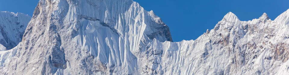
The three-day route from Cascade Trailhead to Cascade Hut, Teddys Hut and back follows a broad north–south corridor along the upper Thredbo River and its tributaries, framed by rounded ridges and open valley floors. The path traverses a mixture of gently sloping river terraces, more pronounced climbs over Bobs Ridge and undulating high valley ground near the river headwaters, producing a repeating pattern of ascent, plateau and descent. Geologically, this part of Kosciuszko National Park lies within the high country of the Snowy Mountains, underlain predominantly by granitic rocks that have weathered to produce coarse, often sandy soils and rounded, boulder-strewn slopes. The combination of resistant bedrock, periglacial processes and long-term fluvial erosion has created subdued hill forms, broad frost-hollow valleys and poorly drained flats that are particularly evident in the boggy headwaters of the Thredbo River.
Scenic highlights
Along the Cascade Trail the scenery alternates between enclosed forested spurs, where the trail threads between trees with only glimpses of the surrounding country, and more open sections where views extend across the Thredbo valley and towards the higher ranges of the Main Range and Pilot Wilderness. The crest of Bobs Ridge provides one of the more expansive viewpoints, with a clear sense of the transition from the immediate river corridor to the more distant high peaks and the layered ridges stepping away towards the south and west. Cascade Hut itself occupies a visually striking setting, sitting in a grassy clearing beside Cascade Creek, with open space to the north and east and wooded slopes enclosing the scene, while Teddys Hut lies in more subtle, gently rolling country, where the interest lies as much in the intimate pattern of creek lines, bogs and snowgums as in any single dramatic vista.
Local flora
The vegetation along the route reflects the altitudinal band and cold, moist climate of the Snowy Mountains, dominated by snowgum woodlands and subalpine shrublands on slopes and ridges, grading into sedge, grass and moss communities on the wetter flats and valley bottoms. On the Cascade Trail and over Bobs Ridge, the track passes through open forest and woodland where scattered trees and a relatively simple understorey allow long sight lines, while the ground layer consists of tussock grasses, low shrubs and patches of herbs adapted to seasonal snow cover and frost. In contrast, the headwaters of the Thredbo River near Teddys Hut are characterised by saturated soils, sphagnum bogs and intricate networks of small channels, supporting a specialised flora that traps and stores water and plays a key role in regulating downstream flow and water quality. Seasonal changes in leaf colour, flowering and ground cover are pronounced, with late autumn and early winter, as on this trip, emphasising structural elements such as trunks, branches and grass tussocks as foliage density declines.
Local fauna
The broader Thredbo–Cascade–Teddys area supports a fauna typical of the subalpine and alpine zones of the Australian Alps, including a range of birds, small mammals and ground-dwelling animals adapted to cold winters and short growing seasons. During the walk, feral horses (brumbies) and deer were observed in the valleys and along the edges of the treeline, reflecting the ongoing presence of introduced species that can significantly affect native vegetation, soils and waterlogged areas such as bogs. Birdlife was evident around the huts and along the river corridor, with calls and movement providing much of the soundscape in otherwise quiet conditions, and smaller ground fauna signalled by tracks, scat and subtle movement in the undergrowth rather than by direct, prolonged sightings. The relative openness of the woodland and the broad valley forms favour wide fields of view, which facilitates both wildlife observation and awareness of feral animal impacts on the landscape.
Indigenous history
Kosciuszko National Park, including the Cascade–Thredbo–Teddys area, lies within Ngarigo Country, and the Ngarigo people maintain deep cultural, spiritual and historical connections to this high country landscape. The Snowy Mountains have long been recognised as a focus for seasonal movement, ceremony and resource use by First Nations communities, particularly in relation to gatherings associated with seasonal food resources in the alpine and subalpine zones. While specific site details are sensitive and not generally mapped on public recreational cartography, the valleys, ridges and headwaters traversed by the modern Cascade Trail and associated routes form part of broader cultural landscapes that continue to hold significance for Ngarigo people today. Contemporary park planning documents emphasise respect for this continuing connection, the importance of consultation and joint management, and the need to protect cultural sites and values alongside natural features.
White history
European use of this part of the Snowy Mountains developed initially through grazing, stock movement and brumby running, with huts such as Cascade Hut and Teddys Hut constructed as practical shelters in support of these activities. Cascade Hut, built in 1935 by Bill Nankervis and other stockmen, and Teddys Hut, first built in 1948 for grazing and brumby work, are representative of a wider tradition of simple, functional mountain huts across Kosciuszko National Park that now form an important aspect of its historic heritage. Over time, management priorities shifted from pastoral use towards nature conservation, recreation and heritage protection, with the designation of Kosciuszko National Park and subsequent zoning of areas such as the Pilot Wilderness placing new emphasis on ecological processes, water catchment protection and cultural values. The current walking and cycling routes, including the Cascade Trail and the informal line to Teddys Hut, thus sit within a layered history in which Indigenous land use, grazing-era infrastructure and modern protected area management all leave visible traces on the landscape.
Clickable icons on this world map will open the related trip report
A detailed, searchable trip list with links to reports, photo galleries and other content
![]()