
22/08/2018 – 27/08/2018 Brindle Bull Hill – Paddy Rushs Bogong – Teddys Hut – Jerusalem Hill
Kosciuszko National Park, NSW
Ngarigo country
Distance: 80km Total Ascent: 3150m Total Descent: 3150m
Time: 35 hours
Participant: Stephen Davies (Photos, Report)
A six day solo snowcamping ski tour exploring the area around Brindle Bull Hill, Paddy Rushs Bogong, Bullock Yard Creek, Teddys Hut and Jerusalum Hill.
Day 1: Wednesday 22/08/2018 Cascade Trail Carpark – Brindle Bull Hill
Max elevation: 1874 m
Total climbing: 487 m
Total descent: -171 m
Average speed: 2.83 km/h
Total time: 06:24:27
After a very comfortable night’s car camp with many other people at Thredbo Diggings, I was away at 8:30am for the short drive past Thredbo to the mostly full and snow covered Cascade Trailhead Carpark.
From here I ascended straight up the ridge to the left of the trail. My trip intention was to explore a few places I had, to date, ignored. With Brindle Bull Hill set as todays destination I’d decided to try following the ridge all the way, on the topographic map it looks OK. The first kilometre is the steepest and passes through stands of tight snowgums. After that there are still plenty of trees and the occasional boulder to divert around. Weather-wise the day was relatively cool with an occasional gentle breeze, enough to remain comfortable whilst climbing.

Thick snowgums on the ridge above Cascade Trail carpark
Not having carried a heavy pack far for some time and travelling alone I took my time. There seemed to be a lot of heavy breathing as well, maybe I’ll adjust to the altitude soon.
Once near my destination it was a matter of selecting a campsite. I’d been after somewhere with good clear views so I could do some night time timelapse photography. I found a spot virtually on top of Brindle Bull Hill, perhaps not as scenic as I’d hoped.
A very pleasant and cool afternoon followed with lots of cloud. After establishing camp I only did a short exploration of the nearby tops, going beyond would have involved a descent and that could wait for tomorrow.
Day 2: Thursday 23/08/2018. Brindle Bull Hill – Teddys Hut
Max elevation: 1870 m
Total climbing: 680 m
Total descent: -681 m
Average speed: 4.76 km/h
Total time: 05:56:21
A still blue sky morning, a great opportunity for some exploring. I headed off along the ridge tops to the east with Teddys Hut as the first objective. This required negotiating a couple of rocky knobs and skirting around several dense stands of trees. Once past the “peak” labelled 1842, Mount Leo had become the prominent feature just beyond the source of the Thredbo River. These upper reaches of the creeks and rivers are much more open and offer a better route than sticking on top as I had. It was in one of these tree free creeks I watched a fox scampering across the snow towards the east.
With firm but breakable cover it was not conducive to elegant turns, so all the downhill sections were handled with great caution, especially when descending the upper Thredbo River beside Mount Leo. Following this descent, a left hand turn and sticking just below the tree-line gets you to Teddys Hut.

Teddys Hut
The bivvy bag full of gear inside indicated another solo skier was not too far away. I had wanted to explore down along Wombat Gully but only made it a couple of hundred metres before turning around. At around 1700m it was becoming steeper, the snow was really unpredictable and there were a lot exposed hazards. Maybe an exploration for another trip after some heavy falls.
My next objective was to find the yard ruins that are marked on the topographic map behind Teddys Hut. Nothing was found.
From here I headed over to the summit of Mount Terrible. This provides excellent distant views out to the east and south and a great spot for lunch. This northern aspect of Mount Terrible ascent has plenty of dense vegetation and the occasional rock outcrop to manoeuvre around, not a place for inexperienced skiers.
Heading off Mount Terrible after 1:00pm it was time to head back to camp atop Brindle Bull Hill. Now time the sky was completely covered by cloud, a stark contrast to the morning. From Mount Terrible I headed across the Thredbo River and sidled around Mount Leo towards the flatter, tree free headwaters of the creek to its west. From here there is plenty of open very gently undulating terrain to cross before one more hill just before camp which I reached around 3:30pm.
Day 3: Friday 24/08/2018 Brindle Bull Hill – Paddy Rushs Bogong – Bullock Yard Creek – Mount Leo
Max elevation: 1914 m
Total climbing: 613 m
Total descent: -613 m
Average speed: 4.87 km/h
Total time: 05:47:40
Todays forecast was for clear skies and calm conditions. Instead I awoke to full cloud which then turned to a clear blue sky by mid morning, full cloud again from midday through until very late afternoon when it again cleared!
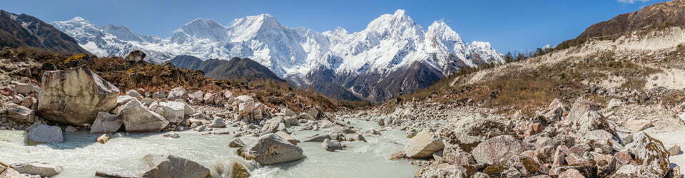
This morning I followed the rivers and creeks across to Paddy Rushs Bogong. This was a great easy going route of gentle gradient and no trees. The views from Paddy Rushs Bogong are superb. Being high and directly opposite Thredbo ski resort it looked just like the Thredbo Resort map. Of course the view was much more extensive than this, check out the photos and panorama to see for yourself.

Thredbo Ski Resort from Paddy Rushs Bogong
My plan had been to ski down to and across Bullock Yard Creek and then climb up to Knob Hill. However, the closer I got the less tempting it became. The descent into Bullock Yard Creek is pretty steep and descends through thick stands of snowgums. With unforgiving snow, which was soft and deep in places then very firm in others, I dreaded the prospect of retracing my steps. The ski down itself yielded only a handful of turns as there wasn’t enough space between those darn trees!
Arriving at Bullock Yard Creek it became clear that the climb up to Knob Hill was strewn with closely spaced obstacles in the form of exposed bushes, rocks and trees. Going up might be OK but coming back down would have been very hazardous. A good time for lunch.
From here I enacted Plan B (conceptualised on the dreaded descent before lunch). Now being at about 1600m there was plenty of exposed shrubbery along
Bullock Yard Creek but it provided almost continuous snow and a gentle gradient. Following it to the saddle above Teddys Hut was straightforward. I was happy not to have to go back up the way I had come.

Teddys Hut and Mount Terrible
From the saddle above Teddys Hut I sidled around towards Mount Leo. Although there were plenty of trees and a few short steep sections to negotiate it meant I could save an unnecessary descent to Teddys. Once into the valley in front of Mount Leo I was back onto open terrain and returned to camp by the same route I had used yesterday.
In my first three days out I have not seen one other person. However, I did cross fresh tracks in a couple of places including to Paddy Rushs Bogong. These all traced back to the bivvy bagging temporary resident of Teddys Hut.
The late afternoon and night saw the clouds largely dissipate, finally providing an opportunity to try some time-lapse photography.
Brindle_Bull_Hill_Sunset Timelapse
href=”http://photos.ssdavies.net/2018/0824tl/20180824_Brindle_Bull_Hill_Night.mp4″>Brindle_Bull_Hill_Moonlite Nightime Timelapse
Day 4: Saturday 25/08/2018 Brindle Bull Hill – Thredbo River Side Creek
NSW Nordic Ski Club Weekend Participants: Damien Aggio, Sam Cooper, Jonathan D’Arcy, Ross Dearden, Bob Doyle (non member day visitor), Ian Griffith (Co ordinator), Scott Griffith (day visitor), Tim Hayes, Roslyn Johnson, Warren Lacey, Wendell Medina, Ian Sim, Jorge Stegmaier
Max elevation: 1872 m
Total climbing: 284 m
Total descent: -518 m
Average speed: 5.78 km/h
Total time: 04:39:25
A busy start to the day. Time to move on. Whilst packing, the solar panels were again hung in a nearby tree to recharge multiple devices. An iPhone, route tracking watch, DSLR camera battery, UV water sterilizer and battery pack (the sun isn’t always shining whilst skiing!)
Todays objective was to meet up with Ian Griffith’s NSW Nordic Ski Club’s beginners snow camping trip. So, after translating the paper map grid reference he had texted to me into my GPS device (Memory Map Topo on my iPhone) I had somewhere to aim for. This involved a 250m sidling descent which crossed three creek valleys through sections of tightly packed living and dead trees on a partially frozen snow base, treacherous conditions with a heavy pack. Being particularly cautious trying to turn was ruled out, instead I’d find gentle straight runs across the slope so as not to build up speed and run the risk of losing control. It quickly became apparent that this would be easier said than done, so the option of ducking under branches and just smashing through thinner dead branches was taken up. Of course, where possible, open spaces were sort out.
Eventually, after covering about 4km, I was in the designated valley and out of the trees. Even here the going wasn’t easy with breakable crust to contend with. Once at the meeting point there was no one to be found. Had I made an error on the waypoint calculation? Where should I look now? Time for lunch!
With lunch finished and facing a decision, the first of a dozen heads started to appear over arise. Yeh, I finally had some company after not having seen anyone else for three days.

NSW Nordic Ski Club members arriving at camp
The selected campsite quickly took shape and Ian had even organised for a portable toilet be brought in on sled, great idea with such a large group. A seating circle was dug for mealtimes and some of us had a few ski runs on an adjacent hill, in slow heavy sticky snow, it was just hard work and inconsistent. None of us persevered for very long.
A campfire atmosphere ensured as we all sat around our seating circle and tried to get to know a little about each other. As it was a little chilly for most it wasn’t long after dinner that people started heading off into their tents.
Day 5: Sunday 26/08/2018 Creek Camp – Thredbo River – Teddys Hut
Max elevation: 1735 m
Total climbing: 386 m
Total descent: -390 m
Average speed: 4.95 km/h
Total time: 05:25:40
There wasn’t much early activity this morning. Most were still enjoying the warmth of their tents after some overnight rain.
Once up, all the action centred around the sitting circle and conversation. With time marching on and Ian wanting camp packed by about 11:00am there wasn’t much chance for any quick ski tours!
As snow conditions were best suited to doing a tour I said my goodbyes to the group and headed out for a day return trip to Teddys Hut (again, three out of the last four days).
After sidling around the valley I was onto The Cascade Fire Trail. A very short distance later I ignored the Cascade Trail Bridge across the Thredbo River and continued upstream on the left hand side (true right bank). Being at around 1600m there were plenty of patches of grass and small bushes emergent from the snow all the way along the valley. Sticking a little higher than the river itself provides the best snow coverage.

Thin snow cover near Boggy Plain
As the valley narrows and steepens, moving even further away from the river works very well. Two groups of Brumbies, eleven in all, were encountered along the way, as were a number of massive piles of their dung! I had quick chats with a couple skiing out from an overnight camp and a group of three people on snow shoes who were out for a short day walk, I encountered no one else for the rest of the day.
Cool, mostly cloudy so far. Arriving at Teddys Hut in just under two hours I took an hour long lunch break to really enjoy the warmth of the sun now there was only an occasional passing cloud and puff of breeze.
I returned to camp following my own tracks, also in just under two hours. This had been an enjoyable, very straightforward day trip.
I was very grateful that the forecast possible thunderstorm didn’t eventuate and that I was able to enjoy a calm and mild evening back at camp.
December 2006 to 26/08/2018
Day 6: Monday 27/08/2018 Creek Camp – Jerusalum Hill – Cascade Trail Carpark
Max elevation: 1826 m
Total climbing: 719 m
Total descent: -805 m
Average speed: 5.85 km/h
Total time: 06:00:56
A little overnight snow or, more likely, very heavy frost. A colder night than the last few had the snow surface frozen hard. With a maximum forecast of -1 it was sure to be a slippery day.
Being my last day I half packed before heading out towards Jerusalem Hill which sits along a ridge which runs east from the high point of the Cascade Hut track. The topographic map indicates a wide gently undulating ridge.
A couple of brumbies were again seen grazing just upstream from the footbridge which crosses the Thredbo River on the Cascade Trail. From here and up the first 300m of track there was plenty of grass, enough to have the skis off for a bit. Good but very firm cover beyond. The step pattern on my Madshus Epoch’s really struggled to maintain grip on this frost covered frozen surface, necessitating the use of skins on a number of not so steep climbs.
My route selection along the ridge, was mostly off the top towards the southern side. This managed to avoid the rocky outcrops found on top.There were initially only a few sections of dense trees, in softer snow this would be a great day trip with extensive views.

Jerusalum Hill
Approaching Jerusalum Hill conditions become a lot more challenging. The descent to the saddle at its base is thickly wooded and was very challenging on such a hard snow-base. Additionally, Jerusalem Hill itself was a little steeper and had very patchy snow cover. So instead of continuing I had lunch and then turned back.
There were few safe opportunities for turns on the way back, it was still too firm and unforgiving and there were lots of obstacles to avoid, especially the frozen tracks from Bobs Ridge back down to the Thredbo River. Here I caught up to a couple who were out for a day trip, the only other people I saw out skiing today.
Back at camp I finished packing and started heading out. With the snow still rock hard and lots of frozen tracks to content with I skinned it most of the way. It was good to get back to the car without a hard fall.
For the next four nights I camped at Thredbo Diggings, enabling me to make some good use of my Epic season lift ticket for Perisher Valley. In over forty years of backcountry and telemark skiing, this was the first year I had ever bought a season pass. In fact I had only lift skied less than ten days in the last 15 years! I’m sure I got more good telemark turns in inside my first two runs on the groomed downhill slopes than in my previous six days in the backcountry, such was the difference in the skiability of the snow.
A detailed, searchable trip list with links to reports, photo galleries and other content
![]()