
17/06/2012 – 20/06/2012 Long Gully – Mount Owen – Shrouded Gods Mountain
Morton National Park, NSW
Yuin country
Participants: Steve Davies (Leader, Photos, Report), Dave Whitelaw, Fred Zickar
Day 1: Sunday 17/06/2012 Long Gully – Cooyoyo campsite
Our planned trip was delayed by two days due to the wet and windy weather conditions forecast for the Saturday. This reduced the original party of six down to the three without work commitments who also agreed to add another day.
This route was reconstructed from memory using Google Earth Pro and GPS Visualizer.
Max elevation: 691 m
Total climbing: 733 m
Total descent: -245 m
Average speed: 2.80 km/h
Total time: 04:16:35
Despite the many trips each of us had completed to these parts over the last twelve months we managed to get lost on the drive in! We put this geographic embarrassment down to being totally engrossed in our conversations at the time and blindly trusting that the driver knew where he was going. [well the driver was probably just enjoying the driving on the irregular road so much and not actually paying attention to where it lead! Lol – Fred] [The detour on the way in was a bit embarrassing but I’ll blame Fred for his furious rally driving and for my slow comprehension to realise the mistake – Dave] We were totally unaware until 20 minutes into the detour and thinking that we should be just about at Long Gully when we noticed a sign to Mogood lookout (which is on Clyde Ridge Road). Finally the penny dropped that something was wrong. We checked the lookout out to find The Castle appearing as a distant view. Perhaps our driver will now be known by the nickname of “Lookout”.
The aim of this trip had been hatched during the SCBW May trip to The Castle and Monolith Valley when this same group of three all decided a more detailed exploration of the area around Monolith Valley was highly desirable. Apart from Fred’s repeated attempts to have us move onto Sunset Cave for a couple of nights a determined trip leader decided it best to base camp at Cooyoyo and day trip from there.
 Dave crossing Yadboro River
After a 1:30pm lunch at Long Gully we headed up Kallianna Ridge to our base camp at Cooyoyo arriving at 4:15pm. Highlights of the day included the strong wind, group of 20 heading down off the Castle, the evening view from the awesome platform at Cooyoyo and of course Mogood lookout.
Day 2: Monday 18/06/2012 Cooyoyo campsite – Mount Owen return
This route was reconstructed from memory using Google Earth Pro and GPS Visualizer.
Max elevation: 879 m
Total climbing: 696 m
Total descent: -695 m
Average speed: 0.00 km/h
We departed camp at 9:15am and followed the standard route into Monolith Valley arriving at 9:40am after a few side trip investigations along the way. Another two hours of clambering up rock faces and over moss covered boulders in dank dark gullies brought us up to our first major views of the day from the top of Mount Owen. Morning tea and numerous photos later saw us on our way again following the cairned route from East to West across the Northern flanks of Mount Owen to its Western end and more views towards Bibbenluke Mountain and Corang Peak. From here the cairns head south along the western edge to the very southern tip. Magnificent views swinging around from Corang Peak through the south to The Castle in the east ensured a very pleasant lunch break. After signing the logbook we started retracing our steps just before 2:00pm. A missed cairn or shortcut, depending on one’s point of view, saw some thick scrub bashing before regaining the cairns. This was some feat considering the cairns seemed to repeat every 10 to 20m and we had three pairs of eyes looking out (but I guess our record wasn’t that good, can’t forget how we got to Mogood lookout).
 Dave clinging on
 Never trust the leader’s navigation skills
We had wanted to cross Mount Cole but as we were unsure of how long that would take we opted for the more cautious option of returning the way we’d come. That, combined with the fact Fred and Dave both thought their headlamp batteries had seen better days. After dropping off Mount Owen at 3:00pm we arrived back at camp at 4:40pm in good time to set up the tripods and catch the sunset from the lookout.
Day 3: Tuesday 19/06/2012 Cooyoyo campsite – Shrouded Gods Mountain return
This route was reconstructed from memory using Google Earth Pro and GPS Visualizer.
Max elevation: 835 m
Total climbing: 463 m
Total descent: -456 m
Average speed: 0.00 km/h
Steve had items stolen from under his tent fly during the night. I assume the local possum was somewhat concerned about it’s health and cleanliness having made off with a sealed plastic bottle of fish oil and a pot cleaning brush.
We managed to get away from camp by 9:00am for further explorations. This time we continued past the regular Monolith Valley entry point to the north-eastern corner of Mount Mooryan and followed Cooyoyo Creek upstream, the alternate route as marked on the old Budawangs sketch map. After a couple of hundred metres we noted a rocky outcrop above us to the south. A short stretch of scrub later saw us onto rock and climbing towards another magnificent lookout at the eastern end of Mount Mooryan. The cameras got another decent workout before we followed the cairned route west along rock pads and through patched of scrub.
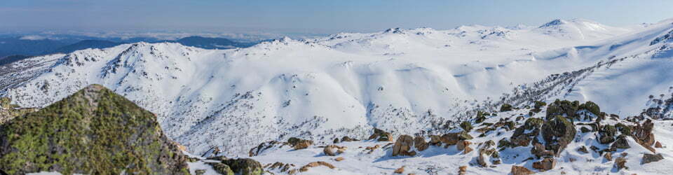
 Shrouded Gods, Talaterang, Byangee and Pigeon House Mountains – from Mount Mooryan
 Fred on the lookout
On entering the next gully the decision was made to cross over to the Shrouded Gods Mountain side and follow its base westwards. [we were later to find this effort was entirely unnecessary, yet the Budawangs sketch map plots the route right up the centre of this gully] More scrub bashing later saw us where we wanted to be at the south-west corner of the mountain. Around this corner and up the gully for more boulder hopping and scrambling saw us at a long chimney. We weren’t sure if this was the right chimney until Steve noticed a black rope hiding beneath fallen leaf litter and sticks. Pulling on the end of rope revealed it to be about 20m metres long and anchored to a big tree at end of the chimney. As this chimney is quite narrow towards the top Steve used his own rope to haul the packs up.
Out of the chimney we turned left, crossed another small gully, hugged a cliff-line for about 100m and made a final scramble over some more rocks before finally achieving the top. Yet more great views and photos, another change of camera angle and a lunch stop took us to 2:00pm and time to head back. [we had quickly dispelled any notion of attempting the circumnavigate of the mountain as noted in a guide book, looking at the thick shrub and the short days we have to contend with] At the bottom of the gully again a short debate followed as to which mountain was which and where we should head had us carefully checking the map before deciding on the correct direction. We were relieved to join the main track at 3:00pm. For our return we headed back via Cooyoyo Creek on Northern side of Mount Mooryan. This time discovering there was intermittent track or cairns marking the whole route back into the creek.
 Evening view from Cooyoyo
 Night view from Cooyoyo
Day 4: Wednesday 20/06/2012 Cooyoyo campsite – Long Gully
This route was reconstructed from memory using Google Earth Pro and GPS Visualizer.
Max elevation: 691 m
Total climbing: 1267 m
Total descent: -1742 m
Average speed: -3.25 km/h
Total time: 04:16:35
Some final morning photos were taken along Cooyoyo Creek and from the lookout before we left camp at 10:30am to head out. The party was slowed somewhat by Steve being a bit of a sook and complaining about a sore calf muscle. Finally back to the cars at 1:50pm.
This trip was memorable for the constant jostling between Fred and Steve for the best vantage point to set up their tripods and Dave’s patience allowing this to happen. The biggest disappointment on the trip was finding a party of three middle aged male Central Coast walkers camped illegally at Castle Saddle. Despite suggesting to them there was a much more suitable camp at Cooyoyo they remained there for three nights. Perhaps the note we left them as we left with give them food for thought. [As we were walking away we were entertained with Steve’s mind going hyperactive with devious thoughts of what else could have written in the note]
Despite achieving the summits of Mount Owen and Shrouded Gods Mountain we all felt the days are too short to explore all the options. We will return to this magnificent area again in the near future as there is much more to discover. I hope that you might join us.
Track Notes
Sunday 17/6/12
1:30pm – depart cars after lunch
2:30pm – arrive cliffline – passed two parties coming out one of 2 people and second of 20!
3:35pm – end of cliffline
Windy and clear
4:15pm – arrive Cooyoyo campground
Monday 18/6/12 – Mount Owen
9:15am – departed camp
9:26am – Castle Saddle
9:40am – Monolith Valley sign
9:55am – Chains, optional route via gully just before and opposite chains on (LHS heading in)
10:30am – Monolith Valley footbridge across creek
11:17am – Exit Point MO1
11:38am – Morning Tea point near top
12:00pm – left
1:05pm – Southern Lookout at log book, Mount Owen
1:50pm – left
3:05pm – left top of Mount Owen
3:43pm – arrive monolith Valley
4:17pm – Monolith Valley entrance sign
Tuesday 19/6/12 – Shrouded Gods Mountain
9:00 am left camp
10:50am – at top of Cooyoyo Creek at SW corner of Shrouded Gods
11:20am – Part way up gully. Turn left immediately after exiting chimney climb gully with black nylon rope, cross over vegetated gully at narrowest point and follow base of cliff-line to the left. This leads to a gully which is climbed to the summit of Shrouded Gods Mountains at waypoint SG01.
12:30 – Top of Shrouded Gods, SG01
Top is heavily scrub covered and not an attractive option of crossing
2:00pm – depart top
3:05pm – join main track at MVTOSG. Head back via Cooyoyo Creek on Northern side of Mount Mooryan
4:35pm – at camp
Wednesday 20/6/12 – Cooyoyo Creek to Long Gully
10:30am – left camp
1:50pm – arrived Long Gully
Clickable icons on a world map which open the related trip report
A detailed, searchable trip list with links to reports, photo galleries and other content
![]()
Hi Stephen, I am heading to the Budawangs at the end of this month and was wondering if you could give me a GR and/or directions to Sunset Cave please? We will be coming from the NW side of Mt Cole.
Many thanks, Annette
I have only just been to Sunset Cave (35°16’46” S 150°10’33” E) with GPS. If you head over to the Contents section and search for Mt Cole you can download my log from 3/4/2016 describing a day trip from Cooyoyo camp site.
Cheers
Steve & Sue