
Sunday 17/06/2018 Bonnum Pic
Nattai National Park, NSW
Gundungurra country
Participants: Mel Adern (Leader), Stephen Davies (Photos), Sue Davies (Report), Kylie Falconer, Frank Mathey
This varied and enjoyable day walk to Bonnum Pic culminates in a spectacular knife edge ridge. There are expansive scenic valley views, interesting geology and some rock scrambling. It is recommended for the cooler months as there is no reliable water supply. However, it would be best not to attempt it when there is a severe weather warning for damaging winds!
Max elevation: 750 m
Total climbing: 988 m
Total descent: -988 m
Average speed: 3.88 km/h
Total time: 06:12:41
We all arrived on time at the meeting spot in Mittagong. From here we all jumped into Steve’s car for the 30minute drive to the start of the walk. Access is via Wombeyan Caves Road west from Mittagong before turning right onto Wanganderry Road, which is followed to the end (a gravel road with a “bus shelter” at the start).
Our walk started from the gate at the “Ben Har” stockyards. As we prepared to start walking the car thermometer was indicating it was 1degree outside, without accounting for the wind chill, so in effect it felt much colder! The forecast for the day had been for very cold and windy conditions. A severe weather warning was issued by the Bureau of Meteorology at 10:51am on Sunday morning, by which time we were well into our walk.
Having rugged up, we headed through the gate, leaving it as we had found it of course, and headed down the dirt road. After about 500m we turned right following a National Park’s sign for the track to the Bonnum Pic. We were a little surprised at the signage at the beginning of the walk which appeared quite frequently, later to be replaced by rock cairns or the dreaded pink tape on trees.
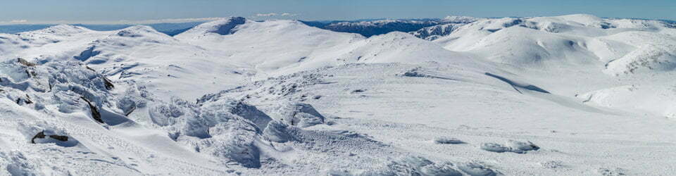
The walking was reasonably level through the forest until we reached a cleared area and had to search for the trail. We then walked along a wide path before leaving it for a more narrow section which lead us to the cliff edge and great views of the the Wollondilly River Valley and the overlapping hills beyond. Along the route there are impressive exposed rock domes which, with the weather conditions (with wind gusts up to 76kph) on the day had us questioning our sanity. I really thought I may have been blown over in the gusts a couple of times. It was much more pleasant most of the time in the shelter of the trees. Occasional gusts had us concerned especially when standing near some large dead trees.

Kylie, Sue and Frank on the western edge of Wanganderry Tableland
There was a bit of a scramble to make it to the top of the ridge and some eroded sections around which care needs to be taken but we arrived at Bonnum Pic in time for an early lunch. The wind abated for a short time and we enjoyed some winter sun before heading back along the same route.
Bonnum Pic is an enjoyable, varied and scenic day walk.
Clickable icons on a world map which open the related trip report
A detailed, searchable trip list with links to reports, photo galleries and other content
![]()
Some spectacular views! Sounds like you had a great walk in wild weather. Rained all day in Wagga and so cold. No outside activity here! Testing the comments modifications!….,
Thanks Geri, I look forward to more comments in the future.
Is the ascent 982 m?
Hi Venkatesh. This is a relatively gently undulating hike where the lookout at Bonnum Pic is about 200m lower in elevation than the start point. GPS tracking recorded accumulated ups and downs to total 982m.
Stephen,
Walked this trail yesterday 27/06/20. Large areas were burnt out during the summer fires of 2019/20. Works are in progress at the northern end of the “Ben Har” property, making finding the start of the trail a little more difficult, This start is still marked by a small cairn and row of stones on the right side of the fire trail. Whole area burnt out with fallen trees over the passage, but now all marked with pink ribbon. Once at the walls it is easier to head north to the Pic due to the amount of scrub burnt. We did not go all the way to the Pic.
Thanks John, I’m sure anyone who comes across this page and reads your comment will be greatly appreciative of this updated information regarding the post fire status of this walk.