
Friday 11/12/2020 Guthega Power Station – Munyang Geehi Road (Schlink Pass Road) – Horse Camp Hut
Kosciuszko National Park, NSW
Ngarigo country
Participants: Stephen Davies (Photos, Report), Sue Davies
Our last walk in Kosciuszko National Park for this trip needed to be fairly short in order to catch up with some High School friends in Canberra later today. Having camped at Island Bend meant a walk up Schlink Pass Road from Guthega Power Station, which we have frequently travelled in winter, might be a nice option to see without snow cover. It would also provide an opportunity to investigate alternative routes.
Max elevation: 1617 m
Total climbing: 656 m
Total descent: -661 m
Average speed: 4.63 km/h
Total time: 02:56:15
We were blessed with really nice walking weather as we departed the National Parks car park just before the bridge at Guthega Power Station. Our first aim was to check for a crossing point over Munyang River as the old bridge that was there was deemed to be unsafe and was removed several years ago. I had encountered skiers on previous trips who had rock-hopped somewhere near the site of the old bridge to gain access to the aqueduct trail that passes Disappointment Spur Hut before rejoining Schlink Road about 600m before White River Hut. Closely checking out the options from on top of the river bank quickly had me decide you could cross but would need to be prepared for a steep, loose, gravelly climb on both banks and some dodgy-looking boulder hopping over the water. This looked to me like a potentially trip ruining exercise that would be best avoided when lugging around a heavy winter backpack and skis whilst wearing ski boots. I’ll stick with Schlink Pass Road.

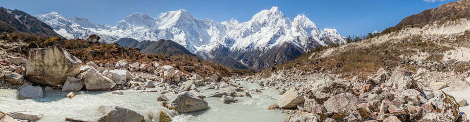
Schlink Pass Road from Horse Camp Track
Our slow pace today was our reward for the two big days we had just completed. Taking our time we were able to spot and enjoy the wildflowers which were plentiful in the meadows. It wasn’t long before we had arrived at the sign-post at the start of Horse Camp Hut track, just a short distance up from the crystal clear waters of “Horse Camp” Creek. To this point and a long way past Schlink Hut you are walking along a gravel road, so we were now very pleased to be on a grassy vehicular track walking through alpine meadows and patches of snow gums. Horse Camp Hut, about 400m from the turnoff, reveals itself via its bright red door through a patch of trees. It is set on an open grassy area surrounded by snow gums. It was built in the 1950’s by the Snowy Mountains Authority for surveying.
Today two tents were pitched nearby. I was able to chat with one solo hiker and offer some suggestions on how she might be able to fill her limited remaining time. From here we headed up the short steep hill behind the hut onto the Snowy Hydro track in order to investigate it as an alternative option for winter. This appears to be an active 4WD track for servicing Snowy Hydro infrastructure. Here we found the snow gums to be taller than near the main road and the undergrowth thicker. We also crossed several short steep dips along of about 10m on this route. Again, like the earlier Munyang River crossing option, I decided the road in is an easier option for carrying a heavy winter pack on skis. I would like to check out this route in the other direction up towards White River in winter but would most likely try this first without carrying a pack!
We were back to the car by 10:00am having completed this short excursion in three hours. From here we headed back to Island Bend to pack up a now dried out tent and head off to Canberra as planned.
Clickable icons on a world map which open the related trip report
A detailed, searchable trip list with links to reports, photo galleries and other content
NSW National Parks signage at the start of this track states
The Australian Alps Walking Track
650 kilometres of mountainous and often remote walking. Along the way the track passes through spectacular country: grassy high plains, towering mountain forests, tranquil snow gum woodlands and rugged alpine summits.
Thousands of years ago Aboriginal ancestors formed intricate pathways across this whole region.
Their journeys were to find food, and conduct spiritual, cultural and Important intertribal business.
Early settlers are known to have followed these routes, or were guided into the high country by Aboriginal people. Today the Australian Alps Walking Track overlies many of these ancient pathways – a shared significance that links people, places, times and events.
Guthega
High above the Snowy River valley the lofty peaks and plains of the Main Range dominate the landscape. And when the Weather is wild ‘up top’ following the Australian Alps Walking Track via Guthega Power Station is the only option.
Rangers can tell you more about the Australian Alps Walking Track.
Call Snowy Region Visitor Centre on 02 64505600 or visit www.australianalps.deh.gov.au
Snowy Hydro Sign
Guthega Power Station
Guthega Power Station generates electricity from the waters diverted through the Guthega Pressure Tunnel from the Guthega Pondage and afterwards discharging the water into the Snowy River via the tailwater bay.
Power generated is transmitted to the Murray Switching Station for distribution to New South Wales and Victoria.
Guthega Power Station has a generating capacity of 60 MW.
NSW National Parks signage at the start of this track states
Welcome to Munyang
Seasons govern plants, animals and people’s use
Here at 1320 metres you are at the edge of a sub-alpine woodland. Climate and altitude affect everything in Kosciuszko National Park’s alpine and sub-alpine areas. The annual snowfall governs the life-cycle of plants and animals and has determined how people have used this area for at least 400 generations.
spring
When the snow began to melt each spring, Aboriginal people collected yam daisys to eat the meewan (tubers). Munyang comes from the local Aboriginal word for this native dandelion.
The melting snow signified something quite different to struggling settlers in the dry interior of south-eastern Australia. In 1949 the Snowy Mountains Hydro-electric Scheme was launched to divert the eastward flowing rivers, into which the melting snow ran, to irrigate inland crops and generate hydro-electricity.
winter Ski touring has been popular through this area since 1927 when Dr Herbert Schlink and his party were the first to from Kiandra to the Hotel Kosciusko (now Sponar’s Chalet).
The cover of snow protects wildlife from extreme temperatures. Endangered mountain pygmy-possums hibernate under snow for most of winter. These tiny marsupials were thought extinct until one was found ski resort in Victoria in 1969. Not much was known about their habitat until they were first recorded in the wild near boulders upstream from Schlink Hut.
Summer
Aboriginal people from across the south-east of Australia travelled to the high country in spring and summer to join the local Monaro (Maneroo) people in ceremony. The pilgrimage was to pay respects to the spirits in the mountains.
Many plant foods and animals were abundant at this time of the year, allowing large groups to gather for long periods. Bogong moths were collected and were much part of the ceremonies as the feasts. This time also allowed different groups to forge relationships through marriage and trade.
In the 1840s graziers brought cattle to the high country for summer grazing. They built simple timber huts and fences, some of which can still be seen.
Today, millions of bogong moths continue to migrate to the high country escape the heat of the inland plains. Many local birds and mammals feast on these moths. Mountain pygmy-possums rely on them to fatten up for their winter hibernation beneath the snow.
autumn Seeds and fruit from many plants provide food for birds and mammals after the bogong moths leave. Fruit from the mountain plum-pine is a favourite of tiny mountain pygmy-possums and crimson rosellas.
These slow-growing shrubs cling to rocks and boulders where mountain pygmy-possums often live. With the winter snow approaching, these plants must take advantage of the warmth the rocks capture from the sun.
Jagungal Wilderness Area
This area provides opportunities for wilderness experiences in a snow environment.
At 67,432 hectares, the wilderness area encompasses a large high plateau centred on the majestic Mt Jagungal (2061 metres). It also includes the Kerries, Brassys, Toolong Range and the Dargals.
The Jagungal Wilderness area is an important catchment for the Murray and Murrumbidgee rivers whose tributaries, the Tooma, Geehi and Tumut rivers, all rise near Mt Jagungal.
There are relatively few man-made features in this area. Aboriginal relics, huts and gauging stations are reminders of how this area has been used over time. Some huts, such as Mawsons and O’Keefes, are linked to the area’s grazing history. Huts such as Derschos and Valentines were built during construction of the Snowy Scheme and others, such as Tin, were built for ski touring.
Tall forests to alpine wildflowers
The moist slopes of the western ranges support tall forests of mountain ash and mountain gum. The higher country, between 1400 and 1850 metres, is dominated by sub-alpine woodlands of snowgum and naturally treeless frost hollows. In the alpine area above 1850 metres, herbfields and bogs provide a spectacular display of wildflowers during summer.
An ancestral being
Many of the mountains are regarded by Aboriginal people as ancestral beings, with Mt Jagungal being one of the most significant. It was the site for major ceremonies in which only highly initiated men took part.
NSW National Parks signage at the start of this track states
Wilderness means different things to different people
Wilderness areas are large, essentially undisturbed natural areas in which ecological processes are virtually free of human interference. They are of high ecological and scientific value.
Wilderness areas offer perception of isolation and remoteness from habitation for those venturing into it.
For Aboriginal people, these areas continue to have strong cultural and spiritual significance.
Please respect wilderness areas wild places.
Are you prepared for snow all year?
– warm, windproof clothes and wet-weather gear
– hat and sun protection – UV is high here
– food – it provides heat for the body
– water boil or purify all stream water
Cold can lead to hypothermia
In cold and wet conditions inadequate clothing, tiredness and insufficient food can combine to cause a lowering of normal body temperature. This can result in collapse or death if untreated. Signs of hypothermia are mistaken for fatigue. Treat the victim often immediately by providing shelter and warm, dry clothes, a sleeping bag or shared body warmth.
Plan ahead
– Travel with at least two other people
– Tell someone reliable where you’re going and when you’re due back let them know when you return
– Check weather conditions before you set out change your plans if bad weather is approaching
– Take, and know how to use, a topographic map and compass
Huts are for emergency use only
If you do stay in or around a hut
– Remove food scraps avoid attracting rodents
– Check fires are completely out before leaving – huts have been destroyed by untended fires
– Clean the hut before you leave and close the door
If lost or injured
Get out of the wind and into shelter
– Leave something visible for searchers
– Stay above the treeline if you can so you are visible – only drop down below the treeline for temporary shelter
![]()