
Wednesday 9/12/2020 Charlotte Pass – Foremans Crossing – Carruthers Peak – Mount Lee – Northcote Pass – Muellers Pass – Mount Kosciuszko – Rawson Pass – Seamans Hut
Kosciuszko National Park, NSW
Ngarigo country
Participants: Stephen Davies (Photos), Sue Davies (Report)
A short walking trip away from home before the summer school holidays commence, tied in with a more luxurious retreat for our 33rd wedding anniversary saw us heading off to Kosciuszko National Park again. We had delayed our departure to arrive after a cold wintery change charged through the region with subzero temperatures and snowfalls. Snow was clearly visible across the peaks from before Jindabyne. Certainly not unheard of but unusual for December.
Max elevation: 2221 m
Total climbing: 1260 m
Total descent: -1267 m
Average speed: 4.00 km/h
Total time: 08:24:11
After a cold night camping at Island Bend we were in the car heading towards Charlotte Pass just after 7:00am. We were far from the first to arrive but managed to commence our walk of the Main Range Track shortly after 8:00am. Despite it being 3C the crystal clear calm skies made it feel much warmer. It was a pleasant change having mostly dry land under our feet, in these parts we are much more used to it being snow or ice.
From the top of Charlotte Pass we could see a lot of yesterday’s dusting of snow remained beyond the Snowy River, although it was to disappear pretty quickly as the day progressed. There was just a little too much water at the Snowy River crossing to attempt rock-hoping so the trusty crocs were put to good use again.
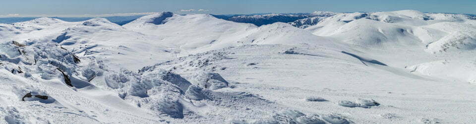
The longest climb of the day now immediately ahead we headed off at a slow steady pace as there was a long day still in front of us. There were numerous sections of track from here to the back of Mount Clarke that were covered with old wet snow, making it challenging to keep the feet dry. We opted out of the short Blue Lake detour, instead climbing to the saddle below Carruthers Peak. From here Watsons Crags was seen to be well covered in snow, whilst Jagungal, off in the distance was completely snow-free. There was more snow across the track up to Carruthers Peak summit.
Views down to Club Lake and surrounds revealed the three turns the young skier we had encountered earlier near Foreman’s Crossing had earned. A lot of work for little return, at least he managed a ski in Australia in December, not too many people can make that claim.
Further around, past Mount Lee we chatted with a guy who had just started the Dead Horse Gap to Tharwa section of the Australian Alps Walking Trail, clearly identifying himself as being on that mission by the AAWT guide book hanging out of his pack pocket. He had remained tent-bound yesterday, waiting out the bad weather. He said that yesterday the higher parts of his route were under cloud.

Sue approaching Abbott Ridge
Of course, by this stage, I had shot many photos and panoramas. The views from the western side of the Main Range never cease to draw your attention, but with the placement of the track between Carruthers Peak and Muellers Pass some way down below the high points, you see nothing to the east again until past Mount Northcote.
It seemed further than it actually was from there around Muellers Peak to the junction with the Mount Kosciuszko Track, perhaps we were starting to tire a little already. This time we did the detour which added another 2km to our already solid day. At this juncture, we also had way more company on the trail. Close to 100 people around the summit whilst we and many others enjoyed the views and lunch. The line up for a summit Instagram shot needed to be seen to be believed! We passed on that option.
We didn’t linger too long as there was still the matter of our 8km return via Seamans Hut along the Summit Track which is actually a gravel road and a small part of the Australian Alps Walking Track (an alternative route to the higher, more scenic Main Range Track). Plenty of cars on it today, cleaning the toilet at Rawsons Pass and lots of work being done around the Seamans Hut, there were two people on the roof doing repairs and a small team working on a brand new toilet. It’s stonework blends in perfectly with the hut, so well done to National Parks planners.
The pounding on hard road surface past the hut was a bit too much for my feet as we passed the 20km mark for the day. The sole of the left foot developing an uncomfortable hot spot that could not be placated with a change of socks and shoes. I must be just getting old and soft.
We ended up back at the car by 4:30pm after completing 25km across the top of Australia on a cool calm clear day. It had been an excellent day walk.
Clickable icons on a world map which open the related trip report
A detailed, searchable trip list with links to reports, photo galleries and other content
NSW National Parks signage at Charlotte Pass states
Australia’s highest mountains worn down by wind, rain and ice
All mountains evoke images of grandeur, strength and size. While the ancient Kosciuszko mountains towered over the landscape, they were worn down by millions of years of rain, wind and ice. Now they are more rounded and lower than younger mountains such the Himalayas, Andes and New Zealand Alps.
To see the exception of the steep, rugged western fall, walk the Main Range track.
Kosciuszko National Park’s alpine areas, the largest mainland Australia, cover only 250 square kilometres. Alpine areas around Mt Kosciuszko cover 100 square kilometres.
We must continue to find ways to sustainably use alpine areas as they make up such a small part of Australia.
Glaciers shaped this ancient landscape
“Our observations have finally set at rest a vexed question, and have entirely confirmed the view that the ‘Roof of Australia’, at no distant date, certainly supported glaciers.” Edgeworth David, Geologist, 1901
You are in the alpine area where it’s too cold for trees to survive. Snow will sit here all winter and persist in small patches until late summer.
Now picture the view between 10,000 and 30,000 years ago permanent snow and ice compacting and moving down this side of the mountains as rivers of ice called glaciers.
Slowly moving glaciers acted like giant brooms
When the glaciers slowly moved they took rocks and soil with them creating all of mainland Australia’s glacial features:
– glacial lakes
– cirques – semi-circular basins formed by rocks taken from the head of glaciers
– moraines – piles of rocks carried downhill by glaciers
– erratics – glacially deposited boulders and
– rock markings – deep grooves and scratches
Later, other features such as terraces and shattered rocks resulted from the continuing cycles of freeze and seasonal thaw. This continues today.
“Aboriginal tradition says that the ancestral beings, some in the form of giant animals such as kangaroos, emus, echidnas and wombats, shaped this landscape as they journeyed here looking for food.” Rod Mason, Aboriginal Education Officer
Climate dictates alpine life
Climate influences everything in Kosciuszko National Park’s alpine area the landscape, plants, animals and the activities of people.
Alpine areas worldwide occur where the average temperature during the warmer months does not exceed 10 C. This is too cold for trees to survive. The altitude of alpine areas varies throughout the world- here it begins at about 1850 metres.
This is one of the few places in Australia where snow will sit all winter and persist in small patches until late summer or even autumn.
Mountains influence the weather
Mountains everywhere trigger rain and snow. Here they block the prevailing westerly airstreams, forcing air to rise, cool and form clouds. You must therefore be prepared for wet weather, snow and strong winds all year round.
Charlotte Pass recorded the lowest temperature in Australia at -23C.
The local rainmaker, Dyilligamberra, represents all the rain, snow and water from these mountains to the sea. His relatives make the wind and clouds. They are all very powerful, so we show our respect by going quietly in the mountains.
Mountain by paths forged people over time
Aboriginal people were the first to interpret the mountain landscape and express their relationships with the land through their daily lives, song, dance and stories.
As many groups journeyed here for summer ceremonies, they forged many mountain paths, but left few other marks on the landscape. Many of these Aboriginal paths were in turn used by European explorers, such as the Polishman Paul Strzelecki who named Mt Kosciuszko.
Explorers, graziers, scientists, surveyors, poets, artists and now visitors have all been captivated by the high country and have all left their marks. They renamed mountains and rivers, built tracks and huts, and recorded their adventures, thoughts and findings.
However the beliefs and associated ceremonies which brought Aboriginal people here each summer were not forgotten after European settlement.
The completion of the Summit Road to the top of Mt Kosciuszko in 1909 dramatically increased the number of visitors. In those days very few made the journey to the top. Over time traffic increased and for safety and environmental reasons this read became a walking track in 1976.
NSW National Parks signage on Mount Kosciuszko states
Mt Kosciuszko (2,228 metres)
Below is the text of the sign which was placed here in 1940 to celebrate the centenary of the first recorded ascent of Mt Kosciuszko.
From the valley of the Murray River the Polish explorer Paul Edmund Strzelecki ascended these Australian Alps on 15th February 1840.
A ‘pinnacle, rocky and naked, predominant over several others’ was chosen by Strzelecki for a point trigonometrical survey.’The particular configuration of this eminence’ he recorded, struck me so forcibly by the similarity it bears to a tumulus elevated in Krakow over the tomb of the patriot Kosciusko, that, although in a foreign country on foreign ground, but amongst a free people, who appreciate freedom and its votaries, could not refrain from giving it the name of Mount Kosciusko.
This commemorative plaque was originally unveiled by the Consul General of the Republic of Poland for Australia, New Zealand and Western Samoa, Ladislas Adam de Noskowski Esq; on the 17th February 1940.
Early visitors
It is highly unlikely that Strzelecki was the first person to climb Mt Kosciuszko.
The Aboriginal people of the Monaro and groups from the southern tablelands, south coast and northern Victoria visited these higher peaks for thousands of years to feast on the bogong moths which gather here in summer and to conduct trade and perform cultural and spiritual ceremonies. Stockmen began visiting the mountains from the 1830s in search of summer pasture and it is probable that some of them would have climbed the mountain.
Change of name
In 1997 the Geographical Names Board of NSW agreed to a proposal that the spelling be changed to Kosciuszko’, the correct spelling of the name of the famous Polish freedom fighter.
The board accepted that Strzelecki spelt the name with a ‘z’.
NSW National Parks signage at Rawson Pass states
Gadi Maralang
For scientists, the long sinous shape on the ridge opposite is caused by late-lying snowpatches on the leeward side of the ridge. When the snow does melt, stony ground is exposed.
However for local Aboriginal people this is the final resting place of the ancestral brown snake spirit, Maralang. The general word for brown snakes is Gadi.
Ancestral snakes have stories all over Australia, many to do with particular landscape features such as valleys and gorges which they formed on their travels.
The local story of this snake tells of a time when turtles were poisonous and snakes were not.
The snake crept into the turtles’ camp which was not far from here and stole their poison. He then distributed it to other snakes while being pursued by the turtles. Some snakes, however, refused to accept the poison and fled into the hills, creating landscape features as they fled.
Maralang journeyed north along the Great Dividing Range, forming various valleys as he went, until his progress was halted by the rainforest python spirit. He then travelled into the deserts. Still being pursued by the turtles, he returned here to Tidbillaga and this is where he remains.
Information on these signs was provided by Rod Mason, NPWS Indigenous Education Officer
Maliyan, the ancestral eagle
Many stories of the travels of Indigenous ancestral spirits from across Australia intersect here where local Indigenous people believe the old spirits meet and dance. This area is called Tidbillaga.
The complex details of these stories would fill many books and certain information is only available to those who are qualified to receive it. Some of these stories might take weeks to recount and be accompanied by song and dance. We can only present brief outlines of these stories.
One such story tells of the ancestral eagle, Maliyan, who brought fire to south-eastern Australia. This rocky country is his old camp and hunting ground. There are three important laws for country in Tidbillaga Wind, Rain and Fire.
The eagles are associated with Fire and fire spirits. Some of the smaller raptors such as kites, kestrels and owls are associated with both Wind and Fire.
The rocky outcrops are the camps of some of these birds. The loose rock sliding down from the ridges are the remains of the food eaten by the ancestral tire birds and discarded from the nests.
The senior men associated with Fire law met here every year for ceremonies and secret meetings. From south of the Murray came the Gippsland Yerrung (Eagle-hawk men) who met the Merrung (Eagle-hawk men) from the Monaro. They met near Dead Horse Gap and travelled up together to Lake Cootapatamba.
Information on these signs was provided by Rod Mason, NPWS Indigenous Education Officer
Dyillagamberra, the local Rainmaker
Ahead the country changes from sharp, rocky ridges to a more rounded and vegetated landscape. This is rainmaker’s country, the home of the local Rainmaker, Dyillagamberra. His main camp is Blue Lake which is just beyond the ridge to the north of Club Lake (you can see the Club Lake cirque).
The term ‘rainmaker’ can be misleading because it has become associated with other cultures and restricted to the idea of summoning up rain. In Aboriginal culture its meaning is far wider and takes in everything associated with water, including plants, animals and country.
Those people associated with the Rainmaker through family are also known as ‘rainmakers’.
Rainmakers’ have special responsibilities for all things connected with water.
The senior men associated with Rain law met at Blue Lake every year for their ceremonies and secret meetings, part of which involved asking Dyillagamberra to keep the rivers, springs, waterholes and swamps full while they were visiting and travelling through country.
One of Dyillagamberra’s sons, Garrugalla, lives in the clouds which form above the Main Range. He is responsible for making snow, ice, frost, dew and cold winds. These are distributed by the ice-spirits, nyinya, who live here in caves and rock crevices. The local name for snow is gu-nyinga.
Blue Lake is the main camp of the local Rainmaker Dyillagamberra.
Information on these signs was provided by Rod Mason, NPWS Indigenous Education Officer
Mountain tops – places where spirits dance
This area is a very special place. Everything should be respected especially the big rocks and the high mountain tops. The spirits of our old people (the early travellers) who came here still live on in them. Please go quietly, please go respectfully. Rod Mason, Aboriginal Education Officer
From here you will ascend to the highest peak in Australia at 2228 metres -Mt Kosciuszko. By world standards this is not high. Younger mountains such as the Himalayas have towering peaks over 8000 metres.
Aboriginal people visited here for hundreds of generations
For thousands of years Aboriginal people from all directions visited these mountains to participate in ceremonies and learn their ancestors’ stories. However for spiritual reasons they rarely went to the highest tops, closest to the stars, where the spirits dance.
Explorer Paul Strzelecki named the mountain Kosciuszko
In 1840 Polish explorer Paul Strzelecki named Australia’s highest mountain after the Polish freedom fighter General Tadeusz Kosciuszko whose tomb is similarly shaped mound in Krakow. The mountain has increasingly become a focus for the Polish community.
![]()