
30/07/2022 – 2/08/2022 Guthega Power Station – Guthega Power Station – Munyang River – Disappointment Spur – Disappointment Spur Hut – Schlink Pass Road – Dicky Cooper Creek – Schlink Hut – Duck Creek – Valentine Hut – Valentine Creek – Mawsons Hut – Tin Hut – Dead Horse Creek Saddle – Gungartan Pass – Schlink Pass Road – Munyang River – Guthega Power Station
Kosciuszko National Park, NSW
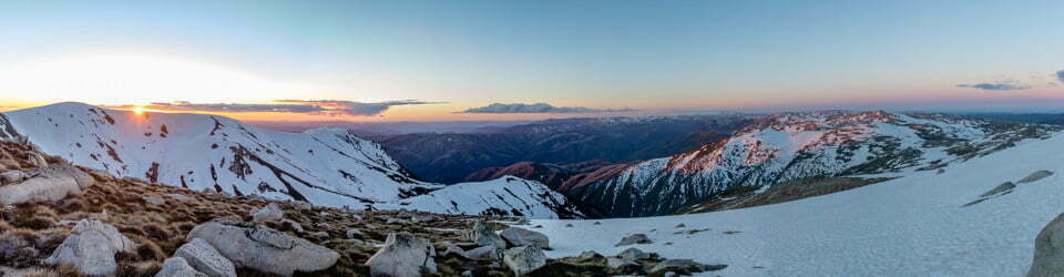
Ngarigo Country
Distance: 63km Total Ascent: 3,000m Total Descent: 3,000m Time: 22 hours
Participants: Damien Aggio, Stephen Davies (Photos, Report), Tim Hager, Paul Jennings (Leader)
I was keen to join in on Paul’s posted five-day New South Wales Nordic Ski Club trip. He had advertised a very interesting trip entering via Scammels Lookout Road, with a plan to visit Pretty Plain Hut, Grey Mare Hut, O’Keekes Hut and Jagungal. Approaching the start date it became obvious there would be a distinct lack of snow along the proposed route, so he came up with an alternate plan. We all spent Friday night at Paul’s newly purchased property outside of Berridale so we could make an early start on the planned long day skiing from Guthega Power Station to Mawsons Hut.
Day 1: Saturday 30/7/2022 Guthega Power Station – Munyang River – Disappointment Spur – Disappointment Spur Hut – Schlink Pass Road – Dicky Cooper Creek – Schlink Hut – Duck Creek – Valentine Hut
Max elevation: 1808 m
Total climbing: 1202 m
Total descent: -844 m
Average speed: 4.67 km/h
Total time: 07:50:40
We left Guthega Power Station around 9:00am, our first challenge, crossing Munyang River to get onto Disappointment Spur Trail, came minutes later. After a very cold night, this proved to be a very tricky and time-consuming exercise. The steep banks on both sides and rocks in the riverbed had a thin, mostly invisible veneer of ice covering them. We removed our boots and then tentatively worked our way through the water, trying to fully immerse our feet in order to avoid any ice. Even the soil up the opposite bank was frozen hard and slippery in places, this was a very hazardous crossing! As I was the only one to have brought crocs (specifically for any water crossings – my soft feet with a heavy load through a near-frozen, uneven, rocky surface solution), I got across relatively quickly.
As I had a plan and the supplies to complete a ten-day trip, I started up the aqueduct before the others had finished their crossing so as not to slow them down. Also, knowing there was a long day ahead, I deliberately made every effort to pace myself so as to expend the least possible amount of energy along the way. I commenced the climb using climbing skins to achieve the best grip on the initially icy, patchy cover. We reached continuous snow just below the 1500m mark.
Nearing Disappointment Spur Hut, I caught up with a couple of split-boarders who were planning their weekend trip around that hut. Paul, Damien, Tim and I caught up again here. After a short break and the removal of my skins, I again headed off first, sure I would be the slowest member of our group as I had by far the heaviest pack.
The cover was amazingly good, having a light topping of fresh, dry snow, which made the skiing very pleasant. As I reached the junction with the Schlink Pass Road, I met Murray, who was retreating due to an injury concern. He informed me his party of fifteen was based at Mawsons Hut, and that they were planning a Jagungal day trip today. Our leader, Paul, was not too happy to hear that we would have so much company at Mawsons Hut tonight.
We paused briefly at Schlink Pass. From here, we followed mixed routes down to Schlink Hut. Damien and I followed the valley along Dicky Cooper Creek, as I found my right ski was balling up if I attempted to ski in any existing tracks, but would run nicely if I stayed on fresh snow. We regathered at Schlink Hut for a late, 2:30pm lunch break. Here we met three Czech snowshoers who were out for the weekend.
Tim and I waxed our skis before continuing. We now enjoyed a great run further along the road to our turnoff point near the small roadside quarry. Our shortcut through the trees had us quickly to our next navigation point, the Meteorological Station. From here, there was a short descent to the snow bridge creek crossing below before we climbed up to the saddle at the top of Duck Creek. This short climb was the steepest section of the day by far, and Tim, in particular, had some issues with grip.

Damien skiing along Duck Creek
The run-down Duck Creek was a fantastic one on the still-dry surface snow, vastly better than my 2019 descent on a rock-hard surface. Just before the left-hand bend in the creek, about two-thirds of the way along, we climbed out of the creek to follow the road to Valentine Hut. Although it was now about 5:00pm we were still mostly in sunlight, as we had been almost all day. Along this route, we caught sight of some awesome clouds rolling in behind us.
A final short climb and then descent had us at Valentine Hut with daylight to spare. After a long day, I think we were all very happy to finally take our skis off. At lunchtime, Paul, with some consultation, had made the call to head here instead of Mawsons Hut in an attempt to avoid the large party we knew to be there. We couldn’t believe our luck, as despite there being plenty of tracks to and around the hut, there was no one else there.
We had a very pleasant evening in the hut. Paul got the pot belly going, and we all tried our best to name the transition of colours up the glowing chimney.
Disappointment Spur Hut Logbook 14/11/2014 – 29/7/2022
Valentine Hut Logbook 12/12/2020 – 29/7/2022

Day 2: Sunday 31/7/2022 Valentine Hut – Valentine Creek – Mawsons Hut – Tin Hut
Max elevation: 1900 m
Total climbing: 841 m
Total descent: -654 m
Average speed: 4.79 km/h
Total time: 06:11:16
Damien’s report of Day 2: The hut last night was very warm, and most of the night was spent with the sleeping bag open. The subsequent morning was beautiful and pleasantly warm outside. As we skied off at 9:00am to head to the Big Bend on our way to O’Keefes Hut, the weather deteriorated. At our first downhill, a couple of falls were experienced in the flat light. Steadily as the day progressed the weather got worse and at the snow bridge at the Big Bend we changed our planned destination to Tin Hut. That way we would be skiing with a tailwind instead of a headwind into the developing blizzard.

Sunrise at Valentine Hut
We retired to the nearby Mawsons Hut for lunch at 12:00pm. There we found a crew of eight encamped near the Hut as a base for a guided educational tour. They were temporarily exiting for a day trip as we entered, which made for a roomy and also warm venue as the fire was still running.

Paul gathering water from Valentine Creek
After lunch, visibility became a big problem. It was only with the assistance of the GPS app on Stephen’s phone that we were able to get all the way to Tin Hut at 3:30pm.
Paul immediately started a fire to dry all our wet gear. Luckily, the small hut was empty, even though the logbook showed someone had dropped in earlier that same morning.”
Shortly before dark, Paul and Tim ventured out to collect some fresh water. There is a good, reliable open water spot down the Finns River at the first small grove of trees. Damien and I were happy to melt snow and avoid having to venture outside again.
Conditions were so miserable in the evening that I abandoned an attempt to reach the nearby toilet. Although I was halfway there, my headlamp didn’t reveal its position, and I wanted to make sure I got back to the hut!
Mawsons Hut Logbook 4/3/2021- 29/7/2022
Day 3: Monday 1/08/2022 Tin Hut – Dead Horse Creek Saddle
Max elevation: 1912 m
Total climbing: 253 m
Total descent: -274 m
Average speed: 3.83 km/h
Total time: 02:06:37
The howling blizzard continued throughout the night, so we were all very pleased to be cosy and warm inside the hut. Tim opted to sleep on the floor, as, despite there being four bunks, they are too short for two adults to sleep end to end without overlapping. Paul and I shared the bottom bunk, both keeping our feet on our left-hand sides, which worked well.
As morning broke, the gale had eased off just a little, so I ventured outside to get some photos whilst everyone else slept in.

Tin Hut
After a longish visit to the now visible toilet, trying to get a stubbornly resistant door closed, half of my 15cm deep boot impressions were no longer visible, due to the volume of spindrift around. Returning to the toilet with a shovel in hand didn’t help get the door closed, but closing the bottom half of the door first solved the problem. There may be a little twisting in the door or outhouse itself.
As the weather outlook for the day looked really poor, we had no enthusiasm for any touring. Instead, the other three went out to collect firewood whilst I worked on taking more photos. When the firewood returned, we worked as a team to de-snow it, get it inside, saw it to length, stack it up and clean up the hut. Damien headed out with my PLB for a solo ski between The Brassy Mountains and Mount Porcupine. He reported that there it was much better sheltered from the wind and he got some good turns in.
Paul, on the other hand, had a big problem with one of his skis. The metal edge on one ski was breaking free from the ski! It was about 1cm out from the ski edge, leaving the sharp, exposed edge opposing any forward motion. My second trip in a row with someone suffering a ski gear failure! Damien and I, as a result of his binding failure on our last trip, had a renewed supply of tape, which Paul used to try to hold things together.
As the wind had eased a little and visibility improved, sometime after lunch, we left Paul in the hut whilst the rest of us went for an afternoon stroll. We headed around to the top of Dead Horse Creek and noted good snow cover right down the valley as far as we could see. There was a route for another day. On our return, Damien had soloed another ski down towards the Finns River whilst Tim and I retraced our tracks back towards the hut. A couple of hundred metres before the hut, we went through a newly established campsite, where we found the other half of the training group we had met at Mawsons Hut yesterday. It can be noted that there is Testra 4G reception along this route, the updated weather forecast was terrible!

Tim and Damien skiing towards Mount Porcupine
Our new neighbours joined us in the hut for dinner. We had trainers from Jindabyne and the Blue Mountains together with their students. We witnessed some training in action where a student would be singled out and asked to present a risk assessment plan for the next day, and then be critiqued. It was great to see them out in less-than-ideal conditions and gaining some valuable experience that will eventually help them lead their own school groups.
From our own informal assessment, based on our combined, locally acquired knowledge of the Tin Hut area over more than forty years of visiting the area:
Tin Hut sits at about 1880m, just below a saddle with long valleys to the north and south. To the east and west, there are ridges about 1km away peaking near 2000m. The local topography seems to result in the funnelling and concentration of wind up the valleys and turbulent flow over the nearby ridges. On numerous trips, I have experienced much greater wind speeds between Tin Hut and Gungartan Pass or along the eastern edge of Disappointment Spur than even 50m vertically below to the western side of either. Today, and in the past, we have found it much more sheltered to the east of The Brassy Mountains above Dead Horse Creek than around the hut. I fully expect that today we could have had a pretty decent day trip to Kidmans Hut, a trip that had been done in reverse by another group yesterday.
Day 4: Tuesday 2/08/2022 Tin Hut – Gungartan Pass – Schlink Pass Road – Munyang River – Guthega Power Station
Max elevation: 2038 m
Total climbing: 708 m
Total descent: -1245 m
Average speed: 4.46 km/h
Total time: 06:15:40
We were again joined by our seven neighbours for breakfast. There were some instructive chats about equipment, especially lightweight versus authentic four-season tents. This largely explained the high snow walls around some of their tents, the lightweight gear needing “reinforcement”.
Although I had food to last until Monday and Tim and Damien another three days’ worth, the weather forecast was so bad that the decision was easy. Three days of rain (up to 120mm on Thursday), wind (up to 100km/h) and isolated thunderstorms. We were heading out today.


The AUS Weather iPhone app forecast.
Today, as we headed up towards Gungartan Pass, we had pretty reasonable weather. There was a cold wind blowing, and the visibility was mostly pretty good. I again stopped often to capture the moment on camera. Paul was a little hampered by gaffer tape under one ski, but moved along well in any case.

Damien and Tim skiing towards Kerries Ridge
Once over Gungartan Pass, we kept left to follow the creek down to Schlink Pass Road at the bridge 200m odd metres below Schlink Pass. This is a great shortcut out. From Gungartan Pass, it is very natural and easy to end up following the much more obvious creek valley, which leads to Schlink Hut. This route, however, has some much steeper traversing through trees to negotiate and is much longer.
From Gungartan Pass almost all the way back to Guthega Power Station, I did something I have never done before: I left my skins on. Although the snow was mostly good, my boots were not. This was my second trip using new boot liners in my Garmin Excursion boots. It took me a long time to fully realise it, but they are far too loose, even when all adjustments are tightened as far as possible. They are fantastically comfortable touring on flattish ground, feeling just like a pair of slippers, but there is next to no control over where a ski wants to go. So, skiing downhill with a heavy pack and no control was not really an option; with my skins on, however, I was always in full control. I managed to get some glide out of them on steeper downhill sections, and we all finished up at the car park at the same time anyway. It also got a great workout!
Paul needed to stop a couple of times on his way out to redo his taping repair. He kept wearing it down along the edges or peeling it back trying whilst sliding forwards.
We had a celebratory drink courtesy of Paul when we arrived back at the cars before heading off. I think we were all happy enough with our trip despite all the changes, which were, in summary:
1. Before starting, deciding against leaving from Scammell’s Lookout due to the expected lack of snow.
2. On day one, heading to Valentine Hut instead of Mawsons Hut due to the expected crowd at Mawsons Hut, we fortuitously heard about it on the way in.
3. On day two, bailing out on heading to O’Keefes Hut and Jagungal at The Big Bend due to incoming poor visibility and wind.
4. On day three, having a weather day at Tin Hut.
5. On day four, abandoning the trip altogether due to a very bad weather forecast.
Always be prepared to be very flexible with your plans when travelling in the mountains!

This is how it turned out at the top of Thredbo.
Clickable icons on a world map which open the related trip report
A detailed, searchable trip list with links to reports, photo galleries and other content
![]()