
Thursday 17/09/2020 Red Track – Bretons Creek – The Slot Canyon – Bungonia Gorge
Bungonia National Park, NSW
Gundungurra country
Participants: Stephen Davies (Photos, Report), Sue Davies
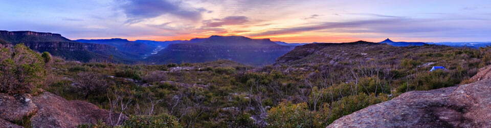
With rain forecast for later in the day we were packed up and walking around 8:00am. Starting from the picnic area near Troy Walls Lookout we headed west for several hundred metres before turning north as the track heads sharply downhill towards Bungonia Gorge following Bretons Creek. This is a very scenic descent at this time of the year with plenty of flowering plants in full bloom. A very impressive stand of grass trees is found about half way down creating an impressive foreground for the view to the west of the cliffs towards Adams Lookout.
Max elevation: 568 m
Total climbing: 3251 m
Total descent: -3251 m
Average speed: 8.51 km/h
Total time: 04:31:48
Once down into the canyon there are Impressive views in both directions. At first the walking is easy along open sandy and gravelly tree lined creek bed, without sections of open water. As you move deeper into The Slot Canyon the walls each side become more imposing and the easy walking disappears completely. You are now confronted with a giant maze which must be solved in order to progress, giant boulders filling the canyon from side to side. Some you walk over, some around and some under. More than once we found ourselves backtracking, looking for alternatives to dead ends or big drops onto more boulders below. A lot of fun, but you must be patient and comfortable jumping from rock to rock and doing a bit of route-finding and scrambling.

View along Bungonia Gorge
Once clear of the boulder field the challenges diminish but you still need to find the track out! With the warning signs at the start of the walk – for fit, experienced hikers only, off track walking, etc. we kept a very close lookout for signs of track to our right (south). Coming out of a couple of days of offtrack walking in The Budawangs just days before we were confident enough. We also had the track marked on our GPS. Didn’t find the first marked track, then found a tree that looked like it had yellow paint on it (or was that old moss or similar?) which we quickly discounted. A bit further along we located a rough track, exactly matching the indicated position on our map, so off we headed up the hill. All sign of the track disappeared after 20m but undeterred we continued on knowing we were in the right spot and thinking we would be certain to relocate the track proper very soon. Anyway, about 300m vertical metres later we did! My old series topographic map was showing an old, now non-existent earlier route of the track. It now heads up a longer, more gradual ridge another 500m odd metres along Bungonia Creek from where we had left it. Our version was steep, with lots of loose rocks and dodgy footing on open hillside. We climbed a couple of hundred metres before entering shrubs and trees. It was good, adventurous “shortcut” but is not recommended.
Once back on the Red Track proper the route is blindingly obvious. I’m certain there must be very adequate markings where it leaves Bungonia Creek, National Parks wouldn’t want people getting lost after all!
Clickable icons on a world map which open the related trip report
A detailed, searchable trip list with links to reports, photo galleries and other content
![]()