11/09/2020 – 13/09/2020 Long Gully – Castle Gap – Clyde River – Byangee Mountain
Morton National Park, NSW
Yuin country
Distance: 34km Total Ascent: 1210m Total Descent: 1210m Time: 15 hours
Participants: Stephen Davies (Photos, Report), Sue Davies
I have been wanting to do a trip into the Clyde River – Holland Gorge area for many years. It must be about 40 years since I was in the area and then only briefly whilst crossing from north to south, Folly Point and across to Monolith Valley and Mount Tarn in the 1980s. With major bushfires burning through the region last summer I thought there might be less scrub bashing than in recent years.

Day 1: Friday 11/09/2020 Long Gully – Castle Gap – Clyde River near Tinga Clearing
Max elevation: 484 m
Total climbing: 2287 m
Total descent: -2278 m
Average speed: 3.78 km/h
Total time: 05:16:32
We arrived in Long Gully after driving from home early and were ready to walk by 10:00am after a scare at Yaboro Campground which was displaying and road closed sign across our route. It was a short washed out section, easily detoured around through the campsite.
We walked to and across Yaboro River in our crocs, the water level seemed a little lower and the water not as cold as expected. Boots and gaiters on, we headed up Byangee Trail in clear, calm and very warm weather along the way admiring the amount of regrowth and resilience displayed by the native vegetation. There was a lot more green than we had expected, shoots the full height of many trees and plenty of emerging plants greening up the ground.
The route after reaching the cliff line to Castle Gap seemed more unfamiliar than we had expected, having done it about eight times in the last 15 years. We found ourselves “off track” much more than usual, a combination of fallen trees, the loss of smaller shrubs, washouts and debris from heavy rain about a month ago we suspected. This time we skipped Cathedral Cave and Natural Arch and passed across Castle Gap before taking a lunch break under Byangee Mountain.
Continuing about 500m around Byangee Mountain base we tried to pick up the ridge that leads down to Clyde River. With the benefit of hindsight, I wouldn’t have cut the corner to get onto it. The very steep first 200m crosshill descent didn’t provide much in the way of reliable footing. Lots of rocks tumbling downhill after being disturbed, we were lucky neither of us followed! Once onto the ridge proper and off the steep upper section we were able to make much better progress, although slowed by a lot more regrowth than expected.
We thought we had it all done once we sighted the Clyde River just below. However, edging closer the final hundred metres looked too steep and heavily vegetated to descend safely. It was no better heading towards the Cooyoyo Creek junction, so we backtracked in the opposite direction and followed the top of the next ridge gently, all the way down to the river.
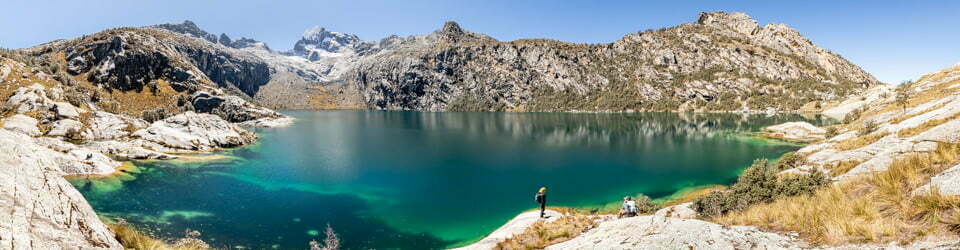
Reflections in Clyde River near Tinga Clearing
Now needing to cool down we found a nice sandy spot for our tent and set up camp and had a bath in the river before enjoying the afternoon sun in very calm conditions.
Day 2: Saturday 12/09/2020 Tinga Clearing – Clyde River
Max elevation: 129 m
Total climbing: 292 m
Total descent: -291 m
Average speed: 2.66 km/h
Total time: 03:06:10
AIt was a nice cool, clear night with plenty of stars popping in and out of view from behind the regenerating forest. Attempts at a timelapse were abandoned as I was unable to prevent dew build up on my lens with my gerry-rigged mini-computer fan, back to the drawing board.
We were up with the arrival of daylight at 6:00am but had a two hour wait for the rays of the sun to reach camp from over Warre Head just before 8:00am by which time we were almost ready to continue our walk upstream.
It wasn’t very long into our day before it became obvious the post-fire regrowth at ground level was doing really well. Away from the sandy, stony river bed and banks the soil was covered in a thick carpet of lush green regrowth of grasses and weed-like plants up to and over head height in several stands. The ground itself and whatever hazards there might have been there were not visible at all. We were lucky to spot a number of deep stump holes but not some of the numerous trip hazards as we negotiated our path around fallen, blackened trees.
Solid regrowth along Clyde River
Further along after crossing to the eastern side, heading for the less steep side we were forced to climb but were unable to navigate a route back to the river-side down a very steep hill which was not hinted at on my topographic map. Our only option became clear as we headed back towards the river trying to remain on the eastern side, we would have to repeat our previous awkward crossing on the steep, opposite bank through a pile of flood debris and collapsing sand.
Trying to continue onward, now on the western side, it became increasingly obvious it wasn’t going to get any easier and as we considered it to be potentially too dangerous, especially for a party of two, so we decided to abandon our target of reaching the Holland Creek junction and return the way we had come. The 6km travelled in three hours by our return to last night’s campsite would have to satisfy us for the day.
The rest of the day was spent re-establishing camp, this time with the tarp put up to provide some shade and an enjoying a calm “beach” day in the afternoon sun by the Clyde. With the temperature in the mid 20’s, our afternoon dip was most welcome and very refreshing.
Day 3: Sunday 13/09/2020 Tinga Clearing – Byangee Mountain
Max elevation: 511 m
Total climbing: 3245 m
Total descent: -3254 m
Average speed: 5.41 km/h
Total time: 06:52:37
We managed an early enough departure from camp, again with fantastic weather. The charred remains of tall eucalyptus trees around and above our campsite had remained intact during our stay, ensuring our overnight survival. They, with all of their epicormic shoots, are pleasing evidence of the resilience of the Australian bush.
As now expected the first hundred metres or so above camp involved pushing through a lot of lush green regrowth which obscured the ground beneath our feet. Moving up the ridge as the soil became drier, thinner and rockier the ground became much clearer and the selection of foot placement an option as demanded by visible hazards. Keeping to the top of the ridge we found a lot of small flowers and colourful orchids, along with hollowed-out trunk trees resulting from the fire. With fallen trees and remaining stands of burnt and skeletal bushes, we needed to pick our way along our desired bearing. Near the top, now the forest canopy was thin, there were fantastic views over towards The Castle. During the ridge ascent, the clouds and wind had arrived along with a couple of sprinkles of rain.
As we approached the cliff-line of Byangee Mountain we made sure we remained on the very top of the ridge, as it was highly undesirable to return via the steep, loose surfaced short-cut we had taken coming down. This indeed proved to be much easier, with sure footing to the cliff, we also noted there was a rock cairn to mark the spot!
Just around the corner from here is the gully for the Byangee summit ascent marked with bright pink rope. After making our way up to the boulder blockage and struggling to lift my 20kg past it, we decided to leave our packs and investigate the water supply available on top, before our planned two-night camp and summit plateau exploration (this plan emerged late yesterday after we had abandoned our Clyde River exploration). Without the added burden of packs our pace picked up and we reached the summit in good time. It should be noted that there are two new ropes along the climb, a thinnish one at the boulder and a longer climbing rope up the gully just past it, these are both obviously post-fire additions.
On top the wind was gusting to very strong, pushing me off balance a couple of times. With heavy cloud cover and a couple of drops of rain we sought out the usual deep depression in the sandstone tops for our water supply, we found half a dozen with shallow pools, too shallow to retrieve much clean water. A quick walk to the far side for the views and a phone check in for the weather forecast had us leaning towards not making the effort to camp on top. Most prominent in the decision was the wind, followed by a lack of access to water, then the dull lighting created by the heavy cloud cover.
On our return down we were forced to do a bit off waiting, for the first time since leaving the car we encountered other people, in this case, a group of 17 from Dapto down for a day trip. Once we got past the oncoming traffic and retrieved our packs we quickly completed the down climb before walking around and sitting under an overhang for lunch.
On our return we checked out The Arch (the little tree right beside it is intact) and further along “The Cathedral” which although burnt, was looking almost back to normal from inside looking out.
“The Cathedral” below The Castle
With some more careful observations and by remaining closer to the cliff-line on the way back we avoided a few of the down-and-around detours we had made on the way in, much to our satisfaction. Our steady descent of the fire trail had us back to the car by 4:00pm and on the road home shortly after. Although we had not completed our original objectives and were heading out two days early we were happy with what we had done and to arrive home safely.
Clickable icons on a world map which open the related trip report
A detailed, searchable trip list with links to reports, photo galleries and other content
![]()