
Thursday 15/10/2020 Gemini Loop Road – Snow Gums Walking Track – Cattle Creek Hut – Breeza Lookout – Jemmys Creek Fire Trail – Shepherds Peak
Coolah Tops National Park, NSW
Kamilaroi country
Participants: Stephen Davies (Photos), Sue Davies (Report), Trish Law, Dave Whitelaw
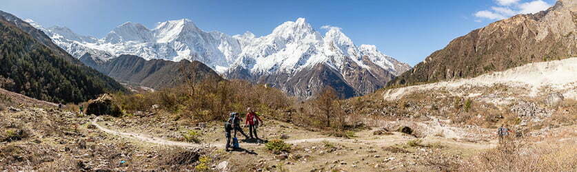
From our camp at Bracken’s Hut we drove east along Forest Road. NSW National Parks recommend the use of four wheel drives and advise against driving it in wet conditions as it is a rutted gravel road. It was slow progress in our Forester. Whilst out this eastern side of the park we completed two different walks, the first a circuit to the world’s biggest known snow gum and Cattle Creek Hut. The second along Jemmys Creek Fire Trail to Shepherds Peak Lookout and return.
Gemini Loop Road – Snow Gums Walking Track – Cattle Creek Hut
Max elevation: 1159 m
Total climbing: 100 m
Total descent: -100 m
Average speed: 4.41 km/h
Total time: 01:24:46
Parking at the beginning of Gemini Creek Road we headed down it for a short distance before turning off onto the Snow Gums Walking Trail. This short forest walk leads you to a view of the largest snow gum in the world, here they can grow to 40m in height. These lofty, grey coloured bark snow gums look very different to their much smaller, gnarly, often very colourful relatives found in Kosciuszko National Park. After completing the Snow Gum Walking Track circuit we were back on the fire trail for a short walk to the rustic Cattle Creek Hut. This is set in a delightful location in the forest alongside a small creek. Here we spent a few minutes watching emerging circadas being eaten by ants, debating whether to mount a rescue or not and quickly decided not to interfere in a perfectly natural event.

Cicada at Cattle Creek
NSW National Parks signage along this track also states
“SNOW GUM WALK
Easy 1.2km return Grade 3 Time 45 minutes
This short walk leads to the largest known snow gums in the park. Their exquisite bark is at its colourful best after rain.
The Giant Snow Gums Of Coolah Tops
In south-eastern Australia, Snow Gums (Eucalyptus pauciflora) grow at altitudes of up to 2000 metres. They occur in many habitats such as mountain slopes, exposed ridge tops and tablelands, as well as plains at lower altitudes and are commonly found on shallow rocky soils as well as moderate quality, well-drained alluviums.
The white flowers of the Snow Gum can be seen from October to January and the tree can be easily identified by the unusual length of its leaves which may be up to 18cm long.
The average altitude on the plateau of Coolah Tops is about 1100 metres, which is high enough to receive regular snowfalls.
A Forest Giant
This giant Snow Gum (Eucalyptus pauciflora) measures 4.3 metres around the trunk and its canopy reaches to over 32 metres. Giant old trees like this provide many hollows where gliders, possums and birds can shelter and nest. Species such as Powerful Owls will only nest in hollows that are about 50 – 180cm deep and over 12m above the ground. Some eucalypt trees may take 150 years to develop large enough hollows. Young, regenerating forests lack old trees with suitable hollows for nesting.
Here in Coolah Tops, the conservation of many rare and endangered forest species is utterly dependent upon the preservation of the old habitat trees.
Meet A World Record Holder Snow Gum
Elsewhere in Australia, the Snow Gum (Eucalyptus pauciflora) is commonly a straggly, twisted small tree of alpine areas, stunted by strong winds, heavy snowfalls and shallow soils. But here in Coolah Tops the trees reach to 40m and are the tallest known Snow Gums in the world.
The scientific name paucus means few and florus means flowered, which is not really appropriate as this species often flowers profusely.
Its bark is grey and cream in colour and mostly smooth although it may be rough or ribbony at the base of large trees. Sometimes the trunk may be conspicuously marked by ‘scribbles’ caused by burrowing insect larvae.
The Cattle Creek Huts
These huts, built beside Cattle Creek, stand as silent reminders of a by-gone era when small gangs of timber cutters spent weeks at a time working and living in the forest with only the most basic of comforts.
These men were largely self taught, not just at tree felling and sleeper cutting, but in all the art of forest work including road construction, grading, dozer operation and bush carpentry.
The timber weatherboard hut was built in 1956 and became home to John Driscoll, Tim Scales, Bill Brady, Ray Proctor, Don O’Brien and many others.
Stanley ‘Snow’ Pengilly and Paddy Higgins reputedly built the smaller corrugated iron hut in a single day in March 1963. They used second hand iron sheets, green saplings from the forest and hessian bags for the door. Snow was an accomplished camp oven cook and used this hut as the cookhouse for the timber getters as well as his residence.
Both huts have gone through periods of collapse, vandalism and re-construction. The National Parks and Wildlife Service undertook the most recent restoration in May 2001.”
Breeza Lookout – Jemmys Creek Fire Trail – Shepherds Peak
Max elevation: 1178 m
Total climbing: 269 m
Total descent: -269 m
Average speed: 3.78 km/h
Total time: 01:33:40
Returning to the car we continued along The Forest Road to Breeza Lookout where we stopped for lunch in the shade at the ‘picnic” table provided. A short walk through open forest along Jemmys Creek Fire Trail, an old logging road, led us towards Shepherds Peak.
Along the open forest floor we passed many wildflowers, a benefit of walking at this time of year.
A couple of hundred metres before Shepherds Peak, on the edge of the ridge to the left of the trail, we encountered a number of Musk Lorikeets and butterflys feeding on very impressive bunch of tall, flowering grass trees. The Musk Lorikeet (Glossopsitta concinna) displayed great agility in their efforts to reach the tastiest morsels, whilst if you looked much more closely you could also see a couple of different species of butteries getting their fill as well. Later one pair of the Musk Lorikeets decided it was the time and place for a mating session.

Musk Lorikeet (Glossopsitta concinna) in Grass Tree
Past the grass trees as you reach Shepherds Peak there is a short scrambling section to negotiate before walking out onto Breeza Lookout. From here there are sweeping views of the Breeza Plains to the north.
Once back to the car we had the rough, 45 minute, 24km return drive to Bracken’s Hut to complete. There another lazy afternoon was spent watching the Eastern Grey Kangaroos grazing nearby and after dark the star filled sky.
Timelapse at Brackens Hut
Timelapse at Joes Hut
NSW National Parks signage along this track also states
“Breeza Lookout
Located in the undisturbed far south-east of the park, this lookout opens out across the expanse of the Breeza Plain with its charming patchwork of agricultural land.
Shepherds Peak Walk
Moderate – Steep 3km return Grade 3 Time 1 – 1 /12 hours
From Breeza Lookout walkers may wish to explore the basalt dome jutting out of the escarpment. The last section is a short but challenging scramble suitable for fit and experienced walkers only.
Black cracking clays
From the lookouts here at Coolah Tops, you can see the vast agricultural lands of the Liverpool and Breeza plains. The soils were deposited by a network of rivers (alluvial soils) and the eroding lava fields.
The combination of deep alluvial soils known as ‘black cracking clays’ on the plains, with slopes enriched by minerals eroding from the surrounding volcanic landscape, equates to some of the most productive agricultural land in Australia.
Coolah Tops
Coolah Tops is part of the largest lava field in NSW (6,000 square kilometres). It is the result of the opening up of the Tasman Sea between Australia and New Zealand. The volcanic activity around Coolah Tops occurred between 40-32 million years ago, at least 14 million years before the nearby Warrumbungle Volcano began to form.
A lava landscape Coolah Tops is a high plateau of basalt (approximately 1,000 metres above sea level) at the junction of the Liverpool and Warrumbungle ranges. It is part of the eroded remains of a lava field.
Lava fields do not have a central volcanic vent but erupt from multiple fissures. The lava that oozed and spewed from the vents in this area covered 6,000 square kilometres. It cooled to form a thick layer of basalt. In some places the basalt is 1,000 metres thick.
Caves have formed in some of the basalt flows in the park. It wasn’t the usual type of basalt though. The caves formed in basalt rich in gaseous water and carbon dioxide.
As the gas was released, holes in the basalt were left behind. The holes were later filled with a whitish mineral called ‘zeolite’ carried there by groundwater.
Zeolite is very soft and once exposed to wind and water it erodes and sometimes forms caves.
Bracken’s Hut
Bill Bracken lived in this hut for no less than 11 years into the late 1940’s with his wife and three children. The Bracken’s kept a small herd of jersey cows for milk and meat. They also kept a bull and chickens.
Following Bill Bracken, Jack Breen and his wife lived here for a few years in the early 1950’s. From this time on the hut was not permanently occupied, however, it was used for weeks at a time when mustering took place or fencing was being completed.
By 1996 the hut was suffering badly from years of neglect and vandalism which prompted the National Parks and Wildlife Service to undertake a program of restoration and maintenance. Using handcrafted timber, bush carpentry techniques and second hand materials the aim was to return the hut to (as close as possible) its original state. The restoration was completed in March 1999.”
Friday 16/10/2020
I enjoyed an early morning run along the fire trail to Howard Springs Farm and the road leading to Bracken’s Hut. My only company was a few wallabies.
While packing up for our departure I saw the resident red bellied black snake on the path to the toilet. He soon slide away and found refuge amongst the tussocks surrounding the hut.
Clickable icons on a world map which open the related trip report
A detailed, searchable trip list with links to reports, photo galleries and other content
![]()
Good post thank you
John Driscoll was my cousin. His father, Paddy, lived at Edenvale at the base of Coolah Tops at the end of Pembroke Road.