
9/06/2022 – 18/06/2022 Kiandra – Pollocks Creek – Selwyn – Tabletop Mountain – Tabletop Mountain Trail South – Arsenic Ridge – Arsenic Creek – Happy Jacks Road – Tibeaudo Creek – Boobee Hut – Diggers Creek (Northern Tributary) – Doubtful Gap – Doubtful Gap Trail – Doubtful Creek – Cesjacks Hut – Doubtful Creek – Macalister Saddle – Toolong Range – Geehi River – Tarn Bluff – Mailbox Hill – Cup and Saucer – Brassy Mountains – Valentine Creek – Tin Hut – Valentine Creek – Gungartan Pass – Dicky Cooper Creek – Schlink Pass Road – Schlink Pass – The Rolling Ground – Whites River Hut – Munyang River – The Rolling Ground – The Granite Peaks – Guthega Trig Spur – Guthega Dam – Farm Creek – Illawong Walk – Snowy River – Spencers Creek Suspension Bridge – Mount Guthrie – Snowy River – Charlotte Pass – Summit Walk – Snowy River Pole-line – Kosciuszko Walk – Kosciuszko Express – Thredbo
Kosciuszko National Park, NSW
Ngarigo Country
Distance: 120km Total Ascent: 4500m Total Descent: 4000m Time: 51 hours
Participants: Damien Aggio, Stephen Davies (Photos, Report)
Following excellent snowfalls in early June, Damien saw an opportunity present itself for an extended backcountry ski trip. The classic K to K (Kiandra to Mount Kosciuszko) over 11 days, including car shuffle, was proposed. He promptly made a few phone calls and posted his trip on the New South Wales Nordic Ski Club website to gauge interest.
After two very CoVid 19 disrupted previous seasons I jumped at the opportunity to join in after last attempting this trip, solo, in 1986 when I was forced to finish early via Guthega Power Station due to cold, windy, whiteout conditions.
Day 1: Thursday 9/06/2022 Kiandra – Pollocks Creek – Selwyn
Max elevation: 1555 m
Total climbing: 168 m
Total descent: -14 m
Average speed: 2.82 km/h
Total time: 01:30:48
I started at home from where Damien picked me up. We were away around 7:30am, driving his vehicle to Kiandra from where we planned to start our 10-day expedition. After several recent snowfalls, the snow cover was fantastic for early June. We were hoping to reach Mount Kosciuszko and exit at Thredbo. At Kiandra, there were no opportunities to park off the road until we reached the ruins at Kiandra Courthouse where the snow plough had cleared a small area. As luck would have it, just as we were deciding where to park a snow plough arrived, Damien jumped out of the car for a chat with the driver who then volunteered to clear all the snow off a spot, just for us.

Damien amongst burnt trees between Kiandra and Selwyn
As we headed off, it was snowing lightly and we had one hundred percent low cloud cover. With very heavy packs now on our backs (mine was about 27kg) we took our time as we climbed straight up the first 120m hill. Along the way observing a lot of rabbits running across the snow, along with their dirty burrow entrances. Around 1km in we also saw a very small animal making tracks as it scurried across the snow, maybe an antechinus.
The snow itself was surprisingly deep, there were even several small cornices that had formed. Sticking roughly to our bearing of 220 degrees we slowly worked our way through a lot of burnt trees.
With about 30 minutes to sunset, the lighting had become very flat, making it hard to see each other’s tracks. We decided against pushing through under torchlight to Broken Dam Hut and set up camp barely 3km from the car amongst the dead trees. The light breeze and snow flurries continued on into the night.
Day 2: Friday 10/6/2022 Mount Selwyn – Tabletop Trail – Mount Tabletop
Max elevation: 1691 m
Total climbing: 522 m
Total descent: -388 m
Average speed: 3.69 km/h
Total time: 06:39:27
We had a steady stream of snow showers overnight as temperatures remained just below zero and winds of around 10km/h regularly punctuated the night.
With low cloud cover and light snow showers persisting throughout the day, we had very limited views and poor visibility. We were however blessed with around a metre of snow which was much better consolidated than we had expected. Our skis didn’t stick or ball up and they ran pretty well, mostly without sinking more than a couple of centimetres.
We felt as if we were travelling through an alien landscape all day due to the 2019-2020 bushfires, as with all the snow, low cloud cover and burnt trees it was virtually a black and white day. Thank goodness for our colourful clothing and ski gear!

Ghostl;y gums near Four Mile Trail Junction
Up to lunchtime, we sighted at least six small mice scurrying across the snow, ducking and weaving their way between trees and any depressions in the snow. At lunchtime, as we sat on our packs one spent some time checking out what was under our boots. Soon after lunch, I took a photo of a crow sitting very still on top of a burnout tree, only to discover on magnifying the photo that it was only the top of a tree.
Navigation was a big issue today, as we only once caught sight of anything more than a couple of hundred metres away. We stopped frequently to verify our current position in relation to where the track was meant to be. We also encountered several places with small snow dunes and cornices barely distinguishable from their surroundings.
On reaching the Broken Dam Hut turnoff, we debated the merits of spending the night there, Damien arguing we could make an earlier start than this morning’s 9:15am effort. In the end, we pushed on in order to gain a few more kilometres. We also took into consideration that with the number of mice we had seen so far it would be likely that we would have their company in the hut.
We pulled up just on 4:00pm, wanting to get the tents up before dark. We ended up pitching them on a flat section of the track below Tabletop Mountain from where we had two bars of 4G Telstra reception. With snow flurries continuing we were not long out of our tents.
Damien Added: One day after commencing our 10 day trip, I thought to check the National Parks website for alerts. There I found that Happy Jacks Plain was to be closed for aerial culling immediately after the June long weekend. This gave us only one day spare to cross in time.
Day 3: Saturday 11/06/2022 Tabletop Mountain – Tabletop Mountain Trail South – Arsenic Ridge – Arsenic Creek – Happy Jacks Road – Tibeaudo Creek – Boobee Hut
Max elevation: 1715 m
Total climbing: 566 m
Total descent: -752 m
Average speed: 4.03 km/h
Total time: 08:32:41
After a sound sleep with the occasional gentle gust of wind and snow flurries, I awoke at sunrise to catch some great colour in the sky and views as the clouds had briefly lifted around us. Still, despite our best efforts, we didn’t depart camp until about 9:30am. We both commented on how fantastic the cover and continuing snow flurries were making the skiing.

Sunrise from Tabletop Mountain
We continued south along Tabletop Mountain Trail South with the visibility now down to a couple of hundred metres at the most and extremely flat lighting. I benefited a lot by following Damien’s tracks and was glad he didn’t think it follow mine!
We turned west at the trail junction where we found some trail signposts. Along this section, the lighting was particularly poor in places. Twice within 20m, I failed to see wind ridges just metres ahead, resulting in two falls. Getting back upright with a 27kg backpack on whilst sinking into the snow proved very close to the limit of my strength. I should have continued to follow Damien!
About 600m past the signposts we headed off track, not that there was any evidence we had been on one, aiming to descend towards Arsenic Creek via Arsenic Ridge.
The trees were thick on the first half of this route but it opened up a lot and became less steep on the lower half. I found it too difficult at times under the weight of my pack to complete telemark turns amongst so many trees, I was just not strong enough to support the combined weight and forces of the turn. This resulted in four falls and a huge expenditure of effort getting back up off the snow. Damien, on the other hand, managed the descent easily. Was it better technique, lighter pack weight, age advantage, wider skis with more sidecut or the fact that he parallel turns?
Once down to Arsenic Creek we had continuous snow cover up to Happy Jacks Road. Along Arsenic Creek we sighted a kangaroo hopping through the snow, a nearly dead mouse and his friend, and four rabbits. There was a significant build-up of cornices along the western side of Arsenic Creek and a thin snow cover over the creek flats. We had by far the best weather of the day along Arsenic Creek.

Hypothermic mouse near Arsenic Creek
We arrived spot on at the concrete bridge at the confluence of Arsenic Creek and Happy Jacks Creek and hit our first short, snow-free section over the bridge. Once across we took a diagonal route for the short climb to Happy Jacks Road.
The weather had taken a turn for the worse with the return of continuous low cloud cover, limited visibility and a very strong, cold headwind. The road itself began a deterioration in the quality of the snow cover and weather. The sun road had a few bare patches, icy sections, very thin leads of fresh windblown snow as well as several almost impossible-to-see gullies running right across the road, greatly slowing our progress.
As Damien had his sights set on Boobee Hut for the night, we were in for a slog to finish the day. We had a very cold, strong headwind, it approaching sunset and we still had another 7km to go. I checked the map out and decided that we could take 2km off that 7km if we headed up along the ridge straight after crossing Tibeaudo Creek.
Not long after on the ridge the light was failing quickly and we still had 3km to go, at around the same time, lack of traction forced us to put skins on. Between the skins, some climbing, the failing light, navigation checks and strengthening headwind with snow flurries the going was very slow. The headlamps went on about 1.5km from the hut, Damien was easy to pick as his headlamp flashed. Tiring a lot towards the end of a long and varied day we were very glad to find the hut, in darkness at about 6:30pm.
There was a 40cm step down into the hut due to the build-up of snow, here I almost fell in as the snow gave way on entry. We were very pleased to be out of the wind and have the hut all to ourselves for the night.
Day 4: Sunday 12/06/2022 Boobee Hut – Diggers Creek (Northern Tributary) – Doubtful Gap – Doubtful Gap Trail – Doubtful Creek (at 1550m)
Max elevation: 1619 m
Total climbing: 329 m
Total descent: -298 m
Average speed: 3.48 km/h
Total time: 04:32:10
After a big day with a late finish yesterday, we were happy to sleep in and didn’t depart until around 10:30am, aiming for O’Keefes Hut. There was plenty of wind about last night so we were very glad to have spent the night in Boobee Hut, the first visitors since the snow arrived about two weeks ago. This rebuilt edition of Boobee Hut was most comfortable and is very well sealed so there were no draughts. It boasts some roof insulation and a wood-fired stove among its features.
From the hut, we headed down below the trees and followed the valley of the northern branch of Diggers Creek to Doubtful Gap. With plenty of snow around there were only the occasional tops of grasses poking through. The snow was smooth, firm and fresh, and the gradient very gentle and entirely out of the trees, making the skiing delightful. As the sky was again covered in low clouds there were no views, thus forcing us to continue wearing our yellow lensed goggles for the fourth straight day.
We had an early lunch just below Doubtful Gap to keep out of the wind. After lunch, we used GPS positioning to confirm we had reached Doubtful Gap Trail before heading along the trail to the south. This required several more GPS checks to confirm the position of the track, which in many places was far from obvious. Our worst skiing of the day occurred along the track where it meanders through the trees. There were many snow ridges across the road on the lee side of trees and they were extremely difficult to spot with the flat lighting.
Along the next section, we surprised two large wild pigs rooting around, causing great damage to the plant life, ripping it from the soil and digging around underneath it. The first was trackside at the base of a tree near Doubtful Gap and the second on open ground further along.
Damien added “The trail rose to a peak above Doubtful Gap, soon followed by a significant descent with many snow ridges and ruts across the path. We decided at this point to temporarily swap rucksacks, matching up the heaviest pack to the skier equipped with the best skis for downhill. This worked a treat and surprisingly there were no more falls experienced.”
There is a small sign at the junction of the Australian Alps Walking Track and Doubtful Gap Trail. From here we headed south-west “along” the AAWT as best we could guess towards the ford across Doubtful Creek. Here, there is a steep descent in the last 50m to be aware of. Along Doubtful Creek the snow was banked high on both banks to almost 2m above water level, at the crossing we guessed the water to be thigh to waist deep with strong flow. Every rock we saw was covered in what appeared to be brown algae. On some recent walks in ankle-deep water with similar slim-covered rocks, I found it to be about as slippery as ice. The base of the river has many large angular rocks, some of which I thought may have been stepping stones but these were underwater. After checking a few nearby options we decided O’Keefes Hut would have to wait for another trip, so began heading upstream along the true right bank of Doubtful Creek towards Cesjacks Hut as our revised destination.

Damien skiing along Doubtful Creek
Around 1km upstream there was a nice level spot where Damien suggested we camp for the night. After yesterday’s late finish the deal was done. So at 3:00pm we were preparing camp.
Soon after sunset, there were a few small breaks in the clouds allowing us to view the full moon through the trees above our camp.
Day 5: Monday 13/6/2022 Doubtful Creek – Cesjacks Hut
Max elevation: 1718 m
Total climbing: 429 m
Total descent: -262 m
Average speed: 2.54 km/h
Total time: 04:11:15
The clouds had completely disappeared by the time we woke up and overnight the snow had hardened up a lot and had a thick layer of frost above. As we prepared to leave we watched the shadows shorten on the slopes across Doubtful Creek. We were very happy when we got our first full sun an hour or so later.
As usual, we took ages packing to leave and didn’t get away from camp until after 10:00am. We were hoping to get through to Cesjacks Hut by lunchtime and were contemplating a side trip to Jagungal, maybe under moonlight.
We both left camp with our skins on our skis as the hard snow wasn’t offering much grip and we had a few slopes to traverse as we followed Doubtful Creek upstream. As Damien had short skis with more side cut than mine they were not offering as much bight traversing across the slope. At one point on a particularly steep side incline, he came unstuck and began accelerating downhill towards the river. Fortunately, a small tree arrested his slide.
It appeared his binding had failed as he slipped whilst traversing, the front part pulling completely off his ski. His detached ski and binding also managed to stay out of the water. This was really unfortunate and lucky at the same time, we both thought the lucky far out-wayed the possible alternatives.
Damien managed to collect his gear and walk to a nearby flat bit of ground so we could consider our options. He found walking was mostly easy but after occasionally falling full leg length through the snow it was not an option. After some thought, using Damien’s snow claw and some thin cord I had, Damien fashioned a snowshoe. It was quite a sight watching him as he continued, one leg on a snowshoe and the other on a ski. At least he was able to make forward progress.

Damien’s modified skiing technique
We continued to Cesjacks Hut hoping to maybe catch another party, perhaps with some tools or items that may assist with repairs or provide assistance in leaving via Nimmo Plain. We arrived at about 1:30pm to find no ski tracks in sight and discovered the last entry in the logbook to be 22nd May. We were on our own.
Damien spent several hours considering all of the items we had that might help. Eventually, he made use of some fencing wire, a couple of cable ties, a scrap of plastic from the hut and some gaffer tape to fashion his repair. Once finished he felt confident he could continue but with somewhat limited efficiency and capacity. Tomorrow will tell.
It was an interesting sunset with the full moon rising just above some incoming fog. A little earlier I had watched clouds flowing across the hills to the north-west. We had one bar of Telstra reception outside the hut so I was able to inform our contacts of our current situation. I also noted later that I only got usable phone reception if I was facing the full moon!
Around dinner time we heard a tapping outside, there in the window was a possum with its nose to the glass, checking us out. Unfortunately, its visit was too brief to capture a photo. By bedtime, all the clouds and fog had dispersed and there we great views of the stars.
Day 6: Tuesday 14/06/2022 Cesjacks Hut – Doubtful Creek – Macalister Saddle – Toolong Range – Geehi River – Tarn Bluff – Mailbox Hill – Cup and Saucer – Brassy Mountains – Valentine Creek – Tin Hut
Max elevation: 1889 m
Total climbing: 536 m
Total descent: -399 m
Average speed: 3.75 km/h
Total time: 07:34:06

Misty dusk from Cesjacks Hut
More gear failures overnight. Unfortunately for me, I couldn’t do my sleeping bag zipper up last night and with a little freezing occurring in our water bottles it was obviously a cold night inside the hut. I didn’t find it to be too cold as I wore all my clothes and tried to keep the open edges of the bag firmly tucked underneath my body. In the light of day, I closed the zipper runner gap ever so slightly with an axe (not any other tools to pick from here!) and the zipper worked again first go. I’m not sure how long that will last.

Ski repairs at Cesjack Hut
We departed the hut at about 10:00am not sure how well Damien’s repair would work. Damien wisely took his time on the descent back down to Doubtful Creek, trying to get a feel for his highly modified ski. He described it as very challenging as the repair was tending to shudder and act as a brake. It was looking like no more parallel turns for Damien on this trip.
We were very fortunate with the weather this morning, getting some nice colour on the surrounding hills as the sun rose. There was barely a cloud in sight. There was however a very chilly breeze that popped up from time to time during the day, forcing the addition and removal of layers of clothing several times.
Once on the gentle upstream ascent along Doubtful Creek, Damien began to adjust his technique to his damaged ski and was able to keep up a pretty good pace, not too much slower than normal. As we approached Macalister Saddle we encountered a sounder of seven wild pigs not far away, they seemed relatively unperturbed by our presence, wandering around as they pleased. Shortly after a lone piglet sighted us and hurried over towards us to check us out, stopping about 15m away for its inspection.

Inquisitive piglet near upper Doubtful Creek
We stopped on Macalister Saddle for lunch before heading off again towards Tarn Bluff along the headwaters of the Geehi River. We carefully selected our route, trying to avoid icy sections and uneven ground in an effort to keep Damien’s repair intact. Where we could, we kept to the lee side of hills where we could ski through long runs of nicer windblown snow deposits
We kept our route along the Brassy Mountains well above Valentine Creek and managed a gentle traverse towards the saddle above Tin Hut after sunset. By this time the breeze had picked up again and it was very cold, forcing another stop to add more layers of clothing. The final hour into Tin Hut had us expecting we might have our first company for the trip, as we had found the tracks of a lone snowshoer heading that way. As the sun set behind us we felt alive as we witnessed a range of changes in light and colour. Half an hour out from Tin Hut we saw a brilliantly bright full moon pop up over the top of the Brassy Mountains, almost startling us as it did.
Approaching Tin Hut we saw no lights on, the snow-shoer was not there. We did, however, sight the first ski tracks we had seen the whole trip. Tin Hut obviously had some other visitors not long before our arrival.
By day’s end, we were both very pleased with the day’s progress, as Damien’s repair had held up well, a credit to his ingenuity. The question now is, is it worth the risk of attempting to complete the trip across the Main Range with broken gear.
Day 7: Wednesday 15/06/2022 Tin Hut – Valentine Creek – Gungartan Pass – Dicky Cooper Creek – Schlink Pass Road – Schlink Pass – The Rolling Ground – Whites River Hut
Max elevation: 1994 m
Total climbing: 557 m
Total descent: -701 m
Average speed: 3.73 km/h
Total time: 05:15:56
Again, after a big day with a late finish yesterday, we took our time to get going. I was up for a few predawn photos trying to catch some colour and Damien wasn’t far behind. We noticed a very cute antechinus make numerous visits via a gap below the door as we were getting ready. It was probably about all night without either of us noticing. It had no fear in getting amongst our gear or under our feet. After initially ushering it outside we gave up as the door was no barrier to it anyway.

Departing Tin Hut
We had the best snow we had ever experienced in our crossing of Gungartan Pass via the headwaters of Valentine Creek, firm and mostly topped with a veneer of soft snow. There was, however, a very cool breeze despite the mostly clear sky. Progress was very good, despite Damien’s damaged ski. Even the descent from Gangartan Pass offered a lot of decent snow and a few turns amongst small patches of wind-blown rubbish.
Around the northern end of the ridge below Gungartan we turned to the south-west to ski down the valley of Dicky Cooper Creek which meets Schlink Pass Road about 400m below Schlink Pass. We found a spot about 200 metres before the road that offered a little shelter from the wind, so stopped there for lunch. Here Damien informed me that he had decided to continue the trip with me to Thredbo as he was now confident his repaired ski was up to the challenge. This was great news!

Damien on Gungartan Pass
After lunch, we completed the short ski down to the road, with Damien trying a couple of turns. Then Damien informed me that he had changed his mind again and he would be exiting down to Guthega Power Station, as he had just observed movement in his binding repair.
After attempting a check-in phone call from Schlink Pass we parted ways. From here, I started to work my way around and up onto The Rolling Ground. I seemed to make this more difficult than it could have been but finally, after putting skins on, found a way up through the plentiful cornices. Now, it became increasingly difficult to evaluate the lay of the land due to a large incoming mass of low clouds and the very flat light it produced.
Once up to the bench below to spine of The Rolling Ground the cloud base descended even further, creating white-out conditions, combined with a cold 50km/h wind it was becoming treacherous. I continued on at a snail’s pace for a couple of kilometres hoping for improved conditions, all the time needing to frequently check my position and onward bearing. As I reached the last creek that runs past Whites River Hut I decided conditions demanded a change in plan, as travelling alone in these conditions was just too hazardous.
Having decided to bail out, I was glad that I would be able to rejoin Damien at Whites River Hut as he was planning a slow exit so we could reconnect at the after of our planned trip so we could complete our car shuffle. Even descending very slowly with the skins still on (to act as brakes) I needed to check each step with a ski pole to make sure there was still ground me, this continued for about 100m vertical my descent. Once amongst the trees, there was a little less cloud and the trees themselves could be used as visual reference points but it was still slow going.
I was somewhat relieved when I got to the hut and quickly set about making myself more comfortable. Damien, however, was not there as I had expected and neither was anyone else. At the hut, the visibility was way better and there was much less wind, a stark contrast to 200m higher up.
I spent another half an hour trying to get my sleeping bag zipper working again, as I had noted it wasn’t working again this morning. It was lucky I came down to the hut as I found a metal handle I could gently hammer away on the zipper until I finally got it working again. I would have had a very cold night in the tent if I had been out camping as planned.
As I think I still have time to complete the trip, I will be carefully looking at conditions in the morning before deciding which way to proceed.
I saw no wildlife today after leaving Tin Hut.
Day 8: Thursday 16/06/2022 Whites River Hut
I was out of the hut at 6:00am for a quick weather check only to find it was raining lightly with the cloud base about 50m above and still a bit windy. I went back to bed, irrationally hoping that it would quickly improve enough to continue towards Thredbo.
Despite my sleeping bag zipper again failing, I kept dozing off to the sound of rain and slabs of snow sliding off the roof as it melted.
Once up I was continually reminded how poor a day it was as rain drops smeared their way down the windows panes and the cloud base lowered. It was a dismal day outside, so proceeding was totally out of the question.
I spent most of the day reading. When I felt I was getting chilled I got up and did some hut cleaning and tidying up.
After 3:00pm I thought I’d top up my water supply and ski up to Schlink Pass to report in and provide an update on my progress. I was surprised, as I hadn’t gone 200m past the hut along the creek when I got some text message notifications. Here I made my call before promptly returning to the hut. My rain gear was all soaking wet by the time I got inside.
More reading ensured, as did another attempt to get my sleeping bag zipper functional. As it was a two-way zipper (close the top and then also open the foot end) I removed the failing runner and changed the orientation of the other one. The bag now closes properly. I am now much more hopeful that the problem is solved for more than a single use.
Day 9: Friday 17/06/2022 Whites River Hut – Munyang River – The Rolling Ground – The Granite Peaks – Guthega Trig Spur – Guthega Dam – Farm Creek – Illawong Walk – Snowy River – Spencers Creek Suspension Bridge – Mount Guthrie
Max elevation: 1970 m
Total climbing: 870 m
Total descent: -904 m
Average speed: 3.92 km/h
Total time: 08:05:31
What a change from last night when I had been resigned to heading out via Guthega Power Station. I awoke to a calm day with crystal clear blue sky.
Deciding I could still reach Thredbo in the two remaining days I hurried the packing and left Whites River Hut by 8:45am. The snow was hard but with a thin layer of hoarfrost on top. I made sure I went up the south branch of Munyang River beside the hut very slowly as it was going to be a long day. The climbing skins and hard snow made this easy enough and I was back on The Rolling Ground one creek head past where I had existed 36 hours previously before I knew it.
Progress along The Rolling Ground was good. In no time I was passing The Granite Peaks and moving through the multiple creek system at the headwaters of “Horse Camp Creek”. Through this section, a cool breeze came and went and there were an increasing number of wind-generated, icy obstacles on the ground. I had anticipated that this frozen surface would soften a little as I progressed but that was not the case. Having made this observation I decided I would not travel any further along the Main Range but instead drop down lower towards the Snowy River via Guthega Trig. As I was nearing Guthega Ridge I saw, in the distance, the first other people of the entire trip, two snowshoes heading up towards Consett Stephen Pass.
As I was heading down the ridge towards Guthega Trig I was very disappointed that there had been no sun softening of the snow. This descent was turning into very hard work, the rain had left lots of regularly spaced speed humps, and trying to ski across these with a heavy pack proved nearly impossible. Although my boots were tightened up to the max the skis were still swinging to and fro about twenty degrees as I crossed each roll. I hit the deck a few times along the way and on one steeper, very firm section I just took the skis off and walked, that was way easier and much safer. With a lunch break halfway down it also took way longer than I had anticipated. I finally crossed Guthega Dam just on 2:00pm.

Granite tors on Guthega East Ridge
From Guthega Dam I took a shortcut across to the Farm Creek Footbridge. Around an hour later, on by far the softest snow of the day, I was passing Illawong Lodge. Around here I noticed two snowshoers on the opposite side of the Snowy River heading further upstream. I was now heading towards Australia’s highest footbridge (recently opened) across Spencers Creek. Here, I ran into the two snowshoers, they were the same two I had seen this morning. They had ignored the Illawong Footbridge, thinking it was too dodgy to use, instead performing a way more dodgy crossing of the Snowy River upstream of Spencers Creek.
From here I continued skiing on soft snow along the side of Mount Guthrie, not far above the Snowy River. At about 5:00pm after the sun had gone down, I found an elevated flat spot with great views back along the Snowy River, it was too good to go past, so In failing light, I set up camp for the last time. It was a glorious, quiet, calm spot. There was some very nice colour over Guthega Dam after sunset.
During the day I hand managed to contact Damien. He had been through Perisher Valley where he had his skis repaired and was on his way to Charlotte Pass where he planned to find a place to camp for the night. Maybe we would catch up tomorrow.
Day 10: Saturday 18/06/2022 Mount Guthrie – Snowy River – Charlotte Pass – Summit Walk – Snowy River Pole-line – Kosciuszko Walk – Kosciuszko Express – Thredbo
Max elevation: 2046 m
Total climbing: 529 m
Total descent: -283 m
Average speed: 3.24 km/h
Total time: 05:26:21
It had been a perfect night. Just a little below zero, completely calm and crystal clear. Being a few days past full moon it was also the darkest evening of the trip, so I finally got to see a bunch of stars.

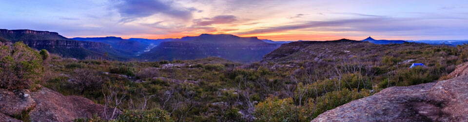
Sunrise view down the Snowy River to Tate East Ridge
Overnight the inside of the tent had turned into a crystal palace. It glistened, starlike, on the arrival of daylight and produced a brief dusting of snow each time I brushed against the tent. The morning light down along the Snowy River was fantastic. It proved to be an inspired choice of campsite.
Not sure how progress would go today I went through the morning routine and was back on my skis starting at 9:00am. I had no phone coverage last night so didn’t know where Damien had camped or whether we might see each other today before Thredbo.
The snow was again hard so I continued on skins, traversing the lower western side of Mount Guthrie perhaps 100m up from the Snowy River. The going was good in all but two spots where the gullies of creeks forced high detours, a couple of times requiring pushing through or standing on trees.
I was pleased when I passed Mount Guthrie. Now I began slowly climbing to meet the Kosciuszko Road beyond the last of the trees. I was again happy when I reached the snow pole line on Kosciuszko Road and began the slow trudge that would be the next 4km.
Not far along the road, I spied another skier about 400m ahead who was wearing a white backpack, it could only be Damien. After a couple of yells, I caught his attention and we regrouped a few minutes later.
We had plenty to catch up on but needed to continue moving forwards. Lots of talk ensured about what we had each got up to the last couple of days and we managed a bit of slow skiing as well. The snow was still rock hard so neither of us had any thought of taking our skins off. There was not a cloud in the sky, so the views of the Main Range to our west were as good as they get and, despite it being a Saturday with perfect weather, there was not another person in sight.
I think after our previous 9 days we were now both a little fatigued, so we were very happy to plod along at a snails-pace, taking a few breaks as we went. We had neither the time nor interest to summit Mount Kosciuszko today, as we wanted to make the ride down today. Also, knowing how hard the surface was it would have been a very difficult and potentially hazardous side trip.
We pulled up just past Merritts Creek and had lunch. From here we ascended a small rise to find and head off along the snow pole line towards Thredbo. This follows the Snowy River up to the Kosciuszko Walk, however, the first of the snow poles is not obviously visible, even with perfect visibility, from Kosciuszko Road.
Damien opted to complete this section without skins, whereas I only took them off for a gentle downhill section as my skis were way too skittish across the bumpy, icy surface. I was even still on skins when I arrived at Eagles Nest. Damien, on the other hand, with his newly repaired bindings, headed off alone and skied down to the village with his pack still on. I wonder what people thought! (If they even noticed)
We reconvened at the bottom of the chairlift, Damien awaiting my arrival at the bottom, and had a small celebratory drink to mark our achievement.
Today we had seen only four other people, all of whom were not far out from the top of Thredbo, making a total of six other people sen the entire trip. No doubt being so early in the season played a role in there being so few people out and about but, wow, did a lot of people miss out on a fantastic week in the mountains.
Finally, I should note, that of the entire trip, by far the worst snow coverage was in the last kilometre!
Day 7: Damien’s Sidetrip as reported by Damien
At Schlink Pass after lunch, I bid farewell to Stephen and headed off down the Schlink Trail. The pressure was off and I was free to travel at my own slow pace. By 4:00pm I found myself 500m from Guthega Power Station and decided this would be the most suitable campsite for the evening.
Day 8: Damien’s Sidetrip as reported by Damien
I decided that Perisher Valley would be in reach today. This would be the best destination for three reasons: there was a ski repair shop, there was a possible exit point down the skitube, and there was good phone reception. So I walked up the Guthega Road, and the Link Road to Smiggin Holes.
From there, I caught the free shuttle bus up to Perisher Valley, where I went straight to Adi’s ski repair shop. Fortunately the bleak wet weather that day meant there were no other customers and I received immediate attention. However after 40 minutes of drilling and hammering at my ski the technician fronted me with a grim face and said he was only partially successful and there would be no cost involved. As it happened, it was good enough to get me to our destination of Thredbo a couple of days later. I bought a handful of groceries at the supermarket, treated myself to a shower at the Nordic ski shelter, and camped that evening near the water tower in the bush.
Day 9: Damien’s Sidetrip as reported by Damien
Both Stephen and I sporadically left text messages and updated our agreed contact back home. Surprisingly I rang Stephen’s phone and he answered. We arranged to meet along the way skiing to Thredbo. That day I re-commenced my journey and, after a 3 hour ski, camped at the Charlotte Pass, a notoriously windy spot, and uncharacteristically had the most pleasant and calm night possible.
Day 10: Damien’s Sidetrip as reported by Damien
The trail ahead was crisscrossed by large waves of wind blown snow. I found this morning that I made the best progress by leaving my skis off and simply walking along the hard snow, and avoiding the lee side of trees.
I met Stephen along the trail after a couple of hours.
Clickable icons on a world map which open the related trip report
A detailed, searchable trip list with links to reports, photo galleries and other content
![]()
This is a magnificent journey and told so well. We were in Tin Hut just two days before you. Our entry in the log book is Damian and Andrew and we shared the hut with two solo tourers, Tom & Alan. The four of us were the first in the hut since April and Tom and Alan needed to dig into the hut because of the amazing volume of snow. Andrew and I got to the hut right on sunset after white out conditions crossing Gungarten pass – we nearly skied off the cornice at the last moment the visibility was so bad. Congrats on completing your K to K successfully – it really was an amazing start to the season. So glad you and Damien were reunited at the end of the journey too.
Cheers.
Damian
The panoramas are phenomenal! I can imagine you were hauling some heavy gear to get those shots.
Almost always handheld nowadays as the camera/lens stabilisation technologies are amazing. I use a grid and “spirit’ level in the viewfinder of my Canon R5 and more carefully frame to frame having mentally taken references points I need to more to. I have have had a lot of practice and it very rarely fails.