
22/06/2016 – 2/07/2016 Tour Mont Blanc
FRANCE – SWITZERLAND – ITALY
Distance: 206km Total Ascent: 12400m Total Descent: 12400m Time: 67 hours
Participants: Stephen Davies (Photos), Sue Davies (Report)
Chamonix was our entry point to the area and a great place to make final preparations for our planned eleven day hike around Mont Blanc. After enjoying Monday night and Tuesday morning exploring the town and admiring the surrounding mountains it was time to leave. A short local train ride had us in Les Houches. From here it was a short walk up a hill to our accomodation.

Sunset from our balcony at Hotel Les Campanules
Day 1: Wednesday 22/06/2016 Les Houches – Les Contamines
Max elevation: 1640 m
Total climbing: 1149 m
Total descent: -1014 m
Average speed: 4.57 km/h
Total time: 07:08:20
We awoke to a stunning morning with brilliant views of Mont Blanc. We enjoyed a hearty breakfast and set off from the Hotel Les Campanules and walked down to Les Houches to meet the trail. Our first call was the post office to mail our postal votes for the upcoming federal election. We were soon climbing up the unrelenting hill up to the Col de Voza. There were ample photo opportunities on the way up as it felt like we were walking through a post card scene most of the day.
We passed several scenic hamlets complete with some tiny wooden houses and chapels. The weather was surprisingly warm and we fairly quickly depleted our water supply. Wild flowers were in abundance and the streams were loud torrents of glacial fed water.

Towards Bionnassay
We eventually reached Les Contamines for a well deserved break and drink. After poor directions from the locals, we found the well equipped Gite a short time later and enjoyed a great shower and some down time in preparation for the longest day of the tour tomorrow.
We had a pleasant meal at an exclusively French speaking table (memories of Corsica). The chicken curry was a nice surprise as was the fourth course which meant we didn’t only have smelly local cheese for dessert!
Day 2: Thursday 23/06/2016 Les Contamines – Les Chapieux
Max elevation: 2414 m
Total climbing: 1454 m
Total descent: -1075 m
Average speed: 3.84 km/h
Total time: 08:49:58
We were prepared for the longest day of the TMB and got an early start. We followed the river and the glacial waters cooled us as we started our ascent. The walk took us through the Notre-Dame de la Gorge and past a rock arch (Pont Naturel) and a Roman bridge (Pont de la Tena). The weather and views were stunning as we climbed out of the gorge up to the Col Du Bonhomme. It wasn’t long until we donned our hiking ice crampons as there was a lot of snow and we would leave them on for many hours.
It was quite a climb up to the Col (1316m for the day) but it was very scenic in all directions. After a quick snack we decided to push on to the high point of the day at 2483m, Col de la Croix du Bonhomme. The views from the top were impressive. We were pleased to see that the refuge was open as we really need lunch by that stage after walking for about five hours. They had freshly baked bread and massive hunks of cake so the stop was enjoyed and well deserved.

Col de la Croix du Bonhomme
After lunch it was less than two hours to descend to the Auberge de la Nova. It was pleasant to see greenery and some wild flowers on our descent. Glacial run off seemed to be everywhere, not really surprising for this time of year. We reached the Auberge with plenty of time to relax in the afternoon before dinner. That night we met Ron, an Israeli doctor and his friend and Rhiannon (who I called Rachael) from Brisbane who were also walking the TMB.
Day 3: Friday 24/06/2016 Les Chapieux – Rifugio Elisabetta
Max elevation: 2480 m
Total climbing: 1104 m
Total descent: -488 m
Average speed: 3.50 km/h
Total time: 06:28:40
Today thankfully we had a shorter day and we again awoke to sunshine. The views were impressive soon after starting the walk along the river in the Vallee des Glaciers.
We commenced our climb with mainly sheep for company although there were several large groups on the trail. We encountered some snow and a tricky snow bridge over a waterfall that we were pleased to safely pass. After more than three and a half hours we arrived at the spectacular Col de la Seigne. Then we were in Italy! The weather was perfect, clear skies with a very light breeze. The views were impressive from all directions so we lingered for a while to take it all in.
On the way up we saw a marmot and from the Col we saw Ibex galloping gracefully through the snow.

Descending from the Col
We then had a fairly easy descent to Rifugio Elisabetta and a restful afternoon. The predicted thunderstorm hit down the valley around Courmayeur with a lightning display that Steve regretfully could not capture on film.
We met a lovely couple from Bendigo, Heather and David who were told in Chamonix before they started not to do the TMB as it was too dangerous due to the amount of snow. They were unable to get on a guided trip and lucky for them, they ignored the advice.
Day 4: Saturday 25/06/2016 Rifugio Elisabetta – Courmayeur
Max elevation: 2475 m
Total climbing: 690 m
Total descent: -1648 m
Average speed: 4.69 km/h
Total time: 06:49:51
We had the benefit of an early breakfast so we started walking around 7.30am. We were keen to get a way down the trail before another predicted thunderstorm at 11.00am.

Vallon de la Lee Blanche
It was again a very scenic route initially along the Vallon de la Lee Blanche with stunning views of the Glacier de Miage and the whole south face of the Mont Blanc range with some swirling clouds around for effect. We reached the high point in good time with favourable weather but we could see the weather building behind us and with the forecast in mind we moved as quickly as we could. We had descended a way into the forest as we could feel the storm build. We had an incredible sense of foreboding. Then the rain started, the thunder and sleet! After about five minutes of rain we saw the Refuge Maison Vielle where we received a warm welcome. The waitress told me I didn’t need to decide what I wanted yet as they’d be there until September! We had coffee and grilled vegetables (yum) and chatted to a group of Americans who were travelling in the opposite direction while the storm carried on outside. Within an hour the sun came out and we continued our descent into Courmayeur. Our timing was perfect!
We arrived early in time to enjoy a relaxing afternoon spreading out in our hotel room.
Day 5: Sunday 26/06/2016 Courmayeur – Rifugio Bonatti
Max elevation: 2309 m
Total climbing: 1502 m
Total descent: -715 m
Average speed: 3.86 km/h
Total time: 08:14:38
We had a slower start this morning after a big breakfast. There was a bike race heading off from the centre of town so we watched the start. We made good

Above Rifugio Bertone
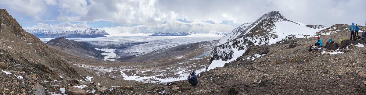
time climbing up to Rifugio Bertone where we stopped for a drink. We decided to head up on the longer variant route as the weather was perfect. We climbed up about 250 vertical metres to the top of the first ridge on the alternate route via Col Sapin. Here, Steve set up for time lapse photography and we enjoyed the extraordinary views. We decided the this day ranked among the best mountain scenery we had ever seen. The views of Col de la Seigne, Aiguille Noire and Mont Blanc were just spectacular with exceptionally clear skies. There were breathtaking views of a succession of huge glaciers, snow fields and sheer rock walls with an abundance of wild flowers in the foreground. A photographers dream! It was really hard to decide what to take a photo of! We lingered but we knew we needed to move on. We descended to Rifugio Bertone where we had a late lunch and the continued on the main TMB route.
The track was undulating with glorious views of the very close mountains and fields of wild flowers. However, I was regretting our choice of a heavy lunch of pasta and risotto! We were pleased to arrive at the very comfortable Rifugio Bonatti just before 5.00pm.
Day 6: Monday 27/06/2016 Rifugio Bonatti – La Fouly
Max elevation: 2548 m
Total climbing: 1212 m
Total descent: -1635 m
Average speed: 4.96 km/h
Total time: 07:05:56
Today was our longest day distance wise so we again got a fairly early start aided by the 6.15am breakfast. We sadly saw our Israeli friends for the last time as they were finishing their trip in La Fouly. I taught them a new English word, “undulating” and they used it frequently! Again the weather was glorious as we set off, just cooler than previous mornings.
We enjoyed fantastic views as we left Rifugio Bonatti, the mountains were so close you almost felt you could touch them. We descended into Val Ferret and climbed up to Rifugio Elena where we enjoyed warm drinks which was welcome as the wind outside was very icy.

Ice hiking
We rugged up and started the climb to the Grand Col Ferret passing mountain bikers pushing their bikes up! The climb was not too taxing even though it was steep, probably because of the cooler temperatures. We were warned by people coming down that we should put on our wind proofs before the top and make sure are hats were tied down as the wind was very strong. We did not hang around at the summit as it was so cool but the views were impressive as we crossed into Switzerland!
There was some snow on the descent but we did not need to use our crampons. The descent was fairly straight forward, with some road walking involved. Several hours later we arrived at our destination at La Fouly and we were again thrilled to get the room with the view! Glaciers right outside our window! The whole town was apparently booked out so we were thankful for our early reservation.
Day 7: Tuesday 28/06/2016 La Fouly – Champex
Max elevation: 1662 m
Total climbing: 843 m
Total descent: -810 m
Average speed: 5.14 km/h
Total time: 06:25:15
Today was meant to be the easiest day of the tour but was still a 15km walk with an elevation gain of 420 metres. We had an easy start to the day and enjoyed the great views from our balcony. It was a fairly easy walk along the valley which was pleasant due to the lovely weather, clear blue skies yet again.
We walked through some interesting villages with various building types with flower boxes and huge stockpiles of wood. We then entered a forest after walking on a high ridge, possibly comprised of glacial moraine. The forest track was decorated with wooden carvings of mushrooms, squirrels and other wildlife, none of which we saw alive!

Relais de Arpette
We had a cold drink at Champex Lac and pushed on for Relais d’Arpette. We arrived after a short walk through the forest on a track (which was not well sign posted) which followed the stream. On arriving we were informed that the Fenetre route was too dangerous so we would head back to Champex in the morning to walk the lower route to Col de la Forclaz.
We shared a nice meal that evening, sitting in our allocated seats with Margot and Zac from Washington DC who were on their honeymoon. There were walking the whole tour in six days, doing double stages most days (often 10 hours of walking per day) and sampling beer along the way!
Day 8: Wednesday 29/06/2016 Champex – Col de la Forclaz
Max elevation: 2032 m
Total climbing: 2165 m
Total descent: -2263 m
Average speed: 4.94 km/h
Total time: 06:01:34
We awoke to another beautiful day after a good sleep as we had our “comfort” dorm to ourselves. We walked back to the main TMB route just past Champex and I headed back to the boulangerie to buy some lunch.

Bovine route
The walk started through pleasant meadows and forests. It was then a long winding climb up to Alp Bovine with good views along the way. The weather was gorgeous and there was quite a few people on the path including several guided groups. We stopped at Alp Bovine for a drink, it was an interesting, if not quirky place. From here, there was a little more climbing until a long downhill section through forest to the Col de la Forclaz hotel. We enjoyed the afternoon sitting in the sun with our American friends from Georgia who finished their tour today.
We started to plan what we would do tomorrow if the forecast thunderstorms eventuated.
Day 9: Thursday 30/06/2016 Col de la Forclaz – Tre Le Champ
Max elevation: 2136 m
Total climbing: 1077 m
Total descent: -1213 m
Average speed: 4.17 km/h
Total time: 05:20:29
The forecast had us concerned about a possible electrical storm and we investigated how to get to Tre Le Champ by bus. It was a complicated route, bus, train, bus as it crossed the border into France. In the end we decided to walk after a storm passed through the area during the night.
We headed out at a reasonable time and thought we were doing well when we started climbing and then reached a sign to Champex! We were going in the wrong direction! After the unintended detour, we headed down the hill to find the actual trail (the signage was not great in Switzerland). Then it was a big climb up to Col de Balme which we made in very good time. Now we were back in France again. Climbing up 1000 metres per day somehow seemed easier now! There was some cloud and mist around but no sign of the predicted thunderstorms so we were glad that we had completed the walk. We decided to descend fairly quickly via the shortest route in case the weather changed. We had some interesting views of the peaks emerging from the mist as we descended. We arrived at the unique Auberge la Boerne, built in 1750, in time for a delicious lunch out on the terrace.

Towards Tre-le-Champ
Dinner was definitely a communal event, with the Rifugio full and all of us crowded around a few tables. It was a noisy affair. This “Auberge” was quaint but cramped and would be a dangerous place in the event of a fire.
Day 10: Friday 1/07/2016 Tre la Champ – Refuge du Lac Blanc
Max elevation: 2267 m
Total climbing: 1068 m
Total descent: -152 m
Average speed: 2.60 km/h
Total time: 03:41:24
We were in no hurry today as we only had three hours to walk. We made a leisurely start and it was yet again a stunning day. We didn’t leave the Rifugio on the correct path and luckily a passing cyclist indicated to us where to go! Only a 733 metre climb today and it started soon after leaving the Rifugio. Today we walked along the Grand Balcon Sud, a scenic route and an uninterrupted view of the Mont Blanc range. Wow! You really couldn’t take a bad photo.
Then we reached the passage delicat, a series of metal ladders, rungs and platforms up steep rock slabs. Then onto the snow. We used our crampons on the last ascent to the Rifugio even though a French woman laughed at us! They did make it easier climbing up the steep snowy incline towards the hut. The hut was situated in a position with a commanding view, but unfortunately the lake was frozen so we didn’t get the views that were in the book of reflections in the lake. It was cool up there and I got to use my 30 euro beanie I bought in Chamonix so that make me happy. The Rifugio was very nice but had lots of rules, no showers until 5.00 pm, bags kept downstairs in a locker. However, it was very pleasant on the terrace in the afternoon sun drinking tea and admiring the remarkable scenery.

Approaching Lac BLanc
We caught up with Rhinannon from Brisbane again who had been with us most of the way. She had also been advised against doing the TMB in Chamonix and as she was travelling by herself, she was quite anxious before she left. She hired mountaineering crampons and was happy to finally use them on the climb up to the Rifugio. We were pleased she didn’t eat all the blueberry tart, as she has been sampling pies all the way around the tour. We enjoyed lunch on the terrace and relaxed in the afternoon in preparation for a tough final day. I was hoping my large blister would hold out for one more day of walking.
That night someone asked if we were Rhiannon’s parents. I offered to adopt her.
That night we had a wonderful meal of vege soup, pork cheeks in red wine and berries with pasta. The sunset was like a painted band across the peaks and the Ibex came out to show off on the snow just as the sun set.
Day 11: Saturday 2/07/2016 Rifugio du Lac Blanc – Les Houches
Max elevation: 2356 m
Total climbing: 88 m
Total descent: -942 m
Average speed: 8.38 km/h
Total time: 01:32:51
We awoke to rain and some thunder. We waited a short time before leaving to avoid the worst of the weather. We had planned to walk all the way to Les Houches to complete the tour but the prospect of a long walk in the rain, trying to avoid electrical activity was not appealing.

Looking East over Lac Blanc
The full walk down would take more than 7.5 hours with 772 metre ascent and about 2000 metres decent. We were able to take the bail out option of walking to the gondola at La Flegere and catching it down to le Praz. Initially, when we got there the gondola was on hold due to lightning. Soon it was running again and it took no time at all to descend about 875 vertical metres down to Chamonix. We still had a 45 minute walk back to town and then the train back to Les Houches.
It was not quite the ending we imagined but it had been a superb eleven days of walking. It was a fitting end to a magnificent tour.
When we left Les Houches eleven days earlier, our host at Les Campanules told me that the sunshine would follow me on the tour. I’m not sure how he knew, but he was correct. We had stunning weather with cloud interrupting our views only on one day, with a total of less than an hour of rain over 11 glorious days. Wow, we were so lucky to see this incredible mountain scenery at its picture perfect best! It is a walk I will aways remember.
Clickable icons on a world map which open the related trip report
A detailed, searchable trip list with links to reports, photo galleries and other content
![]()