
10/10/2011 – 14/10/2011 Charlotte Pass – Club Lake
Participant: Stephen Davies
Day 1: Monday 10/10/2011 Charlotte Pass – Club Lake
Left home at 7:30am just in time to catch all the school zones after the school holidays. Picked up cheese and marshmellows, sliced turkey and bread rolls at Cooma. A 15 minute delay with road resurfacing near Cooma airport. Jindabyne at 11:00am, spillway in action with environmental flow release designed to flush out sediment etc in Snowy River. The weather remained overcast all the way down but mostly blue sky and a light breeze on arrival at Perisher Valley.
This route was reconstructed from memory using Google Earth Pro and GPS Visualizer.
Max elevation: 1851 m
Total climbing: 145 m
Total descent: -150 m
Average speed: nan km/h
Parked right up at roundabout at Charlotte Pass and left car at 1:41pm. Meet NPWS guy at Snowy crossing. He had been collecting water samples from Blue Lake as he does between 10 -20 th each month. He was crossing barefoot. He had also helped retrieve, from the Snowy River, the body of a boy who became lost last winter. Hypothermia most likely as he was found draped over a boulder in mid stream. I used volleys and waded across, harder to slip off! Air dried the feet for a couple of minutes whilst skinning up the skis. The cover looks better than on the last trip a couple of weeks ago. Its cleaner and more wide spread after the last big fall that came down between trips.

Skied almost the entire way to camp from river on snow, with only 3 10m odd grass or track crossings. Very cool breeze but just OK in red top. Fibrepile and goretex were added immediately at camp. Got set up quickly on arrival at 3:15pm. This was just in time as a cold front started moving through about 4:45pm. Had just been out for a short 300m run when things began icing up. The change was very windy and blowing a lot of very fine snow around. It was finding its way through the windward end of the tent until I stuffed the empty backpack right up against the doorway.
Soup at 5:30pm and gave dehyd beef satay 1 ½ hours to rehydrated. Lots of reading (FTM). There was another group of three another 500m up the creek. After a couple of hours of strong winds, and driving snow and spindrift (ended up with a 10m long 30cm high drift running parallel to the tent and only 1m away. The wind eased off and even had a couple of dead calm periods by about 8pm. 10pm blowing but intermittently. Found and listened to Snow FM at 91.70
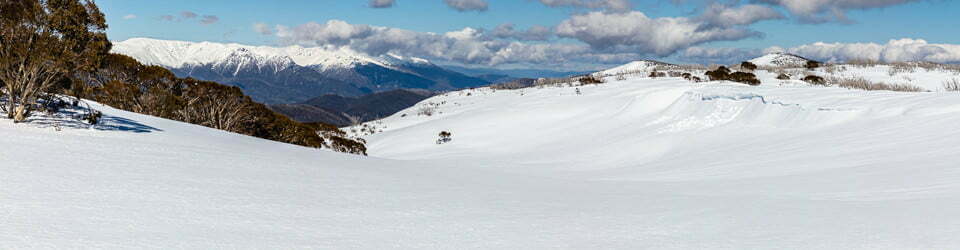
Day 2: Tuesday 11/10/2011 Club Lake region
This route was reconstructed from memory using Google Earth Pro and GPS Visualizer.
Max elevation: 2048 m
Total climbing: 715 m
Total descent: -719 m
Average speed: nan km/h
-1 degrees at Charlotte Pass at 8am. Blustery winds all night, lots more spindrift inside front of tent. Wind scoured icy and windblown spindrift covering the nearby hills. All grassy patches now have a light cover. Visibility variable from 10m to Charlotte Pass depending on wind and cloud.
The morning remained dubious for skiing options. Two of the three neighbours had a run on the hill above me but made it look terrible and reported on plenty of icy patches. I headed up the valley to Club Lake to take some pictures. I shot a few then did a run back down to the flats. It was considerably better than I had expected with a mix of just starting to soften ice and fresh drifts. Headed back up the ramp between Mt Lee and Carruthers Peak for some more photos. The light was good and changing rapidly, clouds whizzing past and occasional patches of blue sky. I skied back to the tent as the clouds started to hang around, needed a couple of breaks on the run waiting for some light/contrast to descend. The clouds stuck around right through lunch from 12 to 1:30pm.

I left for an afternoon ski around 2:00pm but was back in the tent by 3:30pm as it hadn’t improved. I was very ordinary visibility and variable snow. No falls but also no style. Didn’t find any phone reception, even on the ramp with a clear view of Charlotte Pass.
In all a cold, windy, overcast day. Dressed in lifa, red top, fibrepile and goretex for first run. Fibrepile and overgloves required all day as well as a beanie, except in the afternoon. The wind died off in the early evening and it was calm by about 8:30pm
Day 3: Wednesday 12/10/2011 Carruthers Peak
This route was reconstructed from memory using Google Earth Pro and GPS Visualizer.
Max elevation: 2137 m
Total climbing: 1275 m
Total descent: -1274 m
Average speed: nan km/h
Action day as the wind is gone and the sky is blue.
I headed up towards Club Lake again for some contrasting, fine weather photos around 8:45pm. Then skied the ramp and down by about 10:00am. Spent plenty of time taking photos waiting for the ice to soften a bit. Had a good run back to the tent.
I geared up and headed up Carruthers Peak. Meet another Victorian, Pete (out by himself on a day trip) and had morning tea and a chat with him on the summit. He descended straight down to the Lake (a very ordinary effort and style). I went down the way I’d climbed up and had a fantastic confidence building run getting a good feel for the new gear. Got a short call out to Suey.
Had lunch at tent and returned to Carruthers summit. Ran into Pete again. No one else on the mountain. Had another great run back to the tent. After some afternoon tea and then went back up about ¾ of the way again. The left cable fell off! Fortunately it only required tightening. I tried Sue again but was informed I had no credit! A little tricker on this run with it starting to freeze, so I called it a day when I got back to the tent around 4:45pm
Really annoying have been the Navy helicopters buzzing around from 9:00am to 5:00pm everyday so far doing the training runs.
It remained a pleasant evening with just a few clouds hovering about Mt Lee. I got out about 10:00pm for a few moonlight landscapes.
Day 4: Thursday 13/10/2011 Mount Lee – Carruthers Peak
This route was reconstructed from memory using Google Earth Pro and GPS Visualizer.
Max elevation: 2137 m
Total climbing: 983 m
Total descent: -984 m
Average speed: nan km/h
Another beautiful fine morning, mostly still with an occasional puff of wind. The first helicopter arrived at 9:05am, but it was the last for the trip.
I headed back up the ramp at 9:05am. Did three full runs until 12:00pm with the snow being of really good compliant spring consistency. Had a snack and rest on a grassy knoll before ascending Mt Lee. On top I enjoyed the stunning view for a while (without my camera) then managed a fall line descent just to the right of the summit cornice. Was a fantastic run with no falls, although I almost went over when I hit a patch of super slow old snow.

Was back at the tent for a late 2:00pm lunch. Dehydrated hommus only takes minutes. Then headed up Carruther Peak at 2:45pm for a final run back down the main ridge. Had managed to get a SMS to Sue who rang back. I said I hadn’t seen anyone all day long except at breakfast. 5 minutes later I ran into the two remaining Victorians and chatted some more. Back to tent at 4:45pm.
Had a very enjoyable afternoon at the tent just enjoying the warmth in the afternoon sun.
The day remained much better than had been forecast, mostly cloud free and still with an occasional breeze. A few more clouds formed in the late afternoon.
Day 5: Friday 14/10/2011 Club Lake – Charlotte Pass – Mount Guthrie
This route was reconstructed from memory using Google Earth Pro and GPS Visualizer.
Max elevation: 1851 m
Total climbing: 154 m
Total descent: -147 m
Average speed: nan km/h
With a forecast of showers and possible thunderstorm I had decided to pack up and leave early and try a catch a few runs on Mt Guthrie before heading home.
Left the campsite just after 8:00am on a very firm base. There was a bit of manoeuvring around grassy patches and couple of walks that had been added since Monday. Met a few people at the crossing. Talked a pair of skiers into taking off their boots to keep them dry for the day and talked a 60ish old couple out of walking the lakes Circuit!
I crossed in my volley sandshoes again, squeezed them dry then put on socks and walked up the hill in them, much easier than boots. Back at car about 9:45am.
Ended up doing only two runs on Mt Guthrie, the snow being quite variable. I headed out to Dalgety where I had lunch in the park next to the bridge. I then checked out the impact of the environmental flow from Lake Jindabyne on the Dalgety Weir and the short stretch upstream before heading home.

Back home around 6:00pm after what was probably the best trip since I was last up at the same spot in 2009.
Clickable icons on a world map which open the related trip report
A detailed, searchable trip list with links to reports, photo galleries and other content
![]()