Tag Archives: 2016

Punta Literniccia

Calenzana – Bonifatu – Turarelli – Galeria – Girolata – Cirzu – Serriera – Ota – Marignana – E Case – Cargese : Mare e Monti, CORSICA

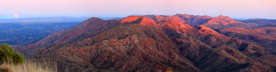
26/5/2016 – 5/6/2016     Tra Mare e Monti   

                                            Calenzana – Cargese, CORSICA 

Distance: 176.6km   Total Ascent: 9100m   Total Descent: 9425m   Moving Time: 48 hours

Participants: Stephen Davies (Photos), Sue Davies (Report, Photos)

The longest-standing and easily the most wonderful long-distance route in Corsica, the Mare e Monti holds true to its name and provides a roller coaster of treats ranging from breathtaking coastline with blue sea and beaches to some awe-inspiring mountainous landscapes” Gillian Price (Walking in Corsica – Long Distance and Short Walks, Cicerone Guides, 2013)

It was an adventure even getting to the start of this walk that involved several days of travel. We flew to Ajaccio, the capital city of Corsica. The following day we caught the train to Calvi, changing at Ponte Leccia. The trip duration was nearly five hours but was very scenic, firstly through the mountainous interior and then to the picturesque coast. Calvi is a gem with it’s commanding citadel and turquoise sandy beaches.

After planning to catch the school bus to the start of the walk at Calenzana, we purchased our tickets ahead of time and waited at the bus stop. No bus. I returned to the store where we purchased the tickets and they sheepishly informed me they neglected to advise the bus company to pick us up! They refunded our money but we had missed the only bus that day and our only option was to catch a taxi (35 euros).

The taxi driver dropped us in the main square at Calenzana so we still needed to find our accommodation. We stayed at a lovely bed and breakfast, A l’Ombre du Clocher. The home made jams with fresh bread for breakfast were amazing.

Continue reading

Loading

Long Gully – Cooyoyo – The Castle – Monolith Valley – Sunset Cave – Mt Cole

2/04/2016 – 6/04/2016   Long Gully – The Castle – Mount Cole circuit

                                            Morton National Park, NSW

                                            Yuin country

Distance: 44km   Total Ascent: 1955   Total Descent: 1955m   Time: 23 hours

Participants: Mandy Creighton (Saturday & Sunday), Stephen Davies (Photos), Sue Davies (Report), Dave Whitelaw (Saturday & Sunday)

Steve and I started at Long Gully campground on Friday afternoon, enjoying the warm afternoon sun with a goanna for company.

Mandy and Dave joined us a bit later, sharing in the ritual of burning Sue’s expired business papers throughout the evening and sampling delicious bakery treats from the Heritage Bakery in Milton. Continue reading

Loading

Roy Peak summit

Roys Peak

Friday 5/02/2016   Wanaka Mount Aspiring Road – Roys Peak summit return

                                  Wanaka, NEW ZEALAND           

Participants: Stephen Davies (Photos), Sue Davies (Report)

As we were due to head out on a multi day walk (rated as “hard”) the next day we wanted a day walk that would stretch our legs without wearing them out. We had underestimated Roy’s Peak.

Continue reading

Loading

The Outlet – Brod Bay

Tuesday 2/02/2016   The Outlet – Brod Bay return

                                      Te Anau district, NEW ZEALAND

Participants: Stephen Davies (Photos), Sue Davies (Report)

As a warm up for the multi-day hikes to come we decided to revisit part of the Kepler track for the afternoon to walk from The Outlet to Brod Bay and back.

Continue reading

Loading

Sharplin Falls – Mount Somers

Wednesday 24/02/2016   Sharplin Falls Reserve – Mount Somers summit return

                                               Canterbury District, NEW ZEALAND

Participants: Stephen Davies (Photos), Sue Davies (Report)

As the weather was favourable we decided to try the summit again. We had done this walk two years ago in thick fog and saw no views at all.

We started the track just after 8:30am with a strong feeling of deja vu as we had walked out from the circuit on this track only two days earlier. Continue reading

Loading

Sharplin Falls – Pinnacles Hut – Woolshed Creek – Mt Somers South Face

19/02/2016 – 22/02/2016   Mount Summers circuit – Sharplin Falls

                                                Canterbury District, NEW ZEALAND

Distance: 31.5km   Total Ascent: 2340m   Total Descent: 2340m   Time: 18 hours

(excluding side trips)

Participants: Stephen Davies (Photos), Sue Davies (Report)

Continue reading

Loading

Freehold Creek – Dumbbell Lake – Lake Ohau

Thursday 16/02/2016   Freehold Creek – Dumbbell Lake

                                           Ohau Conservation Reserve, NEW ZEALAND

Distance:  18.7km   Ascent: 1200m   Descent: 1200m   Walking Time: 6 hours 25 minutes

Participants: Stephen Davies (Photos), Sue Davies (Report)

We had a slow start from Lake Ohau lodge as Steve needed to let his large breakfast settle. We headed off from the Sawyers creek carpark by 11:00am.

We wandered through the dry grass for what seemed like a long time until we found the Alps to Ocean bike track and then the Freehold creek track. The pleasant trail then followed the creek climbing gradually for three kilometres until we reached the tree line. We passed several scree slopes and the view improved. There was a well positioned water pipe and cup for thirsty trampers. Continue reading

Loading

Photo: Sue Davies

Matukituki Valley – Rob Roy Glacier – Aspiring Hut – French Ridge Hut

11/02/2016 – 14/02/2016   Raspberry Creek – French Ridge hut return

                                                Mount Aspiring National Park, Otago region, NEW ZEALAND


Distance: 50km   Total Ascent: 2610m   Total Descent: 2610m   Time: 19 hours

Participants: Stephen Davies (Photos), Sue Davies (Report)


Continue reading

Loading

Young River – Gillespie Pass – Wilkin River – Siberia Hut – Crucible Lake

6/02/2016 – 10/02/2016   Young River – Gillespie Pass – Wilkin River – Siberia Hut – Crucible Lake

                                               Young – Wilkin Circuit, NEW ZEALAND

Distance: 61.4km   Total Ascent: 2660m   Total Descent: 2300m   Time: 26 hours

Participants: Stephen Davies (Photos), Sue Davies (Report)


Day 1: Saturday 6/02/2016   Young River – Young Hut

Early on Saturday morning we headed off for our planned trip to visit Aspiring, French Ridge and Liverpool huts in the Matukituki River West Branch Valley. However, before we were to of town we recalled DOC’s advice that this area would be exceptionally busy over the Waitangi long weekend and with this in mind altered course and drove off towards Makarora to do the Gillespie Pass (Young-Wilkin) Circuit instead.

We were a little surprised on arrival to find the car park near the Young River close to full and a party of thirteen trampers heading off just before us. Continue reading

Loading