
Tuesday 13/02/2024 Mount Amos Summit Carpark – Mount Amos Track – Mount Amos
Freycinet National Park, lutruwita / TASMANIA
Paredarerme country
Participants: Stephen Davies (Photos), Sue Davies (Report)
We decided to try to get an early start with the predicted maximum being 33 degrees by the afternoon. We arrived at the track head around 7:30am with plenty of parking available. Other groups were arriving but it seemed that they were mainly heading to Wineglass Bay.
Max elevation: 453 m
Total climbing: 460 m
Total descent: -419 m
Average speed: 2.57 km/h
Total time: 04:05:12
Our climb to the top was mostly on our own. There are plenty of warning signs that the trail is steep and challenging and should not be attempted in the wet. It had not rained for at least a week so we felt confident proceeding.
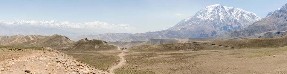
The trail quickly starts climbing and becoming rougher as we leave the vegetation behind. Soon we are working our way around steep and at times quite smooth pink granite slabs. On the ascent, we didn’t have much trouble with grip, not so much on the descent. This hike is a test for the ankles and Achilles as in many places are at full stretch. Closer to the summit the trail levels slightly and before we knew it we had reached the classic spot at the summit for those famous Freycinet panoramic views.
Here we lingered for quite some time, chatting to different people at the top as they came and went. There was a man and his young son from Alice Springs who really didn’t understand the local warnings for “heat” at 30+ degrees (as Alice Springs in central Australia is extremely hot in the summer months). Later, a bare-chested tattooed man asked us how old we were and told us we were doing really well (we can only surmise that we must have looked ancient to him!).

Sue descending granite slabs on flanks of Mount Amos
We climbed down past the summit to some alternative viewpoints and lingered until we decided it was time to descend. Going down was a bit trickier, as usual, as the steep slabs seemed more slippery, even though dry. We were more than happy to take our time as the heat was also starting to build. We met two couples on their way back down who hadn’t reached the top due to a fear of heights or just a general fear of climbing over the slabs.
It was over 30C by the time we finished so we decided to call it a day. It turned a to be a good choice as a storm rolled in that afternoon with some rain, just enough to make those slabs slick and slippery.
We had done this hike six years ago but the views from the top are so impressive it was worth repeating. The climb up and down is still a bit of a challenge, enough to keep it interesting. Overall a great way to spend a few hours.
Information on Parks Tasmania signage along the way
TOORERNOMAIRREMENER
This area was once the homeland of the Toorernomairremener Aborigines who hunted and lived along these shores.
Every feature was known and named. Today, very few places carry Aboriginal names as much of their language was ‘lost’, forced aside, or inappropriately used. Today’s Tasmanian Aborigines are reviving their language. Some European names along the coast are reminiscent of Europeans’ early encounters with Aboriginals. Friendly Beaches in the northern section of the park describes the first friendly encounters between two vastly different cultures, while the Bay of Fires, to the north of Freycinet, was named by Captain Furneaux in 1773 after sighting many Aboriginal fires burning along the coast.
Mt Amos track – WARNING
Mt Amos track is a challenging walk for physically fit and well equipped walkers. Please take the time to read the notes below before attempting the Mt Amos track.
• This track requires boulder scrambling and has some extremely steep sections.
• The track crosses rock slabs which become very slippery when wet. Do not attempt during or immediately following rainy/wet conditions.
• Allow at least 5 hours of daylight to complete this track (note short daylight hours in winter in Tasmania).
EXPLORERS
… The Dutch
The first known charting of the Tasmanian coastline the landmarks named was Schouten Island, which lies t was by Dutch explorer Abel Tasman in 1642. One of to the south of Freycinet Peninsula. Justus Schouten was a member of the Council of the Dutch East India Company whose ships sailed the southern oceans in search of exotic spices for trade. Tasman’s explorations were acknowledged over two hundred years later when Tasmania was named after him in 1855 and the island’s former name – Van Diemen’s Land – was relinquished.
… The French
Many features along the East Coast of Tasmania carry French names, resulting from the Baudin Expedition of 1802. Napoleon Bonaparte directed Captain Nicolas Baudin – expedition leader of two ships (Le Geographe and Le Naturaliste) – to “chart the coast of the Great South Land, including Antony van Diemen’s Land, for research of all kinds and to increase the mass of human knowledge”. Freycinet Peninsula was named after Louis Freycinet, sub-lieutenant on Le Geographe. Cape Baudin is on the eastern side of Schouten Island and was named in 1959 to commemorate Baudin, while Mt Baudin, one of the Hazards Peaks, was named in 2000 to commemorate the bicentenary of the Baudin expedition.
Some other French place names within the park include Cape Degerando on the south coast of the Peninsula (after a social anthropologist who wrote a guide for the study of Aboriginal people encountered on the expedition), Cape Faure on the south coast of Schouten Island (the expedition’s geographer), Cape Forestier to the south of Wineglass Bay (one of Napoleon’s generals who helped organize the expedition), Cape Sonnerat on the south-east tip of Schouten Island (a French naturalist), and Cape Tourville east of Coles Bay (a famous French Admiral).
WHALERS
The crystal clear, turquoise water of Wineglass Bay once ran red with the blood of slaughtered whales. Shore-based whaling stations were scattered around the Peninsula, including at the southern end of Wineglass Bay, Bryans Beach, Crocketts Bay, Hen and Chicken Bay, Befuge Island and Parsons Cove (The Fisheries).
The Hazards – the line of mountains that define Freycinet – is not, as you might expect, named after the hazardous nature of the peaks, but rather, both it and Hazards Beach are named after American Albert ‘Black’ Hazard, captain of a whaling ship active in the area in the 1820s. His ship, Promise, came aground on the rock that bears the name. Promise Rock lies just off Hazards Beach. George Meredith, one of the first settlers at Swansea, established a whale ‘fishery’ at. • Parsons Cove in 1824, which became known as The Fisheries.
Shore-based whaling was on the decline by the 1840s due to years of ruthless exploitation. The southern right whale had been hunted to the brink of extinction. These days, these magnificent creatures can be seen during winter as they migrate north from the Antarctic to breed in warmer waters and return south in spring. Keep a lookout from Cape Tourville or any of the Park’s peaks.
EARLY SETTLERS
In the 1830s, an early settler named Silas Cole – after whom Coles Bay is named – burned shells from the large Aboriginal middens on Richardsons Beach to make lime for use in mortar.
A sealer named Joseph Stacey discovered coal in the mudstones on the western part of Schouten Island after he was washed ashore in 1809. It was first mined commercially (and quite unsuccessfully) from around 1840 to 1880. At one point, Edward Crockett was mine manager. Crocketts Bay on the north coast of Schouten is named after him.
At around the same time, Chinese tin miners arrived to briefly work the alluvial deposits on Schouten Island. Chinese Creek on Schouten Island is named after them.
Sheep and cattle grazing were carried out on parts of the Peninsula as early as the 1850s and continued on Schouten Island until the 1960s. Bryans Beach, Bryans Corner and Bryans Lagoon are named after the three generations of Bryans who lived and worked on the Peninsula. Cooks Hut, Cooks Beach and Cooks Corner are named after Athol Cook who farmed in the area in 1910.
Mt Amos was named after Adam and John Amos – Swansea district farmers for Lieutenant George Meredith, the first settler of the East Coast. Mt Graham – after one of the early respected ‘citizens of Swansea. Morris’ three-storey warehouse in Swansea (still standing) was originally built for Mr Graham. Mt Dove is named after a Sec: sh Reverend who had a diverse career in the early colony, beginning with serving as a missionary to the Aborigines of Flinders Island, before being a Religious Instructor to the convicts in the Probation Station at Darlington in 1842, and finally as Presbyterian Minister to the early settlers at Greater Swanport. Mt Mayson was named in honour of Rev Joseph Mayson – rector of the Anglican Church at Swansea for many years.
EARLY TOURISTS
Coles Bay and Freycinet Peninsula have been popular holiday destinations for over 100 years, with early visitors arriving by boat or steamer from Swansea. One of the first to promote the tourist potential of the area was Harry Parsons, after whom Parsons Cove is named. He retired to Coles Bay in the 1920s and established shacks at The Fisheries.
A short time later, in 1934, Ron Richardson leased the Chateau Holiday Units from the Government. This complex has since been redeveloped as Freycinet Lodge. The beach between the Lodge and the Visitor Centre is Richardsons Beach.
SOME MYSTERIES REMAIN…
Wineglass Bay is one of the world’s most famous beaches, yet the origin of its name is unknown. Is the water as clear as a wineglass, or is the bay shaped like a wineglass? Or was the water once wine-red with the blood of slaughtered whales?
And there are others you might like to ponder … Barrel O’Tar Cliff… Half Lemon Rock … Hen and Chicken Bay … Chain Locker Bay … Honeymoon Bay …
The local landscape features, geology, scenic highlights, flora, fauna, indigenous history, white history and other walks in the area (Gemini)
Freycinet National Park: A Geological Tapestry of Coastal Beauty
Freycinet National Park, a jewel of Tasmania’s east coast, boasts a diverse landscape sculpted by millions of years of geological processes. This haven for nature lovers and outdoor enthusiasts offers dramatic granite peaks, pristine white-sand beaches, towering sea cliffs, and lush rainforests, all interwoven with a rich cultural tapestry.
Landscape Features:
Hazards Mountains: The centrepiece of the park, these majestic granite peaks, including the iconic Mt. Amos (454m) and Mt. Freycinet (620m), were formed by a massive granite intrusion over 200 million years ago. These weathered peaks, adorned with pink and orange hues, rise majestically from the coastline, creating a breathtaking panorama.
Wineglass Bay: One of the most photographed beaches in Australia, Wineglass Bay boasts a perfectly curved arc of pristine white sand, turquoise waters, and granite headlands framing the picture. This sheltered bay offers a picturesque haven for swimming, sunbathing, and kayaking.
Friendly Beaches: Unlike Wineglass Bay, Friendly Beaches face the exposed Southern Ocean. Characterized by dramatic windswept dunes, powerful surf, and rugged rock formations, this area offers a wilder coastal experience for seasoned beachgoers.
Coles Bay: This sheltered bay serves as the gateway to the park, offering stunning views of the Hazards Mountains and access to boat tours, kayaking adventures, and walking trails.
Lake Dobson: Nestled amidst towering forests, this freshwater lake reflects the surrounding mountains and offers a serene escape for paddleboarding and wildlife observation.
Geology:
The park’s landscape is a testament to its complex geological history. The Hazards Mountains are remnants of a vast granite batholith formed deep within the Earth’s crust. Over millions of years, weathering and erosion sculpted these granite giants, exposing their pink and orange feldspar crystals. The dramatic coastline reflects the erosive power of wind, waves, and ice ages, shaping sea cliffs, beaches, and rock formations.
Scenic Highlights:
Wineglass Bay Lookout: Witness the iconic curve of Wineglass Bay from above, offering panoramic views of the Hazards Mountains and the turquoise waters lapping the shore.
Hazards Beach and Mt. Amos Hike: Challenge yourself with a hike to the summit of Mt. Amos, rewarded with breathtaking panoramic views of the coastline and surrounding mountains.
Friendly Beaches: Experience the raw power of the Southern Ocean from Friendly Beaches, witnessing dramatic waves crashing against the rugged coastline.
Coles Bay Lookout: Enjoy panoramic vistas of the Hazards Mountains, Wineglass Bay, and the Freycinet Peninsula from the conveniently accessible Coles Bay Lookout.
Walks within the Park: Explore the diverse landscapes through numerous walking tracks, ranging from the iconic Wineglass Bay Circuit to shorter strolls through forests and along coastlines.
Local Flora:
The diverse habitats of Freycinet National Park support a rich variety of plant life. Coastal heathlands showcase flowering heath, tea-tree, and banksias, while sheltered forests boast towering eucalypts, blackwoods, and tree ferns. The park is also home to unique and threatened plant species, like the endangered Zieria ornithoptera (Wedge-leaved Zieria).
Local Fauna:
A diverse array of animals call Freycinet National Park home. Look out for wallabies and pademelons grazing in the forests, echidnas foraging in the undergrowth, and colourful birds like parrots, honeyeaters, and kookaburras flitting through the trees. Marine life thrives in the surrounding waters, with whales, dolphins, seals, and penguins occasionally gracing visitors with their presence.
Indigenous History:
The park holds deep significance for the indigenous Palawa people, who have inhabited the area for thousands of years. Evidence of their connection to the land can be found in archaeological sites, including middens and stone artefacts. The park recognizes and respects the ongoing cultural connection of the Palawa people to their traditional lands.
White History:
European explorers first arrived in the area in the early 1800s. The park was named after French explorer Louis de Freycinet, who charted the coastline in 1822. Over the years, the area saw settlements, fishing activities, and eventually tourism become the primary industry.
Other Walks:
Freycinet National Park offers numerous walking tracks that cater to diverse abilities and interests. Popular options include:
Hazards Beach and Mt. Amos Hike: A challenging multi-day trek with stunning views.
Wineglass Bay Circuit: A moderate day walk showcasing the iconic bay and surrounding landscape.
Waterfall Creek Track: An easy walk through rainforests leading to a refreshing waterfall.
&Many shorter thematic walks focusing on specific aspects like geology, history, or birdwatching.
Clickable icons on this world map will open the related trip report
A detailed, searchable trip list with links to reports, photo galleries and other content
![]()