
Saturday 16/09/2023 Perisher Valley – Porcupine Road – Porcupine Walking Track – Rock Creek – Porcupine Rocks – Wheatley Link – Betts Creek – Perisher Gap – Kosciuszko Road
Kosciuszko National Park, NSW
Ngarigo Country
Participants: Stephen Davies (Photos, Report), Sue Davies
This morning we only completed three very short runs on Sturt T Bar before calling an end to our resort skiing season. With all bar the Village Eight chair lift on wind hold there were limited options and lift lines way longer than our liking so we swapped out our ski boots for hiking boots and were on our way.
Max elevation: 1918 m
Total climbing: 336 m
Total descent: -336 m
Average speed: 4.20 km/h
Total time: 02:36:50
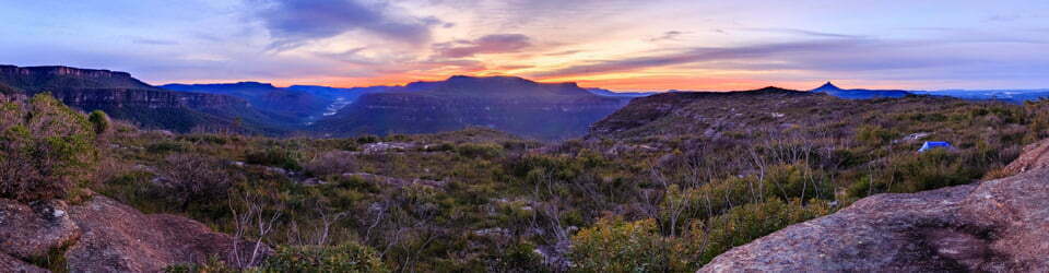
The forecast windy day certainly didn’t disappoint as we were buffeted by the frequent gusts on top of the 60-70km/h winds as soon as we began. Thredbo AWS had recorded a gust of 113 overnight. When we were last out here in February 2022 National Parks were hard at work upgrading the track, we were very impressed with what they have down. Apart from a couple of short sections of metal boardwalk over wetter ground, there is now an inlaid stone path all the way to Porcupine Rocks, ensuring a much better chance of keeping feet dry and protecting the delicate ecosystem at the same time. Today there were still a few snow drifts across the track but for most of the walk, the snow was long gone.
The wind was unrelenting throughout, with Thredbo AWS recording gusts to 100km/h whilst we were out. There were several times we were bodily blown around, so our walking was at times unsteady and holding a camera steady proved impossible. Despite the windy conditions, we had blue sky overhead throughout and crossed paths with about seven other walking groups.

Although the views from Porcupine Rocks were excellent we didn’t linger, continuing on our way post haste to avoid the wind. Following the Wheatley Link back to Perisher Gap over Betts Creek had us on an earthen track following the snow pole line, as there are a couple of sharp turns along the way you should pay attention to the direction indicated by the red metal markers on the poles.
There was plenty of exposure to the headwind along Wheatley Link and numerous opportunities to get wet feet on the wet low sections around Betts Creek. Along the final hump before Perisher Gap, Sue found a phone attached to a powerpack with its display still on. Ten minutes later we met the owner on her way back looking for it after it had fallen out of her pack.
From where Wheatley Link ends at Perisher Gap we returned down along Kosciuszko Road to Kahane Lodge to spend the rest of the day out of the wind.
Clickable icons on this world map will open the related trip report
A detailed, searchable trip list with links to reports, photo galleries and other content
![]()