
Saturday 20/10/2018 Mount Lady MacDonald
Banff National Park, Alberta, CANADA
Participants: Sue Davies (Photos, Report), Beth Davies
This is a stunning and exhilarating day hike if the conditions are favourable. Be prepared for constant climbing uphill, steep at times, for five kilometres. This is a well frequented trail but is adjacent a wildlife corridor so the usual precautions including carrying bear spray are necessary.
Max elevation: 2510 m
Total climbing: 1380 m
Total descent: -1383 m
Average speed: 3.25 km/h
Total time: 05:04:16
The trailhead starts at the Cougar Creek carpark near the town of Canmore. There are limited signs along the route.
We started out on what promised to be a stunning fall day. From the carpark we followed the trail along the western side of the creek before the long climb began. The path climbed steeply through the forest and we warmed up quickly despite the single digit temperatures.
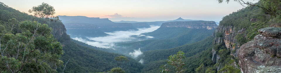
It was great when we passed above the tree line to be rewarded with fantastic views of the peaks surrounding Canmore but the best was yet to come.
We soon reached the helicopter landing pad where the views were awesome. We had a drink and a snack. Others were happy with reaching this point and decided to descend. The breeze had picked up and we needed to decide whether to push for the summit. The trail looked steep and sketchy. Decision made, we would go for it!

Still climbing
The “trail” was indeed sketchy and it was a case of climbing two steps and sliding back one on the loose scree slope. It was steep and testing and a matter of picking the most favourable route. Climbing basically straight up it didn’t seem to take too long to reach the summit and we were well rewarded with panoramic views in all directions. A snow covered razor sharp ridge continued on with serious exposure. This was far enough for us!
The descent on the scree slope was difficult and required care. Overall the trail conditions were very good with only small areas of mud and some tricky sections of dirt covered ice. It was very good considering the time of year. The descent beyond the helicopter pad was long but it was an excellent day hike. Beth said it was the “best day ever”.
Clickable icons on a world map which open the related trip report
A detailed, searchable trip list with links to reports, photo galleries and other content
![]()