
4/09/2014 – 11/09/2014 Lake Bohinjsko – Krn
Trenta and Triglav region, Julian Alps, SLOVENIA
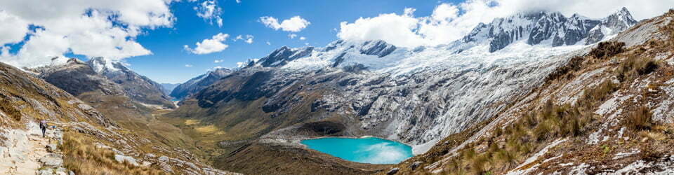
Distance: 88km Total Ascent: 5600 m Total Descent: 5200m Time: 41 hours
Participants: Stephen Davies (Photos, Report), Sue Davies
This eight day trip through the Julian Alps allows a great overview of this scenic area. Lake Bohinjsko is accessible from Bled by bus but the frequency of these drops off outside of the summer season. Features include beautiful forests, crystal clear streams and waterfalls and majestic mountain views. The Doms (usually larger) or Kocas (offering seasonal bunk style accommodation) provide hearty food and welcoming hosts.
Day 1: Thursday 4/09/2014 Lake Bohinjsko – Dom Krnskih Jezerth
Max elevation: 1815 m
Total climbing: 1393 m
Total descent: -552 m
Average speed: 3.68 km/h
Total time: 07:32:24
From Bled we walked fully laden with our packs and hiking gear 1km to the bus stop. After arriving at Lake Bohinjsko at 10:15am we started our walk. The bus stop was about 90 minutes walk before the carpark to the waterfall, where we could have commenced using a taxi.
We enjoyed a fantastic forest walk along a wide and very well built track with a steady gradual incline up to Dom Kong, a massive four storey “rifugio”. From here we caught some great mountain views, seeing all the peaks despite the full cloud cover.

Difovski Vrh
We needed to pay attention to our navigation, as some of the trail intersections had no signage and our knowledge of Slovenian was non existent! The place names were very confusing to us, often comprising of multi word names such as “Dom beside the blue lake”. The day finished with a walk through a small cow farm just as we reached Dom Krnskih Jezerth.
Our meal of goulash with polenta and strudel was basic but hearty. There were only two other guests and four workers. This is the advantage of walking near the end of the season!
Day 2: Friday 5/09/2014 Dom Krnskih Jezerth – Krn return
Max elevation: 2245 m
Total climbing: 1109 m
Total descent: -1098 m
Average speed: 3.05 km/h
Total time: 08:12:37
We decided to stay an extra night in the Dom to do a day walk to the summit of Krn (love the place names with no vowels!) and there was no problem finding a spare bed! After our basic eggs and “ham” (bacon) breakfast we were out the door by 8:15am for a cloudy start to the day.
Aiming for Krnsko Jeroro first we found ourselves instead at Batognisko seldo after taking a wrong turn. Sue was very unhappy! We had to go back to Dom over Batognica. There were clouds around the peaks and elsewhere.

Views of Batognica (2164m) from Krn saddle
Lots of World War I relics are to be found around here, left as if the war had just ended – shell cases, guns, barb-wire, signs, steep staircases and bunkers cut high into cliffside.
Lunched on sauerkraut and bean soup followed by apple strudel at Dom Koca. As expected, there was no English spoken here.
Then we headed over Krn’s summit to an awesome walk back down off it with rolling clouds and lots of mountains surrounding us.
We were the only remaining guests tonight. Some vegetable and barley soup, then tomato-less spaghetti bolognese for dinner. Slovenian cuisine was not our favourite of the European choices.
Day 3: Saturday 6/09/2014 Dom Krnskih Jezerth – Trenta via Soca
Max elevation: 1448 m
Total climbing: 78 m
Total descent: -651 m
Average speed: 3.40 km/h
Total time: 03:19:50
Max elevation: 725 m
Total climbing: 323 m
Total descent: -218 m
Average speed: 10.82 km/h
Total time: 02:14:08
We left early for a return to trip to the picturesque Lake then breakfast of eggs and ham. From here it was a good grade but rocky descent through a nice forest. Our aim was to hitch the section on the road but we were not able to catch a ride whilst walking the road to Soca which turned out to be just as well as we did an unexpected 1.5km side trip to an amazingly beautiful series of waterfalls of crystal clear aquamarine water.

Slap Lepenjica
From Soca we did manage to quickly pick up a ride from a lovely Israeli couple but unfortunately for us we got dropped off about 1.5km past Trenta as there was no signage to mark the town.
Our instructions for our accommodation was to ask for the owner at the local shop. This was time consuming as it appeared all the local residents had gathered to purchase their manually sliced meat at that moment!
Here we had a spacious house to ourselves for the night for only 23Euros each. A very late, 3:00pm, lunch of fresh bread, cheese and tomato.
Home made dinner tonight of ravioli with tomato, eggplant and sheep cheese, followed by some cheese curd pie and apple strudel.
Day 4: Sunday 7/09/2014 Trenta – Zasavska Koca
Max elevation: 2075 m
Total climbing: 1451 m
Total descent: -27 m
Average speed: 3.19 km/h
Total time: 06:19:31
We enjoyed our self prepared muesli, yoghurt and a banana for breakfast.

Views from below Zadja Lopa (2115m)
From Trenta we followed a road into a delightful forest before climbing steeply to a saddle, then over a ridge to Koca. The climb itself becoming steeper as we progressed. We encountered very few people along the way but there were more around the Dom itself where we arrived at 2:30pm.
Lunch consisted of bread rolls, sheep cheese and tomato.
Dinner of delicious thick vegetable soup, pancakes and chocolate topping.
Day 5: Monday 8/09/2014 Zasavska Koca – Koca na Dolicu – Zasaiku
Max elevation: 2395 m
Total climbing: 903 m
Total descent: -901 m
Average speed: 2.56 km/h
Total time: 07:34:42
The overnight clouds had gone by sunrise leaving the skies clear and providing visibility for lots of photos.
Breakfast consisted of standing Slovenian fare; eggs and ham.
We spent time taking photos of the two nearby lakes before a climb to the saddle. Lots of loose rocky paths with some exposure (very common in the Julian Alps) and lots of slipping.

Rjavo jezero (below Zasavska koca)
We saw about 20 other hikers today which was a large number for this trip. We opted out of the alternate route back involving a 250m ascent and returned back the same way. It looked pretty exposed and Sue was not comfortable especially in the knowledge that the previous year a woman had fallen to her death in this area as part of a trip run by our local bushwalking club.
The weather remained clear all morning but had clouded over again by 5:00pm.
It was an interesting place as they lock the indoor toilet at 10:00pm, requiring one to head outside, down a hill to use the pit toilet! As this was a very high Dom water was limited in supply with bottled water only available.
Because it was our second night we alone were offered a special “paprika” stuffed with meat and rice meal option. I’m not sure what we might have done to offend, as the yellow capsicum was mouldy! We politely declined!
Day 6: Tuesday 9/09/2014 Zasaiku – Koca pri Triglaviskih Jezerih (1685m)
Max elevation: 2066 m
Total climbing: 425 m
Total descent: -795 m
Average speed: 2.83 km/h
Total time: 07:41:02
Steve was as up at 3:30am and caught a brilliant sunrise. The moonrise followed and the scenery was breathtaking. The only downside was the smokers outside. Even this high up it was not possible to escape. Europe definitely has a smoking problem!

Sunrise from Zasavska koca
Breakfast was cereal and eggs and bacon on bread. The lake was perfectly still and mirror flat for photos until a couple arrived out of nowhere to fill their water bottles. This was the first in the “Valley of the seven lakes” and was very impressive. Steve went up a bit too high near the second lake and misplaced Sue. A couple heading in the opposite direction helped her locate him, on this occasion and again on their return journey.
The first clouds had rolled in by 10:00am.
We passed a couple of very pretty lakes on the way through to Koca where we arrived at 1:00pm. Mushroom soup for lunch but there was only herbal tea.
From here we headed off up a very steep 200m hill, which included some cable and steel pegs. Once on top we had great views.
We shared a seven minute timed shower but it was worth it.
There was very heavy rain falling at dinner time, including some lightning and small hail, we were pleased to be safely inside.
We enjoyed a massive serve of pasta and vegetables for our 5:00pm dinner, followed by apple strudel and pancakes.
Day 7: Wednesday 10/09/2014 Koca pri Triglaviskih Jezerih – Dom na Komm (1520m)
Max elevation: 1702 m
Total climbing: 419 m
Total descent: -568 m
Average speed: 3.71 km/h
Total time: 04:20:06
A rainy morning. For breakfast I had chocolate muesli whilst Sue had a cheese omelette.
The rain had stopped by departure time at 9:15am. Along this section we were surprised how rough the track was. We passed Black Lake before stopping near the cliff line for a break.

Dvojno Jezero
We had expected to find a large school group at spotless Dom na Komm when we arrived but lucky for us they had postponed their trip because of the wet weather. The woman in charge spoke some English and was delightful. When she heard we were Australian she said “Well what are you doing here?”
The mist and rain arrived soon after we did, keeping up throughout the night and into the morning.
Our four storey Dom had cheaper 3Euro showers and wifi! We ended up having an entire floor and a private room to ourselves!
We had very high expectations for dinner. A massive commercial kitchen and the very friendly owner/cook raving about their local cheese curd dumplings specialty. Well, we had to have those, the build up had been so awesome! Unfortunately, our expectations were shattered with the first mouthful, we both found them really awful – it certainly must be an acquired taste. We politely rearranged the dumplings on the plate as they really made Sue’s stomach curdle. We wished we had had some Vegemite with us to see how they went with an Australian staple!!
Day 8: Thursday 11/09/2014 Dom na Komm – Pension Berc – Bled
Max elevation: 1534 m
Total climbing: 57 m
Total descent: -1039 m
Average speed: 5.66 km/h
Total time: 03:10:03
We awoke to light rain and fog. Scrambled eggs, bread and jam and honey for breakfast.
There was light rain for entire walk out. We were lucky with the bus as the posted timetable was incorrect. We were in the right place at the right time to get the 11:45am bus back into Bled.
A very fortunate time be staying at Penzion Berc, with its young chef really wanting to experiment with his cooking mastery. Each meal we had here, both before and after our walk was amongst the best we had ever eaten anywhere. Tonight we had lamb shanks with greek salad, baked potatoes and rosemary followed by the chefs daily surprise desert. A mousse with alternating layers of cake and mango puree with chocolate balls, cream brûlée, macaroon, white chocolate foam, pepper chocolate and gold plated berries. It really was a taste and visual sensation.
Tips for travelling in this area:
We found planning this trip difficult (from home) as there is minimal information on the internet and even the Cicerone guide was of limited value, with only day walks listed.
Our most valuable resource was our wonderful host, Miha at Penzion Berc in Bled. He had an intimate knowledge of the trails and spent over an hour helping us formulate our own trip and then let us use his phone to book it!

Bled Island (Blejski otok) on Lake Bled
It was good, however, that unlike the AV1 we had recently completed, there were no cow bells and the trails rarely cross farmland. We did see a couple of finger length salamanders and the start of fall with the first leaves turning colour. People were very friendly and our hosts welcoming and loved to share a joke. It was a peaceful, serene and less crowded than other places in Europe to walk through. The scenery was spectacular. Although we saw very few animals there were a few birds around. There are also lots of religious icons/monuments in what to us seemed the weirdest locations throughout the areas of the Dolomites we had seen.
The Slovenian’s preference for plain food was very apparent in each Dom / Kocas. Only a couple of apple strudels and some pancakes in some places. Although very plain the breakfasts were noticeably more enjoyable (and an improvement on Italy) than the main dinner meals.
Clickable icons on a world map which open the related trip report
A detailed, searchable trip list with links to reports, photo galleries and other content
![]()