
20/07/2012 – 25/07/2012 Dead Horse Gap – Mount Kosciusko – Swampy Plains Creek – Simkin Peak – Rams Head – Bogong Creek
Kosciuszko National Park, NSW
Ngarigo country
Participants: Damian Aggio, Robin Collins, Stephen Davies (Leader, Photos, Report), Frank Hartigan, Adam Lilley, Stephen Warild
NSWNSC: Damian Aggio, Frank Hartigan (Friday to Wednesday)
CCCSC: Robin Collins, Adam Lilley, Stephen Warild (Saturday and Sunday)

Day 1: Friday 20/07/2012 Dead Horse Gap
Our NSC contingent managed an earlier than planned start as we were all free on the Friday. After a 6am departure Damien detoured to collect Frank before meeting me in Shellharbour. The three of us were underway around 10am for a daytime drive to the snow! A couple of short stops along the way, including Frank hiring ski gear and buying a new snow tent, saw us heading out on snow from Dead Horse Gap towards camp just after 5pm in cool overcast conditions. Frank had a couple of early slips as he learnt how to use climbing skins for the first time but got the hang it quickly. Near camp, the final step of crossing the creek required a brief stop to pull out the headlamps so we could check the condition of the snow bridge and cross safely. To camp just as it got dark.
 Frank
Frank
 Damian and Frank
 Steve, Robin and Adam
Timelapse from my Dead Horse Gap campsite
(taken on 10/9/2012 on a different trip for which I have no report)
Day 2: Saturday 21/07/2012 Dead Horse Gap – Rams Head Range
Max elevation: 0 m
Total climbing: 0 m
Total descent: 0 m
Average speed: 9.57 km/h
Total time: 01:11:36
It appeared some of our CCSC friends were a bit scared of the dark as they opted to camp Friday night at Thredbo Diggings. They arrived individually before 9:30am on the Saturday to be greeted by blue sky and the NSC party members. The forecast for the next five days was great. After they pitched their tent we were all off up the hill looking to make the most of the day. We grabbed a few runs off a nice east facing slope on the Rams Head before pausing for lunch. Progress further north was thwarted just past Rams Head as cloud moved in to reduce visibility – time to head back and ski amongst the trees. From here it seemed that we had conflicting desires as we managed to splinter into three groups. The CCSC crew quickly disappeared off to their own preferred run only to be seen again later at camp. After catching Damien and Frank, we three back tracked a little to avoid sidling through creeks and rocks to return to camp via the gentler wide open valley from whence we came.
 The clouds roll in
Day 3: Sunday 22/07/2012 Dead Horse Gap – Mount Kosciuszko return
Max elevation: 0 m
Total climbing: 0 m
Total descent: 0 m
Average speed: 9.82 km/h
Total time: 02:03:53
Sunday dawned another beautiful sunny day and an opportunity to venture further afield. Off to Kosciuszko via Etheridge Gap, upper Swampy Plain River and Rawson Pass onto the summit. We didn’t pause too long here as a very cool breeze was blowing across the tops but descended below Rawson Pass to enjoy lunch out of the wind. Again on the way up the CCSC contingent proved more enthusiastic (or fitter), constantly pulling ahead of the NSC three. Leading the way home I was dismayed when I stopped after a kilometre and observed half my party way off on the opposite side of the Swampy Plain River valley, obviously having a different preferred route. Ignoring this mutiny the rest of us headed back a little further east than the usual to find some nice snow and slopes at the upper end of Bogong Creek. Must work on my leadership skills!
The CCSC three were packed and heading out for home by 4:30pm, retirement and time off is so good!
 Heading to camp near South Rams Head
 Sunset glow from camp
Day 4: Monday 23/07/2012 Dead Horse Gap – Rams Head – Bogong Creek
Max elevation: 0 m
Total climbing: 0 m
Total descent: 0 m
Average speed: 9.63 km/h
Total time: 01:08:12
Monday was a little more relaxed (proceeded at the NSC pace) than the Kosciuszko tour. We returned to Sunday’s find at the upper end of Bogong Creek and did lots of runs. Frank’s skills noticeably improving as he quickly digested a few tips and put them into action. I was reminded that imposing your will on the snow and trying to maintain a perfect rhythm will not always be successful. Damien learnt the value of wearing gloves for all runs after collecting some nasty small deep cuts to his hands courtesy of a fall onto the crystalline snow. We managed lots of great turns before heading to camp for a 3:30pm finish to the days skiing.
Day 5: Tuesday 24/07/2012 Dead Horse Gap – Swampy Plains River – Simkin Peak
Max elevation: 0 m
Total climbing: 0 m
Total descent: 0 m
Average speed: 9.74 km/h
Total time: 01:38:24
Tuesday proved it could get better with clear, sunny skies and barely a breath of wind all day. It was decided that it was time for another tour so off we went. We had in mind a trip to the western side of Leather Barrel Creek to check options for a few runs. A quick look at snow conditions on the western slopes just to the north of Rams Head revealed too much ice forcing us further north to a gentler descent down the creek run just north of Cootapatamba hut. This proved a much safer option for our party, however it still requiring plenty of care and attention. Once the turns to the bottom were completed I diverted my attention to some photos along the river. After taking a few still strapped to my skis, hanging on the edges in an awkward position on a very firm slope just above the river I was dismayed to dislodge a water bottle and watch it quickly slide off into the water. I still had ideas of recovering it from a snow bridge just downstream until after bobbing along for 20m it disappeared under a snow bank for good. A least the photo was OK.
Damien and Frank had meanwhile done the climb up to and ventured down into Cootapatamba hut. They were quite incredulous as to how anyone would be able to pull the hatch door open if it was weighed down by snow, iced over or they were really cold and fatigued, be warned. We moved on after being circled by a low flying helicopter several times. We assumed wrong about their interest, nothing to do with us or anyone else’s safety. They were the advance party for a group of three skidoos which arrived 10 minutes later as the helicopter landed. We surmised it must have been a topless “snow bunny” photo shoot (or was it just time we went home?)
We followed the Swampy Plains River downstream for a couple of kilometres to the treeline at 1977 before coming across to the Leather Barrel side and locating a scenic rock outcrop where we pondered the ski runs options whilst having lunch. A couple of short runs off 1977 had us realising we would be waiting for better snow conditions before we got too adventurous. We took a fairly direct route straight up the Rams Head Range just north of the tree line and returned to camp very content skiers.
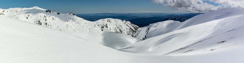
 Leather Barrel Creek – Temptation everywhere
 More Temptation off Rams Head
Day 6: Wednesday 25/07/2012 Around South Rams Head – Dead Horse Gap
Having checked the updated weather forecast and finding it to be colder than forecast at the start of our trip I decided I should do a quick trip to the car to let the handbrake off. Damien joined in but as is often the case on this run the hill was potch marked with ski, snowboard, boot and snowshoe tracks on snow that was starting to set hard in the afternoon shade. Not the best run around.
After four calm nights the wind picked up overnight and morning cloud cover appeared to produce a different feel to the day. On completing a couple of runs in the trees above camp it was mutually concluded we had had a very good run until now and we would depart a little earlier than initially intended, we had seen the best
I was again pleased to be able to do a good part of the drive before dark, that in itself a special treat. A great trip overall, knowing that we had been a little spoilt by four days running of great winter weather and enjoyed it with like-minded people.
Trip stats from the GPS log, excludes all runs without daypack.
 Leatherbarrel Abyss
 Rams Head sastrugi
Clickable icons on a world map which open the related trip report
A detailed, searchable trip list with links to reports, photo galleries and other content
![]()