
Saturday 24/02/2024 Hartz Peak Track Carpark – Hartz Peak Track – Lake Esperance – Ladies Tarn – Hartz Peak
Hartz Mountains National Park, lutruwita / TASMANIA
Palawa Country
Participants: Stephen Davies (Photos), Sue Davies (Report)
We started our day at a campsite in Huonville before we drove about 20 minutes to Geeveston to run the most southerly parkrun in Australia. A volunteer there told us she also worked at the tourist information office and advised us not to walk the Hartz Peak today as it would be too busy.
Max elevation: 1252 m
Total climbing: 486 m
Total descent: -465 m
Average speed: 3.29 km/h
Total time: 04:36:17
I visited the tourist information a bit later and a different person told me it would be fine and we should be right to camp there overnight as well.
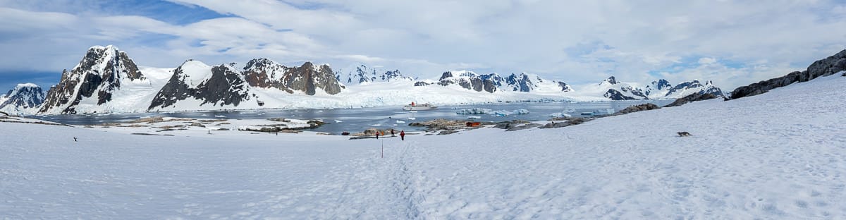
We drove another 20 minutes to Hartz Mountains National Park and the car park for the walk was very busy! We needed to park about 150m further down at the side of the road. Here we had an early lunch before we headed off with a bit of light cloud about.
There are toilet facilities and a day shelter at the start of the walk. Much of the lower sections of the walk have raised boardwalk which we were very thankful for because there was a lot of water around. At times it was gushing underneath us. There is scrubby bush initially and then low heathland with emerging views of the surrounding peaks as we climbed.
The first short side trip was to Lake Esperance. This section of the trail is completely timbered with a platform and seats at the lake edge. This is important to protect the fragile alpine vegetation. Back onto the track we then followed through alpine moors to Ladies Tarn, a smaller but picturesque body of water.

Lichen encrusted boulders on Hartz Peak
From this point the trail becomes quite rocky, necessitating some scrambling and careful foot placement. The trail climbs more steeply and eventually, it becomes a large scree slope. At times it was difficult to pick the best route. Upwards we climbed with great views of Hartz Lake and other smaller tarns. The lichen-coloured rocks and panadus plants (endemic and only found in alpine and wet forest mountains) were a feature at the higher levels. A short scramble saw us at the summit of Hartz Peak. By now, the clouds had cleared but the views were not very crisp. It seemed there was haze from recent bushfires impacting the air quality.
We returned on the same path, satisfied that we had a great day with lots of exercise and great views. This is an excellent half-day walk in Southern Tasmania.
Information on Parks Tasmania signage along the way
Hartz Mountains: Some Points of Interest
National Park History
First Protected 1939. World Heritage 1989
The area of Hartz Mountains National Park has been altered many times since it was first proclaimed a Scenic Reserve in 1939. Parts of the original area of 9308 hectares have been revoked and converted to State Forest and other new parts added, so that the area has now been reduced to 6470 hectares.
The forests in the Picton Valley between here and Federation Peak were the centre of a major conservation battle in the late 1980s. Logging in these forests was the cause of well-publicised protests and arrests at Farmhouse Creek. In 1989 extensions to the World Heritage Area incorporated sections of this forest, as well as the Hartz Mountains National Park.
Death on the mountain
Sydney and Arthur Geeves, 1897
On November 27, 1897, a group of local bushmen encountered a severe storm on the Hartz Range. The party from Geeveston, consisting of an elderly Osborne Geeves, his three sons, Arthur, Richard and Osborne and his nephew Sydney, were returning home from a prospecting expedition near Federation Peak. After a week of rain, gales and snow, the severe blizzard conditions set in as they made their way back home over the Hartz Mountains.
The Geeves family were not new to the south-west and its weather. They had cut the first track from Geeveston to Hartz Mountains. As a result of this track, Hartz Mountains became one of Tasmania’s earliest popular bushwalking destinations. The spin-off for the town of Geeveston was that it would receive its first benefits from tourism. Surveyor Jones reported at the time that “the track from Geeveston to the Hartz Range is, in the season, doing good work by attracting numbers to Geeveston”.
Osborne Geeves’ ill-fated party struggled on over Hartz Pass to Ladies Tarn, but both Arthur and Sydney were faltering and suffering poor vision, and their loads were taken. Within a few hundred metres of the old Hartz Hut (it was located near the present car park), all the party were exhausted and stumbling. Sydney was carried and dragged by Richard to the hut but he died soon afterwards. Arthur was left with his father, and died in his arms with the last words, ‘Don’t leave me, father’. Both had died of hypothermia as a result of prolonged exposure to severe cold.
Today there is a memorial to the two men who perished, close to where they died, only five minutes walk along the Hartz Peak track. Their story remains one of Tasmania’s best-known bushwalking tragedies.
Undaunted by this, the Geeves family continued their exploration of the south-west, going on up to the eastern side of Federation Peak and past Lake Geeves.
Osborne Geeves called this area that he explored the ‘Valley of Horrors’ due to its ‘dense, everlasting interminable scrub’.
The local landscape features, geology, scenic highlights, flora, fauna, indigenous history, white history and other walks in the area (Gemini)
Landscape Features:
Rugged Mountains: The park’s defining characteristic is its dramatic mountain ranges, including the imposing Frenchmans Cap, the highest peak in Tasmania at 1,443 meters. These weathered peaks, sculpted by millions of years of erosion, create a sense of wilderness and grandeur.
Glacial Valleys: U-shaped valleys, carved by glaciers during past ice ages, like the Cradle Valley and Lake St Clair, showcase the erosive power of nature and cradle serene lakes and lush vegetation.
Temperate Rainforests: Towering rainforests, dominated by myrtle beech and celery pine, cloak the mountain slopes and valleys. These ancient forests provide a cool, green haven and habitat for diverse plant and animal life.
Waterfalls and Lakes: Cascading waterfalls, like the powerful Ballroom Forest Falls and the serene Waldheim Falls, add to the park’s scenic beauty. Pristine lakes like Lake Rodway and Lake King William offer opportunities for reflection and tranquility.
Geology:
The dramatic landscapes of Hartz Mountains National Park are a testament to its ancient geological history. The mountains are composed of dolerite, a hard rock formed from cooling lava flows approximately 180 million years ago. Subsequent glacial activity sculpted the valleys, leaving behind U-shaped landscapes and creating fertile ground for vegetation.
Scenic Highlights:
Cradle Mountain Summit Hike: Ascend the challenging yet rewarding Cradle Mountain summit walk, enjoying panoramic vistas of surrounding peaks, glacial valleys, and ancient rainforests.
Lake St Clair – Cradle Valley Circuit: Embark on a multi-day hike along the renowned Lake St Clair – Cradle Valley Circuit, traversing diverse landscapes, encountering waterfalls, and immersing yourself in the wilderness.
Waterfall Walks: Discover hidden waterfalls like the Ballroom Forest Falls or the cascading Waldheim Falls along shorter walking tracks, perfect for capturing the power and beauty of these natural wonders.
Local Flora:
The diverse habitats within Hartz Mountains National Park support a rich tapestry of plant life:
Temperate Rainforests: Towering trees like myrtle beech (Nothofagus cunninghamii), celery pine (Phyllocladus aspleniifolius), and sassafras (Atherosperma moschatum) dominate the rainforest canopy, while the understory boasts ferns, mosses, and colourful fungi.
Alpine Heaths: Above the tree line, windswept alpine heaths, dominated by low-growing shrubs like mountain pepper (Tasmannia lanceolata) and cushion plants, showcase resilience in harsh conditions.
Riparian Vegetation: Along riverbanks and around lakes, reeds, rushes, and sedges thrive, providing habitat for aquatic insects and birds.
Local Fauna:
Keep your eyes peeled for Tasmania’s unique and diverse fauna while exploring Hartz Mountains National Park:
Mammals: Spot elusive Tasmanian devils, pademelons, and wallabies amongst the vegetation. Look out for shy platypus in the waterways and listen for the calls of echidnas at dusk.
Spot elusive Tasmanian devils, pademelons, and wallabies amongst the vegetation. Look out for shy platypus in the waterways and listen for the calls of echidnas at dusk.
Birds: Diverse birdlife fills the park with song. Listen for the calls of colourful parrots like the green rosella (Platycercus callodes) and the eastern rosella (Platycercus eximius), as well as honeyeaters, kookaburras, and raptors like wedge-tailed eagles (Aquila audax) soaring through the skies.
Reptiles and Amphibians: Basking lizards and skinks might be spotted on sunny rocks, while frogs like the spotted tree frog (Litoria punctata) croak near water bodies.
Indigenous History:
The traditional lands of the Palawa people encompass the Hartz Mountains National Park area. Evidence of their long connection to the land can be found in middens and stone artefacts scattered throughout the region. The Palawa people hold a deep spiritual connection to the mountains, lakes, and rainforests, considering them places of great significance in their cultural traditions.
White History:
European explorers first arrived in the area in the early 1800s. The harsh environment initially discouraged settlement but later saw attempts at mining and grazing. Conservation efforts gained momentum in the early 20th century, culminating in the declaration of the Hartz Mountains National Park in 1951. Recognizing the ongoing cultural connection of the Palawa people to the land is vital for respecting the park’s rich heritage.
Clickable icons on this world map will open the related trip report
A detailed, searchable trip list with links to reports, photo galleries and other content
![]()