
20/09/2017 – 23/09/2017 Guthega – Mt Twynam – Pounds Creek – Snowy River
Kosciuszko National Park, NSW
Ngarigo country
Distance: 56 km Total Ascent: 3,980 m Total Descent: 3,980 m
Time: 21 hours
Participants: Stephen Davies (Photos, Report)
Guthega provides relatively easy access to a lot a great skiing locations. Cars can be left in the overnight carpark about 1km from the resort. This trip follows the road through the village and before crossing the foot bridge across Blue Cow Creek and continuing south west a couple of hundred metres above The Snowy River until reaching Illawong Hut. Below the hut is a swing bridge with provides easy access to The Great Dividing Range and all it has to offer.
Day 1: Wednesday 20/09/2017 Guthega – Mt Twynam
Max elevation: 2292 m
Total climbing: 1071 m
Total descent: -888 m
Average speed: 4.71 km/h
Total time: 06:42:40
An early start from home yesterday saw me arrive at Guthega Resort at 3:00pm. The weather forecast had predicted clouds clearing and winds to ease for the afternoon. That’s not what I found in front of me.
Winds were still up and the clouds were hanging in low, at best the bottom third of the range was visible. As I now had less than 3 hours until sunset I made the call to delay my start until Wednesday. A pleasant night was spent camping at Island Bend. First I’d noticed that there are now several areas closed off with “Asbestos” signs.
Wednesday morning saw clear skies and a light breeze. After negotiating some of the intricacies of my new Aarn backpack I was off from the overnight carpark.
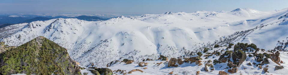
I set a very sedate pace as it was easily the heaviest pack I had carried this year. After record breaking snowfalls in early September the cover was superb.
My new Rossignol Sky 7 skis (with patternless base – no grip without skins) were on their first backpacking trip, so I had a few things to figure out. Walked the first short uphill snow-slope to avoid the need to stop to put the skins on, with the rigmarole of taking skis and pack off avoided.
A short downhill ski to the first bridge across Blue Cow Creek, walk over the bridge and then skins on for the climb out. The skins stayed on until I reached camp a couple of hours later.

The swong bridge across the Snowy River below Illawong Lodge
The ski through the trees above Guthega Pondage and along the Snowy River had ample snow cover as expected. Once to Illawong swing-bridge the real climbing began. As I was feeling the load and there was more wind about than I had expected I set up camp at 1825m alongside a patch of snow gums.
After lunch I proceeded to climb Mount Twynam via the flank of Little Twynam. This was much less pleasant than anticipated. The wind was strong at times and the snow heavily windblown and icy in patches. Numerous times on the climb the full-length skins slide backwards, making it tough work.
I met one other person on top, he was one of a party of eight staying at Illawong Lodge. Earlier I spoke to two guys skiing out after camping Tuesday night. They failed to even see Twynam, or any other peaks, let alone climb them and had white conditions and solid wind all day. Glad I was at Island Bend last night.
After cautiously skiing down the northern side of Twynam through some rough and very wind affected snow I made my way back to the tent, picked up all my empty water bottles and headed down Twynam Creek to look for some open water. A much better run was enjoyed here and exposed water was found, bottles filled and carried back to camp. Much better than melting snow!
A moonless night saw the tripod out and me trying to figure out the limitations of some time-lapse accessories, with some progress being made and a few star shots taken for good measure.
Timelapse from our along Twynam Creek campsite
Day 2: Thursday 21/09/2017 Twynam Creek – Pounds Creek
Max elevation: 2055 m
Total climbing: 1320 m
Total descent: -1309 m
Average speed: 5.38 km/h
Total time: 06:51:50
After a restless night’s sleep in a noisy, flapping tent being whipped up by an endless string of wind gusts I resolved to ensure there was maximum tension on all guy ropes tonight. A slow start ensured as the wind remained and the snow was still firmly frozen even after two hours of exposure to sunlight.
Embarking onto the slopes around 10am I did two runs of Twynam Creek. Whilst collecting my daypack which I had placed in a tree at the bottom of the run I had my only fall of the day. The skis slipped and I found myself being knocked to the ground and ending up under a awkward low lying branch.
A call from Robyn and Rick last night had us attempting to met up somewhere. So after a couple of morning calls I found myself heading over towards Pounds Creek. Whilst waiting three more runs down to the creek were enjoyed.
Despite a couple more “where are you” calls we still had trouble catching sight of each other. When we did we descended into a side creek to get out of the wind for lunch.

Rick skiing near Pounds Creek
After sidling about 1km further upstream I found it wasn’t working too well to be touring with others who had patterned bases on their skis, so we headed off in different directions with different objectives. Robyn and Rick headed up and over Tate East Ridge so as to return to Guthega whilst I did three runs from below Mann Bluff into Pounds Creek. Now just after 3pm it was time to head back to camp after an awesome day out. The snow was great after about 11pm and keeping off the peaks I avoided what seemed to be most of the forecast winds for the day.
Day 3: Friday 22/09/2017 Twynam Creek – Foremans Crossing
Max elevation: 2109 m
Total climbing: 1348 m
Total descent: -1351 m
Average speed: 5.58 km/h
Total time: 06:21:05
With warmer overnight temperatures the snow started softening a little earlier this morning so I was off by 9:30am. A couple of runs to the top of Twynam Creek found me working hard against a stiff breeze for each climb. It certainly felt in excess of the forecast 55km/h wind speed. The snow was already soft and slow upon reaching the snow gums at the bottom of my run.
Plan B was subsequently implemented. This was to ski to the bottom of the creek and then head up the Snowy River to Foremans Crossing.
The loss in altitude resulted in shelter from most of the wind. Twynam and its flanks obviously providing a really good windbreak from the westerlies.
Despite the very gradual gradient along the Snowy River my patternless ski required the use of skins. This wasn’t always the best option as skins don’t slide all that fast on the short downhill sections. I kept near the river and took lots of photos, there were still lots of snow covered rocks in the river and chunks of ice drifting downstream.

The Snowy River at 1670m
Having passed Club Lake Creek and traversed the ridge just beyond, Foremans Crossing was in view. It was remarkable to see ski tracks across the still complete snow-bridge across both the Snowy River and Club Lake Creek.
The return was slower than hoped for with the snow wet and heavy after the temperature reaching 16 odd degrees. There are some fantastic slopes along this stretch of the river. Treeless and a with a variety of gradients to keep most telemarkers very happy for a long time. Particularly notable being the valley about 500m south of Twynam Creek. This opens out into a large bowl just beyond a few snow gums and sits due east of Little Twynam. It should be a great spot with good protection from westerlies and when clouds are hanging around the higher peaks.
The tour was completed by cutting the corner, so instead of heading directly to Twynam Creek and following it up I
aimed directly for camp and saved a good distance. Back near camp the wind “returned”. A very quiet evening followed, my poor old body requiring a good rest. The forecast for tomorrow isn’t terribly good, wind to 70km/h with some afternoon rain and chance of thunderstorm. Looks like time to pack up and leave first thing in the morning.
Day 4: Saturday 23/09/2017 Twynam – Guthega
Max elevation: 1972 m
Total climbing: 259 m
Total descent: -448 m
Average speed: 7.34 km/h
Total time: 01:36:22
Awoke to a gentle breeze and clear blue skies. Feely a little fatigued and noting the days forecast resolved to be home before dark. So was lifting my pack and putting on skis by 9:30am for the return. At this point a huge black cloud had rapidly snuck over the mountains from the west and convinced me I would be getting very wet before reaching my car. So I was off, quickly paralleling down towards Illawong suspension bridge.

Threatening clouds
Once over the bridge the skins were on and I was snaking my way through the tress above and along the Snowy River back to Guthega. I encountered two parties heading out, with intensions of summiting Mount Twynam or nearby ranges. Not my choice with winds building to forecast 90km/h in the afternoon!
Anyway I made rapid progress to the village on great snow cover. By the time I arrived the threatening cloud had dissipated and it was all blue skies. Maybe I could have got away with a few morning runs.
The drive home was anything but smooth. A grass fire at Paddys River near Marulan had crossed the Hume Highway at traffic was stopped and turned around in both directions. I was forced to return to Goulburn and get back to the coast via Tarago and Nerriga, adding about three hours to the trip. Should have taken some morning ski runs!
Clickable icons on a world map which open the related trip report
A detailed, searchable trip list with links to reports, photo galleries and other content
![]()