
Thursday 7/03/2024 Rocky Cape Road Track – Cathedral Hill – Postman’s Pass – Rocky Cape Inland Track – Saddleback Hill – Tinkers Lookout Track – Tinkers Lookout – Blandfordia Spur – Blandfordia Hill – Rocky Cape Coastal Route – Cathedral Rocks Track – Cathedral Rocks
Rocky Cape National Park, TASMANIA
Tangdimmaa Country
Participants: Stephen Davies (Photos), Sue Davies (Report)
Another stunning morning with a beautiful sunrise over the ocean greeted us from our campsite in Boat Harbour Beach. We planned to explore the nearby Rocky Cape National Park over the next two days. We decided to look at the western side first.
Max elevation: 295 m
Total climbing: 703 m
Total descent: -665 m
Average speed: 3.34 km/h
Total time: 05:05:42
It was a 20-minute drive to the start of the walk along Rocky Cape Road. This area has been enjoyed by Tasmanian Aboriginal people for thousands of years. There are vast cave middens and they remain culturally, spiritually and recreationally important to today’s Aboriginal community.
The rocks of Rocky Cape are among the oldest in Tasmania, they are Precambrian quartzites that have been lifted and folded producing amazing contorted patterns. The vegetation on this walk was mainly low coastal heath which looked very dry given the lack of recent rainfall.
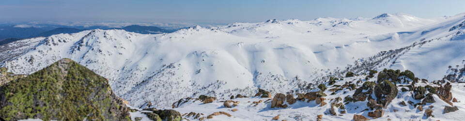
We climbed steadily along the sandy track to Cathedral Hill, Saddleback Hill and then Tinkers Lookout. To the west, we could see the smoke of a contained bushfire at Crayfish Creek which had been burning for the last few days. Luckily for us, the wind was favourable so the smoke didn’t bother us.
The coastal views were stunning and panoramic with white sandy beaches and aquamarine water. We then followed the Blanfordia Spur across and through a grove of taller Melaleuca to the beach. We had thought we might walk for a while along the beach but the sharp uneven, rocky surfaces made us think again. We found a spot for a sneaky swim which was delightful. We had some lunch before returning to the trail and onto Cathedral Rocks. More beautiful coastal rock formations with crystal clear water!

Cathedral Rocks from Cathedral Rocks Track
Back on the track we had glorious views of Blue Rocks Point and Burgess Cove. It did remind me of the scenery on the Cape to Cape walk in Western Australia, it was so beautiful. We saw a few skinks and birds of prey hovering overhead but not much other wildlife. After descending Cathedral Hill we were back at the car and in search of afternoon tea. However, the cafe closed at 3:00pm so we were out of luck today!
This was a lovely half-day or shorter day walk and is best when the weather is not too hot. We only saw two other people the whole day so we mostly had the park to ourselves!
Information on Parks Tasmania signage along the way
fire – patrula
Over the countless generations during which we occupied this land. Aboriginal people managed food resources by regular burning in a mosaic pattern. This ensures a continuing variety of plants: parrakaa [orchids) and tabelak [banksia] flower only after fire. Other food plants such as yamana (grass trees) send out tender new growth that is delicious to eat.
Animals find the new growth just as tempting, so periodic burning attracts quaibaa (wombats) and hootenaa (wallabies) onto our land.
We also harvested food from the sea, building fish traps in the shaltows and diving for makranya (abalone] in the deeper waters.
RESPECT FOR THE LAND IS ALWAYS THE GUIDING PRINCIPLE.
Tasmanian Aboriginal people have a continuing respect and love for this land and maintain their links through regular visits. Spread widely across this state, we are redeveloping our land management and heritage in many places, including the Rocky Cape area.
Traditional values of land, sea and waterways and keeping our culture alive are central to the Tasmanian Aboriginal identity.
Cave – puwatina
Within this national park are many caves, which we believe were carved out by the ancestor spirits.
The Rarerloihenaa people occasionally lived in these caves, maintaining a connection with the creation spirits.
WE ASK THAT YOU SHOW RESPECT by not entering the caves, and not disturbing the land around them.
Please feel welcome to explore Tangdimmaa You can take coastal or inland walks, ranging in length from 20 minutes to a full day.
The local landscape features, geology, scenic highlights, flora, fauna, indigenous history, white history and other walks in the area (Gemini)
The park itself is situated along Tasmania’s north-west coastline and is renowned for its dramatic coastal scenery, diverse heathland vegetation, and unique geological features.
Landscape Features and Geology
Dolerite cliffs and columns: The route traverses sections characterised by impressive dolerite cliffs and columns. Dolerite is a dark-coloured and fine-grained igneous rock formed by volcanic activity.
Rocky headlands and bays: The coastline alternates between rocky headlands and sheltered bays, creating a visually diverse landscape.
Rolling hills and valleys: Inland sections comprise rolling hills and valleys covered in heathland vegetation.
Scenic Highlights
Panoramic coastal vistas: The walk offers spectacular views of the coastline, with crashing waves, dramatic cliffs, and offshore islands.
Cathedral Rocks: These dolerite columns, resembling a cathedral, are a significant geological feature and provide a photogenic vista.
Tinkers Lookout: This vantage point offers panoramic views of the surrounding landscape, encompassing coastline, heathlands, and mountains.
Rocky Cape Coastal Route: This section of the walk provides a contrasting experience, traversing sheltered beaches and rocky platforms along the coastline.
Local Flora
The vegetation along the circuit varies depending on location:
Coastal heath: Exposed coastal areas are dominated by low-growing heath vegetation adapted to wind and salt spray. This may include species such as coastal rosemary (Leucopogon virgatus) or heath banksia (Banksia ericifolia).
Saw banksia woodland: Inland areas support stands of saw banksias (Banksia serrata), with other shrubs such as tea tree (Melaleuca spp.) or melaleucas (Melaleuca ericifolia) potentially present.
Grasslands: Some sheltered areas may support pockets of native grasslands with wallaby grasses (Danthonia spp.) or kangaroo grass (Themeda triandra).
Local Fauna
The fauna of the Rocky Cape circuit reflects the diverse habitats present:
Birds: Seabirds such as gulls (Laridae family) or mutton-birds (Puffinus carneipes) can be seen along the coastline. Raptors like wedge-tailed eagles (Aquila audax) may also be sighted.
Mammals: Eastern grey kangaroos (Macropus giganteus) and pademelons (Thylogale spp.) may be encountered in open areas. Brush-tailed possums (Trichosurus vulpecula) and echidnas (Tachyglossus aculeatus) may be present in woodlands.
Reptiles: Snakes such as tiger snakes (Notechis scutulatus) are present in Tasmania, so caution is advised while walking.
Indigenous History
The palawa people are the traditional custodians of this land. Evidence suggests Aboriginal Tasmanians frequented the Rocky Cape area for hunting, fishing, and resource gathering. Middens (shell and bone scatters) found in the park indicate their connection to this place. Further consultation with Tasmanian Aboriginal people is needed for a deeper understanding of their relationship with Rocky Cape.
White History
European settlement in the north-west region began in the early 19th century. Land use included grazing and some quarrying activities. Rocky Cape National Park was proclaimed in 1978, recognising the park’s natural and cultural values. The walking tracks and viewing platforms allow visitors to appreciate the park’s beauty while minimising environmental impact.
Other Nearby Walks
Rocky Cape National Park offers a range of walking tracks beyond the circuit described:
The Neck Circuit: Hike through heathland and coastal forests with views of Bakers Beach.
Doone Falls Track: Take a longer walk to Doone Falls, a cascading waterfall within the park.
Lee Archer Cave Track: Explore a sea cave with evidence of Aboriginal habitation.
This looped walking circuit within Rocky Cape National Park provides a comprehensive experience of the park’s diverse landscapes, geology, and flora. From dramatic coastlines and heathland vistas to historical significance, the walk offers a glimpse into the natural beauty of Tasmania’s north-west.
Clickable icons on this world map will open the related trip report
A detailed, searchable trip list with links to reports, photo galleries and other content
![]()