
5/10/2018 – 11/10/2018 Guthega – Mount Twynam – Mount Anderson – Watsons Crags – Little Twynam – Crummer Spur – Twynam Creek
Kosciuszko National Park, NSW
Ngarigo country
Distance: 80km Total Ascent: 5,270m Total Descent: 5,270m
Time: 80 hours Track Info
Participants: Monika (4 days), Melinda Brouwer (4 days), Stephen Davies (Photos, Report), Stephen Poole
Day 1: Friday 5/10/2018 Guthega – Mount Twynam
Max elevation: 2143 m
Total climbing: 985 m
Total descent: -515 m
Average speed: 4.43 km/h
Total time: 04:42:04
Having spent yesterday indoors at Christiana Lodge in Thredbo due to rain showers and low cloud, it was disappointing to wake to the sound of more rain on the roof. Looking outside also revealed lots of low cloud and fog.
All four of us met at Jindabyne at 8:30am as planned. With clouds also low around Jindabyne, we headed to a local cafe for a while. With no clearing, we then adjourned to the Canberra Ski Club Lodg,e of which Monika is a member. After lunch there we noted the cloud was starting to lift slowly. It seemed that finally we should drive up to Guthega and try our luck.
Our timing was very good, as when we arrived, the rain had stopped. We managed to get away at about 12:30pm. Having been above zero for a couple of days, the snow was now soft and wet. Whilst approaching Blue Cow Creek footbridg,e Stephen broke through this weakened snow and had one leg disappear all the way up to his groin.

Stephen is breaking through to the groin
The walking track was then followed until we had passed the trees with only a couple of snow-covered sections to cross. From there, we were able to mostly ski to the Illawong suspension bridge.
Now heading up the hill to the west, we had good cover with only a couple of short sections of grass to cross or ski around. We made steady progress, stopping infrequently, as there was a cold breeze blowing providing motivation to keep moving.
Once up to Pounds Creek, we had a very short stop before continuing up and around the northern side of Mount Twynam before reaching our targeted campsite at 2100m on Mount Twynam’s northern ridge. After reaching the higher ground, the wind had picked up significantly and was very cold.
Once at camp, Stephen and I dropped off our resupply loads before returning to the gear stash we had left out amongst some rocks on the ridge above Pounds Creek at the end of our last trip. We had returned to camp a second time by 5:00pm. Coming down Mount Twynam, we both noted a unique snow surface as we went. The now and previously frozen surface had been eroded into a honeycomb-like matrix of icy tentacles by the previous day’s light rain; neither of us had ever skied on anything like it before. As I arrived back at camp the second time Monika and Melinda were leaving. They had decided the wind was too strong for the tents they had brought with them and were moving down towards the adjacent creek for some shelter.
Stephen and I remained as planned, but spent much longer than usual getting our tents up. This involved wrestling with them as they were being blown around vigorously one way and then another in the strong wind.
Needless to say, it wasn’t a night for socialising as we all quickly disappeared into our tents to warm up. We were howeve,r treated to a colourful sunset as we did.

Sunset from Twynam’s northern spur
Day 2: Saturday 6/10/2018 Mount Twynam – West of Mount Anderson
Max elevation: 2144 m
Total climbing: 1075 m
Total descent: -1076 m
Average speed: 5.66 km/h
Total time: 06:07:33
After the late setting up of camp and the delayed dinner last night, it took a while to get going this morning. Monika and Melinda turned up from their lower campsite around 9:00am before heading off to explore the hills and valleys to the west of Mount Anton. Once Stephen and I got moving, just after 10:10am the snow had thawed nicely, and we cranked out plenty of turns as we descended directly down along the ridge below where we were camped.

My tracks down Mount Anton
Before heading up along the small creek heading east away from our ridge, we collected some water from the open creek. Once back to the top of the cree,k we traversed cross-country over patches of snow and grass to where we had previously seen Monika and Melinda skiing on Mount Anderson’s western ridge. They were now long gone, having had a good hour head start and taking a more direct route to get there. Stephen and I completed a descent off to the north into Verandah Creek before returning to the top of the hill and doing another run to the south down along a small creek towards Watsons Creek far below.
Returning to our packs on the ridge above, we ate lunch before heading back to camp. Pausing to complete a couple of panoramas, Stephen ended up a ways ahead of me along the route we had taken in the morning. I instead headed over and into Pounds Creek and followed it back up to Mount Twynam. With my tent in sight, I descended to the creek below near the girl’s tent to collect water from an open section of the small creek before climbing back up to camp.
It was still pretty cold in the breeze, so again we all retired to our tents for the rest of the evening, although we did briefly gather again to watch the sunset from the ridge.

Sunset over Watsons Crags from Mount Twynam’s northern spur
Day 3: Sunday 7/10/2018 Mount Twynam – Watsons Crags
Max elevation: 2188 m
Total climbing: 893 m
Total descent: -895 m
Average speed: 7.10 km/h
Total time: 06:47:55
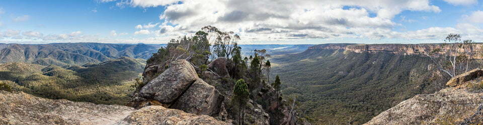
We all four departed camp together about 10:00am with a very cool breeze blowing as we climbed a little higher on Mount Twynam before traversing around towards Watsons Crags. It was a beautiful, clear day, and the snow was just starting to soften as we progressed.
We took our time and made the most of the many magnificent photo opportunities as we proceeded to cross the Crags’ entire snow-covered extent to its western edge. We did much the same on the return, looking over the other side.

Melinda on Watsons Crags ridge
From here, Monika and Melinda continued on towards Blue Lake whilst Stephen and I had lunch at the top of Watsons Creek. After lunch, we completed three very cruisy runs down the southern side of Tenison Woods Knoll (the first knoll) on Watsons Crags. Despite the great attraction of skiing the much more dramatic northern slopes, we both resisted, as we knew what a long, hard slog back up it would be.
After returning to our sheltered lunch spot for a snack and collecting our packs, we were off to summit Mount Twynam to again savour the awesome views. Some late afternoon shadows providing dramatic relief to the landscape. Along the way, we crossed paths with Melinda and Monik,a who were now heading back to camp.
From the top, Stephen headed for a run down Mount Twynam’s eastern face as he had not done it before, whilst I headed back down the ridge towards camp with a run to the bottom in mind. Stephen was very disappointed and a little challenged on his run as it had started to freeze in the shade. I, on the other hand, stopped at our campsite because the ridge had received too much afternoon sun and the snow had become slow and sloppy. Neither of us had picked the best aspect for the time of day.
A water collection sortie to the creek below was the last of the day’s skiing. Later, we enjoyed yet another colourful sunset before again retreating to our tents to escape the very cool breeze which has spent almost as much time here as we have on this trip.

Melinda watching sunset over Watsons Crags
Day 4: Monday 8/10/2018 Little Twynam – Crummer Spur – Blue Lake – Mount Twynam
Max elevation: 2187 m
Total climbing: 873 m
Total descent: -874 m
Average speed: 6.46 km/h
Total time: 05:46:40
Monika and Melinda headed out today by following the ridge towards Mount Tate before crossing Tate East Ridge and descending down to Guthega River. Meanwhile, Stephen and I headed up over Mount Twynam again before a short climb and traverse around Little Tywynam onto Crummer Spur. This provided us with a nice but fairly slow run down the snow covered northern side of Crummer Spur to the Snowy River.

Stephen skiing up alomg the Snowy River
From here we rounded the end of the spur and casually started heading up Blue Lake Creek, shortly after having morning tea on a grassy patch. Not having checked the map or having gone up this way anytime recently I didn’t realise that I actually branched off following “Carruthers” Creek instead of Blue Lake Creek. Blue Lake Creek where it joins “Carruthers” Creek forms a more subtle creek line. We still had a nice ski along our detour and got really good views over Blue Lake as we approached it from above to its west instead of up along Blue Lake Creek.
A short descent had us down onto the snow covered shoreline of Blue Lake. At the lake’s outlet we again stopped for another break. Numerous photos from different points of view along the way had this area well covered.

Blue Lake
From Blue Lake, we followed Blue Lake Creek up to its source to the west of Mount Twynam before our final short descent back to camp. A relaxed afternoon followed by the return of the cold breeze that had persisted throughout our stay at this campsite. This was in stark contrast with the at times, very warm and calm periods we had experienced today after leaving Crummer Spur until again reaching the western side of Mount Twynam. The breeze wasn’t reaching the eastern side of the range at all.
Monika’s Facebook Post (with permission)
“We joined Steve D on his Twynham tops tour for four days and three nights. Instead of camping at his preferred windy and exposed spot overlooking Watsons Crags, we settled on a slopey spot 50 m below a big cornice, adjacent to running water, and more importantly, out of the ever-present wind. We did two great day tours – the first out to Mt Anderson and a lesser peak, then over to the Mt David ridge where we could see a weather station below; the second out on the top of Watsons Crags and then back to Blue Lake, coming out near Little Twynham. On our final day, we scooted back to the car via the tops, staying as much as possible on snow on the eastern slopes until we got to East Tate Ridge where we declined the temptation of climbing Mt Tate and, instead, ‘hooned’ (or survived) skiing on our skinny skis and packs off Gills Knob to the little foot bridge across Guthega Creek.”
Day 5: Tuesday 9/10/2018 Mount Twynam – Twynam Creek
Max elevation: 2143 m
Total climbing: 416 m
Total descent: -697 m
Average speed: 8.87 km/h
Total time: 04:07:18
Time to move camp. With the weather forecast indicating showers for this afternoon and into tomorrow and with other people planning to join us from Thursday we had decided to drop down lower onto the other, eastern, side of the range. We were yet again greeted with a cold breezy but sunny morning but today there were also a few more clouds hovering about.
In no real hurry we headed off around 10:00am for the trivial climb before we could traverse around to the northern side of Mount Twynam. Then a short descent on nice spring snow with a few carefully managed parallel turns under the weight of a full pack to cross the very top of Pounds Creek. From here we followed the northern side of Twynam Creek to our campsite amongst a group of snowgums on a flat bench-like platform on an otherwise respectable gradient hillside. Todays 3km move was complete in just under an hour.
Stephen selected a flat grassy spot under some trees for his tent whilst I levelled a site on the snow nearby to the east of the trees. Stephen was concerned that the many local crows would prevent any sleeping in. By this stage it was heavily overcast and felt like the rain was near.

My campsite near Twynam Creek
After lunch I wandered off and found water in Twynam Creek not too far away and almost at the same altitude as our tents. On returning those 3L to my tent I continued on and skinned it up to the top of Little Twynam for a run, followed shortly after by Stephen. As I was about to start my descent light rain began, so after just one telemark run we were back into our tents for the rest of the day. At this point the updated weather forecast warned of potential thunderstorms for the early evening, a warning coming too late to act on. Fortunately for us no thunderstorms eventuated. With three bar 4G phone reception and a fully charged battery pack there were plenty of entertainment options available and this blog to continue writing and edit.
Day 6: Wednesday 10/10/2018 Twynam Creek
After a night of rain and snow my tent was shedding accumulated snow as I stirred. The cloud base was below camp and the Snowy River was not always visible below us. With very wet snow and rain falling, along with 100% humidity it was looking very much like an “indoors” day.
The light westerly wind eased during the middle of the day affording me the opportunity to get out and wander around our campsite for a while. With some nice snowgums nearby I also took a few photos. Beyond that it was back into the tent for the rest of the day and again editing my ski trip posts!

Snowgums around our campsite near Twynam Creek
Of special mention: My Jetboil Mini stove has just tonight emptied a 220g gas canister that was started at the beginning of my last six day trip. In all enough gas for ten main meals, twenty hot drinks, hot water for breakfast cereal each day and a little snow melting to complement my water supply! Well done Jetboil, the heat exchange system really does greatly improve fuel efficiency.
Day 7: Wednesday 11/10/2018 Twynam Creek – Guthega
Max elevation: 1829 m
Total climbing: 579 m
Total descent: -578 m
Average speed: 4.60 km/h
Total time: 08:54:20
Again overcast, we were heading out with one day’s supplies remaining as we meeting up with Mike Parkinson in Jindabyne at 12:00pm to ski back in for our “next” trip in the afternoon. With camp left set up we only required our packs with our rubbish and waste for our “big day out”.

Stephen departing our Twynam Creek campsite
A quick ski back down to Illawong bridge had us on the other side of the Snowy River in about 30 minutes. Then around another hour of skiing and walking had us back the car.
From the until our afternoon return to camp saw us being able to empty the contents of our poo tubes (actually bags) down the Island Bend long drop toilets, have a shower, organise supplies for a few more days and enjoy eating out for lunch.
A detailed, searchable trip list with links to reports, photo galleries and other content
![]()
HI steven
just wanted to thank you for fantastic info and pics on ski touring the kosi park lands
im just getting back into touring and backcountry adventuring after many years not sking
im now 57 but wish i could do this evry week in winter, planing a couple of nights up on tywnam and reading this is really good. im solo at present but looking for a nice sunny window, the weater at the moment looks pretty calm, well thanks for all you posts
regards Ben
Hi Ben
be aware that backcountry conditions at the moment are dangerous due to boilerplate ice, due to lack of snowfalls. I was telemarking at Perisher last week and multiple sources reported the same difficult, treacherous conditions.
Hi Stephen
Thanks for the update,
looking at late august / sep at the moment, waiting for a front to come in and top up the cover,
i was up at guthega trig a few weeks back the day was stunning but the were some big areas of ice up top that i avoided.