
08/04/2018 – 10/04/2018 Hannels Spur – Moiras Flat – Muellers Peak – Dead Horse Gap
Kosciuszko National Park, NSW
Ngarigo country
Distance: 37km Total Ascent: 2870m Total Descent: 1870m
Time: 18 hours
Participants: Damien Aggio, Stephen Davies (Photos, Report)
Hannels Spur runs up from the Geehi River to the West of the Main Range up to the highest peaks in Australia. This 1,800m climb is the biggest in Australia.
Damien and I had both harboured ambitions to complete this walk for some time. However, heavy regrowth after the 2003 bushfires that devastated the area meant there had been some serious scrub bashing along the route for some time. Fortunately for us we had some inside information that National Parks were planning a work party early in 2018 to clear some of the worst of this regrowth. An opportunity too good to miss had now presently itself.
Day 1: Sunday 8/04/2018 Doctor Forbes Hut – Moiras Flat
Max elevation: 1534 m
Total climbing: 1675 m
Total descent: -598 m
Average speed: 2.55 km/h
Total time: 06:59:57
After a very cool but pleasant overnight camp beside the Geehi River in the camping area next to Geehi Bridge we drove back south about 800m to the turnoff for Doctor Forbes Hut track, our starting point which we reached at 10:0am. Damien managed to rock hop across the Geehi River, whilst I took the conservative approach, donning my Crocks and walking through a short stretch of shallow water.
After checking out Doctor Forbes Hut and questioning why there was so much mortar between the stones of the walls we followed the track towards the south for a short warm up on a flat section before meeting the foot of Hannels Spur. From here we had an 1,800m ascent to look forward to!
The track, or at times probably better described as a tagged route, was quickly into the trees and scrub and trending upwards. It is a relentless climb, at times gentle and even flat for short sections but also steep in a couple of sections. Being covered in leaf litter, fallen branches and the occasional fallen tree the going is slow and at times the footing can be tenuous.

Damien climbing Hannels Spur Track
The route is marked by frequent, usually pink, tape which appears at a variety of heights from on the ground to around 2m up on branches and concealed within shrubs. The mostly fluorescent pink tags vary from brand new to very old, tattered and extremely small remnants. There are also the occasional metal triangular markers on some of the larger trees, mostly around 2m up.
Despite widely varying spacing between these tags, between a couple of metres to out of sight, we largely kept on route. However, on two occasions large fallen trees caused us to get off course, so we ended up doing our own route finding for a little over a kilometre. Thanks to Feral Kaza, whose published route we had printed, we were able to head in the right direction and eventually pick the track back up on both occasions. Please note it would be a little easier and quicker to keep to the defined route, if you can find it!
Deliberately keeping to a slow and steady pace throughout the day still had us at Moiras Flat by 4:00pm. We were very pleased with the track clearing that had been completed below Moiras Flat, I’m sure it saved us a lot of time and without doubt considerable effort as well. As the sign to the creek and your water supply has collapsed, it should be noted that you continue a little further along the main track (east) before another water sign leads you off to the north along the now cleared route to very small creek. You may need a cup to collect the water and probably should not rely on it after extended dry spells.

Damien at camp at Moiras Flat
We were blessed throughout the day with clear skies and only an odd puff of a breeze.
Sunday evening was dead calm and crystal clear. With a late rising moon it was perfect for laying back and admiring the full glory of the Milky Way and catching several shooting stars and many passing satellites. A great finish to a very satisfying day having climbed over 1,100m.
Day 2: Monday 9/04/2018 Moiras Flat – Muellers Peak
Max elevation: 1980 m
Total climbing: 802 m
Total descent: -347 m
Average speed: 2.30 km/h
Total time: 07:21:42
Our relaxed style had us leaving Moiras Flat at 10:00am. Not too far out of camp the track steepens for a couple of hundred vertical metres before becoming less inclined. We were again very appreciative of clearing work that has been done above camp.
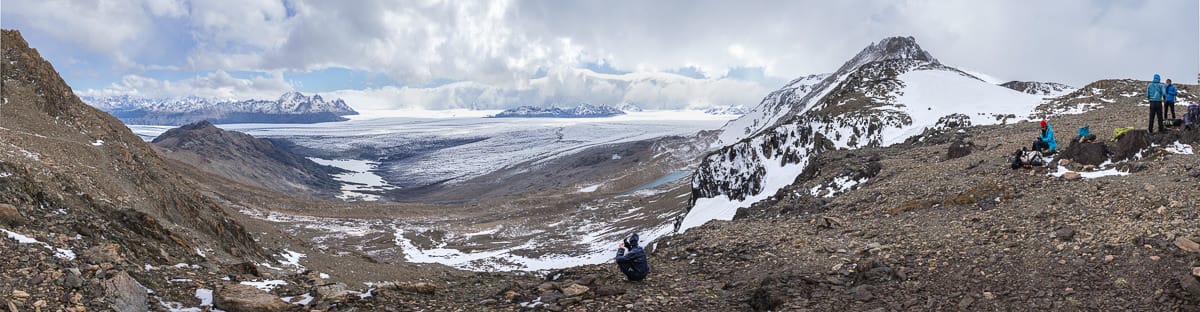
The flora transitions rapidly from the tall tree, shady forest we had been in so far to low alpine heath amongst numerous dead, light grey snow gum skeletons. Here the taped route is replaced by small metal triangles on larger trees. Now being above the tree line extensive views quickly reveal themselves. Our first sighting of Jagungal and the North-Western faces of the Abbott Range occurred at about 1,700m.

Stephen reaching the treeline at around 1700m
The first rock cairns appear at around 1,800m, these dominate the route marking for the rest of the day but there are also a few tape markers. Just so we can fully appreciate the clearing work done we now get to pass through a few uncleared sections of knee height alpine heath above 1,840m, I’m glad I have my gaiters on and despite Damien’s polite request to borrow them, I selfishly declined.
Selective growth clearing continues high up onto Abbott Ridge. Once over the highest point the route down to Wilkinsons Creek passes across gently undulating open heath, the route being marked by occasional rock cairns, which are easily missed and there is no obvious track across this section. What should be noted and looked out closely for are the few very well hidden thigh deep holes along the way, they could easily be leg breakers.
The Wilkinsons Creek crossing is marked by a small rock cairn and consists of a series of closely spaced boulders. It is be very easily crossed except maybe after heavy rain.
Across to the eastern bank I spotted the first other people we had encountered, so, so after filling all our water bottles for the night’s camp we wandered over to say hi to our new “neighbours”. Two young guys who happened to live just 20km from me. Extremely enthusiastic and getting out and doing lots of remote bushwalks at every opportunity.
After exchanging details Damien and I headed up towards our intended campsite below Muellers Peak. This was a location I had flagged last winter as a spot to spent a night taking star trail sequences down across Wilkinson Creek valley and the mountains beyond.
As we enjoyed our rehydrated meals with clear skies under the Southern Cross and Milky Way a few Bogong Moths passed our camp.
Despite the best laid plans to complete two distinct star trail sequences overnight and perfectly clear skies it quickly became apparent that this would be problematic. Sometime during the previous 24 hours my fully charged spare camera battery had gone AWOL. After recharging the flat in camera battery a new Plan B for a single sequence was initiated.
Day 3: Tuesday 10/04/2018 Muellers Peak – Dead Horse Gap
Max elevation: 2166 m
Total climbing: 402 m
Total descent: -838 m
Average speed: 4.16 km/h
Total time: 04:06:03
The slow pitter patter of rain drops on the tent fly saw our last day arrive. With fortunate timing we managed to complete breakfast and pack up whist remaining dry. The rest of the morning was accompanied by a series of light showers and extensive cloud cover. It doesn’t take much, as the prospect of getting damp had me decide I’d try to get home, mostly in daylight, today – this meaning any side trips were now off our schedule. So much so that certain facilities at Rawson Pass trumped the chance of submitting Mount Kosciuszko.
With Hannels Spur now behind us, it was very easy walking, especially on the metal boardwalks between Rawson Pass and Thredbo, although once or twice they proved to be very slippery when wet, just as advised by a couple of warning signs along the way. Looks like poor design to me.
Along the way we passed dozens of people of all ages marching off to conquer Mount Kosciuszko, nothing remotely like the previous two days.
From to the top of Thredbo we made a right hand turn under Basin T-Bar onto the Dead Horse Gap Track. Not far along a National Parks worker was laying stone in a track upgrade and further along in several spots supplies waited in preparation for further work. Once on the ridge and descending you enter a nice area of unburnt, mature Snow Gums with great views to the south. There is even a bench seat amongst the trees along the way. Somewhat randomly placed distance markers appear along the route, my GPS indicating only 360m for one 0.5km interval and other variations between reality and signs although the last one seemed spot on. Our suspicions were initially aroused because the sign at Thredbo indicates 4.0km all up. Our walking time and the distance we had covered before we found the 3.0km marker just seemed way off.

Damien descending Dead Horse Gap track
Along parts of the Dead Horse Gap Trail we passed by swarms of small grasshoppers and one small snake.
The return drive from Dead Horse Gap back around to my car near Doctor Forbes Hut took a solid 90 minutes.

Clickable icons on a world map which open the related trip report
A detailed, searchable trip list with links to reports, photo galleries and other content
![]()
Nice trip report, great photos!
Thanks you for the really comprehensive trip report. This will help me plan this climb, just looking for a suitable window after this year’s bushfire and virus pandemic to have a go at this fantastic climb. Thanks again and well done!