
30/08/2013 – 5/09/2013 Guthega Power Station – Jagungal retur
Kosciuszko National Park, NSW
Ngarigo country
Distance: 78km Total Ascent: 4620m Total Descent: 4620m Time: 57hours
Participant: Stephen Davies (Photos, Report)
I had no takers for this extended joint club trip so there I was alone, packed and ready to depart Guthega Power Station at 2:00pm. My first struggle was holding my pack under the luggage scales – no wonder as it registered 27kg (excluding camera and skis). Perhaps a little on the heavy side – obviously there are some advantages to travelling with others. I departed in a gentle breeze with mostly sunny skies.
Day 1: Saturday 30/08/2013 Guthega Power Station – Disappointment Spur
Max elevation: 1947 m
Total climbing: 1009 m
Total descent: -469 m
Average speed: 2.67 km/h
Total time: 08:35:39
Skiing started about half way to Disappointment Spur hut. I had a few things in mind for this trip, mostly exploring areas I hadn’t been to in decades. With this in mind I left the road at the creek before the hut to head up and over the ridge, aiming to follow it to Tin hut. With the air temperature at 12 degrees the cover up the creek was very soft in places and great care was required not to fall through. There were also plenty of exposed rocks and trees to negotiate. Around 500m in it levelled off a little and opened up to became much easier travelling, at least until the snow crusted over higher up in the shadows. This provided some hazardous skiing conditions, especially lumbering along under the heavy load. Progress was slow and very cautious. The tent was finally pitched after the first stars had appeared. It might have been a lot easier if I had stuck to following my carefully plotted waypoints instead of going directly over the top of the ridge (Note to self, next time around not over). A beautifully clear, dead calm evening was topped off with a very tasty lamb and eggplant curry.
Day 2: Sunday 1/09/2013 Disappointment Spur – Mailbox Hill
Max elevation: 1937 m
Total climbing: 995 m
Total descent: -953 m
Average speed: 4.19 km/h
Total time: 12:12:12
A very sound, long sleep resulted in not getting away until 11:00am. It was a beautiful clear day with light breeze. 10 minutes out from camp my left ski came off – the cable nowhere to be seen! I returned almost to camp before locating it.
Trying to find and mark the perfect line around this eastern side of Disappointment Ridge in clear visibility proved no easier than the previous two trips in blizzard conditions. The combination of extended grassy patches and concealed terrain hidden by angle of view limiting good decision making.
Next a quick stop for lunch at Tin hut before heading off along the Brassy Mountains aiming toward McAlister Saddle. Numerous departures from my carefully planned route combined with periods of grass skiing put paid to that idea as progress became too slow. Despite this no walking was required. I eventually stopped and camped very high up on Mailbox Hill at 5:00pm. There were great views out to the east and good phone reception for reporting home. Ahead I could see a lot more grass to contend with before McAlister Saddle.

Grass-skiing the Brassy Mountains
Time lapse taken from my campsite on The Mailbox
Day 3: Monday 2/09/2013 Mailbox Hill – Doubtful Creek below Cesjacks Hut – McAlister Saddle
Max elevation: 1930 m
Total climbing: 636 m
Total descent: -763 m
Average speed: 4.05 km/h
Total time: 13:41:49
Although I was up by 7:00am I still didn’t get away until 10:00am. Must make the effort to guy more tent cords next camp, as the gentle overnight breeze caused a fair bit of flapping fabric noise overnight. McAlister Saddle proved to be another two hours away, with snow cover progressively thinning along the way – increasing the amount of grass skiing and magnifying route finding problems. At least the weather was fantastic.
After lunch I left my pack on the saddle and headed off towards Cesjacks hut. The plan was to follow Munyang Range to the hut but this was quickly modified to take into account the fact there was almost no snow anywhere along the ridge. There was, however, enough low along the western side of Doubtful Creek (the only place there was along the whole valley) so around and along I went. With just 700m to go the snow ran out and a full and fast flowing Doubtful Creek stood between me and Cesjacks. The prospect of having to cross had me quickly decide to keep my feet dry (probably no surprise to some) and return the same way to McAlister Saddle.

Following the only snow along Doubtful Creek
Back to the pack around 4:00pm I set up camp on the snow next to a large grassy patch. It was a sensational night, dead calm and crystal clear. There was a perfectly formed, smooth backrest shaped rock near the tent where I spent hours reclining in comfort and marvelling at the sky, between taking yet more time lapse pictures and writing up my trip report.
Timelapse taken from my campsite at McAlister Saddle
Day 4: Tuesday 3/09/2013 McAlister Saddle – Jagungal return
Max elevation: 2065 m
Total climbing: 738 m
Total descent: -736 m
Average speed: 4.70 km/h
Total time: 06:58:00
Boring – I awoke to yet another calm and sunny day. A leisurely 9:30am departure had me traversing the Toolong Range towards Jagungal as a day trip. At least 60% of the neighbourhood was grass but I still managed to summit with only 200m or so off snow. Evident from anywhere high enough to get good views was the far better cover across the Grey Mare Range and areas further south.
Having not seen anyone else since Saturday I did a detour to have a chat with another lone skier I spied below in the headwaters of the Geehi River. Rob and his two mates were camped near the top of the Tooma River for the week. They were off recovering their stash of red wine located near Cesjacks.
I continued to the summit of Jagungal and reported back to home. When finishing my phone call I noticed Rob heading my way, he’d decided to come up and join me. We had lunch together and spent the next couple of hours getting plenty of great turns in on the summit run. We caught it at its best, totally awesome spring skiing. That was the best bit of skiing on the whole trip, I really had a go and got really aggressive with telemarks. It makes such a huge difference knowing there is someone around in case of an accident.
Now past 3:00pm I meandered back whence I came, stopping to report in via phone yet again on the Toolong Range. Today the air was a little hazy from some burning off over the last couple of days, with a light breeze springing up later in the day.

Campsite on McAlister Saddle
Some drama tonight – having spent plenty of time getting to know my new phone I was down to about 20% charge, no problem I thought, that’s why I had a solar charging system with me. After an hour I checked recharging progress to be stunned to see the charge had dropped down to 4%! I then tried charging AA batteries and my Steripen, these also refused to recharge.
Undeterred by this technical glitch I set up the camera on the tripod again and took a long star trail sequence above Cup and Saucer Hill and Tarn Bluff. With the battery nearly flat a couple of hours later I was feeling old and tied so it was early to bed.

Stars above Cup and Saucer Hill and Tarn Bluff
Day 5: Wednesday 4/09/2013 McAlister Saddle – Tin Hut
Max elevation: 1926 m
Total climbing: 602 m
Total descent: -531 m
Average speed: 4.33 km/h
Total time: 12:17:37
I was up in time to see the sun rise over the ridge, with yet another clear day with light breeze. Strangely enough the PowerMonkey managed to fully recharge the camera battery overnight. Re-checking the USB devices, still no hint of those devices getting charged again.
I procrastinated for ages on how to proceed. Would Sue (my wife) get worried and send out the search party if I failed to report in again today, indeed would I be able to report in at all with 4% charge left? Should I head over towards the Grey Mare Range via Strawberry Hill as originally planned? The ever increasing (before your eyes) expanses of grass, ample melt-waters in the Geehi River, general shortage of snow bridges and phone problem convinced me I should head back towards the Kerries where things looked a bit better and were not so far from the car.
Away by 10:30am I sidled around the ridge, following some broken drifts, aiming for the saddle just after the Mailbox. This proved a good choice, as despite one wet-feet creek crossing, several snow collapses into pools of water and what sounded like a pack of wild dogs mixed in with the wind, I managed to reach the saddle 90% on snow without losing any height. Here I had a very quick lunch break sitting in a strong cool breeze before following drifts along the lee side of hills aiming towards Brassy Peak. A photo detour from here out onto a point ensured, before again picking my way onward, this time lower down paralleling the Valentine. Numerous cautious creek crossings hoping the snow would hold and more grass skiing saw me arrive at an empty Tin hut at 3:30pm. Only one party of two had recorded their daytrip visit in the book since I last passed through. It was a quiet night in comfort and out of the wind, even better, the local resident marsupial failed to visit.

Alone in Tin hut
Another long star-trail sequence, this time with the tripod weighed down by a rock to help stabilize it against the wind. Disappointment Spur with Tin hut placed in the foreground was used to place the sky in context.

Venus and Stars about Tin hut and Disappointment Ridge
Day 6: Thursday 5/09/2013 Tin Hut – Guthega Power Station
Max elevation: 2007 m
Total climbing: 644 m
Total descent: -1182 m
Average speed: 4.41 km/h
Total time: 04:43:56
I had spent a lot of time yesterday pondering just how much I might be able to get out of 4% phone charge. Prioritizing was in order, first I’d get a short, carefully worded SMS out to Sue outlining my plans, then check the weather and make one last phone call and I would do this from a spot I knew had good reception. So once set up 200m east of the hut I got the SMS away and two pages of weather before battery flatness set in.
Light showers and windy conditions were in the forecast. The prospect of wet grass skiing or telemarking the Kerries alone in heavy wet snow after days on end of carrying a hefty pack were not terribly inviting. Also, with batteries in my headlamp and Steripen running low and a dead phone I opted to head home early. Being spoilt with the previous brilliant weather may have also contributed
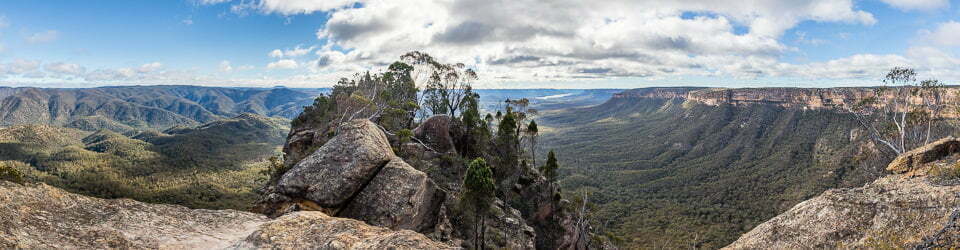
The climb to Gungartan was mostly on snow but across to the next saddle there was barely any. Here the skis were very useful to walk across the bushes and small creeks but it was very slow going. Once to the saddle a short detour was taken to climb a prominent small rock outcrop at the top of the creek on the other side. From here the panoramic views across the Rolling Ground to the Main range and around to the Grey Mare Range were stunning. Photos taken, it was a very slow pole assisted decent to the road before more of the same down to the Aquaduct track. This section was very tiring with frequent stops to take off or put on skis but there was more snow along here than I anticipated.
It was great to get back to the car in time to drive home but very disappointing to be cutting my trip short, after all I was carrying out at least three days of food but had lots of great memories and hopefully photos as well. It was also great to see the police radar set up at the bottom of the chain fitting lane at Wilsons Valley (just before the 80 sign) as I passionately hate people who speed. Nice and friendly too, he waved and flashed his lights at me as I went past, no worries as I had checked my speed to only be 98km/h as soon as I had seen him. Then the thought occurred, it is a 100km/h limit along that section isn’t it? To make matters worse, for life of me I couldn’t recall seeing a speed limit sign since Guthega Road. Guess I’ll find out soon.
PS. I have heard nothing but I noted of my next trip along this road that the speed limit now is 80km/h.
Clickable icons on a world map which open the related trip report
A detailed, searchable trip list with links to reports, photo galleries and other content
![]()