
Sunday 25/02/2024 Hartz Peak Track Carpark – Lake Osborne + Arve Falls Track Carpark – Arve Falls + Waratah Lookout
Hartz Mountains National Park, lutruwita / TASMANIA
Palawa Country
Participants: Stephen Davies (Photos), Sue Davies (Report)
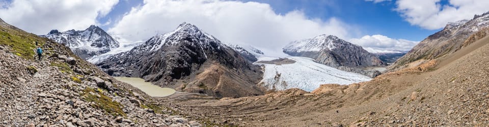
We awoke to a fiery sunrise and decided to complete the local short walks before moving on. This World Heritage Area has impressive landscapes and unique vegetation and wildlife. Lake Osborne is a glacial lake formed about 18,000 years ago. A gently climbing boardwalk through Myrtle rainforest across the Hartz Plateau leads to this picturesque glacial lake.
Max elevation: 926 m
Total climbing: 100 m
Total descent: -98 m
Average speed: 3.61 km/h
Total time: 00:50:46

Su eon Lake Osborne Track
Endangered King Billy pines, hundreds of years old fringe the lake. They are extremely sensitive to fire and recent blazes have unfortunately reduced their number to a few dozen. We returned via the same path.
Arve Falls
A short walk following the course of the Arve River through snow gum woodland lead to falls.
Max elevation: 802 m
Total climbing: 33 m
Total descent: -38 m
Average speed: 3.86 km/h
Total time: 00:25:48

Arve Falls
Waratah Lookout
This short walk leads to a viewing platform overlooking the Huon Valley and logging areas. In December and January Waratah are in flower but unfortunately not today.

Views from Waratah Lookout
Edgar Campground
From Waratah Lookout we drove around to Lake Pedder in preparation for tomorrows planned walk, an attempt to reach the Shelfcamp Campsite on the Mount Anne Circuit.
Max elevation: 326 m
Total climbing: 26 m
Total descent: -11 m
Average speed: 3.82 km/h
Total time: 00:25:25

Lake Pedder from Edgar Dam
Information on Parks Tasmania signage along the way
LAKE OSBORNE – CARVED BY ICE, RINGED BY FIRE
t the height of the last ice age 18,000 years ago—a mere instant in the geological time scale—small glaciers filled many of the mountain valleys within Tasmania. The landforms they created are still as ‘fresh’ as when the ice retreated, allowing us to turn back time and explore an ice age landscape.
The glacier that once crept down this valley halted, starved of ice by a warming climate. As it melted away, it released the rock debris (moraine) it carried and abandoned the unfinished wall it had been ‘bulldozing’ before it. The result was a moraine barrier that dammed the runoff from the mountains creating Lake Osborne.
Fire has also played its part in shaping the pattern of life here. The King Billy pines fringing the lake are extremely sensitive to fire and recent fires have reduced their number to a few dozen. You can just about count them all from here. Many of these trees are hundreds of years old.
Fire and ice have become partners in nature—shaping and reshaping the land and the plants and animals that bring that land to life.
The inclusion of this landscape in the World Heritage Area ensures that these processes will continue-shaping tomorrow’s landscapes and providing clues to those of the past.
The local landscape features, geology, scenic highlights, flora, fauna, indigenous history, white history and other walks in the area (Gemini)
Landscape Features:
Rugged Mountains: The park’s defining characteristic is its dramatic mountain ranges, including the imposing Frenchmans Cap, the highest peak in Tasmania at 1,443 meters. These weathered peaks, sculpted by millions of years of erosion, create a sense of wilderness and grandeur.
Glacial Valleys: U-shaped valleys, carved by glaciers during past ice ages, like the Cradle Valley and Lake St Clair, showcase the erosive power of nature and cradle serene lakes and lush vegetation.
Temperate Rainforests: Towering rainforests, dominated by myrtle beech and celery pine, cloak the mountain slopes and valleys. These ancient forests provide a cool, green haven and habitat for diverse plant and animal life.
Waterfalls and Lakes: Cascading waterfalls, like the powerful Ballroom Forest Falls and the serene Waldheim Falls, add to the park’s scenic beauty. Pristine lakes like Lake Rodway and Lake King William offer opportunities for reflection and tranquillity.
Geology:
The dramatic landscapes of Hartz Mountains National Park are a testament to its ancient geological history. The mountains are composed of dolerite, a hard rock formed from cooling lava flows approximately 180 million years ago. Subsequent glacial activity sculpted the valleys, leaving behind U-shaped landscapes and creating fertile ground for vegetation.
Scenic Highlights:
Cradle Mountain Summit Hike: Ascend the challenging yet rewarding Cradle Mountain summit walk, enjoying panoramic vistas of surrounding peaks, glacial valleys, and ancient rainforests.
Lake St Clair – Cradle Valley Circuit: Embark on a multi-day hike along the renowned Lake St Clair – Cradle Valley Circuit, traversing diverse landscapes, encountering waterfalls, and immersing yourself in the wilderness.
Waterfall Walks: Discover hidden waterfalls like the Ballroom Forest Falls or the cascading Waldheim Falls along shorter walking tracks, perfect for capturing the power and beauty of these natural wonders.
Local Flora:
The diverse habitats within Hartz Mountains National Park support a rich tapestry of plant life:
Temperate Rainforests: Towering trees like myrtle beech (Nothofagus cunninghamii), celery pine (Phyllocladus aspleniifolius), and sassafras (Atherosperma moschatum) dominate the rainforest canopy, while the understory boasts ferns, mosses, and colourful fungi.
Alpine Heaths: Above the tree line, windswept alpine heaths, dominated by low-growing shrubs like mountain pepper (Tasmannia lanceolata) and cushion plants, showcase resilience in harsh conditions.
Riparian Vegetation: Along riverbanks and around lakes, reeds, rushes, and sedges thrive, providing habitat for aquatic insects and birds.
Local Fauna:
Keep your eyes peeled for Tasmania’s unique and diverse fauna while exploring Hartz Mountains National Park:
Mammals: Spot elusive Tasmanian devils, pademelons, and wallabies amongst the vegetation. Look out for shy platypus in the waterways and listen for the calls of echidnas at dusk.
Spot elusive Tasmanian devils, pademelons, and wallabies amongst the vegetation. Look out for shy platypus in the waterways and listen for the calls of echidnas at dusk.
Birds: Diverse birdlife fills the park with song. Listen for the calls of colourful parrots like the green rosella (Platycercus callodes) and the eastern rosella (Platycercus eximius), as well as honeyeaters, kookaburras, and raptors like wedge-tailed eagles (Aquila audax) soaring through the skies.
Reptiles and Amphibians: Basking lizards and skinks might be spotted on sunny rocks, while frogs like the spotted tree frog (Litoria punctata) croak near water bodies.
Indigenous History:
The traditional lands of the Palawa people encompass the Hartz Mountains National Park area. Evidence of their long connection to the land can be found in middens and stone artefacts scattered throughout the region. The Palawa people hold a deep spiritual connection to the mountains, lakes, and rainforests, considering them places of great significance in their cultural traditions.
White History:
European explorers first arrived in the area in the early 1800s. The harsh environment initially discouraged settlement, but later saw attempts at mining and grazing. Conservation efforts gained momentum in the early 20th century, culminating in the declaration of the Hartz Mountains National Park in 1951. Recognizing the ongoing cultural connection of the Palawa people to the land is vital for respecting the park’s rich heritage.
Clickable icons on this world map will open the related trip report
A detailed, searchable trip list with links to reports, photo galleries and other content
![]()