
Friday 23/02/2024 Fern Tree – Mount Wellington – Panorama Track – Tree – O’Grady’s Falls
Wellington Park, lutruwita / TASMANIA
Palawa Country
Participants: Stephen Davies (Photos), Sue Davies (Report)
We had a pretty relaxed start today thinking the walk was just over 10km and just as we were about to start Steve realised his watch needed to be charged so we waited a further 30 minutes, finally heading off just after 10:00am.
Max elevation: 1270 m
Total climbing: 1056 m
Total descent: -1044 m
Average speed: 3.67 km/h
Total time: 07:32:55
Leaving Fern Tree and climbing up some mossy stairs we found a really beautiful lush fern forest despite the recent dry conditions. The path was well formed and the walking was pleasant. The climbing was gradual initially before becoming steeper. The vegetation changed quite markedly as we went higher.
We soon discovered that the most direct route to the summit, the Zig Zag Track was closed which meant we needed to take a longer route to the summit. The ferns gave way to a gum tree-lined path strewn with rocks covered with white lichen. We would see so many of these types of rocks today! There were a variety of different coloured berries and I did spot a small swamp wallaby amongst the vegetation. There were many small dark skinks running amongst the boulders.
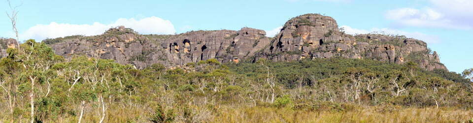
The next section of the climb was quite rocky and we needed to clamber over rocks large and small. Luckily most of them were stable. Continuing our ascent the views soon emerged of Hobart and surroundings below. It was quite scenic but the wind was certainly starting to bite. It was a complete change from the heat of yesterday when it reached 35 degrees!
Further along and up we were able to see evidence of the summit ahead but the next section seemed to take a long time. It involved climbing through a boulder field, at times losing the track, it was slow going. We soon reached the upper section of the closed Zig Zag Track only to find that there was only about 50 metres of track building remaining to be built!
Now up high and in the open it was very cold and windy, so we were thankful to reach the summit shelter where we ate our lunch. Several people who had driven to the lookout (as most ‘normal’ people would do!) were amazed that we had walked up. One woman even offered to drive us back to our car!
Steve was not keen to go back along the same wind-exposed route so he decided we should take the slightly longer but hopefully easier route via the Panorama Track. This involved some road walking, surprising as it is a recognised route and the track just ends at the road! There were more boulder fields to negotiate, steps and some undulations. It was quite scenic in places and of course, the vegetation changed quite dramatically on our descent. This track took us past the Octopus Tree and O’Grady’s Falls which were both worth a look.

Sue crossing a scree slope along Hunters Track
Towards the end, we were forced to pay close attention to the map (as there were a multitude of trails in the area) before we made it back to our car. It ended up being a much longer walk than we had intended and it will be much improved with the reopening of the Zig Zag track which should occur very soon.
Information on Parks Tasmania signage along the way
Welcome to Fern Tree WELLINGTON PARK
Fern Tree is the gateway to Wellington Park.
You are now in the foothills of one of the most visited destinations in Tasmania – the summit of Hobart’s beloved mountain, kunanyi / Mount Wellington. If you’re driving, the top of the mountain is another 20 minutes up Pinnacle Road. If you’re on foot, it’s two and a half hours of walking through beautiful eucalypt forest and huge dolerite boulder fields.
Exploring
More than 40 walking tracks traverse this glorious mountain.
We’ve described the most popular experiences departing from here – many combining several tracks to reach the destinations. Additional walks depart from The Springs.
You may also find it helpful to photograph this map and walk descriptions in case you need a tittle extra reassurance while out exploring.
About this place
The Muwinina people thrived on this Country for more than 40,000 years. They were strongly connected to kunany, Mount Wellington, the rivulets and River Derwent.
Tasmanian Aboriginal people represent the southernmost, oldest continuing culture in the world. They are recognised as the Custodians of this land.
This entrance to Fern Glade Track dates back to 1946, but the area has long been used by travellers. The stone trough by Dunn’s Creek possibly since 1869 when Huon Road was constructed. Horses bringing visitors from trough before heading higher up kunanyi / Mount Wellington.
Fern Glade Track starts from just above the present entrance and gets its name from the magnificent tree ferns that delighted walkers who took this path.
Historically. Fern Clade Track was one of two key walking tracks from Fern free to The Springs, from where tracks then climbed to the summit of Mount Wellington as they do today.
There have been visitor facilities at The Springs for walkers since the 1850s – initially a hut and refreshments provided by the Woods family, from 1907 it was the site of the Springs Hotel.
CHARLES DARWIN IN HOBART TOWN
Mound Wellington
Charles Darwin wrote in his record of the voyage of HMS Beagle that Hobart Town “stands at the base of Mount Wellington, a mountain of little picturesque beauty.” Still, it was attractive enough for him to spend two days in efforts to climb it. On 10 February 1836 he set off via South Hobart and the brewery at the Cascades hoping to take a direct route to the top. It was a frustrating waste of time.
Somewhere above the head of Myrtle Gully near Crocodile Rock he and his assistant were forced to turn back: “We were foiled by the thickness of the wood.”
The following day was hot and windy but he tried again. This time he engaged a guide whom he later criticised. “Our guide, however, was a stupid fellow, and conducted us to the southern and damp side of the mountain where the vegetation was very luxuriant, and where the labour of ascent … was great.”
Geology of the mountain
The climb revealed to him the geological order of the rocks which he had found so difficult to understand nearer the town. The sequence was: “Strata with impressions (fossils), half-Slate, Chert, Sandstone, Limestone, capped by sandstone, reddish … rest Greenstone.” He thus recorded the succession of sometimes fossiliferous Permian rocks (about 280 million years old), Triassic sandstones above the Springs (about 240 million years old), and the Jurassic dolerite (about 175 million years old) capping of the mountain. The views from the top were memorable.
Coastal view “The day was splendidly clear & we enjoyed a most extensive view … To the south the intricate outline of the broken land & water forming many bays was mapped with clearness before us.” This is a landscape drowned by sea level rise.
Plateau view “The summit of Mount Wellington is broad, level and of considerable extent; looking to the W. and N.W. numberless mountains of the same form and height are seen; these in parts are said almost to unite into an elevated central plateau….” Later students of landforms also have inferred that the forms and elevations indicate an uplifted plateau.
Very hard work
They then returned “after staying some hours on the summit, we found a better way to descend.” It had been “a severe day’s work.” We may infer his route up the mountain from his comments: up Davey Street to Fitzroy Gardens, to Waterworks, to Fern Tree, to south of The Springs, to near Icehouse Track, across South Wellingtons to the summit. His other route down may have been closer to the Pinnacle Track.
The local landscape features, geology, scenic highlights, flora, fauna, indigenous history, white history and other walks in the area (Gemini)
This hike explores the diverse landscapes of Wellington Park, ascending Mount Wellington via Fern Tree and descending via the Panorama Track.
Landscape Features and Geology
Underlying geology: The hike traverses foothills composed of Precambrian dolerite, an intrusive igneous rock. Ascendancy reveals Jurassic sandstone, responsible for the dramatic cliffs and dolerite screes encountered higher on the mountain.
Landforms: The route includes sections of rainforest gullies, steep climbs over rocky slopes, and boulder fields sculpted by glacial activity.
Scenic Highlights
Fern Gully: The initial ascent from Fern Tree traverses a sheltered and scenic fern gully, characterised by lush vegetation and damp conditions.
Panoramic vistas: As elevation increases, glimpses of Hobart and the surrounding suburbs emerge. Higher sections offer uninterrupted panoramic views encompassing southern Tasmania.
O’Grady’s Falls: The descent via the Panorama Track includes a detour to O’Grady’s Falls, a picturesque waterfall nestled within a rainforest setting.
Local Flora
The vegetation varies with altitude and aspect:
Rainforest gullies: Lower slopes support a dense rainforest dominated by myrtle (Nothofagus cunninghamii) and sassafras (Atherosperma moschatum). A diverse array of ferns, mosses, and liverworts flourishes in the understorey.
Montane forests: Mid-altitude sections feature drier forests with eucalyptus (Eucalyptus spp.) as the dominant canopy species. Shrubs such as mountain pepper (Tasmannia lanceolata) and musk daisy (Olearia lirata) may be present.
Alpine vegetation: Higher elevations are characterised by low-lying shrubs such as snow gum (Eucalyptus pauciflora) and cushion plants adapted to the harsh conditions.
Local Fauna
The diverse habitats offer opportunities to encounter a range of animals:
Birds: Species such as scrub robins (Drymodes olivacea) and grey fantails (Rhipidura albiscapa) may be seen flitting amongst the foliage. Less commonly seen but potentially present are pademelons (Thylogale spp.) and Tasmanian devils (Sarcophilus harrisii) in sheltered gullies.
Reptiles: Skinks (Lygosoma spp.) are commonly encountered amongst rocks. Snakes are present but sightings are less frequent.
Indigenous History
The Palawa people are the traditional custodians of the land now encompassed by Wellington Park. Evidence suggests Aboriginal Tasmanians inhabited the lower slopes of Mount Wellington, utilising the diverse resources provided by the forests. Oral histories and cultural knowledge may provide insights into their connection to this place. Consultation with Tasmanian Aboriginal people is needed for a deeper understanding of their relationship with this route.
White History
European exploration of the region began in the early 19th century. Logging activities likely impacted some areas in the late 19th and early 20th centuries. The dedication of Wellington Park in 1916 secured the region’s natural and scenic values for future generations. The development of walking tracks allows access to experience the diverse landscapes of the area while aiming to minimise environmental impact.
Other Nearby Walks
Wellington Park offers a variety of walking tracks catering to different interests and fitness levels:
Pillinger Drive Track: A short loop track offering views of Hobart and the surrounding suburbs.
The Neck Track: A moderate return walk following a scenic ridgeline with panoramic vistas.
Cynthia Bay Track: A challenging one-way track leading to the dramatic cliffs of the dolerite plateau.
The combination of diverse landscapes, scenic vistas, and unique flora encountered along the Fern Tree – Panorama Track makes this route a rewarding experience for walkers seeking a challenging day hike.
Clickable icons on this world map will open the related trip report
A detailed, searchable trip list with links to reports, photo galleries and other content
![]()