
Tuesday 22/10/2023 Three Short Walks
Mount Arapiles – Tooan State Park, VICTORIA
Wotjobaluk Country
Participants: Stephen Davies (Photos, Report)
Tuesday 22/10/2023 Nature Walk off Mount Arapiles Summit Road
We completed this short nature walk and were left unimpressed. Although it is a very easy walk and there were plenty of spring wildflowers the track itself has fallen into a state of disrepair. In sections, you can’t see where it is supposed to go and the numbered signposts have no explanatory information available to go with them, as the entry box at the entrance was empty. I also think a lot of the things the signs were meant to be placed near have probably long gone from the landscape as it is today.
Max elevation: 182 m
Total climbing: 33 m
Total descent: -36 m
Average speed: 3.08 km/h
Total time: 00:20:52

Mount Arapiles Nature Park
Tuesday 22/10/2023 Bluff Lookout – Summit Picnic Area – Bushranger Bluff: Main Wall – Melville Cave
Today we drove to Bluff Lookout and Summit Picnic Area Lookouts as part of our initial overview of the area.
Max elevation: 214 m
Total climbing: 47 m
Total descent: -43 m
Average speed: 3.65 km/h
Total time: 00:16:05

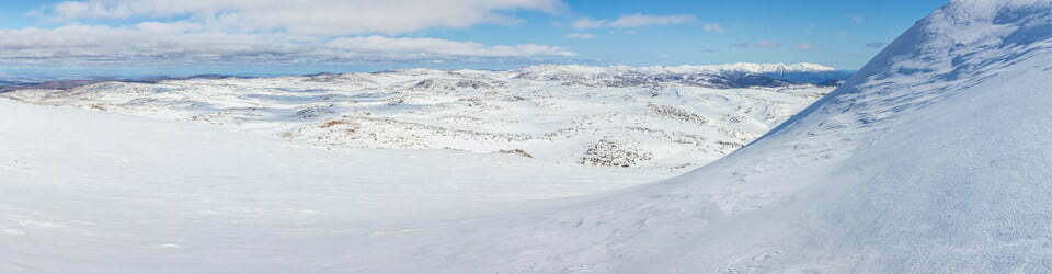
Views from Bluff Picnic Area And Lookout
Following lunch, we completed the very short walk to Melville Cave. This was not what was expected so we didn’t need the headlamp we had taken. The cave sits up on the cliff, so a genuine rock climb would be required to reach it. What we did find was a group of people climbing a nearby wall.
Tuesday 22/10/2023 The Pines-Centenary Park Campground – Upper Centenary Park Track
After settling into camp we completed a very short walk to the north of camp on the track just above the road past camp. This took in a view to a lot of the climbing routes of the northern section. We heard a lot of birds in the heath as we walked through and occasionally caught a glimpse of one. There were also a couple of swamp wallabies about.
Max elevation: 178 m
Total climbing: 143 m
Total descent: -149 m
Average speed: 3.16 km/h
Total time: 01:31:12

Mount Arapiles from near The Pines
A section of along here is also currently closed due to cultural heritage concerns. This is very well signposted to inform visitors.
Thursday 24/10/2023 The Pines-Centenary Park Campground – Southern Section of Mount Araplies – Mount Arapiles Summit Road
Another short walk of the area taking in the southern end of Mount Arapilies from our campsite to the summit road. There was plenty of birdlife and flowers along the way and yet another climbing area where the was an active group trying out the rock.
Max elevation: 212 m
Total climbing: 146 m
Total descent: -140 m
Average speed: 3.00 km/h
Total time: 02:09:10
Returning to camp there was a magpie that had taken a special interest in some “food” left behind to be shared, of concern was the laundry powder amongst it, certainly not something on anyone’s diet.
The local flora, fauna, geology, history and some other walks (Bard)
Local Flora
The local flora of Mount Arapiles-Tooan State Park is a diverse mix of woodland, grassland, and heathland vegetation. The woodland is dominated by Eucalyptus species, such as the red gum (Eucalyptus camaldulensis), the yellow gum (Eucalyptus leucoxylon), and the greybox (Eucalyptus microcarpa). The grassland is dominated by native grasses such as kangaroo grass (Themeda australis), wallaby grass (Danthonia spp.), and spear grass (Stipa spp.). The heathland is dominated by shrubs such as wattles (Acacia spp.), grevilleas (Grevillea spp.), and hakea (Hakea spp.).
Local Fauna
The local fauna of Mount Arapiles-Tooan State Park is also diverse and includes a variety of mammals, birds, reptiles, and amphibians. Some of the common mammals include kangaroos, wallabies, wombats, koalas, and echidnas. Some of the common birds include emus, kookaburras, parrots, honeyeaters, and wrens. Some of the common reptiles include snakes, lizards, and turtles. Some of the common amphibians include frogs and toads.
Geology
Mount Arapiles – Tooan State Park is located in the Wimmera Plains, which is a large basalt plain in western Victoria. The park is underlain by a variety of volcanic rocks, such as basalt and tuff. The park also contains some sedimentary rocks, such as sandstone and shale.
Indigenous History
The Aboriginal people of Australia have lived in the area now known as Mount Arapiles-Tooan State Park for thousands of years. The park is on the traditional land of the Wotjobaluk people. The Wotjobaluk people used the land for hunting, gathering, and fishing. They also used the land for ceremonial and spiritual purposes.
White History
The first Europeans to visit the area now known as Mount Arapiles – Tooan State Park were explorers Hamilton Hume and William Hovell in 1824. The area was first settled by Europeans in the 1830s. The park was established in 1977.
Walks
Mount Arapiles – Tooan State Park has a number of walking trails, ranging in difficulty from easy to difficult. Some of the popular walks include:
The Arapiles Ridge Walk: This is a moderate 4 km walk that takes in some of the most scenic views in the park, including the Arapiles Ridge, a series of rock formations that offer stunning views of the surrounding countryside.
The Tooan Creek Walk: This is an easy 2 km walk that follows Tooan Creek. The walk passes through woodland, grassland, and wetland vegetation.
Additional Information
The park is also home to a number of rock art sites and Aboriginal burial grounds.
The park is a popular destination for rock climbers, with over 1000 climbing routes located throughout the park.
The park is also a popular destination for birdwatchers, with over 200 species of birds recorded in the park.
Clickable icons on this world map will open the related trip report
A detailed, searchable trip list with links to reports, photo galleries and other content
![]()